
Gambo is a town and designated place in the Canadian province of Newfoundland and Labrador. Located in the northeastern portion of the island of Newfoundland on Freshwater Bay, it is in Division No. 7.
Appleton is a town in the northeastern part of Newfoundland in the province of Newfoundland and Labrador, Canada.
Division No. 8 is a census division on the north coast of the island of Newfoundland in the province of Newfoundland and Labrador, Canada. It has a land area of 9,314.57 km² and had a population of 33,940 at the 2016 census. Its largest communities are the towns of Lewisporte, Springdale, and Twillingate.

Peterview is a town located in the Exploits Valley area of central Newfoundland and Labrador, Canada, where Peters River empties into the Bay of Exploits, just south of Botwood, off Route 350.

Sandy Cove is a town located on the Eastport Peninsula in Newfoundland and Labrador, Canada. It is located on Newman Sound, which is part of Bonavista Bay. It had a population of 120 in the 2021 census.
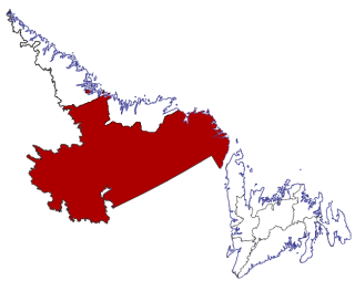
Census Division No. 10 of Newfoundland and Labrador is composed of the Labrador region of the province, excluding Nunatsiavut. It has a land area of 199,703 km² (77,105.8 sq mi) and at the 2016 census had a population of 24,639, up from 24,111 in 2011. Its two major population centres are the towns of Happy Valley-Goose Bay and Labrador City.
Colinet is an incorporated town located on the northwest arm of St. Mary's Bay in Newfoundland and Labrador, Canada.
Duntara is a town located north west of Catalina, Newfoundland and Labrador. Duntara was an Incorporated Community on October 21, 1961.
Cobb's Arm is a local service district and designated place in the Canadian province of Newfoundland and Labrador on New World Island. It is located about 8 km outside Newville and leads to other communities such as Pikes Arm and Toogood Arm.
Michael's Harbour is a designated place in the Canadian province of Newfoundland and Labrador. It is just outside Lewisporte. There are no stores or services and residents must commute to Lewisporte for essential services and Campbellton for education until the 9th grade. They commute to Lewisporte for high school. The community had a crisis in 2020 where a house burned down and it was determined that no fire department was obliged to provide services to the community. In February of the same year, the issue was resolved where the Lewisporte Fire Department agreed to provide service in exchange for CA$50 fee per homeowner.

Comfort Cove-Newstead is a small fishing community located outside Campbellton, on the east coast of Newfoundland and Labrador, Canada,.

Humber Arm South is a town in the Canadian province of Newfoundland and Labrador. The town consists of the communities of Halfway Point, Benoit's Cove, John's Beach, and Frenchman's Cove. The town had a population of 1,537 in the Canada 2021 Census. The Town's Post Office is located in Benoit's Cove. Humber Arm South is located in the Bay of Islands and is in the Humber-Bay of Islands electoral district. The town's residents are of Mi'kmaw, Innu, and European descent.
Jackson's Arm is a town in the Canadian province of Newfoundland and Labrador, located on White Bay. It was settled by John Wicks of Christchurch, England, around 1870. The Post Office was established in 1892 and the first Postmistress was Belinda Peddle. The town had a population of 435 in 1956 and 277 as of the 2021 Canadian census. The primary industry of the town is fishing. In 2012, the local fish plant closed.
Middle Arm is a village in the Canadian province of Newfoundland and Labrador. It is located on the northern shore of an inlet of Notre Dame Bay in the north-central part of Newfoundland.
South Brook is a town in the Canadian province of Newfoundland and Labrador. It is located in the center region of the island of Newfoundland. The town had a population of 420 in 2021, down from 482 in the Canada 2016 Census.
Old Shop is a local service district and designated place in the Canadian province of Newfoundland and Labrador. It is on the western side of the Dildo Arm, at the southern end of Trinity Bay. It is northwest of South Dildo, across the Dildo Arm from Dildo proper.
Snook's Arm is a designated place in the Canadian province of Newfoundland and Labrador. The community was entirely resettled in 2018.
Brown's Arm is a local service district and designated place in the Canadian province of Newfoundland and Labrador
Roddickton-Bide Arm is a town located in the northern peninsula of the island of Newfoundland within the province of Newfoundland and Labrador. It was formed on January 1, 2009 through the amalgamation of the former towns of Roddickton and Bide Arm.
Norris Arm North is a local service district and designated place in the Canadian province of Newfoundland and Labrador. The place is also known as Alderburn. It was originally a fishing and farming settlement.

