
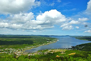
Peterview is a town located in the Exploits Valley area of central Newfoundland and Labrador, Canada, where Peters River empties into the Bay of Exploits, just south of Botwood, off Route 350.
Steady Brook is a Canadian town in the province of Newfoundland and Labrador. Located on the west coast of the island of Newfoundland, the town is situated 8 kilometres east of the city of Corner Brook in the lower Humber Valley. The town is surrounded by the Long Range Mountains and sits astride the Humber River. Steady Brook has become a thriving community in recent years as a result of provincial investments in the Marble Mountain alpine ski resort, along with golf courses and other recreational amenities.
Gillams is a town located north west of the city of Corner Brook in the Canadian province of Newfoundland and Labrador.

Reidville is a village located north east of Deer Lake. A post office was established in 1967 and the first Postmisstress was Dorothy Barrett.
Little Bay is a town located in the Canadian province of Newfoundland and Labrador. Its current population is about 166 people. It is located in Green Bay, which is part of Notre Dame Bay, which is located in the central part of Newfoundland and Labrador. Some towns near Little Bay include Beachside, St Patrick's, Little Bay Islands, and the main center for Green Bay, Springdale.
Point Leamington is a town of about 590 people located north of Botwood and Grand Falls-Windsor in the Canadian province of Newfoundland and Labrador.
Embree is a small community just outside Lewisporte. It is a drive-through town that eventually leads into neighbouring Little Burnt Bay.
Glenburnie-Birchy Head-Shoal Brook is a town in the Canadian province of Newfoundland and Labrador. The town had a population of 224 in the Canada 2016 Census.
Howley is a town in the Canadian province of Newfoundland and Labrador, with a population of 205. It is located on Route 401, 13 km from the Trans-Canada Highway, approximately thirty minutes' drive from the Deer Lake Airport. Services include a pub, a convenience store, a bed and breakfast, a campground, and a hotel.
Lamaline is a town in the Canadian province of Newfoundland and Labrador. The town had a population of 480 in 1940, 643 in 1956 and 218 in the Canada 2021 Census. Lamaline was a small place with 10 families in 1864. The Way Office was established in 1863 and the first Waymaster was James Pittman.

LaScie is a town in the Canadian province of Newfoundland and Labrador. The town had a population of 820 in the Canada 2021 Census, down from 872 in 2016.

Leading Tickles is a town in the Canadian province of Newfoundland and Labrador. In 2016, the town had a population of 292, down from 407 in the Canada 2006 Census. It is located approximately 25 km Northwest of Point Leamington on the shores of Notre Dame Bay. The town boasts spectacular scenery especially in spring and early summer when many icebergs pass just off the coast.
Miles Cove is a town on Sunday Cove Island in the Canadian province of Newfoundland and Labrador. The town had a population of 104 in 2016, down from 140 in the Canada 2006 Census.
Northern Arm is a town in the Canadian province of Newfoundland and Labrador. The town had a population of 426 in the Canada 2016 Census.
Point of Bay is a town in the Canadian province of Newfoundland and Labrador. The town had a population of 154 people in 2016, down from 163 in the Canada 2006 Census.
Port Anson is a town on Sunday Cove Island in the Canadian province of Newfoundland and Labrador. The town had a population of 130 in 2016, down from 155 in the Canada 2006 Census.
Sandringham is a town on the Eastport Peninsula in Bonavista Bay North in the Canadian province of Newfoundland and Labrador, Canada. The town had a population of 229 in the Canada 2016 Census.
St. Pauls is a town in the Canadian province of Newfoundland and Labrador. The town had a population of 238 in the Canada 2016 Census.
Westport is a town in the Canadian province of Newfoundland and Labrador. The town had a population of 185 in 2021, down from 195 in the Canada 2016 Census.
Lushes Bight–Beaumont–Beaumont North is a town on Long Island in Notre Dame Bay in the Canadian province of Newfoundland and Labrador. The town had a population of 168 at the 2016 Census, down from 275 in the 2006 Census.