
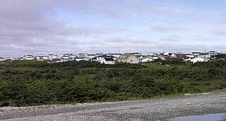
Channel-Port aux Basques is a town at the extreme southwestern tip of Newfoundland fronting on the western end of the Cabot Strait. A Marine Atlantic ferry terminal is located in the town which is the primary entry point onto the island of Newfoundland and the western terminus of the Newfoundland and Labrador Route 1 in the province. The town was incorporated in 1945 and its population in the 2021 census was 3,547.
Division No. 8 is a census division on the north coast of the island of Newfoundland in the province of Newfoundland and Labrador, Canada. It has a land area of 9,314.57 km² and had a population of 33,940 at the 2016 census. Its largest communities are the towns of Lewisporte, Springdale, and Twillingate.

Twillingate is a town of 2,121 people located on the Twillingate Islands ("Toulinquet") in Notre Dame Bay, off the north eastern shore of the island of Newfoundland in the province of Newfoundland and Labrador, Canada. The town is about 100 kilometres (62 mi) north of Lewisporte and Gander.
Hant's Harbour is an incorporated town located on the east side of Trinity Bay on the Bay de Verde Peninsula in the province of Newfoundland and Labrador, Canada. It has a population of 318 according to the 2021 Canadian census.

Port Hope Simpson is a town located on the southeastern Labrador coast, 215 km (134 mi) from the Quebec/Southern Labrador border in Canada. In 1944 it was named after John Hope Simpson as a company town.
Cape Ray is a local service district and designated place in the Canadian province of Newfoundland and Labrador. It is on the southwest coast of the island of Newfoundland.

Isle aux Morts is a small town on the Southwest Coast of the Island of Newfoundland, with a population of 559 (2021). The town is located approximately 16 km (9.9 mi) east from the Marine Atlantic Ferry Terminal in Port aux Basques along Route 470.
Anchor Point is a town located in St. Barbe Bay, south of Flower's Cove on the west side of the Great Northern Peninsula, in Newfoundland and Labrador, Canada. It was the first English settlement on what is called the 'French Shore' of Newfoundland.
Conche is a community on the Northern Peninsula of Newfoundland and Labrador, Canada. Its population in 2021 was 149.
Triton is a town that lies on Triton Island just off the coast of northeastern Newfoundland, in the Canadian province of Newfoundland and Labrador. Triton is the economic center of Green Bay South. According to Statistics Canada, Triton's population fell from 983 in 2016 to 896 in 2021.
Virgin Arm–Carter's Cove is a local service district and designated place on New World Island in the Canadian province of Newfoundland and Labrador. Virgin Arm-Carter's Cove is located approximately 90 km Northwest of Gander in Subdivision H of Division No. 8.

Reefs Harbour-Shoal Cove West-New Ferolle is a local service district and designated place in the Canadian province of Newfoundland and Labrador. It is southwest of Anchor Point.

Rose Blanche – Harbour le Cou is a small town on Newfoundland's southwest shore, about 45 km at the end of Route 470 from Port aux Basques. This community is located in a barren area on the east side of a small bay. In this bay there are 2 harbours that were mainly used to provide shelter for fishing vessels. Scenery includes the rugged granite coastline, and the white and rocky cliffs of "Diamond Cove". Its granite lighthouse was in operation from 1873 to the 1940s. After it was abandoned in the 1940s the building fell into ruins. The spiral stone staircase extends into the tower wall and kept the tower from collapsing while the remainder of the lighthouse fell to ruin. In 1999 the lighthouse was fully reconstructed and serves as a tourist attraction.

Lark Harbour is small fishing community on the western coast of Newfoundland, on the south side of the Bay of Islands, and west of the City of Corner Brook.

Nipper's Harbour is a town located on the east coast of the Baie Verte Peninsula of Newfoundland in the Canadian province of Newfoundland and Labrador. This incorporated community of 85 people is located on a rocky inlet that combines Nipper's Harbour and Noble's Cove, and where the primary industry is the inshore fishery. The town is approximately 58 km from Baie Verte.
Grand Bruit is a designated place and former settlement in the Canadian province of Newfoundland and Labrador. It is on the southwestern coast of the island of Newfoundland. Grand Bruit was resettled in 2010. The community was divided down the middle by a waterfall, hence the name "Grand Bruit" which is French for "great noise".

St. Jacques-Coomb's Cove is a town in the Canadian province of Newfoundland and Labrador. The town had a population of 546 in the Canada 2021 Census. It is located on the south coast of the island of Newfoundland on the north side of Fortune Bay, on the southern tip of the Connaigre Peninsula in what is now known as the Coast of Bays Region. The town consists of six communities, St. Jacques, English Harbour West, Mose Ambrose, Boxey, Coomb's Cove, and Wreck Cove, all nestled within the inlets along the coast. They all had their beginnings in the fisheries and the fisheries have always been the mainstay of employment in the communities. In recent years aquaculture was introduced in the area, providing employment for its residents.
Merritt's Harbour is a local service district and designated place in the Canadian province of Newfoundland and Labrador. It is located near Herring Neck, on New World Island, a few kilometers south of the causeway to Twillingate.
Brigus Junction is a designated place in the Canadian province of Newfoundland and Labrador.
Division No. 3, Newfoundland and Labrador is a census division in the Canadian province of Newfoundland and Labrador, primarily comprising the South Coast of the island of Newfoundland, starting roughly 10km northwest of Channel-Port aux Basques and ending roughly 10km east of Rencontre East. Like all census divisions in Newfoundland and Labrador, but unlike the census divisions of some other provinces, the division exists only as a statistical division for census data, and is not a political entity.

