Bonavista, Newfoundland and Labrador

Last updated

Bonavista
Town
Bonavista harbour.JPG
Bonavista Harbour, looking north. The large building in the centre of the photo houses a replica of John Cabot's ship, Matthew
Canada Newfoundland location map.svg
Red pog.svg
Bonavista
Location of Bonavista in Newfoundland
Coordinates: 48°39′35″N53°07′15″W / 48.65972°N 53.12083°W / 48.65972; -53.12083
CountryCanada
Province Newfoundland and Labrador
Government
  MayorJohn Norman
Area
 (2016) [1]
  Land31.5 km2 (12.2 sq mi)
Population
 (2021) [1]
  Total3,190
  Density109.4/km2 (283/sq mi)
Time zone UTC−03:30 (NST)
  Summer (DST) UTC−02:30 (NDT)
Area code 709
Highways NL Route 230.svg Route 230
NL Route 235.svg Route 235
NL Route 238.svg Route 238
Website townofbonavista.com OOjs UI icon edit-ltr-progressive.svg

Bonavista (2021 population: 3,190 [1] ) is a town on the Bonavista Peninsula, Newfoundland in the Canadian province of Newfoundland and Labrador. Unlike many Newfoundland coastal settlements, Bonavista was built on an open plain, not in a steep cove, and thus had room to expand to its current area of 31.5 km2 (12.2 sq mi). [1] Bonavista is located approximately 300 km by road from the provincial capital of St. John's.

Contents

History

John Cabot (Giovanni Caboto), a freelance Italian explorer, was contracted by England's Henry VII to find new lands, and a sea route to the Orient. Cabot set sail from Bristol, England in his ship the Matthew in 1497. When Cabot first saw land he reputedly said "O Buon Vista" ("Oh, Happy Sight!") [2] [3] giving rise to the name of the town and nearby Cape Bonavista. Cabot landed with "a crucifix and raised banners with the arms of the Holy Father and those of the King of England". [4] The land was inhabited, as the expedition found a trail leading inland, a site where a fire had been, and "a stick half a yard long pierced at both ends, carved and painted with brazil". [5] The harbour was not ideal, eventually requiring the construction of several breakwaters. Despite this Bonavista became one of the most important towns in Newfoundland due to its proximity to the rich fishing and sealing grounds to the north of the peninsula. The Spanish, Portuguese, Dutch, French and English fished off Cape Bonavista during the 16th century, but the Spanish and Portuguese presence soon declined, leaving the French and English as the dominant powers. [6] Tension between the French and English sometimes resulted in military action, including an unsuccessful attempt in 1704 by the French to burn the town. [7] The French Shore, which had Bonavista as its eastern terminus, was established by the Treaty of Utrecht in 1713. Fishing rights in the area continued to be a source of tension between the French and English. [8]

Bonavista was a major commercial centre and the evidence for this is preserved at the Ryan Premises, a National Historic Site maintained by Parks Canada. It is a restored example of a large fish merchant's operation.

Bonavista's status was further enhanced by the development of the Fishermen's Protective Union in the early 20th century, and the creation of nearby Port Union. During the peak years of 1891–1901, the Bonavista Peninsula's population of about 20,000 was centred in Bonavista. The Bonavista Cold Storage Co. fish plant, now a Fishery Products International [9] operation, became the centre of fishery production after the decline of salt fish markets.

In 1722 the first school in Newfoundland was built in Bonavista by Rev. Henry Jones.

In the twentieth century the town's economy switched to being tourism-focused. In 2023, it was reported that up to 80,000 visited each summer, leading to many houses to be converted into vacation rentals (more than 120 in 2023). These conversions flipped the housing market of the house, which twenty years earlier had seen many vacant houses, into one of shortage. As of 2023 a freeze on new vacation rental conversions was declared. [10]

Demographics

Historical populations
Bonavista, NL
YearPop.±%
19714,215    
19764,299+2.0%
19814,460+3.7%
19864,605+3.3%
19914,597−0.2%
19964,526−1.5%
2001 4,021−11.2%
2006 3,764−6.4%
2011 3,589−4.6%
2016 3,448−3.9%
2021 3,190−7.5%
[11] [1] [12]

In the 2021 Census of Population conducted by Statistics Canada, Bonavista had a population of 3,190 living in 1,470 of its 1,732 total private dwellings, a change of

Climate

Bonavista has a subarctic climate (Dfc) due to its cold water temperatures surrounding the location, keeping June temperatures below 10 °C (50 °F) in terms of mean temperatures. Although winters are relatively mild by Canadian standards, there is heavy snowfall and frequent cold days. Winter lasts from December through April.

Bonavista is one of the windiest places in Canada with an average wind speed of 32.6 km/h (20.3 mph). [14]

Climate data for Bonavista Canadian Climate Normals 1981-2010 Station Data
MonthJanFebMarAprMayJunJulAugSepOctNovDecYear
Record high humidex 17.513.113.024.026.932.936.237.033.027.921.915.737.0
Record high °C (°F)14.9
(58.8)
11.8
(53.2)
13.4
(56.1)
21.5
(70.7)
25.6
(78.1)
28.8
(83.8)
30.6
(87.1)
30.1
(86.2)
26.1
(79.0)
22.8
(73.0)
17.8
(64.0)
14.4
(57.9)
30.6
(87.1)
Mean daily maximum °C (°F)−1.3
(29.7)
−2.1
(28.2)
0.2
(32.4)
4.7
(40.5)
9.7
(49.5)
13.9
(57.0)
18.8
(65.8)
19.5
(67.1)
15.3
(59.5)
10.2
(50.4)
5.6
(42.1)
1.0
(33.8)
8.0
(46.4)
Daily mean °C (°F)−4.8
(23.4)
−5.9
(21.4)
−3.1
(26.4)
1.5
(34.7)
5.7
(42.3)
9.5
(49.1)
14.4
(57.9)
15.5
(59.9)
11.9
(53.4)
7.3
(45.1)
2.8
(37.0)
−1.9
(28.6)
4.4
(39.9)
Mean daily minimum °C (°F)−8.2
(17.2)
−9.5
(14.9)
−6.4
(20.5)
−1.8
(28.8)
1.6
(34.9)
5.1
(41.2)
10.0
(50.0)
11.5
(52.7)
8.4
(47.1)
4.4
(39.9)
0.0
(32.0)
−4.8
(23.4)
0.9
(33.6)
Record low °C (°F)−24.4
(−11.9)
−24.7
(−12.5)
−24.3
(−11.7)
−13.6
(7.5)
−6.7
(19.9)
−2.8
(27.0)
−2.2
(28.0)
2.8
(37.0)
0.8
(33.4)
−3.3
(26.1)
−11.6
(11.1)
−22.2
(−8.0)
−24.7
(−12.5)
Record low wind chill −37.0−41.0−42.0−23.0−16.0−8.0−7.00.00.0−12.0−23.0−37.0−42.0
Average precipitation mm (inches)100.7
(3.96)
104.3
(4.11)
103.4
(4.07)
83.2
(3.28)
75.7
(2.98)
89.6
(3.53)
82.1
(3.23)
79.4
(3.13)
107.7
(4.24)
115.2
(4.54)
104.5
(4.11)
107.2
(4.22)
1,152.9
(45.39)
Average rainfall mm (inches)34.7
(1.37)
42.8
(1.69)
53.1
(2.09)
59.8
(2.35)
68.7
(2.70)
89.0
(3.50)
82.1
(3.23)
79.4
(3.13)
107.7
(4.24)
111.2
(4.38)
81.0
(3.19)
54.3
(2.14)
863.8
(34.01)
Average snowfall cm (inches)67.8
(26.7)
63.0
(24.8)
47.9
(18.9)
21.7
(8.5)
6.5
(2.6)
0.6
(0.2)
0.0
(0.0)
0.0
(0.0)
0.0
(0.0)
3.4
(1.3)
22.8
(9.0)
50.5
(19.9)
284.3
(111.9)
Average precipitation days (≥ 0.2 mm)17.516.418.517.017.516.815.114.016.818.819.620.0208.0
Average rainy days (≥ 0.2 mm)7.17.110.312.516.417.015.114.016.818.115.510.7160.6
Average snowy days (≥ 0.2 cm)14.913.713.17.93.10.20.00.00.01.77.614.576.6
Average relative humidity (%)77.577.077.478.274.475.572.971.774.775.877.979.776.1
Source: Environment and Climate Change Canada [14]

Attractions

Bonavista lighthouse Cape Bonavista Lighthouse 01.jpg
Bonavista lighthouse

Notable people

See also

Related Research Articles

Clarenville is a town on the east coast of Newfoundland in the province of Newfoundland and Labrador, Canada. Clarenville was incorporated in 1951. It is located in the Shoal Harbour valley, fronting an arm of the Atlantic Ocean called Random Sound.

<span class="mw-page-title-main">Channel-Port aux Basques</span> Town in Newfoundland and Labrador, Canada

Channel-Port aux Basques is a town at the extreme southwestern tip of Newfoundland fronting on the western end of the Cabot Strait. A Marine Atlantic ferry terminal is located in the town which is the primary entry point onto the island of Newfoundland and the western terminus of the Newfoundland and Labrador Route 1 in the province. The town was incorporated in 1945 and its population in the 2021 census was 3,547.

<span class="mw-page-title-main">Lawn, Newfoundland and Labrador</span> Town in Newfoundland and Labrador, Canada

Lawn,, is a town located at the tip of the Burin Peninsula on Newfoundland's South coast, Newfoundland and Labrador. Lawn is spread around a small harbour in a relatively lush valley. According to one local tradition it was this lushness that inspired Captain James Cook to name the place Lawn Harbour. But it has also been speculated that a Frenchman named the community after a doe caribou that he spotted there.

<span class="mw-page-title-main">Grand Bank</span> Town in Newfoundland and Labrador, Canada

Grand Bank or 'Grand Banc' as the first French settlers pronounced it, is a small rural town in the Canadian province of Newfoundland and Labrador, with a population of 2,580. It is located on the southern tip or "toe" of the Burin Peninsula, 360 km from the province's capital of St. John's.

<span class="mw-page-title-main">Carbonear</span> Town in Newfoundland and Labrador, Canada

Carbonear is a town on the Avalon Peninsula in Newfoundland and Labrador, Canada. It overlooks the west side of Conception Bay and had a history long tied to fishing and shipbuilding. Since the late 20th century, its economy has changed to emphasize education, health care, retail, and industry. As of 2021, there were 4,696 people in the community.

<span class="mw-page-title-main">Grates Cove, Newfoundland and Labrador</span> Local service district / designated place in Newfoundland and Labrador, Canada

Grates Cove is a local service district and designated place in the Canadian province of Newfoundland and Labrador. It is the most northerly community on the Avalon Peninsula, located on the tip of the Bay de Verde Peninsula on the island of Newfoundland. Called "the Grates" by John Guy as early as 1612, the origin of the name is unknown.

<span class="mw-page-title-main">Harbour Grace</span> Town in Newfoundland and Labrador, Canada

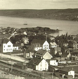
Harbour Grace is a town in Conception Bay on the Avalon Peninsula in the province of Newfoundland and Labrador, Canada. With roots dating back to the 16th century, it is one of the oldest towns in North America.

Brigus South is a local service district and designated place in the Canadian province of Newfoundland and Labrador on the Avalon Peninsula.

<span class="mw-page-title-main">Anchor Point, Newfoundland and Labrador</span> Town in Newfoundland and Labrador, Canada

Anchor Point is a town located in St. Barbe Bay, south of Flower's Cove on the west side of the Great Northern Peninsula, in Newfoundland and Labrador, Canada. It was the first English settlement on what is called the 'French Shore' of Newfoundland.

<span class="mw-page-title-main">Pool's Cove</span> Town in Newfoundland and Labrador, Canada

Pool's Cove is a community located on the north west side of Fortune Bay, on the South Coast of Newfoundland, Canada. The town had a population of 143 in the 2021 Census.

The Bonavista Peninsula is a large peninsula on the east coast of the island of Newfoundland in the Canadian province of Newfoundland and Labrador. It consists of 50 incorporated towns/unincorporated communities which have a population of 12,176 as of the 2016 Canadian Census. Bonavista is the largest population centre on the peninsula.

Musgrave Harbour is a town in the Canadian province of Newfoundland and Labrador.

New-Wes-Valley is a municipality in Newfoundland and Labrador, Canada.

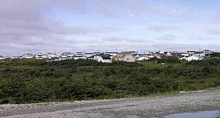
Deadman's Bay is a local service district and designated place in the Canadian province of Newfoundland and Labrador. It is on the Straight Shore of Bonavista Bay near the community of Lumsden. The community is located near fishing grounds, contributing to its diversified and successful fishery despite its exposed, sandy coastline and harsh fall storms.

<span class="mw-page-title-main">Lumsden, Newfoundland and Labrador</span> Town in Newfoundland and Labrador, Canada

Lumsden, formerly known as Cat Harbour, is a community located on the Straight Shore of Newfoundland in Newfoundland and Labrador, Canada, near communities such as Musgrave Harbour and Newtown. Lumsden formerly consisted of two settlements, Lumsden North on the tip of a sandy peninsula and Lumsden South on the main road. Although the harbour in Lumsden is not ideal because it is not sheltered, Lumsden has excellent fishing grounds.

<span class="mw-page-title-main">Elliston, Newfoundland and Labrador</span> Town in Newfoundland and Labrador, Canada

Elliston is an incorporated fishing settlement situated on the Bonavista Peninsula of Newfoundland, Canada. Incorporated in 1965, the town of Elliston was once called Bird Island Cove and it is composed of a number of communities, North Side, Noder Cover, Elliston Centre, Elliston Point, Porter's Point, Sandy Cove, The Neck and Maberly. Elliston is known as the Root Cellar Capital of the World and has claimed that title from the 135 root cellars that exist in the community.

<span class="mw-page-title-main">Salvage, Newfoundland and Labrador</span> Town in Newfoundland and Labrador, Canada

Salvage is a town located on the Eastport Peninsula of the Canadian province of Newfoundland and Labrador. The town had a population of 108 in the Canada 2021 Census.

Sandringham is a town on the Eastport Peninsula in Bonavista Bay North in the Canadian province of Newfoundland and Labrador, Canada. The town had a population of 205 in the Canada 2021 Census.

<span class="mw-page-title-main">Birchy Cove</span>

Birchy Cove is a local service district and designated place in the Canadian province of Newfoundland and Labrador.

<span class="mw-page-title-main">Newfoundland (island)</span> Island portion of Newfoundland and Labrador, Canada

Newfoundland is a large island situated off the eastern coast of the North American mainland and the western part of the Canadian province of Newfoundland and Labrador, referred to as Labrador.

References

  1. 1 2 3 4 5 "Bonavista, T [Census subdivision], Newfoundland and Labrador and Division No. 7, CDR [Census division], Newfoundland and Labrador (table) Census Profile". 2016 census . Statistics Canada. 8 February 2017. Archived from the original on 29 July 2020. Retrieved 9 October 2017.
  2. "Bonavista". The Canadian Encyclopedia. Historica Foundation of Canada. Archived from the original on 5 May 2010. Retrieved 17 July 2011.
  3. Whiffen, Bruce, Prime Berth: An Account of Bonavista's Early Years. Harry Cuff Publications Limited, St John's, A1C 2H2. 1993. ISBN   0-921191-82-0. page 4: "There are no contemporary documents to directly support this story."
  4. John Day's letter to Columbus, quoted in Whiffen, op. cit. page 6.
  5. John Day's letter, as above.
  6. "The International Fishery of the 16th Century". Newfoundland and Labrador Heritage Web Site Project, Memorial University of Newfoundland. 1997. Archived from the original on 26 January 2008. Retrieved 26 January 2008.
  7. Bernard Ransom (1991). "Museum Notes: A Century of Armed Conflict in Newfoundland". The Rooms, Newfoundland Provincial Museum. Archived from the original on 3 March 2008. Retrieved 26 January 2008.
  8. J.K. Hiller (2001). "The French Treaty Shore". Newfoundland and Labrador Heritage Web Site Project, Memorial University of Newfoundland. Archived from the original on 26 January 2021. Retrieved 26 January 2008.
  9. Fishery Products International
  10. Paul Haavardsrud (26 February 2023). "The Holy Grail for the EV Revolution". The Cost of Living (Podcast). CBC Radio One. Event occurs at 2:30. Archived from the original on 1 March 2023. Retrieved 1 March 2023.
  11. "Population and dwelling counts". Statistics Canada. 2006. Archived from the original on 10 October 2017. Retrieved 15 July 2009.
  12. "1976 Census of Canada. Volume 1, Population, geographic distributions" (PDF). Statistics Canada. 1977. Archived (PDF) from the original on 23 November 2022. Retrieved 9 April 2023.
  13. "Population and dwelling counts: Canada, provinces and territories, census divisions and census subdivisions (municipalities), Newfoundland and Labrador". Statistics Canada. 9 February 2022. Archived from the original on 30 April 2022. Retrieved 15 March 2022.
  14. 1 2 "Canadian Climate Normals 1981-2010 Station Data". Environment and Climate Change Canada. 25 September 2013. Archived from the original on 28 January 2022. Retrieved 17 August 2019.