Conception Harbour is a town on the Avalon Peninsula in Newfoundland and Labrador, Canada. It is in Division 1 on Conception Bay and can be accessed via Newfoundland and Labrador Route 60.

Fogo Island is the largest of the offshore islands of Newfoundland and Labrador, Canada. The Town of Fogo Island encompasses Fogo, Joe Batt's Arm-Barr'd Islands-Shoal Bay, Seldom-Little Seldom and Tilting, with the unincorporated areas of Fogo Island. It lies off the northeast coast of Newfoundland, northwest of Musgrave Harbour across Hamilton Sound, just east of the Change Islands. The island is about 25 km (16 mi) long and 14 km (8.7 mi) wide. The total area is 237.71 km2 (91.78 sq mi).

Marystown is a town in the province of Newfoundland and Labrador, Canada, with a population of around 5,000. Situated 306 km from the province's capital, St. John's, it is on the Burin Peninsula. Until the early 1990s, its economy was largely based on shipbuilding, and it is due in part to this that the town experienced a population increase of 295% in just over a decade. The town was also dependent on the fish plant for employment.

Grates Cove is a local service district and designated place in the Canadian province of Newfoundland and Labrador. It is the most northerly community on the Avalon Peninsula, located on the tip of the Bay de Verde Peninsula on the island of Newfoundland. Called "the Grates" by John Guy as early as 1612, the origin of the name is unknown.

St. George's is a Canadian community in the St. George's Bay on the southwest coast of Newfoundland of the province of Newfoundland and Labrador.

Trinity is a small town located on Trinity Bay in Newfoundland and Labrador. The town contains a number of buildings recognized as Registered Heritage Structures by the Heritage Foundation of Newfoundland and Labrador.

Harbour Breton is a small fishing community on the Connaigre Peninsula in Fortune Bay, on the south coast of the island of Newfoundland in Canada. It is the largest center on the Connaigre Peninsula and was long considered the unofficial capital of Fortune Bay. During the 1960s many communities were resettled into Harbour Breton. Harbour Breton is the only administrative centre in Fortune Bay and is located approximately 220 kilometres (140 mi) south of Grand Falls-Windsor.

Gaultois is a small settlement in the Coast of Bays area in Newfoundland and Labrador, Canada. Gaultois had a population of 100 people in the 2021 census. The town has a K-12 school called Victoria Academy, as well as a fire department, public library, Lion's Club, and town hall. The town is only accessible by ferry or helicopter. The provincial government ferry runs from the nearby town of Hermitage several times daily and the crossing takes approximately 20 minutes. This ferry also services the more remote community of McCallum once to twice daily with a crossing time of around one hour and fifteen minutes. In 2015, Gaultois voted against resettlement. Gaultois considered resettlement again in 2023 but it failed.
The Bonavista Peninsula is a large peninsula on the east coast of the island of Newfoundland in the Canadian province of Newfoundland and Labrador. It consists of 50 incorporated towns/unincorporated communities which have a population of 12,176 as of the 2016 Canadian Census. Bonavista is the largest population centre on the peninsula.
Smith Sound is a zigzag 24 kilometre inner region of Trinity Bay. This sound is one of the longest portions of inshore waterways in Newfoundland, located on its north-eastern coast in the Canadian province of Newfoundland and Labrador. Bonavista Peninsula is to the north of the sound, while Random Island is to the south. The waters that make up the sound is a continuous channel that encircles Random Island, broken only by a narrow channel located at Clarenville where a causeway was built to provide access to the communities on Random Island. The channel on the south side of Random Island is North West Arm.
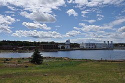
Catalina is a community located on the eastern side of the Bonavista Peninsula, in the province of Newfoundland and Labrador, Canada. Catalina adjoins the union town of Port Union, the town built for and home to the Fisherman's Union Company established by Sir William Coaker.

Cox's Cove is a town in the Canadian province of Newfoundland and Labrador. The town had a population of 664 in the Canada 2021 Census. The small community is mainly based on the fishery, mink farm, and construction industries.

Salvage is a town located on the Eastport Peninsula of the Canadian province of Newfoundland and Labrador. The town had a population of 108 in the Canada 2021 Census.
Trinity Bay North is a town in the Canadian province of Newfoundland and Labrador. It is located at the northern tip of Trinity Bay. The town had a population of 1,649 in the Canada 2021 Census.
The Fish, Food and Allied Workers Union (FFAW) is a trade union in Newfoundland and Labrador that represents 15,000 workers. Most of the members are in the fishing industry but the FFAW also has organized workers in the hotel, hospitality, brewing, metal fabrication, window manufacturing and oil industries in the province. The FFAW is the largest private-sector union in Newfoundland and is affiliated with Unifor.

The Fishermen's Protective Union was a workers' organisation and political party in the Dominion of Newfoundland. The development of the FPU mirrored that of the United Farmers movement in parts of Canada.
Blaketown is a local service district and designated place in the Canadian province of Newfoundland and Labrador.
Black Tickle is a settlement and designated place in Newfoundland and Labrador, located on the Island of Ponds and part of the unrecognized NunatuKavut territory. In the 2021 census Black Tickle had a population of 87. Locations in Labrador south of Black Tickle generally observe Newfoundland Time instead of Atlantic Standard Time, which is observed by the rest of the province's continental communities. Black Tickle is inaccessible by road and is served by Black Tickle Airport, a gravel strip airport (CCE4).
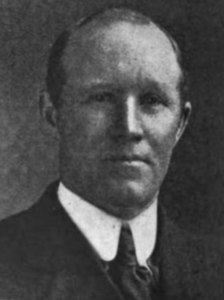
John Glover Stone was a boat builder, merchant and politician in Newfoundland. He represented Trinity from 1913 to 1919 and Trinity North from 1932 to 1934 in the Newfoundland House of Assembly.

Division No. 1, Subdivision G is an unorganized subdivision on the Avalon Peninsula in Newfoundland and Labrador, Canada. It is in Division 1 and contains the unincorporated communities of Baccalieu Island, Besom Cove, Bradley's Cove, Burnt Point, Caplin Cove, Daniel's Cove, Grates Cove, Gull Island, Job's Cove, Kingston, Long Beach, Lower Island Cove, Low Point, Northern Bay, Ochre Pit Cove, Red Head Cove, Riverhead, Smooth Cove and Western Bay.