Fortune, Newfoundland and Labrador

Last updated

Fortune
Town
Fortune marina - panoramio (2).jpg
Flag of Fortune, Newfoundland and Labrador.svg
Fortuneseal.jpg
Motto: 
Progressa Fortuna
Canada Newfoundland location map.svg
Red pog.svg
Fortune
Location of Fortune in Newfoundland
Coordinates: 47°04′24″N55°49′18″W / 47.07333°N 55.82167°W / 47.07333; -55.82167
Country Flag of Canada (Pantone).svg  Canada
Province Flag of Newfoundland and Labrador.svg  Newfoundland and Labrador
Incorporated1945
Government
  MayorDeanne Hickman
Area
  Total54.85 km2 (21.18 sq mi)
Population
 (2021)
  Total1,285 [1]
  Density25.5/km2 (66/sq mi)
Time zone UTC-3:30 (Newfoundland Time)
  Summer (DST) UTC-2:30 (Newfoundland Daylight)
Area code 709
Highways NL Route 220.svg Route 220
Website

Fortune (2021 population: 1,285) [1] is a Canadian town located in the province of Newfoundland and Labrador.

Contents

Fortune is situated on the western side of the Burin Peninsula on the island of Newfoundland and was incorporated as a town in 1945. The town is located near the southeastern boundary of Fortune Bay. The name of the town is believed to have originated from the Portuguese word "fortuna" meaning "harbour of good fortune."

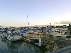
The main industry in Fortune is the ocean fishery which employs 400 residents. The majority of species landed include cod, flounder, and haddock.

Fortune is also the nearest Canadian port for travelling to the French islands of St. Pierre and Miquelon. During the spring and summer months, a ferry connects the two islands with Fortune.

The Geological stage Fortunian - the first age of the Cambrian Period - is named after Fortune and Fortune Bay. The GSSP is nearby.

Demographics

In the 2021 Census of Population conducted by Statistics Canada, Fortune had a population of 1,285 living in 617 of its 767 total private dwellings, a change of

Notable people

Related Research Articles

<span class="mw-page-title-main">Belleoram</span> Town in Newfoundland and Labrador, Canada

Belleoram is a village on the shores of Fortune Bay in the Canadian province of Newfoundland and Labrador.

<span class="mw-page-title-main">Peterview</span> Town in Newfoundland and Labrador, Canada

Peterview is a town located in the Exploits Valley area of central Newfoundland and Labrador, Canada, where Peters River empties into the Bay of Exploits, just south of Botwood, off Route 350.

Garnish, a town located on the west coast of the Burin Peninsula, was well known for its lumbering and now for its lobstering operations. Located on Route 213, it is 25 km along route 220 north west of Grand Bank and 18 km along Route 220 east of Marystown. The Way Office was established in 1852 and the first Waymaster was Henry Campe. In 2021, the town had a population of 542.

Hermitage-Sandyville is a small town on the south coast of Newfoundland, Canada, with a population of 404 people in the 2021 Census. The main source of income for the community is provided by the aquaculture industry, the local salmon plant and fishing.

Epworth-Great Salmonier is a local service district and designated place in the Canadian province of Newfoundland and Labrador. It is on the Burin Peninsula of the island of Newfoundland.

Colinet is an incorporated town located on the northwest arm of St. Mary's Bay in Newfoundland and Labrador, Canada.

Admirals Beach is a rural community located in Newfoundland and Labrador, Canada.

<span class="mw-page-title-main">Leading Tickles</span> Town in Newfoundland and Labrador, Canada

Leading Tickles is a town in the Canadian province of Newfoundland and Labrador. In 2021, the town had a population of 296, down from 407 in the Canada 2006 Census. It is located approximately 25 km Northwest of Point Leamington on the shores of Notre Dame Bay. The town boasts spectacular scenery especially in spring and early summer when many icebergs pass just off the coast.

Miles Cove is a town on Sunday Cove Island in the Canadian province of Newfoundland and Labrador. The town had a population of 104 in 2016, down from 140 in the Canada 2006 Census.

Morrisville is a town in the Canadian province of Newfoundland and Labrador. The town had a population of 93 in the Canada 2021 Census. Morrisville is located in the Bay d'Espoir region and is 169 km from Grand Falls-Windsor.

Mount Moriah is a town in the Canadian province of Newfoundland and Labrador. The town had a population of 700 in the Canada 2021 Census.

Point of Bay is a town in the Canadian province of Newfoundland and Labrador. The town had a population of 154 people in 2016, down from 163 in the Canada 2006 Census.

St. Joseph's is a town in the Canadian province of Newfoundland and Labrador. It is located on the Avalon Peninsula, approximately 70 kilometres southwest of St. John's, and near St. Mary's Bay.

<span class="mw-page-title-main">Whiteway, Newfoundland and Labrador</span> Town in Newfoundland and Labrador, Canada

Whiteway is a town in the Canadian province of Newfoundland and Labrador. The town had a population of 351 in the Canada 2021 Census.

Milltown–Head of Bay d'Espoir is a town in the Canadian province of Newfoundland and Labrador. The town had a population of 669 in the Canada 2021 Census.

<span class="mw-page-title-main">St. Jacques-Coomb's Cove</span> Town in Newfoundland and Labrador, Canada

St. Jacques-Coomb's Cove is a town in the Canadian province of Newfoundland and Labrador. The town had a population of 546 in the Canada 2021 Census. It is located on the south coast of the island of Newfoundland on the north side of Fortune Bay, on the southern tip of the Connaigre Peninsula in what is now known as the Coast of Bays Region. The town consists of six communities, St. Jacques, English Harbour West, Mose Ambrose, Boxey, Coomb's Cove, and Wreck Cove, all nestled within the inlets along the coast. They all had their beginnings in the fisheries and the fisheries have always been the mainstay of employment in the communities. In recent years aquaculture was introduced in the area, providing employment for its residents.

<span class="mw-page-title-main">St. Lunaire-Griquet</span> Town in Newfoundland and Labrador, Canada

St. Lunaire-Griquet is a town in the Canadian province of Newfoundland and Labrador. The town is located near the northern tip of the Great Northern Peninsula of Newfoundland. The town had a population of 603 in the Canada 2021 Census.

Seal Cove is a town in the Canadian province of Newfoundland and Labrador, located on Fortune Bay. The town had a population of 100 in the 2021 Census. The population of Seal Cove, Fortune Bay has fallen to approximately 100 largely due to outmigration for education and other work-related pursuits. The town was incorporated in 1972.

Fortune Harbour or Fortune Harbor is a designated place in the Canadian province of Newfoundland and Labrador.

Grand Beach is a designated place in the Canadian province of Newfoundland and Labrador. It is on the Burin Peninsula of the island of Newfoundland.

References

  1. 1 2 "Census Profile, 2016 Census". Statistics Canada. 2017-04-14. Retrieved 2017-05-07.
  2. "Population and dwelling counts: Canada, provinces and territories, census divisions and census subdivisions (municipalities), Newfoundland and Labrador". Statistics Canada. February 9, 2022. Retrieved March 15, 2022.

47°04′24″N55°49′18″W / 47.07333°N 55.82167°W / 47.07333; -55.82167 (Fortune)