Southern Harbour

Last updated
Southern Harbour
Town
Southern Harbour, Newfoundland, Canada.jpg
Canada Newfoundland location map.svg
Red pog.svg
Southern Harbour
Location of Southern Harbour in Newfoundland
Coordinates: 47°43′20″N53°57′12″W / 47.72222°N 53.95333°W / 47.72222; -53.95333
Country Flag of Canada (Pantone).svg  Canada
Province Flag of Newfoundland and Labrador.svg  Newfoundland and Labrador
Population
 (2021)
  Total313
Time zone UTC-3:30 (Newfoundland Time)
  Summer (DST) UTC-2:30 (Newfoundland Daylight)
Area code(s) 709
Highways NL TCH sign.svg Route 1 (TCH)

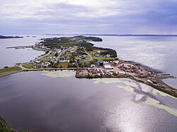
Southern Harbour is a town in the province of Newfoundland and Labrador, Canada. The town had a population of 369 in the Canada 2016 Census.

Contents

Demographics

In the 2021 Census of Population conducted by Statistics Canada, Southern Harbour had a population of 313 living in 152 of its 209 total private dwellings, a change of

See also

Related Research Articles

Conception Harbour is a town on the Avalon Peninsula in Newfoundland and Labrador, Canada. It is in Division 1 on Conception Bay.

Colliers is a town on the Avalon Peninsula in Newfoundland and Labrador, Canada. It is in Division 1 on Conception Bay.

Whitbourne is a town on the Avalon Peninsula in Newfoundland and Labrador, Canada in Division 1.

Chapel Arm is a settlement in Newfoundland, Canada, located at the southeast corner of Trinity Bay, approximately 100 km (62 mi) west of St. John's and two km from the Trans-Canada Highway.

Sandy Cove, Newfoundland and Labrador Town in Newfoundland and Labrador, Canada

Sandy Cove is a town located on the Eastport Peninsula in Newfoundland and Labrador, Canada. It is located on Newman Sound, which is part of Bonavista Bay. It had a population of 122 in the 2016 census

Baine Harbour Town in Newfoundland and Labrador, Canada

Baine Harbour is a Canadian community in the province of Newfoundland and Labrador northeast of Marystown.

Red Harbour is a Canadian municipality of Newfoundland and Labrador. It is located 20 kilometres northeast of Marystown.

Small Point-Adams Cove-Blackhead-Broad Cove Town in Newfoundland and Labrador, Canada

Small Point-Adam's Cove-Blackhead-Broad Cove is a town in the Canadian province of Newfoundland and Labrador, located in the Trinity-Conception Bay District north of Carbonear.

Admirals Beach is a rural community located in Newfoundland and Labrador, Canada.

Duntara is a town located north west of Catalina, Newfoundland and Labrador. Duntara was an Incorporated Community on October 21, 1961.

Chance Cove is a town in the Canadian province of Newfoundland and Labrador. The town had a population of 213 in the Canada 2021 Census.

Heart's Desire is a town in the Canadian province of Newfoundland and Labrador. The town had a population of 226 in the Canada 2006 Census.

Little Bay East is a town in the Canadian province of Newfoundland and Labrador. The town had a population of 84 in the Canada 2021 Census.

Port Rexton is a small town in the Canadian province of Newfoundland and Labrador. It is located on the East Coast of the island of Newfoundland at the north end of Robinhood Bay, about 10 minutes east of Trinity and 3 hours north of St. John's. The town had a population of 690 in 1940, 449 in 1951, 454 in 1956, 351 in the Canada 2006 Census, 338 in the Canada 2011 Census and most recently 340 in the Canada 2016 Census. The town is part of a group of communities known as the Trinity Bight. The town is home to a few small businesses, including inns and restaurants as well as the Skerwink trail which connects Port Rexton to Trinity Harbour.

Salmon Cove is a town in the Canadian province of Newfoundland and Labrador. The town had a population of 764 in the Canada 2021 Census, up from 695 in 2016.

St. Joseph's is a town in the Canadian province of Newfoundland and Labrador. It is located on the Avalon Peninsula, approximately 70 kilometres southwest of St. John's, and near St. Mary's Bay.

Mount Carmel-Mitchells Brook-St. Catherines is a town in the Canadian province of Newfoundland and Labrador. The town had a population of 358 in the Canada 2011 Census.

Norman's Cove-Long Cove is a town in the Canadian province of Newfoundland and Labrador. The town had a population of 666 in the Canada 2016 Census, down from 720 in 2011.

St. Jacques-Coombs Cove Town in Newfoundland and Labrador, Canada

St. Jacques-Coomb's Cove is a town in the Canadian province of Newfoundland and Labrador. The town had a population of 546 in the Canada 2021 Census. It is located on the south coast of the island of Newfoundland on the north side of Fortune Bay, on the southern tip of the Connaigre Peninsula in what is now known as the Coast of Bays Region. The town consists of six communities, St. Jacques, English Harbour West, Mose Ambrose, Boxey, Coomb's Cove, and Wreck Cove, all nestled within the inlets along the coast. They all had their beginnings in the fisheries and the fisheries have always been the mainstay of employment in the communities. In recent years aquaculture was introduced in the area, providing employment for its residents.

Old Shop is a local service district and designated place in the Canadian province of Newfoundland and Labrador. It is on the western side of the Dildo Arm, at the southern end of Trinity Bay. It is northwest of South Dildo, across the Dildo Arm from Dildo proper.

References

  1. "Population and dwelling counts: Canada, provinces and territories, census divisions and census subdivisions (municipalities), Newfoundland and Labrador". Statistics Canada. February 9, 2022. Retrieved March 15, 2022.

Coordinates: 47°43′20″N53°57′12″W / 47.72222°N 53.95333°W / 47.72222; -53.95333