Division No. 1, Subdivision A is an unorganized subdivision on the Avalon Peninsula in Newfoundland and Labrador, Canada. It is in Division No. 1, and lies between Trinity Bay and Placentia Bay.

Arnold's Cove is a town on Newfoundland's Avalon Peninsula in the province of Newfoundland and Labrador, Canada. It is in Division 1 on Placentia Bay.

Division 1, Newfoundland and Labrador is a census division covering the entire Avalon Peninsula including the Isthmus of Avalon of the Canadian province of Newfoundland and Labrador. Like all census divisions in Newfoundland and Labrador, but unlike the census divisions of some other provinces, the division exists only as a statistical division for census data, and is not a political entity.

Avalon is a federal electoral district on Newfoundland Island in Newfoundland and Labrador, Canada. It has been represented in the House of Commons of Canada since 2004.

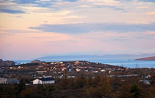
Placentia is a town located in the Canadian province of Newfoundland and Labrador. It consists of the Argentia Industrial Park and amalgamated communities of Townside, Freshwater, Dunville, Southeast, Point Verde and Jerseyside.

Placentia—St. Mary's is a provincial electoral district for the House of Assembly of Newfoundland and Labrador, Canada. As of 2011, there were 7,361 eligible voters living within the district.
The Burin Peninsula is a peninsula located on the south coast of the island of Newfoundland in the province of Newfoundland and Labrador. Marystown is the largest population centre on the peninsula.
Port de Grave is a peninsula on Conception Bay (CB) in Newfoundland and Labrador, Canada. The peninsula contains the communities of Bareneed, Black Duck Pond, Otterbury, Ship Cove, Blow Me Down, Hibb's Cove, Pick Eyes, and Hussey's Cove with a population of approximately 975 (2006). This community is located in the provincial electoral district of Port de Grave. An unincorporated area, for statistics purposes it is called Division No. 1, Subdivision L. The Peninsula is accessible by road via Route 72.

Argentia is a Canadian commercial seaport and industrial park located in the Town of Placentia, Newfoundland and Labrador. It is situated on the southwest coast of the Avalon Peninsula and defined by a triangular shaped headland which reaches northward out into Placentia Bay creating a natural harbour 3 km (1.9 mi) in length.
Bay de Verde is an incorporated town in Conception Bay on the northern tip of the Bay de Verde Peninsula of Newfoundland and Labrador, Canada. The first recorded inhabitants at Bay de Verde arrived in 1662. Bay de Verde became an incorporated town in 1950.
Bay Roberts is located on the north shore of Conception Bay on the northeastern Avalon Peninsula in the province of Newfoundland and Labrador, Canada. The growth of the local economy can be connected to the town's proximity to other major Newfoundland markets, by road and by water.

Fox Harbour is a small community on the Avalon Peninsula of Newfoundland. According to Statistics Canada in 2011, the population was 270. It is surrounded by hills. It is located close to Argentia, the site of the Naval Station Argentia. According to some sources, Fox Harbour got its name from tales of foxes that came down from the surrounding hills and ate the drying fish on the flakes. As well, the community was called Little Glocester before it became officially named Fox Harbour.
Ship Harbour is a community in Newfoundland and Labrador, Canada located on the eastern shore of Placentia Bay.
Shearstown is a settlement in Newfoundland and Labrador. It is part of the Town of Bay Roberts. Shearstown Brook runs through the community to the Shearstown Estuary, then flowing into Spaniard's Bay. The brook valley consists largely of terraced sand and gravel deposits, likely deposited in an ice-distal glaciofluvial environment.
Division No. 1, Subdivision B is an unorganized subdivision on the Avalon Peninsula in Newfoundland and Labrador, Canada. It is in Division 1 and contains the unorganized communities of Iona, Little Barasway, Placentia Junction, Point Verde and Ship Harbour.
Division No. 1, Subdivision C is an unorganized subdivision on the Avalon Peninsula in Newfoundland and Labrador, Canada. It is in Division 1 and contains the unincorporated communities of Cape St. Mary's, Cuslett, Gooseberry Cove, Great Barasway, Lears Cove, Patrick's Cove-Angels Cove, Ship Cove and Stoney House.
Long Island is a long narrow island located in the inner portion of Placentia Bay. The longest axis of the island lies in a north-south direction. It is approximately 24 kilometres long and just over 3 kilometres at its widest point. Long Island along with Merasheen Island and Red Island make up the majority of the islands in Placentia Bay. Long Island is located approximately 22 kilometres northwest of Argentia. It is separated from Merasheen Island to the west by a 24 kilometre long channel that narrows to within 2.12 kilometres. Red Island is approximately 10 kilometres to the southwest of Long Island.
Route 100 is a major highway in Newfoundland and Labrador. The highway begins at its northern terminus at the Trans-Canada Highway in the town of Whitbourne, runs for 108 kilometres (67 mi) until it ends at its southern terminus, the town of Branch, where it transitions into Route 92. Motorists can drive along the coast of Placentia Bay and eventually the Atlantic Ocean once traveling south of Point Verde.
Iona was a small community in Placentia Bay, Newfoundland and Labrador made up of small islands that used to be inhabited. The islands were once called The Ram's or Ram's Islands.

Little Placentia Sound is an abandoned town in Newfoundland and Labrador that had a peak population of 47 in 1901. It is named after the body of water (sound) that encompasses the former community located within Placentia Bay on the Avalon Peninsula in the Canadian province of Newfoundland and Labrador. There was once a lead mine called Silver Cliff Mine located within the town.


