Sunnyside, Newfoundland and Labrador

Last updated

Sunnyside
Town
Sunnyside, Newfoundland, Centre Cove.jpg
Canada Newfoundland location map.svg
Red pog.svg
Sunnyside
Location of Sunnyside in Newfoundland
Coordinates: 47°52′N53°56′W / 47.867°N 53.933°W / 47.867; -53.933
Country Flag of Canada (Pantone).svg  Canada
Province Flag of Newfoundland and Labrador.svg  Newfoundland and Labrador
Census division 1
Area
  Total37.95 km2 (14.65 sq mi)
Population
 (2021)
  Total407
  Density10.0/km2 (26/sq mi)
Time zone UTC-3:30 (Newfoundland Time)
  Summer (DST) UTC-2:30 (Newfoundland Daylight)
Area code 709
Highways NL TCH sign.svg Route 1 (TCH)

Sunnyside is a town on the Avalon Peninsula in Newfoundland and Labrador, Canada. It is in Division 1 on Bull Arm.

Contents

History

Early history

The town of Sunnyside stretches for about five miles along the shore of Trinity Bay, also known as Bull Arm. Sunnyside is believed to have been once inhabited by the native people of Newfoundland known as the Beothuk, discovered by the explorer John Guy. After a few hundred years, the area was settled by the ancestors, of many of the families living there today. Those families were involved in developing the economy of Sunnyside by beginning the fishery, logging, and mining industries in the community. With the creation of those industries, the population has increased over the years resulting in Sunnyside as it is known today.

The USS Niagara landed the first successful Transatlantic Telegraph Cable here in Sunnyside on August 5, 1858. Sunnyside was then Known as "Bay Bulls Arm. [1] During the period in which the cable operated, between Aug 9 and October 20, 1858, 732 messages were sent through the cable station here in Sunnyside. One of the first official messages sent was a congratulatory message from Queen Victoria to US President James Buchanan on the success of the First Transatlantic Cable.

Before the town of Sunnyside was even settled, explorer John Guy, in the year of 1612, "to the north near the present Sunnyside he found a group of natives…" (Rockwood, 1992) According to the Newfoundland and Labrador Heritage website, "The Beothuks are the aboriginal people of the island of Newfoundland. They were Algonkian-speaking hunter-gatherers who probably numbered less than a thousand people at the time of European contact." (Pastore, 1997) Prior to the area being known as Sunnyside, John Guy had named the area Truce Sound in honour of the good relations established with the Beothuk.

As the area was first settled, it was known as Bottom of Bay Bulls Arm. There were other related settlements nearby like Centre Cove. The area was known as Bay Bulls Arm for some time and then changed to Bull Arm. The reason for the change was likely due to the fact that there is another town known as Bay Bulls. The first permanent settlers to the community were the Snooks from the nearby community of New Perlican. The current name of Sunnyside came from a former school teacher who said "…the spot of sun which seems always to shine on that tiny section of Trinity Bay."(Rockwood, 1992)

19th century to present

By the mid 19th century, the community was made up of full fisherman and loggers. During that time, working in the saw-mill was an important job but due to a fire in the community, most of the standing timber was destroyed. The pulpwood drive was also an important form of employment and Morgan Snook was the foreman of the Main River and Badger drive. Fishing was a small part of the economy, but people from other Trinity Bay communities came to Bay Bulls Arm to fish.

"In 1921, the population had reached 337, and the town name had officially been changed to Sunnyside." (Hike Discovery, para. 3) By the 1930s the population in the community had reached its peak of 399 citizens. The population by the 1950s had declined to 228 people. After that time, the population grew steadily over the years until reaching a high population of 726, later decreasing to 634 by 1986.

Over the years many of the citizens of Sunnyside could be found in road construction and other large construction projects. The oil refinery, located in Come By Chance, is a source of employment for many Sunnyside residents. Along with the oil refinery, many of the residents were once employed by working on the Hibernia Oil Platform project, which was located right in their own backyards. "One of the five super modules, the wellhead module, was built at the Bull Arm construction site in Newfoundland. The other four super modules were constructed outside Canada (two in Italy and two in Korea) and shipped to Bull Arm in May and June of 1995 where they were welded together to form one integrated unit." (Hibernia, para. 10)

Demographics

In the 2021 Census of Population conducted by Statistics Canada, Sunnyside had a population of 407 living in 189 of its 271 total private dwellings, a change of

See also

Related Research Articles

<span class="mw-page-title-main">Dildo, Newfoundland and Labrador</span> Local service district / designated place in Newfoundland and Labrador, Canada

Dildo is a local service district and designated place in the Canadian province of Newfoundland and Labrador on the island of Newfoundland. It is located on the southeastern Dildo Arm of Trinity Bay about 100 kilometres (62 mi) west of St. John's. South Dildo is a community located to the south, and in 2021 had 195 residents. It is known for its unusual name.

<span class="mw-page-title-main">Beothuk</span> Indigenous people of Newfoundland

The Beothuk were a group of indigenous people who lived on the island of Newfoundland.

<span class="mw-page-title-main">Fogo Island (Newfoundland and Labrador)</span> Island of Newfoundland and Labrador, Canada

Fogo Island is the largest of the offshore islands of Newfoundland and Labrador, Canada. The Town of Fogo Island encompasses Fogo, Joe Batt's Arm-Barr'd Islands-Shoal Bay, Seldom-Little Seldom and Tilting, with the unincorporated areas of Fogo Island. It lies off the northeast coast of Newfoundland, northwest of Musgrave Harbour across Hamilton Sound, just east of the Change Islands. The island is about 25 km (16 mi) long and 14 km (8.7 mi) wide. The total area is 237.71 km2 (91.78 sq mi).

Cuper's Cove, on the southwest shore of Conception Bay on Newfoundland's Avalon Peninsula was an early English settlement in the New World, and the third one after Harbour Grace, Newfoundland (1583) and Jamestown, Virginia (1607) to endure for longer than a year. It was established in 1610 by John Guy on behalf of Bristol's Society of Merchant Venturers, who had been given a charter by King James I of England to establish a colony on the island of Newfoundland. Most of the settlers left in the 1620s, but apparently a few stayed on and the site was continuously inhabited.

<span class="mw-page-title-main">Division No. 1, Newfoundland and Labrador</span> Census division in Newfoundland and Labrador, Canada

Division 1, Newfoundland and Labrador is a census division covering the entire Avalon Peninsula including the Isthmus of Avalon of the Canadian province of Newfoundland and Labrador. Like all census divisions in Newfoundland and Labrador, but unlike the census divisions of some other provinces, the division exists only as a statistical division for census data, and is not a political entity.

<span class="mw-page-title-main">Shanawdithit</span> Beothuk woman

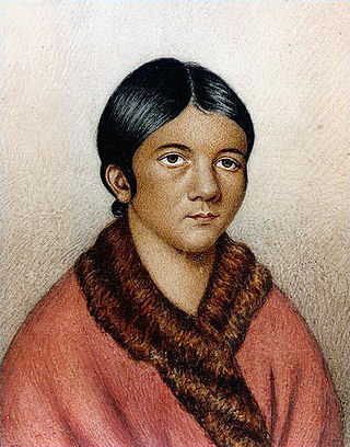
Shanawdithit, also noted as Shawnadithit, Shawnawdithit, Nancy April and Nancy Shanawdithit, was the last known living member of the Beothuk people, who inhabited Newfoundland, Canada. Remembered for her contributions to the historical understanding of Beothuk culture, including drawings depicting interactions with European settlers, Shanawdithit died of tuberculosis in St. John's, Newfoundland on June 6, 1829.

<span class="mw-page-title-main">Twillingate</span> Place in Newfoundland and Labrador, Canada

Twillingate is a town of 2,121 people located on the Twillingate Islands ("Toulinquet") in Notre Dame Bay, off the north eastern shore of the island of Newfoundland in the province of Newfoundland and Labrador, Canada. The town is about 100 kilometres (62 mi) north of Lewisporte and Gander.

<span class="mw-page-title-main">Heart's Content, Newfoundland and Labrador</span> Town in Newfoundland and Labrador, Canada

Heart's Content is an incorporated town in Trinity Bay on the Bay de Verde Peninsula of Newfoundland and Labrador, Canada.

<span class="mw-page-title-main">Boyd's Cove, Newfoundland and Labrador</span> Settlement in Newfoundland, Canada

Boyd's Cove, also known as Boyd's Harbour, is a local service district and designated place in the Canadian province of Newfoundland and Labrador that is near Lewisporte. There is an interpretive centre dedicated to the earlier indigenous Beothuk settlement at this location.

<span class="mw-page-title-main">Peterview</span> Town in Newfoundland and Labrador, Canada

Peterview is a town located in the Exploits Valley area of central Newfoundland and Labrador, Canada, where Peters River empties into the Bay of Exploits, just south of Botwood, off Route 350.

Springdale is a town in Newfoundland and Labrador, Canada, which had a population of 2,965 people in 2021, up from 2,764 in the Canada 2006 Census. The community is located on the Northwestern shores of Hall's Bay in Central Newfoundland, near the mouth of Indian River.

<span class="mw-page-title-main">Campbellton, Newfoundland and Labrador</span> Town in Newfoundland and Labrador, Canada

Campbellton is a small lumbering and fishing community located on the island of Newfoundland at Indian Arm, Notre Dame Bay. The community was originally named Indian Arm due to a Beothuk village located on the nearby Indian Arm River. It was renamed to Campbellton in honor of the sawmill manager John Campbell.

Indian Bay is located in Newfoundland, Canada.

<span class="mw-page-title-main">Birchy Bay</span> Town in Newfoundland and Labrador, Canada

Birchy Bay is a small community found in Notre Dame Bay in the province of Newfoundland and Labrador, Canada.

<span class="mw-page-title-main">Salvage, Newfoundland and Labrador</span> Town in Newfoundland and Labrador, Canada

Salvage is a town located on the Eastport Peninsula of the Canadian province of Newfoundland and Labrador. The town had a population of 108 in the Canada 2021 Census.

Bull Arm is a natural arm of approximately 10 miles in length and average of 1 mile wide located at the Isthmus of Avalon on the Avalon Peninsula in the Canadian province of Newfoundland and Labrador. The inner reaches of the arm is located at Sunnyside, and from there it is a mere 2.72 miles to Placentia Bay at Come by Chance.

<span class="mw-page-title-main">Hibernia Gravity Base Structure</span>

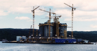
The Hibernia Gravity Base Structure is an offshore oil platform on the Hibernia oilfield southeast of St. John's, Newfoundland, Canada.

<span class="mw-page-title-main">Newfoundland (island)</span> Island portion of Newfoundland and Labrador, Canada

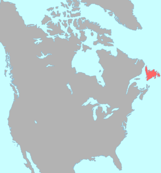
Newfoundland is a large island situated off the eastern coast of the North American mainland and the most populous part of the Canadian province of Newfoundland and Labrador. The island contains 29 percent of the province's land area. The island is separated from the Labrador Peninsula by the Strait of Belle Isle and from Cape Breton Island by the Cabot Strait. It blocks the mouth of the Saint Lawrence River, creating the Gulf of Saint Lawrence, the world's largest estuary. Newfoundland's nearest neighbour is the French overseas collectivity of Saint Pierre and Miquelon.

New Harbour is a local service district and designated place in the Canadian province of Newfoundland and Labrador. It is on the east shore of Trinity Bay, along Provincial Route 80. Route 80's intersection with Route 73 is inside New Harbour.

Milton is a designated place in the Canadian province of Newfoundland and Labrador that is a neighbourhood within the Town of George's Brook-Milton. Originally named King's Cove, it changed its name to Milton in 1910.

References

  1. "History of the Atlantic Cable & Submarine Telegraphy - the 1858 Atlantic Cable Station, Bay Bulls Arm, Newfoundland".
  2. "Population and dwelling counts: Canada, provinces and territories, census divisions and census subdivisions (municipalities), Newfoundland and Labrador". Statistics Canada. February 9, 2022. Retrieved March 15, 2022.

47°52′N53°56′W / 47.867°N 53.933°W / 47.867; -53.933