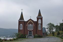
Holyrood is a town on the Avalon Peninsula in Newfoundland and Labrador, Canada. It is in Division 1, on Conception Bay. It is approximately a 30 minute drive from the capital city of St. John's. During King William's War, the village was destroyed in the Avalon Peninsula Campaign.
Harbour Main-Chapel's Cove-Lakeview is a town on the Avalon Peninsula in Newfoundland and Labrador, Canada. It is in Division 1, on Conception Bay. During King William's War, the village was destroyed in the Avalon Peninsula Campaign.
Conception Harbour is a town on the Avalon Peninsula in Newfoundland and Labrador, Canada. It is in Division 1 on Conception Bay.
Colliers is a town on the Avalon Peninsula in Newfoundland and Labrador, Canada. It is in Division 1 on Conception Bay.

Come By Chance is a town on the isthmus of the Avalon Peninsula in Newfoundland and Labrador, Canada. It is in Division 1 on Placentia Bay.

Ferryland is a town in Newfoundland and Labrador on the Avalon Peninsula. According to the 2016 Statistics Canada census, its population is 414.

Division 1, Newfoundland and Labrador is a census division covering the entire Avalon Peninsula including the Isthmus of Avalon of the Canadian province of Newfoundland and Labrador. Like all census divisions in Newfoundland and Labrador, but unlike the census divisions of some other provinces, the division exists only as a statistical division for census data, and is not a political entity.
Port Kirwan is a small incorporated fishing community located on the southern shore of the Avalon Peninsula, Newfoundland, Canada.
Brigus South is a local service district and designated place in the Canadian province of Newfoundland and Labrador on the Avalon Peninsula.
Calvert is a local service district and designated place in the Canadian province of Newfoundland and Labrador in the Southern Shore region of the province. It is 72 kilometres south of the provincial capital St. John's, 7 kilometres south of Cape Broyle, and 3 kilometres north of Ferryland. The population in 2001 was 355, a decline of 17% since 1996.
Mobile is a local service district and designated place in the Canadian province of Newfoundland and Labrador on the Avalon Peninsula.

Petty Harbour–Maddox Cove is a town of approximately 960 people located on the eastern shore of the Avalon Peninsula in the province of Newfoundland and Labrador, Canada. It is nestled deep in the heart of Motion Bay, just south of St. John's. The present town is approximately 200 years old, though the site has been continuously occupied since at least 1598, predating the arrival of the Mayflower and making it one of the oldest European settlements in North America. During King William's War, the village was raided by French forces in the Avalon Peninsula Campaign.
Gaskiers-Point La Haye is a town in Newfoundland and Labrador, Canada, located in St. Mary's Bay. It is located southwest of St. Mary's. It became a local government community in 1970. In 2011, the town had a population of 233.
Aquaforte is a town on the south shore of Newfoundland's Avalon Peninsula in the province of Newfoundland and Labrador, Canada.

Pouch Cove is a town in the Canadian province of Newfoundland and Labrador. The population is 2,069 according to the Canada 2016 Census. It is located on the northeast Avalon Peninsula, 27 kilometres north of St. John's, the province's capital city. The origin of Pouch Cove dates back to 1611, when fisherman from British ships, together with carpenters and other artisans, established a settlement. The town was officially incorporated in 1970. The post office was established in 1975. The Town has a Council consisting of a Mayor, Deputy Mayor, and five councillors. The town's motto is "first to see the sun," referring to the sunrise in North America.
Admirals Beach is a rural community located in Newfoundland and Labrador, Canada.
Bay L'Argent is a town in the Canadian province of Newfoundland and Labrador.
Bishop's Cove is a town in the Canadian province of Newfoundland and Labrador situated in Spaniard's Bay on the Avalon Peninsula.
Portugal Cove South is a small fishing town on the southern shore of the Avalon Peninsula of Newfoundland in the province of Newfoundland and Labrador, Canada. Portugal Cove South had a population of 225 in the Canada 2006 Census, down to 86 in Canada 2021 Census.
St. Joseph's is a town in the Canadian province of Newfoundland and Labrador. It is located on the Avalon Peninsula, approximately 70 kilometres southwest of St. John's, and near St. Mary's Bay.


