Fogo Island, Newfoundland and Labrador

Last updated
Fogo Island
Town
Town of Fogo Island
Fogo Island Inn.jpg
Canada Newfoundland location map.svg
Red pog.svg
Fogo Island
Location of Fogo Island in Newfoundland
Coordinates: 49°39′30″N54°10′57″W / 49.65833°N 54.18250°W / 49.65833; -54.18250 [1] Coordinates: 49°39′30″N54°10′57″W / 49.65833°N 54.18250°W / 49.65833; -54.18250 [2]
CountryCanada
Province Newfoundland and Labrador
Incorporated [3] March 1, 2011
Population
 (2016) [4]
  Total2,244
Time zone UTC-03:30 (NST)
  Summer (DST) UTC-02:30 (NDT)
Area code(s) 709
Highways Ferry Sign.svg MV Veteran
NL Route 333.svg Route 333
NL Route 334.svg Route 334
Website Town of Fogo Island

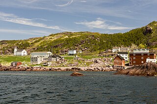
Fogo Island is a town located on Fogo Island, the largest of the offshore islands in the province of Newfoundland and Labrador, Canada.

Contents

History

The Town of Fogo Island was incorporated on March 1, 2011 following the amalgamation of four towns – Fogo, Joe Batt's Arm-Barr'd Islands-Shoal Bay, Seldom-Little Seldom and Tilting – with the unincorporated balance of the Fogo Island. [3]

Demographics

In the 2021 Census of Population conducted by Statistics Canada, Fogo Island had a population of 2,117 living in 964 of its 1,450 total private dwellings, a change of

NameFormer
status
Population
(2016)
Population
(2011)
Per cent
change
(%)
Occupied
dwellings
Private
dwellings
Land
area
(km²)
Population
density
Fogo [6] Town6586580.02893495.92111.2
Joe Batt's Arm-Barr'd Islands-Shoal Bay [6] Town630685-8.028239926.0224.2
Seldom-Little Seldom [7] Town386427-9.615118014.6026.4
Tilting [7] Town173204-15.28415217.639.8
Balance of Fogo Island [8] Unincorporated397421-5.79791,460173.482.3
Fogo Island [8] 2,2442,395-6.39791,460237.659.4

Climate

Climate data for Fogo Island (1981–2010, extremes 1873–2004)
MonthJanFebMarAprMayJunJulAugSepOctNovDecYear
Record high °C (°F)15.5
(59.9)
12.5
(54.5)
18.0
(64.4)
24.0
(75.2)
27.0
(80.6)
29.5
(85.1)
31.5
(88.7)
30.6
(87.1)
28.0
(82.4)
25.0
(77.0)
18.3
(64.9)
15.6
(60.1)
31.5
(88.7)
Average high °C (°F)−3.0
(26.6)
−3.3
(26.1)
−0.2
(31.6)
3.6
(38.5)
9.2
(48.6)
14.3
(57.7)
18.9
(66.0)
19.5
(67.1)
15.3
(59.5)
9.5
(49.1)
4.4
(39.9)
0.6
(33.1)
7.4
(45.3)
Daily mean °C (°F)−5.9
(21.4)
−6.9
(19.6)
−3.5
(25.7)
0.8
(33.4)
5.4
(41.7)
9.9
(49.8)
14.6
(58.3)
15.8
(60.4)
12.1
(53.8)
7.1
(44.8)
2.2
(36.0)
−1.8
(28.8)
4.2
(39.6)
Average low °C (°F)−8.8
(16.2)
−10.3
(13.5)
−6.7
(19.9)
−2.0
(28.4)
1.6
(34.9)
5.5
(41.9)
10.3
(50.5)
12.1
(53.8)
8.9
(48.0)
4.6
(40.3)
−0.1
(31.8)
−4.2
(24.4)
0.9
(33.6)
Record low °C (°F)−24.0
(−11.2)
−30.6
(−23.1)
−26.5
(−15.7)
−16.5
(2.3)
−12.2
(10.0)
−6.7
(19.9)
−1.7
(28.9)
0.0
(32.0)
0.0
(32.0)
−7.0
(19.4)
−13.3
(8.1)
−22.8
(−9.0)
−30.6
(−23.1)
Average precipitation mm (inches)104.5
(4.11)
104.2
(4.10)
99.9
(3.93)
86.4
(3.40)
78.7
(3.10)
82.3
(3.24)
91.0
(3.58)
102.4
(4.03)
111.8
(4.40)
116.9
(4.60)
101.5
(4.00)
107.3
(4.22)
1,187
(46.73)
Average rainfall mm (inches)17.4
(0.69)
21.9
(0.86)
33.4
(1.31)
55.0
(2.17)
74.9
(2.95)
80.6
(3.17)
91.0
(3.58)
102.4
(4.03)
111.8
(4.40)
114.2
(4.50)
85.5
(3.37)
48.9
(1.93)
837.1
(32.96)
Average snowfall cm (inches)87.1
(34.3)
82.4
(32.4)
66.5
(26.2)
31.4
(12.4)
3.7
(1.5)
1.7
(0.7)
0.0
(0.0)
0.0
(0.0)
0.0
(0.0)
2.7
(1.1)
16.0
(6.3)
58.4
(23.0)
349.9
(137.8)
Average precipitation days (≥ 0.2 mm)17.215.915.815.415.715.316.513.514.418.615.817.3191.3
Average rainy days (≥ 0.2 mm)3.64.56.610.215.415.216.513.514.418.413.99.2141.3
Average snowy days (≥ 0.2 cm)15.312.811.36.90.930.150.00.00.00.503.39.961.1
Source: Environment Canada [9] [10] [11] [12] [13] [14] [15] [16] [17] [18] [19] [20] [21] [22] [23] [24] [25] [26] [27]

Transportation

Fogo Island is accessible by ferry or air. [28] [29] The local airstrip is the Fogo Aerodrome. [28]

Notable people

See also

Related Research Articles

Clarenville is a town on the east coast of Newfoundland in the province of Newfoundland and Labrador, Canada. Clarenville was incorporated in 1951. It is located in the Shoal Harbour valley, fronting an arm of the Atlantic Ocean called Random Sound.

Port Blandford is a town in eastern Newfoundland, Newfoundland and Labrador, Canada. It is in Division No. 7 on Clode Sound. The population in 1940 was 539, and increased to 631 by 1956.

Fogo Island (Newfoundland and Labrador)

Fogo Island is the largest of the offshore islands of Newfoundland and Labrador, Canada. The Town of Fogo Island encompasses Fogo, Joe Batt's Arm-Barr'd Islands-Shoal Bay, Seldom-Little Seldom and Tilting, with the unincorporated areas of Fogo Island. It lies off the northeast coast of Newfoundland, northwest of Musgrave Harbour across Hamilton Sound, just east of the Change Islands. The island is about 25 km (16 mi) long and 14 km (8.7 mi) wide. The total area is 237.71 km2 (91.78 sq mi).

Stag Harbour is a designated place in the Canadian province of Newfoundland and Labrador. It is on Fogo Island within the Town of Fogo Island.

Division No. 8 is a census division on the north coast of the island of Newfoundland in the province of Newfoundland and Labrador, Canada. It has a land area of 9,314.57 km² and had a population of 35,794 at the 2016 census. Its largest communities are the towns of Lewisporte, Springdale, and Twillingate.

Aspen Cove is a small fishing community in the province of Newfoundland and Labrador, Canada. Formerly called Aspey or Apsey Cove, Aspen Cove was named for the presence of aspen trees in the area. It first appears in the 1857 Census as Apsey Cove with a population of thirteen, all dependent on the salmon fishery. By the 1870s more families moved to Aspen Cove for the cod and lobster fisheries. In the 1921 census the population had reached 104 and the economy had changed from salmon, fur, and agriculture to cod, lobster, and lumbering.

Daniel's Harbour is a community on the west coast of Newfoundland, in the province of Newfoundland and Labrador. Its population as reported by the 2016 Census was 253 people. It has a reputation as a great place for wild whale sightings.

Baie Verte is a town located on the north coast of the island portion of the Canadian province of Newfoundland and Labrador on the Baie Verte Peninsula.
Open Hall-Red Cliffe

Open Hall-Red Cliffe is a local service district and designated place in the Canadian province of Newfoundland and Labrador.

Burgeo Town in Newfoundland and Labrador, Canada

Burgeo is a town in the Canadian province of Newfoundland and Labrador. It is located mainly on Grandy Island, on the south coast of the island of Newfoundland. It is an outport community.

Reefs Harbour-Shoal Cove West-New Ferolle Lighthouse

Reefs Harbour-Shoal Cove West-New Ferolle is a local service district and designated place in the Canadian province of Newfoundland and Labrador. It is southwest of Anchor Point.

Change Islands Town in Newfoundland and Labrador, Canada

Change Islands is an outport community in the Canadian province of Newfoundland and Labrador.

Joe Batts Arm Community in Newfoundland and Labrador, Canada

Joe Batt's Arm is a community in the Canadian province of Newfoundland and Labrador, located on Fogo Island. It was previously incorporated as a town named Joe Batt's Arm-Barr'd Islands-Shoal Bay prior to becoming part of the Town of Fogo Island through an amalgamation in 2011. The former town had a population of 778 in the Canada 2006 Census. This makes it the largest community on the island.

Deep Bay is a designated place in the Canadian province of Newfoundland and Labrador.

Noggin Cove is a local service district and designated place in the Canadian province of Newfoundland and Labrador. It is west of Carmanville on the south side of Hamilton Sound. It is said to be named after Noggin Island, about 5 km off its eastern point.

Birchy Bay Town in Newfoundland and Labrador, Canada

Birchy Bay is a small community found in Notre Dame Bay in the province of Newfoundland and Labrador, Canada.

Glenburnie-Birchy Head-Shoal Brook is a town in the Canadian province of Newfoundland and Labrador. The town had a population of 224 in the Canada 2016 Census.

Winterland, Newfoundland and Labrador Town in Newfoundland and Labrador, Canada

Winterland is a town in the Canadian province of Newfoundland and Labrador. The town is considered to be a bedroom community of Marystown.

Island Harbour is a designated place in the Canadian province of Newfoundland and Labrador.

Gander Bay South is a local service district and designated place in the Canadian province of Newfoundland and Labrador. Gander Bay was a small place in the Fogo and Twillingate area in 1864. It was north of Gander. The way office opened in 1885 and the first waymaster was John Bursey. It became a post office on May 30, 1891, and the first postmaster was James Rowsell. It had no population after 1940. They moved to Gander Bay South.

References

  1. "Fogo Island". Geographical Names Data Base . Natural Resources Canada.
  2. "Fogo Island". Geographical Names Data Base . Natural Resources Canada.
  3. 1 2 "Interim List of Changes to Municipal Boundaries, Status, and Names From January 2, 2011 to January 1, 2012 (Table 1 - Changes to census subdivisions in alphabetical order by province and territory)" (XLSX). Statistics Canada. November 14, 2012. Retrieved December 3, 2012.
  4. "Population and dwelling counts, for Canada, provinces and territories, and census subdivisions (municipalities), 2016 and 2011 censuses – 100% data (Newfoundland and Labrador)". Statistics Canada. February 8, 2017. Retrieved February 11, 2017.
  5. "Population and dwelling counts: Canada, provinces and territories, census divisions and census subdivisions (municipalities), Newfoundland and Labrador". Statistics Canada. February 9, 2022. Retrieved March 15, 2022.
  6. 1 2 "Census Profile, 2016 Census: Fogo, Town [Dissolved census subdivision], Newfoundland and Labrador and Joe Batt's Arm-Barr'd Islands-Shoal Bay, Town [Dissolved census subdivision], Newfoundland and Labrador". Statistics Canada. August 9, 2019. Retrieved September 25, 2021.
  7. 1 2 "Census Profile, 2016 Census: Seldom-Little Seldom, Town [Dissolved census subdivision], Newfoundland and Labrador and Tilting, Town [Dissolved census subdivision], Newfoundland and Labrador". Statistics Canada. August 9, 2019. Retrieved September 25, 2021.
  8. 1 2 "Census Profile, 2016 Census: Fogo Island Region (Part), Region [Dissolved census subdivision], Newfoundland and Labrador and Fogo Island, Town [Census subdivision], Newfoundland and Labrador". Statistics Canada. August 9, 2019. Retrieved September 25, 2021.
  9. "Fogo, Newfoundland and Labrador". Canadian Climate Normals 1981–2010. Environment Canada . Retrieved March 9, 2015.[ dead link ]
  10. "Daily Data Report for April 1986". Canadian Climate Data. Environment Canada. 17 February 2022.
  11. "Daily Data Report for January 1986". Canadian Climate Data. Environment Canada. 17 February 2022.
  12. "Daily Data Report for February 1981". Canadian Climate Data. Environment Canada. 17 February 2022.
  13. "Daily Data Report for March 1979". Canadian Climate Data. Environment Canada. 17 February 2022.
  14. "Daily Data Report for July 1983". Canadian Climate Data. Environment Canada. 17 February 2022.
  15. "Daily Data Report for November 1976". Canadian Climate Data. Environment Canada. 17 February 2022.
  16. "Daily Data Report for December 1972". Canadian Climate Data. Environment Canada. 17 February 2022.
  17. "Daily Data Report for March 1986". Canadian Climate Data. Environment Canada. 17 February 2022.
  18. "Daily Data Report for July 1974". Canadian Climate Data. Environment Canada. 17 February 2022.
  19. "Daily Data Report for August 1876". Canadian Climate Data. Environment Canada. 17 February 2022.
  20. "Daily Data Report for October 1874". Canadian Climate Data. Environment Canada. 17 February 2022.
  21. "Daily Data Report for December 1921". Canadian Climate Data. Environment Canada. 17 February 2022.
  22. "Daily Data Report for February 1880". Canadian Climate Data. Environment Canada. 17 February 2022.
  23. "Daily Data Report for May 1918". Canadian Climate Data. Environment Canada. 17 February 2022.
  24. "Daily Data Report for June 1918". Canadian Climate Data. Environment Canada. 17 February 2022.
  25. "Daily Data Report for August 1929". Canadian Climate Data. Environment Canada. 17 February 2022.
  26. "Daily Data Report for September 1921". Canadian Climate Data. Environment Canada. 17 February 2022.
  27. "Daily Data Report for November 1921". Canadian Climate Data. Environment Canada. 17 February 2022.
  28. 1 2 "Travel to Fogo Island". Town of Fogo Island. Retrieved September 25, 2021.
  29. "N.L. ferries made 4,100 trips with no passengers last year". CBC. 2020-05-15. Retrieved 2020-12-17.