St. Lawrence, Newfoundland and Labrador

Last updated

St. Lawrence
Town
Canada Newfoundland location map.svg
Red pog.svg
St. Lawrence
Location of St. Lawrence in Newfoundland
Canada location map 2.svg
Red pog.svg
St. Lawrence
St. Lawrence (Canada)
Coordinates: 46°54′29″N55°24′16″W / 46.90806°N 55.40444°W / 46.90806; -55.40444
CountryCanada
Province Newfoundland and Labrador
Government
  MHA Paul Pike (LIB)
  MP Churence Rogers (LIB)
Area
 (2016) [1]
  Land35.5 km2 (13.7 sq mi)
Elevation
[2]
48.5 m (159.1 ft)
Population
 (2021) [3]
  Total1,115
  Density33.6/km2 (87/sq mi)
Time zone UTC−03:30 (NST)
  Summer (DST) UTC−02:30 (NDT)
Area code 709
Highways NL Route 220.svg Route 220
Website https://www.townofstlawrence.com/

St. Lawrence is a town located on the Burin Peninsula of Newfoundland and Labrador. As of the 2021 Canadian Census, the population of St. Lawrence was 1,115, down from the 2011 Canadian Census of 1,244. [1] Popular family names in the town include Turpin, Tarrant, Slaney, Pike, Lake, Drake and Edwards.

Contents

History

St. Lawrence was named by a group of shipwrecked sailors who came to the Newfoundland in 1583 with Sir Humphrey Gilbert. During the expedition, their vessel, Delight , sank off Sable Island. Sixteen of her crew drifted in a lifeboat for seven days before coming ashore on the South Coast in Little St. Lawrence. Richard Clarke, the master of the doomed ship, wrote a dramatic account of the event in 1584. [4]

The area was known to English, French, and Basque fishermen in the 1500s and there were a few French stages at St. Lawrence itself, for the early French ship fishermen for the fishing season. [5] However, settlement actually began in the early to mid-1700s. [6] Captain James Cook surveyed the St. Lawrence area and vicinity in 1765. St. Lawrence was a hive of activity in 1784 when Newmans opened its store in Little St. Lawrence and business was soon rivalling that of St. John's (the capital city). [7] Newmans closed its Little St. Lawrence store in 1811.

On 18 November 1929, a tsunami struck the area following the 1929 Grand Banks earthquake; 27 people lost their lives, and many along the coast lost their houses, boats, stages and supplies. [8] [9]

USS Pollux and USS Truxtun

Echoes of Valour Memorial Echoes of Valour.JPG
Echoes of Valour Memorial

On 18 February 1942, over 200 American sailors died when USS Truxtun ran aground near Chambers Cove and USS Pollux [10] ran aground at Lawn Point. Tremendous community efforts and personal bravery by the citizens of Lawn and St. Lawrence reduced the high death toll. Residents of St. Lawrence and Lawn saved approximately 200 sailors. [9]

In 1954 the U.S. Navy built a hospital at St. Lawrence in gratitude for their work. [11]

In 1992, a memorial entitled 'Echoes of Valour' was erected in dedication of the mining industry in St. Lawrence, the sailors who died in the disasters, and those who lost their lives in the world wars. [12]

Demographics

In the 2021 Census of Population conducted by Statistics Canada, St. Lawrence had a population of 1,115 living in 485 of its 598 total private dwellings, a change of

Economy

Fishing was the main economic activity of the area for hundreds of years due to the proximity of St. Lawrence with the Grand Banks. The November 1929 tsunami "added greatly to the hardship already inflicted by the Great Depression and the collapse of the saltfish trade", according to Heritage Newfoundland. [8] [13]

Fluorspar (also called fluorite) deposits had been noted as early as 1843 but it was not until 1933 that mining began. The operation was started by American Walter Siebert whose company was named the St. Lawrence Corporation of Newfoundland. Backbreaking work and no pay initially, finally led to a more significant mine by 1937; a second mine also opened in 1937, the American Newfoundland Fluorspar Company. The fluorspar mines in St. Lawrence were major employers until business declined in the 1970s; the mines had closed by 1978. The most noteworthy heritage was the "numerous deaths associated with fluorspar mining, and the physical and social costs of widespread industrial disease", according to a Heritage Newfoundland report. [13] The author of a book published in 2019 spoke of the "deaths and serious injuries from the beginning in a manifestly unsafe workplace" in an interview with Maclean's. Lung cancer "caused by radioactivity-laced water piled onto the other lung and heart disorders initiated by the dust" led to 313 deaths over the decades, he said. [9]

In 2011 Canada Fluorspar Inc. outlined preparations to open a fluorspar mine on the site of the old mine. The federal government provided $5 million in funding in 2017 and the provincial government provided a loan of $17 million to finance the re-opening. Production finally commenced in mid-2018. [14] [15] In spring 2019, the company was planning to develop a new shipping port on the west side of Burin Peninsula as a more affordable means of moving their product to markets. [16] The company believed that the port would also allow for shipping aggregates and the company president said that it would allow for fluorspar operations to continue for ten years longer than the previously-predicted eight years. [17]

A wind project was initiated by the Government of Newfoundland and Labrador for St. Lawrence. The project resulted in the installation of nine Vestas V90-3MW wind turbines. As of September 2019, all nine were operational. [18]

A plan to develop a major industrial park enabled the town to obtain $1.3 million in funding from the provincial and federal government, combined, to develop eight fully service lots. The 2019 plan stalled in September, however. At the time, some argued that the fluorspar mine was not adding enough to the local economy. [19]

On February 21, 2022, Canada Fluorspar Inc. announced that they were going bankrupt. [20] On that day, a total of 280 employees were laid off. On March 6, the provincial government reached a financing agreement with Bridging Finance Ltd. in an attempt to find a new buyer. [21] [22]

Education

St. Lawrence has a K-12 School, St. Lawrence Academy. The school was initially the high school for the town "St. Lawrence Central High School". With dwindling enrollment in the 1990s the school was renamed St. Lawrence Academy and encompassed K-6 upon the closure of Marion Elementary in 1999.

Sport

St. Lawrence has been referred to as the 'Soccer Capital of Newfoundland’. [23] St. Lawrence Centennial Soccer Field has been listed on the Historic Places in Canada since 2005. [24]

The St. Lawrence soccer teams have been a powerhouse of soccer both on the Burin Peninsula where they have dominated. As well at the provincial level success has also been achieved culminating in the Laurentians being named the "Team of the Decade" for the 70's and 90's.

The town has nine organized soccer teams. The St. Lawrence Laurentians soccer club is the most recognized.

Climate

St. Lawrence has a subarctic climate, albeit an ocean moderated one more akin to a subpolar oceanic climate or to the even more similar climate of the Kuril Islands off Eurasia than one like that of Fairbanks, Alaska. The seasonal lag rivals that of the Pacific coast in California, with August being the warmest month and September and July having very similar temperatures. The coldest month is February. Summer lasts from mid-July through mid-September and winter lasts from late November through early May.

Climate data for St. Lawrence Canadian Climate Normals 1971-2000 Station Data
MonthJanFebMarAprMayJunJulAugSepOctNovDecYear
Record high humidex 10.311.011.717.521.725.530.831.929.024.317.613.231.9
Record high °C (°F)10.7
(51.3)
11.9
(53.4)
12.4
(54.3)
17.5
(63.5)
23.8
(74.8)
26.1
(79.0)
27.2
(81.0)
28.8
(83.8)
25.9
(78.6)
20.6
(69.1)
16.0
(60.8)
12.7
(54.9)
28.8
(83.8)
Average high °C (°F)−0.6
(30.9)
−1.3
(29.7)
1.1
(34.0)
4.9
(40.8)
9.3
(48.7)
13.0
(55.4)
16.7
(62.1)
18.2
(64.8)
15.7
(60.3)
11.0
(51.8)
6.4
(43.5)
1.9
(35.4)
8.0
(46.4)
Daily mean °C (°F)−4.3
(24.3)
−5.0
(23.0)
−2.4
(27.7)
1.6
(34.9)
5.5
(41.9)
9.2
(48.6)
13.2
(55.8)
14.7
(58.5)
11.9
(53.4)
7.3
(45.1)
3.1
(37.6)
−1.5
(29.3)
4.4
(39.9)
Average low °C (°F)−7.9
(17.8)
−8.8
(16.2)
−5.8
(21.6)
−1.8
(28.8)
1.6
(34.9)
5.4
(41.7)
9.7
(49.5)
11.0
(51.8)
8.0
(46.4)
3.6
(38.5)
−0.3
(31.5)
−5.0
(23.0)
0.8
(33.4)
Record low °C (°F)−20.6
(−5.1)
−25.0
(−13.0)
−21.4
(−6.5)
−15.6
(3.9)
−8.9
(16.0)
−7.8
(18.0)
0.2
(32.4)
3.2
(37.8)
−1.7
(28.9)
−5.8
(21.6)
−12.2
(10.0)
−19.4
(−2.9)
−25.0
(−13.0)
Record low wind chill −33.0−37.0−35.0−21.0−16.0−8.00.00.0−6.0−11.0−21.0−30.0−37.0
Average precipitation mm (inches)140.2
(5.52)
121.6
(4.79)
122.7
(4.83)
118.9
(4.68)
118.5
(4.67)
133.1
(5.24)
109.4
(4.31)
106.1
(4.18)
157.4
(6.20)
157.4
(6.20)
146.4
(5.76)
132.4
(5.21)
1,564.1
(61.59)
Average rainfall mm (inches)74.6
(2.94)
57.9
(2.28)
82.3
(3.24)
105.5
(4.15)
115.8
(4.56)
132.9
(5.23)
109.4
(4.31)
106.1
(4.18)
157.4
(6.20)
155.7
(6.13)
134.5
(5.30)
91.7
(3.61)
1,323.8
(52.13)
Average snowfall cm (inches)68.7
(27.0)
65.0
(25.6)
42.2
(16.6)
13.5
(5.3)
2.3
(0.9)
0.3
(0.1)
0.0
(0.0)
0.0
(0.0)
0.0
(0.0)
1.7
(0.7)
11.8
(4.6)
42.4
(16.7)
247.8
(97.6)
Average precipitation days (≥ 0.2 mm)19.917.016.214.214.413.013.312.813.416.016.118.5184.9
Average rainy days (≥ 0.2 mm)7.96.69.211.414.113.013.312.813.416.013.910.8142.3
Average snowy days (≥ 0.2 cm)15.213.19.54.00.80.00.00.00.00.23.211.057.1
Source: Environment and Climate Change Canada [2]

Related Research Articles

<span class="mw-page-title-main">Newfoundland and Labrador</span> Province of Canada

Newfoundland and Labrador is the easternmost province of Canada, in the country's Atlantic region. The province comprises the island of Newfoundland and the continental region of Labrador, having a total size of 405,212 square kilometres. In 2023, the population of Newfoundland and Labrador was estimated to be 533,710. The island of Newfoundland is home to around 94 per cent of the province's population, with more than half residing in the Avalon Peninsula. Labrador borders the province of Quebec, and the French overseas collectivity of Saint Pierre and Miquelon lies about 20 km (12 mi) west of the Burin Peninsula.

<span class="mw-page-title-main">St. John's, Newfoundland and Labrador</span> Capital and largest city of Newfoundland and Labrador, Canada

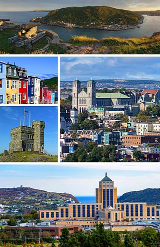
St. John's is the capital and largest city of the Canadian province of Newfoundland and Labrador. It is located on the eastern tip of the Avalon Peninsula on the island of Newfoundland. The city spans 446.04 km2 (172.22 sq mi) and is the easternmost city in North America.

<span class="mw-page-title-main">Corner Brook</span> City in Newfoundland and Labrador, Canada

Corner Brook is a city located on the west coast of the island of Newfoundland in the province of Newfoundland and Labrador, Canada. Corner Brook is the fifth largest settlement in Newfoundland and Labrador.

<span class="mw-page-title-main">Nain, Newfoundland and Labrador</span> Inuit community in Newfoundland and Labrador, Canada

Nain is the northernmost permanent settlement in the Canadian province of Newfoundland and Labrador, within the Nunatsiavut region, located about 370 km (230 mi) by air from Happy Valley-Goose Bay. The town was established as a Moravian mission in 1771 by Jens Haven and other missionaries. As of 2021, the population is 1,204 mostly Inuit and mixed Inuit-European. Nain is the administrative capital of the autonomous region of Nunatsiavut.

<span class="mw-page-title-main">Lawn, Newfoundland and Labrador</span> Town in Newfoundland and Labrador, Canada

Lawn,, is a town located at the tip of the Burin Peninsula on Newfoundland's South coast, Newfoundland and Labrador. Lawn is spread around a small harbour in a relatively lush valley. According to one local tradition it was this lushness that inspired Captain James Cook to name the place Lawn Harbour. But it has also been speculated that a Frenchman named the community after a doe caribou that he spotted there.

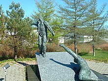
The 1929 Grand Banks earthquake occurred on November 18, 1929. The shock had a moment magnitude of 7.2 and a maximum Rossi–Forel intensity of VI and was centered in the Atlantic Ocean off the south coast of Newfoundland in the Laurentian Slope Seismic Zone.

<span class="mw-page-title-main">Marystown</span> Town in Newfoundland and Labrador, Canada

Marystown is a town in the province of Newfoundland and Labrador, Canada, with a population of around 5,000. Situated 306 km from the province's capital, St. John's, it is on the Burin Peninsula. Until the early 1990s, its economy was largely based on shipbuilding, and it is due in part to this that the town experienced a population increase of 295% in just over a decade. The town was also dependent on the fish plant for employment.

<span class="mw-page-title-main">Grand Bank (electoral district)</span> Provincial electoral district in Newfoundland and Labrador, Canada

Grand Bank is a defunct provincial electoral district for the House of Assembly of Newfoundland and Labrador, Canada. Prior to the 1974 redistribution, the district was called Burin. The district was abolished in 2015 and replaced by Burin-Grand Bank.

<span class="mw-page-title-main">Happy Valley-Goose Bay</span> Town in Newfoundland and Labrador, Canada

Happy Valley-Goose Bay is a town in the province of Newfoundland and Labrador, Canada.

The Burin Peninsula is a peninsula located on the south coast of the island of Newfoundland in the province of Newfoundland and Labrador. Marystown is the largest population centre on the peninsula.

<span class="mw-page-title-main">Burin, Newfoundland and Labrador</span> Town in Newfoundland and Labrador, Canada

Burin is a town on the Burin Peninsula in Placentia Bay, Newfoundland and Labrador, Canada. The Burin Peninsula is often affectionately nicknamed "The Boot" due to its resemblance to the footwear when seen on a map, with the town of Burin located near the "heel". Burin is approximately 318 km from the capital of St. John's. Settlement in Burin dates to the early 18th century, although documentary evidence indicates that French fishermen had been fishing and exploring the area even earlier.

<span class="mw-page-title-main">Geography of Newfoundland and Labrador</span> Lands of Canadas eastern-most province

Newfoundland and Labrador is the easternmost province in Canada. The Strait of Belle Isle separates the province into two geographical regions, Labrador and the island of Newfoundland. The province also includes over seven thousand small islands.

<span class="mw-page-title-main">Wabana, Newfoundland and Labrador</span> Town in Newfoundland and Labrador, Canada

Wabana is a Canadian town and the largest, and only incorporated, community on Bell Island in the province of Newfoundland and Labrador.

<span class="mw-page-title-main">Frenchman's Cove, Newfoundland and Labrador</span> Town in Newfoundland and Labrador, Canada

Frenchman's Cove is a town on the west coast of Burin Peninsula, Newfoundland and Labrador, Canada. It had a population of 159 in the Canada 2021 Census, a drop from 172 in 2011. The town has been inhabited since before 1836, the earliest known documentation about it, when it appeared in the first Newfoundland Census. According to local folklore and tradition, the first settlers were named Cleuetts and were of French origin. The small-boat inshore fishery was the economic mainstay of the area until the late 1800s when did men went work on the schooners operating from Grand Bank. Residents also grew turnips, cabbages, and potatoes, as well as hay for their horses, cattle, sheep, and chickens.

Lord's Cove is a town in the Canadian province of Newfoundland and Labrador. The town had a population of 155 in the Canada 2021 Census. Lord's Cove has a rich inshore fishing history and heritage. The town is approximately 65 km southeast of Marystown.

<span class="mw-page-title-main">Grey River, Newfoundland and Labrador</span> Local service district / designated place in Newfoundland and Labrador, Canada

Grey River is a local service district and designated place in the Canadian province of Newfoundland and Labrador. Grey River was first settled in the early 1800s by English 'youngsters' brought to Newfoundland via great merchant houses based at Ramea, Burgeo, and Gaultois. James Style(s) was the earliest known resident reported in 1835.

The St. Lawrence Laurentians is a soccer club founded in 1904 and based in St. Lawrence, Newfoundland.

<span class="mw-page-title-main">South East Bight</span> Local service district / designated place in Newfoundland and Labrador, Canada

South East Bight (SEB) or Southeast Bight is a local service district and designated place in the Canadian province of Newfoundland and Labrador. It is on the western shore of Placentia Bay on the Burin Peninsula. The community is not connected by road and is only accessible by ferry from Petite Forte. Many people from the community travel to Monkstown in the winter by snowmobile, but is very uncommon to try to get there in the summer, because of marsh, bogs, ponds and hills. To get to South East Bight one must travel towards Marystown on the Burin Peninsula, turn off the highway at Boat Harbour, travel to Petite Forte and then take a half-hour ferry ride to South East Bight.

Division No. 2, Newfoundland and Labrador is a census division in the Canadian province of Newfoundland and Labrador, primarily comprising the Burin Peninsula. Like all census divisions in Newfoundland and Labrador, but unlike the census divisions of some other provinces, the division exists only as a statistical division for census data, and is not a political entity.

<span class="mw-page-title-main">Outline of Newfoundland and Labrador</span> Overview of and topical guide to Newfoundland and Labrador

The following outline is provided as an overview of and topical guide to Newfoundland and Labrador.

References

  1. 1 2 Government of Canada, Statistics Canada (February 8, 2017). "Census Profile, 2016 Census - St. Lawrence, Town [Census subdivision], Newfoundland and Labrador and Division No. 2, Census division [Census division], Newfoundland and Labrador". www12.statcan.gc.ca.
  2. 1 2 "Canadian Climate Normals 1971-2000 Station Data". Environment and Climate Change Canada. 19 January 2011. Retrieved 17 August 2019.
  3. 1 2 "Population and dwelling counts: Canada, provinces and territories, census divisions and census subdivisions (municipalities), Newfoundland and Labrador". Statistics Canada. February 9, 2022. Retrieved March 15, 2022.
  4. Richard Clarke's Account of the Casting Away of the Delight (1584) in David B.Quinn Ed The Voyages and Colonising Enterprises of Sir Humphrey Gilbert, Vol.1, London:Hakluyt Society, 1940 p423-26.
  5. Prowse, Daniel Woodley (1896). A history of Newfoundland from the English, colonial, and foreign records. London: Eyre & Spottiswoode. p. 183. OL   7112345M.
  6. "In the Parliamentary Report of 1718 it is stated that nearly all the Poole vessels engaged in the Newfoundland trade were built in the Colony. Spurriers built barques, brigs, and ships at Oderin, Burin, and St. Lawrence". D.H. Prowse. p165.
  7. K. Matthews, Robert Newman, in Dictionary of Canadian Biography, vol. 5, University of Toronto/Université Laval, 2003–, accessed January 25, 2017
  8. 1 2 Holly McKenzie-Sutter (August 22, 2019). "Linden MacIntyre shares personal connection to Newfoundland disaster in The Wake". The Canadian Press.
  9. 1 2 3 "A disastrous tsunami's lethal legacy in Newfoundland - Macleans.ca". www.macleans.ca.
  10. "Standing Into Danger" by Cassie Brown
  11. "Chapter 1: The Story – Dead Reckoning: The Pollux-Truxtun Disaster". www.mun.ca.
  12. Echoes of Valour
  13. 1 2 The St. Lawrence Fluorspar Mines: A Brief History
  14. "St. Lawrence fluorspar mine gets $5M from feds, hundreds of jobs touted". CBC News. March 15, 2017.
  15. First fluorspar from St. Lawrence mine to ship this week: Haley
  16. CFI seeking new location for shipping port in St. Lawrence, NL
  17. Risdon, James. "Rocking it | Natural Resources Magazine".
  18. "St. Lawrence (Canada) - Wind farms - Online access - The Wind Power". www.thewindpower.net.
  19. Industrial park for St. Lawrence NL on hold
  20. "With 260 jobs at risk, receiver appointed to stave off Canada Fluorspar bankruptcy". CBC News . 2022-02-22. Archived from the original on 2022-03-18.
  21. "March 15".
  22. "Judge approves St. Lawrence mine sale process, with province committing up to $3.25M". CBC News . 2022-03-11. Archived from the original on 2022-09-04.
  23. "St. Lawrence Laurentian's Soccer".
  24. "HistoricPlaces.ca - HistoricPlaces.ca". www.historicplaces.ca.