
Annapolis County is a county in the Canadian province of Nova Scotia located in the western part of the province on the Bay of Fundy. The county seat is Annapolis Royal.
Division No. 1, Subdivision A is an unorganized subdivision on the Avalon Peninsula in Newfoundland and Labrador, Canada. It is in Division No. 1, and lies between Trinity Bay and Placentia Bay.

Division 1, Newfoundland and Labrador is a census division covering the entire Avalon Peninsula including the Isthmus of Avalon of the Canadian province of Newfoundland and Labrador. Like all census divisions in Newfoundland and Labrador, but unlike the census divisions of some other provinces, the division exists only as a statistical division for census data, and is not a political entity.
Division No. 8 is a census division on the north coast of the island of Newfoundland in the province of Newfoundland and Labrador, Canada. It has a land area of 9,315.44 km² and had a population of 37,121 at the 2011 census. Its largest communities are the towns of Lewisporte, Springdale, and Twillingate.

Telegraph Cove is a community of about 20 inhabitants, on Vancouver Island in British Columbia, Canada, located approximately 210 kilometres (130 mi) northwest of Campbell River. It is a former fishing and cannery village that has become a launch point for eco-tourism. It shares the inlet with Beaver Cove which is 3 km (2 mi) up the inlet.
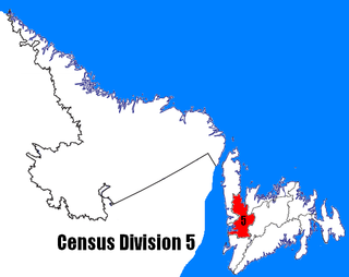
Census Division No. 5 is a Statistics Canada statistical division composed of the areas of the province of Newfoundland and Labrador called Humber Valley, Bay of Islands, and White Bay. It covers a land area of 10,365.63 km², and had a population of 41,004 at the 2011 census.
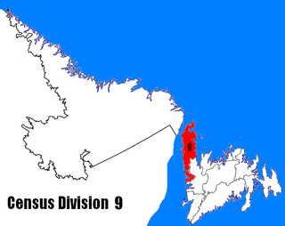
Census Division No. 9 is composed of the area of the province of Newfoundland and Labrador called the Northern Peninsula. It has a land area of 13,526.85 km² and had a population of 16,786 at the 2011 census. The largest community is the town of St. Anthony, near its northern tip, on the Atlantic Ocean coast.
Census Division No. 4 is a Statistics Canada statistical division that comprises the areas of the province of Newfoundland and Labrador called St. George's. It covers a land area of 7087.70 km² and had a population of 20,840 at the 2011 census.

North Arm Cove is a suburb of the Mid-Coast Council local government area in the Hunter and Mid North Coast regions of New South Wales, Australia, located adjacent to Port Stephens and extending well north of the Pacific Highway. The suburb is sparsely populated with most of the population living in the southern portion of the suburb.

The Cape Shore is a region on the southwestern portion of the Avalon Peninsula on the island of Newfoundland, Canada.
Division No. 2, Newfoundland and Labrador is a census division in the Canadian province of Newfoundland and Labrador, primarily comprising the Burin Peninsula. Like all census divisions in Newfoundland and Labrador, but unlike the census divisions of some other provinces, the division exists only as a statistical division for census data, and is not a political entity.
Division No. 3, Newfoundland and Labrador is a census division in the Canadian province of Newfoundland and Labrador, primarily comprising the South Coast of the island of Newfoundland. Like all census divisions in Newfoundland and Labrador, but unlike the census divisions of some other provinces, the division exists only as a statistical division for census data, and is not a political entity.
Division No. 7, Newfoundland and Labrador is a census division in the Canadian province of Newfoundland and Labrador, primarily comprising the Bonavista Bay region. Like all census divisions in Newfoundland and Labrador, but unlike the census divisions of some other provinces, the division exists only as a statistical division for census data, and is not a political entity.
Division No. 1, Subdivision C is an unorganized subdivision on the Avalon Peninsula in Newfoundland and Labrador, Canada. It is in Division 1 and contains the unincorporated communities of Cape St. Mary's, Cuslett, Gooseberry Cove, Great Barasway, Lears Cove, Patrick's Cove-Angels Cove, Ship Cove and Stoney House.

Division No. 1, Subdivision E is an unorganized subdivision on the Avalon Peninsula in Newfoundland and Labrador, Canada. It is in Division 1 and contains the unincorporated communities of Broad Cove, Dildo, Green's Harbour, Harnum Point, Hopeall, New Harbour and Reids Room.
Division No. 1, Subdivision F is an unorganized subdivision on the Avalon Peninsula in Newfoundland and Labrador, Canada. It is in Division 1 and contains the unincorporated communities of New Chelsea-New Melbourne-Brownsdale-Sibley's Cove-Lead Cove, Turks Cove
Division No. 1, Subdivision H is an unorganized subdivision on the Avalon Peninsula in Newfoundland and Labrador, Canada. It is in Division 1 and contains the unincorporated communities of Clowns Cove, Flatrock, Freshwater, Halfway House, Perry's Cove and Spout Cove.
Division No. 1, Subdivision I is an unorganized subdivision on the Avalon Peninsula in Newfoundland and Labrador, Canada. It is in Division 1 and contains the unincorporated community of Bristol's Hope.
Division No. 1, Subdivision L is an unorganized subdivision on the Avalon Peninsula in Newfoundland and Labrador, Canada. It is in Division 1 and contains the unincorporated communities of Bareneed, Black Duck Pond, Blow Me Down, Coley's Point South, Hibb's Cove, Pick Eyes, Port de Grave, Ship Cove and The Dock
Division No. 1, Subdivision U is an unorganized subdivision on the Avalon Peninsula in Newfoundland and Labrador, Canada, in Division 1. It contains the unincorporated communities of Admiral's Cove, Bauline East, Bauline South, Burnt Cove, Devils Kitchen, Flat Rock, St. Michaels and Seal Cove.


