Cape Bonavista Light

Last updated
Cape Bonavista
Cape Bonavista Lighthouse - August 2012.JPG
Cape Bonavista Lighthouse
Cape Bonavista Light
Location Bonavista Peninsula
Newfoundland
Newfoundland and Labrador
Canada
Coordinates 48°42′05.0″N53°05′07.1″W / 48.701389°N 53.085306°W / 48.701389; -53.085306
Tower
Constructed1843 (first)
Constructionlimestone tower (first)
steel skeletal tower (current)
Height11 metres (36 ft) (first)
12 metres (39 ft) (current)
Shapecylindrical tower with balcony and lantern on the roof of a two-story wooden keeper's house (first)
square pyramidal tower (current)
Markingstower and lantern with vertical red and white stripes (first)
OperatorBonavista Lighthouse Provincial Historic Site [1]
Heritageprovincial historic site  OOjs UI icon edit-ltr-progressive.svg
Fog signal blast every 30s.
Light
First lit1966 (current)
Deactivated1966 (first)
Focal height51 metres (167 ft) (current)
Characteristic Fl W 10s.

Cape Bonavista Light is a lighthouse located on Cape Bonavista, Newfoundland. The lighthouse, which operated from 1843 until 1962, is now a provincial museum, containing an exhibition about life in a lighthouse during the 1870s. [2]

Contents

History

Bonavista lighthouse with inuksuk in front, 2013 Bonavista lighthouse with inuksuk in front.jpg
Bonavista lighthouse with inuksuk in front, 2013

The lighthouse at Cape Bonavista was built between 1841 and 1843 to mark the entrances to Bonavista and Trinity bays and to aid mariners headed for Labrador. It is the fourth-oldest lighthouse in Newfoundland. The two-story wooden building is constructed around a masonry tower surmounted by a lantern.

The first lamps and reflectors came from the Bell Rock Lighthouse in Scotland. [3] This apparatus was later replaced by a catoptric system from the Isle of May in Scotland, first installed in Newfoundland in 1850 by Robert Oke at the Cape Pine lighthouse, later moved to the Harbour Grace Island lighthouse, and finally to Cape Bonavista. Both the historic light mechanisms that ended up at Cape Bonavista, the one from the Bell Rock and the one from Isle of May were installed by Robert Oke, who served as the first Chief Inspector of the Newfoundland Lighthouse Service. In 1962 the lighthouse went dark, replaced by an electric light on a nearby steel skeleton tower.

In the 1970s the lighthouse was restored for use as a museum by the provincial government. [4] The building contains furniture and artifacts representing the pre-1870 period. The rare catoptrics lighting system, made up of Argand oil lamps and parabolic mirrors of polished silver, is on display. Exhibits on local industry include coopering, fishing, whaling and sealing, as well as the ecological history of Cape Bonavista.

On August 3, 2001, a disastrous electrical storm struck Cape Bonavista. As lightning struck repeatedly all around the cape, the lighthouse tower was hit three times, igniting a fire. Quick action by the fire department prevented more severe damage. [5]

See also

Related Research Articles

<span class="mw-page-title-main">Bell Rock Lighthouse</span> Worlds oldest working sea-washed lighthouse, off the coast of Angus, Scotland

The Bell Rock Lighthouse, off the coast of Angus, Scotland, is the world's oldest surviving sea-washed lighthouse. It was built between 1807 and 1810 by Robert Stevenson on the Bell Rock in the North Sea, 11 miles (18 km) east of the Firth of Tay. Standing 35 metres (115 ft) tall, its light is visible from 35 statute miles (56 km) inland.

<span class="mw-page-title-main">Bonavista, Newfoundland and Labrador</span> Town in Newfoundland and Labrador, Canada

Bonavista is a town on the Bonavista Peninsula, Newfoundland in the Canadian province of Newfoundland and Labrador. Unlike many Newfoundland coastal settlements, Bonavista was built on an open plain, not in a steep cove, and thus had room to expand to its current area of 31.5 km2 (12.2 sq mi). Bonavista is located approximately 300 km by road from the provincial capital of St. John's.

<span class="mw-page-title-main">Cape Spear</span> Cape in Newfoundland and Labrador, Canada

Cape Spear is a headland located on the Avalon Peninsula of Newfoundland near St. John's in the Canadian province of Newfoundland and Labrador. At a longitude of 52°37' W, it is the easternmost point in Canada and North America, excluding Greenland.

<span class="mw-page-title-main">Bishop Rock</span> Skerry in the Atlantic Ocean off the coast of Cornwall, England

The Bishop Rock is a skerry off the British coast in the northern Atlantic Ocean known for its lighthouse. It is in the westernmost part of the Isles of Scilly, an archipelago 45 kilometres off the southwestern tip of the Cornish peninsula of Great Britain. The Guinness Book of Records lists it as the world's smallest island with a building on it.

<span class="mw-page-title-main">Bell Island (Newfoundland and Labrador)</span> Canadian island in Conception Bay

Bell Island is an island that is part of Newfoundland and Labrador, Canada's easternmost province. With an area of 34 square kilometres (13 sq mi), it is by far the largest island in Conception Bay, a large bay in the southeast of the island of Newfoundland. The provincial capital of St. John's is less than 20 kilometres (12 mi) to the east.

<span class="mw-page-title-main">Harbour Grace</span> Town in Newfoundland and Labrador, Canada

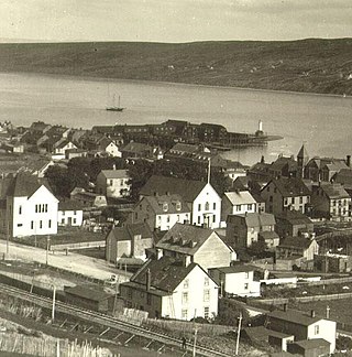
Harbour Grace is a town in Conception Bay on the Avalon Peninsula in the province of Newfoundland and Labrador, Canada. With roots dating back to the 16th century, it is one of the oldest towns in North America.

<span class="mw-page-title-main">St Anthony's Lighthouse</span> Lighthouse

St Anthony's Lighthouse is the lighthouse at St Anthony Head, on the eastern side of the entrance to Falmouth harbour, Cornwall, UK. The harbour is also known as Carrick Roads and is one of the largest natural harbours in the world.

Cape Bauld is a headland located at the northernmost point of Quirpon Island, an island just northeast of the Great Northern Peninsula of Newfoundland in the Canadian province of Newfoundland and Labrador.

<span class="mw-page-title-main">East Coast Trail</span>

The East Coast Trail (ECT) is a long-distance coastal footpath located in the Canadian province of Newfoundland and Labrador. It is a developed trail over 336 kilometres (209 mi) long, creation of which began in 1994. It is made up of 25 linked wilderness paths and passes through more than 30 communities. It was named one of the best adventure destinations by National Geographic in 2012 and is extended and improved yearly.

Cape Bonavista is a headland located on the east coast of the island of Newfoundland in the Canadian province of Newfoundland and Labrador. It is located at the northeastern tip of the Bonavista Peninsula, which separates Trinity Bay to the south from Bonavista Bay to the north. The nearby town of Bonavista takes its name from this historic landmark.

<span class="mw-page-title-main">Warrior Rock Light</span> Lighthouse

Warrior Rock Light is a lighthouse on Sauvie Island in the U.S. state of Oregon, which helps guide river traffic on the Columbia River around the Portland, Oregon area. It once contained the Pacific Northwest's oldest fog bell. It is Oregon's smallest lighthouse, and the only lighthouse, or one of only two lighthouses, still operating in Oregon which are not on the Pacific Ocean, depending on whether the Umpqua River Lighthouse is considered to be on the coast or on the Umpqua River.

The history of lighthouses in Canada dates to 1734.

<span class="mw-page-title-main">Newfoundland (island)</span> Island portion of Newfoundland and Labrador, Canada

Newfoundland is a large island within the Canadian province of Newfoundland and Labrador. It is situated off the eastern coast of the North American mainland and the geographical region of Labrador.

<span class="mw-page-title-main">Eilean Glas Lighthouse</span> Lighthouse

Eilean Glas Lighthouse is situated on the east coast of the island of Scalpay in the Outer Hebrides of Scotland. It was one of the original four lights commissioned by the Commissioners of the Northern Lights, and the first in the Hebrides. These lighthouses were built by Thomas Smith.

<span class="mw-page-title-main">Cape Race Lighthouse</span> Lighthouse on Newfoundland, Canada

Cape Race Lighthouse is an active lighthouse located at Cape Race on the Avalon Peninsula, Newfoundland. The light's characteristic is a single white flash every 7.5 seconds; additionally, a foghorn may sound a signal of two blasts every 60 seconds. It is located on one of Canada's busiest shipping lanes. The lighthouse is also a tourist attraction.
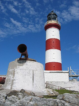
<span class="mw-page-title-main">Point Amour Lighthouse</span> Lighthouse

The Point Amour Lighthouse is a lighthouse located on Point Amour in southern Labrador, Canada. It is not far from L'Anse Amour, and was completed in 1857. It is the tallest lighthouse in Atlantic Canada, and the second tallest one in all of Canada, reaching a height of 109 feet (33m).

Oke is both a surname and a given name. Notable people with the name include:

Robert Oke, H.M. was the first chief inspector for the Newfoundland Lighthouse Service and served from at least 1848 to 1870. Oke installed the first light mechanism at the Cape Bonavista Light in 1842, and installed the famous Isle of May light mechanism at the Cape Pine Light in 1850, which was later moved to Harbour Grace Island and finally to Cape Bonavista, where it can be viewed today.

References

  1. Rowlett, Russ. "Lighthouses of Canada: Southeastern Newfoundland". The Lighthouse Directory. University of North Carolina at Chapel Hill . Retrieved December 29, 2015.
  2. Provincial Historic Site - A Guiding Light.
  3. "Cape Bonavista lighthouse". Lighthouse Depot. Archived from the original on 2005-08-31. Retrieved 2008-01-25.
  4. "Provincial Historic Sites of Newfoundland and Labrador". Archived from the original on 2006-05-20. Retrieved 2008-01-25.
  5. "Canada's Cape Bonavista Lighthouse Recovers from Disaster". Lighthouse Depot/Lighthouse Digest. Archived from the original on 2011-06-14. Retrieved 2010-10-02.