
Machias Seal Island is an island in disputed water between the Gulf of Maine and the Bay of Fundy, about 16 km (10 mi) southeast from Cutler, Maine, and 19 km (12 mi) southwest of Grand Manan Island, New Brunswick. Sovereignty of the island is disputed by the United States and Canada. The Canadian Coast Guard continues to staff a lighthouse on the island; the first lighthouse was constructed there in 1832.

Cape Ray is a headland located at the southwestern extremity of the island of Newfoundland in the Canadian province of Newfoundland and Labrador.
Cape Norman is a barren, limestone headland located at the northernmost point of insular Newfoundland in the Canadian province of Newfoundland and Labrador.
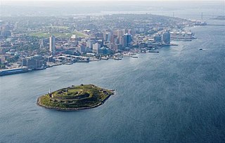
Georges Island is a glacial drumlin and the largest island entirely within the harbour limits of Halifax Harbour located in Nova Scotia's Halifax Regional Municipality. The Island is the location of Fort Charlotte - named after King George's wife Charlotte. Fort Charlotte was built during Father Le Loutre's War, a year after Citadel Hill. The island is now a National Historic Site of Canada. As of August 6, 2020, the island is open to public tours through Thanksgiving weekend.

McNabs Island is the largest island in Halifax Harbour located in Halifax Regional Municipality, Nova Scotia, Canada. It played a major role in defending Halifax Harbour and is now a provincial park. The island was settled by Britons in the 1750s and later by Peter McNab, and McNab family members lived on the island until 1934.

Seal Island is an island on the outermost extreme of Southwestern Nova Scotia, Canada, in the Municipality of the District of Argyle in Yarmouth County. It is approximately 4.3 kilometres (2.7 mi) long and 0.8 kilometres (0.50 mi) wide and is surrounded on its east, south and west sides by dangerous shoals. It is surrounded by the Atlantic Ocean and is the biggest of a group of five islands which extend north for 12 kilometres (7.5 mi). It is the second southernmost point of land of Nova Scotia. The southern tip of nearby Cape Sable Island is 250 metres (820 ft) farther south than the southern tip of land on Seal Island.

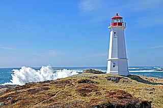
Sambro Island Lighthouse is a landfall lighthouse located at the entrance to Halifax Harbour, Nova Scotia, on an island near the community of Sambro in the Halifax Regional Municipality. It is the oldest surviving lighthouse in North America and its construction is a National Historic Event.

Burnt Islands is a small coastal community found in God Bay on the southwest coast of Newfoundland, Canada.
Louisbourg Lighthouse is an active Canadian lighthouse in Louisbourg, Nova Scotia. The current tower is the fourth in a series of lighthouses that have been built on the site, the earliest was the first lighthouse in Canada.
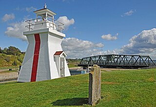
The Miminegash Range Lights were a set of range lights on Prince Edward Island, Canada. They were built in 1886, and deactivated in 1972; only the rear tower has survived.

The Warren Cove Range Lights are a set of range lights on Rocky Point, Prince Edward Island, Canada. They were built in 1907, and are still active.

Low Point Lighthouse is an historic Canadian lighthouse marking the eastern entrance to Sydney Harbour at New Victoria, Nova Scotia, near New Waterford, Nova Scotia. This is one of the earliest and most important light stations of Nova Scotia, one of the first dozen beacons in Nova Scotia to be lit to guide mariners, a classic red-and-white lighthouse still operated by the Canadian Coast Guard.

The Devils Island Light is a Nova Scotia lighthouse located at the eastern shore entrance to Halifax Harbour on Devils Island, Nova Scotia. First lit in 1852, it was succeeded by a second lighthouse in 1877 which survives today. The lighthouse has influenced regional folklore and remains an important community landmark although it is currently neglected and threatened.

Peggys Point Lighthouse, also known as Peggys Cove Lighthouse, is an active lighthouse and an iconic Canadian image. Located within Peggy's Cove, Nova Scotia, it is one of the busiest tourist attractions in the province and is a prime attraction on the Lighthouse Trail scenic drive. The lighthouse marks the eastern entrance of St. Margarets Bay and is officially known as the Peggys Point Lighthouse.

Caribou Island Lighthouse sits on the uninhabited Caribou Island in the eastern end of Lake Superior, 22 miles (35 km) south of Michipicoten Island. It lies entirely within the territorial waters of Canada although only about three miles from the international border between Canada and the United States. It is approximately 3 miles (4.8 km) long and approximately 1 mile (1.6 km) wide.
Balache Point Lighthouse also known as Balache Point Range Rear Lighthouse is an active Canadian lighthouse located next to the Canso Canal, near Port Hastings, Inverness County, Nova Scotia. The salt shaker style light, which sits on a small hillock on the Cape Breton side of the canal, is the second lighthouse to be built on the site.
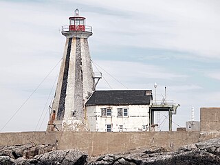
The Gannet Rock Lighthouse is a Canadian lighthouse located on a rocky islet 8 miles (13 km) south of Grand Manan in the Bay of Fundy. It was first lit in 1831 and was staffed until 1996. It was solarized in 2002 and remains operational in 2017. It was declared "surplus to requirements" by the Canadian Coast Guard in 2010 and is no longer being maintained.

Grandique Point Lighthouse is an aid to navigation for Lennox Passage, which is the channel of water between the southern shore of Cape Breton Island and Isle Madame, Nova Scotia, Canada. The lighthouse is located on the beach at Grandique Point in Lennox Passage Provincial Park and is accessible by a gravel road within the provincial park. The site is open to the public, the tower is closed.


