
Cape Breton Island is a rugged and irregularly shaped island on the Atlantic coast of North America and part of the province of Nova Scotia, Canada.

The Gulf of St. Lawrence fringes the shores of the provinces of Quebec, New Brunswick, Nova Scotia, Prince Edward Island, Newfoundland and Labrador, in Canada, plus the islands Saint-Pierre and Miquelon, possessions of France, in North America.'
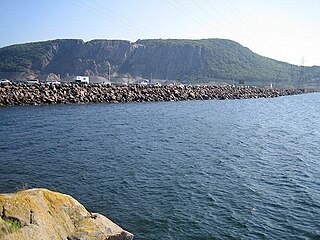
The Canso Causeway is a 1,385 m (4,544 ft) rock-fill causeway crossing the Strait of Canso, connecting Cape Breton Island by road to the Nova Scotia peninsula. Its crest thickness is 40 m (130 ft), carrying the two vehicle traffic lanes of the Trans-Canada Highway, Nova Scotia Highway 104 on the mainland side, and Nova Scotia Highway 105 on the Cape Breton side, as well as the single track mainline of the Cape Breton and Central Nova Scotia Railway.

The Canso Canal is a short canal located in Nova Scotia, Canada.
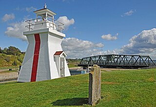
A Pepperpot or Salt Shaker lighthouse is a type of small lighthouse that has an architectural style similar to a scaled up salt or pepper shaker. These lighthouses feature a square tapered base with a single gallery and a square lantern. They are usually shingled in wood and painted white; the lantern and trim are red. Many such lighthouses still exist across Canada, especially in the Maritime provinces.

Point Aconi is a rural community in Nova Scotia at the northeastern tip of Boularderie Island. It derives its name from the headland of the same name, Point Aconi.
Port Hastings is an unincorporated settlement on Cape Breton Island, within the Municipality of the County of Inverness, Canada. The population in 2021 was 90.

The Canso Canal Bridge is a rotating swing bridge in Nova Scotia, Canada. It crosses the Canso Canal at the eastern end of the Canso Causeway, connecting the Nova Scotia peninsula to Cape Breton Island. The bridge carries the 2 traffic lanes of Highway 104 as well as a single track railway line operated by the Cape Breton and Central Nova Scotia Railway (CBNS).
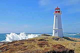
Louisbourg Lighthouse is an active Canadian lighthouse in Louisbourg, Nova Scotia. The current tower is the fourth in a series of lighthouses that have been built on the site, the earliest was the first lighthouse in Canada.

The Wood Islands Lighthouse is a historic lighthouse built by Donald MacMillan situated on the southeastern shore of Prince Edward Island, located in the community of Wood Islands. The lighthouse is a well-preserved three storey tower with an adjoining 1+1⁄2-storey keeper's residence. The white shingled tower is topped by a red iron lantern, which is enclosed by a white railing on the observation deck. The red roof of the dwelling provides a striking contrast to the white shingled exterior of the dwelling.

The Cascumpeque Light is a deactivated lighthouse on the western north coast of Prince Edward Island, Canada. The station was established in 1856 and the lighthouse itself was built in 1899.
The history of lighthouses in Canada dates to 1734.

The Barra Strait is a 1.22 km (0.76 mi) wide channel located in the Canadian province of Nova Scotia. It connects the northern and southern basins of Bras d'Or Lake, an inland saltwater body that dominates the centre of Cape Breton Island. The border between two of Cape Breton Island's counties runs through the strait; the community of Grand Narrows, in Cape Breton County, is situated on the eastern shore while the community of Iona, in Victoria County is situated on the western shore.

Low Point Lighthouse is an historic Canadian lighthouse marking the eastern entrance to Sydney Harbour at New Victoria, Nova Scotia, near New Waterford, Nova Scotia. This is one of the earliest and most important light stations of Nova Scotia, one of the first dozen beacons in Nova Scotia to be lit to guide mariners, a classic red-and-white lighthouse still operated by the Canadian Coast Guard.

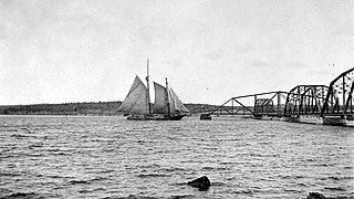
The Grand Narrows Bridge is a Canadian railway bridge crossing between Victoria County, Nova Scotia, and Cape Breton County. At 516.33 m (1,694 ft), it is the longest railroad bridge in the province. The bridge incorporates a swing span at its eastern end to permit the continued passage of marine traffic through the strait.

The Devils Island Light is a Nova Scotia lighthouse located at the eastern shore entrance to Halifax Harbour on Devils Island, Nova Scotia. First lit in 1852, it was succeeded by a second lighthouse in 1877 which survives today. The lighthouse has influenced regional folklore and remains an important community landmark although it is currently neglected and threatened.
Lennox Passage is a navigable waterway between Cape Breton Island and Isle Madame in Nova Scotia, Canada. Small craft use the relatively protected Passage traveling to and from St. Peters Canal at the village of St. Peter's and the Strait of Canso to avoid sailing around the east coast of Cape Breton in the open Atlantic Ocean.

Lennox Passage Provincial Park is a small picnic and beach park on the shores of Lennox Passage on the North Shore of Isle Madame on Cape Breton Island, Nova Scotia, with 2 kilometres (1.2 mi) of shoreline, an operating lighthouse and site of a former post office, ferry terminal and two limestone quarries. Visitors can picnic at tables scattered through a forest and open areas, enjoy the 2 kilometres (1.2 mi) of trails, or explore the working lighthouse. In summer the park offers swimming, kayaking, and biking opportunities. There are snowshoeing and cross-country skiing opportunities in the winter, however parking is available at the gate only in the off-season.

Grandique Point Lighthouse is an aid to navigation for Lennox Passage, which is the channel of water between the southern shore of Cape Breton Island and Isle Madame, Nova Scotia, Canada. The lighthouse is located on the beach at Grandique Point in Lennox Passage Provincial Park and is accessible by a gravel road within the provincial park. The site is open to the public, the tower is closed.


