List of lighthouses in Canada

Last updated

Sheringham Point Lighthouse Sheringham Point Lighthouse.jpg
Sheringham Point Lighthouse

This is a list of lighthouses in Canada . These may naturally be divided into lighthouses on the Pacific coast, on the Arctic Ocean, in the Hudson Bay watershed, on the Labrador Sea and Gulf of St. Lawrence, in the St. Lawrence River watershed (including the Great Lakes), and on the Atlantic seaboard.

Contents

British Columbia

Fisgard Light Fisgard Lighthouse - Colwood BC.jpg
Fisgard Light

Sources: [2] [3]

Manitoba

Newfoundland and Labrador

Labrador

This is a list of lighthouses in Labrador . [4] [5]

NameImageYear
built
[4]
Location &
coordinates
Class of Light
[5]
Focal
height
[5]
NGA
number
[5]
Admiralty
number
[5]
Range
nml
[5]
Belle Isle Northeast Light Bull Head Lighthouse.jpg 1905 Belle Isle
52°00′50″N55°16′50″W / 52.013944°N 55.280611°W / 52.013944; -55.280611
Fl W 10s.137 metres (449 ft)984H009617
Belle Isle South End Lower Light Image 1908 Belle Isle
51°52′42″N55°23′01″W / 51.878346°N 55.383561°W / 51.878346; -55.383561
Fl W 20s.50 metres (160 ft)992H010418
Belle Isle South End Upper Light Image 1858 Belle Isle
51°52′49″N55°22′55″W / 51.880293°N 55.382059°W / 51.880293; -55.382059
Fl W 20s.137 metres (449 ft)988H010218
Camp Island Lightn/a Division No. 10
52°10′11″N55°38′56″W / 52.169796°N 55.648834°W / 52.169796; -55.648834
Fl W 5s.42 metres (138 ft)976H009415
Castle Island Lightn/a Division No. 10
51°58′20″N55°51′11″W / 51.972214°N 55.853042°W / 51.972214; -55.853042
Fl W 6s.20 metres (66 ft)980H010815
Double Island Light Image 1905 Battle Harbour
52°15′20″N55°33′14″W / 52.255532°N 55.553845°W / 52.255532; -55.553845
Fl W 6s.38 metres (125 ft)968H00927
Kenamu River Range Front Lightn/a Hamilton Inlet
53°28′48″N59°53′51″W / 53.480079°N 59.897464°W / 53.480079; -59.897464
Oc G 6s.7 metres (23 ft)904H007713
Kenamu River Range Rear Lightn/a Hamilton Inlet
53°28′29″N59°55′02″W / 53.474703°N 59.917180°W / 53.474703; -59.917180
Oc G 6s.7 metres (23 ft)900H0076.513
Point Amour Lighthouse Point Amour Lighthouse.JPG 1858 Division No. 10
51°27′38″N56°51′30″W / 51.460616°N 56.858281°W / 51.460616; -56.858281
Oc W 20s.46 metres (151 ft)1012H011424
Red Bay Light Image 1906 est. Saddle Island
51°43′29″N56°26′10″W / 51.724709°N 56.436001°W / 51.724709; -56.436001
Fl W 5s.36 metres (118 ft)1000H011015
St Modeste Island Light Image 1956 West St. Modeste
51°35′42″N56°42′03″W / 51.595083°N 56.700899°W / 51.595083; -56.700899
inactive
since 2010
5.5 metres (18 ft)
tower height
1004H0111
Terrington Narrows Lightn/a Happy Valley-Goose Bay
53°20′38″N60°24′06″W / 53.343961°N 60.401736°W / 53.343961; -60.401736
Dir WRG10 metres (33 ft)910H0076.319

Newfoundland Atlantic Coast

This is a list of lighthouses on Newfoundland's Atlantic Coast. [6] [7] [5]

NameImageYear
built
Location &
coordinates
Class of Light
[5]
Focal
height
[5]
NGA
number
[5]
Admiralty
number
[5]
Range
nml
[5]
Bacalhao Island Light Image 1894 Bacalhao Island
49°41′13″N54°33′24″W / 49.686896°N 54.556774°W / 49.686896; -54.556774
Fl W 10s.106 metres (348 ft)1300H063617
Bacalhao Island Sector Light Image 2006 Bacalhao Island
49°41′13″N54°33′24″W / 49.686896°N 54.556774°W / 49.686896; -54.556774
Dir WRG71 metres (233 ft)1302H063523
Baccalieu Island North Point Light Image 1859 Baccalieu Island
48°09′00″N52°47′54″W / 48.149909°N 52.798229°W / 48.149909; -52.798229
Fl W 6s.176 metres (577 ft)1736H04987
Baccalieu Island Southwest Point Light Image 1953 Baccalieu Island
48°06′26″N52°48′39″W / 48.107307°N 52.810917°W / 48.107307; -52.810917
Fl W 10s.53 metres (174 ft)1740H050016
Bay Bulls Light Bull Head Lighthouse.jpg 1908 Bay Bulls
47°18′39″N52°44′49″W / 47.310878°N 52.747054°W / 47.310878; -52.747054
Fl W 6s.62.5 metres (205 ft)1872H04527
Bell Island Light Bell Island Lighthouse.jpg 1966 Bell Island
47°39′18″N52°54′59″W / 47.655030°N 52.916379°W / 47.655030; -52.916379
Fl W 6s.53 metres (174 ft)1836H047017
Brigus Light Image 1885 Brigus
47°32′54″N53°10′56″W / 47.548469°N 53.182095°W / 47.548469; -53.182095
Fl W 3s.34 metres (112 ft)1788H04788
Cabot Islands Light Image 1880 Bonavista Bay
49°10′30″N53°22′01″W / 49.175125°N 53.366840°W / 49.175125; -53.366840
Fl W 10s.23 metres (75 ft)1496H057617
Cape Bauld Light Image 1962 Quirpon Island
51°38′24″N55°25′38″W / 51.640074°N 55.427249°W / 51.640074; -55.427249
Fl W 15s.54 metres (177 ft)1052H013217
Cape Bonavista Light NLE Bonavista2 tango7174.jpg 1843 Bonavista Peninsula
48°42′05″N53°05′07″W / 48.701521°N 53.085230°W / 48.701521; -53.085230
Fl W 10s.51 metres (167 ft)1644H053616
Cape Norman Light Image Archived 2016-10-12 at the Wayback Machine 1964 Cape Norman
51°37′42″N55°54′21″W / 51.628254°N 55.905872°W / 51.628254; -55.905872
Fl (3) W 30s.35 metres (115 ft)1032H014021
Cape Race Lighthouse Cape race nfld.jpg 1907 Avalon Peninsula
46°39′31″N53°04′26″W / 46.658667°N 53.073778°W / 46.658667; -53.073778
Fl W 7.5s52 metres (171 ft)1904H044424
Cape Spear Light Cape Spear Lighthouse National Historic Site.jpg 1955 Cape Spear
47°31′12″N52°37′25″W / 47.520028°N 52.623611°W / 47.520028; -52.623611
Fl (3) W 15s.71 metres (233 ft)1868H045420
Cape St. Francis Light Image 1957 Cape St. Francis
47°48′32″N52°47′12″W / 47.808799°N 52.786696°W / 47.808799; -52.786696
Fl W 5s.29 metres (95 ft)1844H046815
Conche Light Image 1992 Conche
50°53′10″N55°53′51″W / 50.886167°N 55.897514°W / 50.886167; -55.897514
Fl R 6s.6 metres (20 ft)1096H07224
Ferryland Head Light Ferryland Lighthouse.jpg 1871 Ferryland
47°01′01″N52°51′27″W / 47.016900°N 52.857512°W / 47.016900; -52.857512
Fl W 10s.58 metres (190 ft)1876H045015
Fort Amherst Lighthouse Fort Amherst lighthouse, St. John's, NL.jpg 1951 St. John's
47°33′49″N52°40′50″W / 47.563524°N 52.680424°W / 47.563524; -52.680424
Fl W 15s.40 metres (130 ft)1848H045817
Fox Point Light Image Archived 2016-10-13 at the Wayback Machine 2003 Fox Point
51°21′22″N55°33′18″W / 51.356172°N 55.555109°W / 51.356172; -55.555109
Fl W 10s.27 metres (89 ft)1068H073017
Green Island Light Image 1857 Green Island (Catalina), Newfoundland
48°30′15″N53°02′36″W / 48.504133°N 53.043268°W / 48.504133; -53.043268
Fl W 4s.28 metres (92 ft)1648H052615
Green Point Light Image Archived 2016-10-11 at the Wayback Machine 1883 Green Point
47°36′41″N53°10′36″W / 47.611522°N 53.176714°W / 47.611522; -53.176714
L Fl W 10s.17 metres (56 ft)1784H04826
Gull Island Lighthouse Image 1884 Baie Verte Peninsula
49°59′51″N55°21′48″W / 49.997388°N 55.363336°W / 49.997388; -55.363336
Fl W 10s.160 metres (520 ft)1172H068617
Hant's Harbour Light Image Archived 2017-02-11 at the Wayback Machine 1957 Hant's Harbour
48°01′19″N53°15′16″W / 48.021832°N 53.254533°W / 48.021832; -53.254533
Iso W 6s.20 metres (66 ft)1728H050413
Heart's Content Light NL 2010-04-25 14-43-18 (4553040194).jpg 1901 Heart's Content
47°52′56″N53°23′07″W / 47.882348°N 53.385264°W / 47.882348; -53.385264
Oc W 6s.25 metres (82 ft)1716H05108
King's Cove Head Light Kings Cove Head Lighthouse.jpg 1893 King's Cove
48°34′33″N53°19′21″W / 48.575787°N 53.322554°W / 48.575787; -53.322554
Fl W 4s.54 metres (177 ft)1620H05405
Little Denier Island Lighthouse Image 1888 Bonavista Bay
48°41′09″N53°35′23″W / 48.685787°N 53.589702°W / 48.685787; -53.589702
Fl W 3s.91 metres (299 ft)1608H05437
Long Island East End Light Image 2009 Lushes Bight–Beaumont–Beaumont North
49°35′51″N55°34′50″W / 49.597612°N 55.580435°W / 49.597612; -55.580435
Fl W 6s.31 metres (102 ft)1212H06757
Long Point Lighthouse CrowHeadNL Light.JPG 1876 Twillingate
49°41′16″N54°48′00″W / 49.687746°N 54.800070°W / 49.687746; -54.800070
Fl W 5s.101 metres (331 ft)1272H064016
Offer Wadham Lighthouse Image 1990s Wadham Islands
49°35′37″N53°45′47″W / 49.593495°N 53.762956°W / 49.593495; -53.762956
Fl W 3s.30 metres (98 ft)1440H05846
Peckford Island Lighthouse Image 1961 Wadham Islands
49°31′50″N53°51′05″W / 49.530516°N 53.851437°W / 49.530516; -53.851437
Fl W 10s.16 metres (52 ft)1440H058617
Puffin Island Light Image 1956 Greenspond
49°03′42″N53°33′04″W / 49.061652°N 53.551048°W / 49.061652; -53.551048
Fl W 5s.21 metres (69 ft)1556H055616
Random Head Harbour Light Image 1895 Random Island
48°05′41″N53°32′43″W / 48.094731°N 53.545303°W / 48.094731; -53.545303
Fl W 3s.38 metres (125 ft)1704H05147
Surgeon Cove Point Light Image 1911 Notre Dame Bay
49°31′08″N55°07′02″W / 49.518825°N 55.117349°W / 49.518825; -55.117349
Fl W 5s.74 metres (243 ft)1240H065616
Westport Cove Light Image 1906 Westport
49°47′11″N56°38′45″W / 49.786348°N 56.645903°W / 49.786348; -56.645903
Fl W 4s.10 metres (33 ft)1140H07047

Newfoundland South Coast

This is a list of lighthouses in Newfoundland South Coast. [8] [9] [5]

NameImageYear
built
Location &
coordinates
Class of Light
[5]
Focal
height
[5]
NGA
number
[5]
Admiralty
number
[5]
Range
nml
[5]
Boar Island Light Image Archived 2016-10-23 at the Wayback Machine 1874 est. Burgeo
47°36′24″N57°35′12″W / 47.606622°N 57.586649°W / 47.606622; -57.586649
Fl W 5s.63 metres (207 ft)2394H026015
Cape Pine Light Cape Pine lighthouse.jpg 1851 Cape Pine
46°37′02″N53°31′54″W / 46.617142°N 53.531591°W / 46.617142; -53.531591
Fl W 5s.96 metres (315 ft)1920H044016
Cape Ray Light Cap Ray Lightstation 173.jpg 1959 Cape Ray
47°37′16″N59°18′14″W / 47.621139°N 59.303944°W / 47.621139; -59.303944
Fl W 15s.36 metres (118 ft)2492H022017
Cape St. Mary's Light CapeStMarysLight.jpg 1860 Cape St. Mary's
46°49′23″N54°11′46″W / 46.823065°N 54.196105°W / 46.823065; -54.196105
Fl W 5s.119 metres (390 ft)1952H043221
Channel Head Light Channel PortAuxBasques Light.JPG 1895 Channel-Port aux Basques
47°33′57″N59°07′25″W / 47.565876°N 59.123659°W / 47.565876; -59.123659
Fl W 10s.29 metres (95 ft)2468H022217
Colombier Islands Light Image 1971 est. Burnt Islands
47°35′31″N58°53′51″W / 47.591885°N 58.897382°W / 47.591885; -58.897382
Fl W 5s.18 metres (59 ft)2436H023815
Dawson Point Light Image Archived 2016-03-07 at the Wayback Machine 1916 est. Pushthrough
47°38′37″N47°38′37″W / 47.643491°N 47.643491°W / 47.643491; -47.643491
Fl W 5s.17 metres (56 ft)2352H027616
Garnish Light Image 1885 est. Garnish
47°14′11″N55°21′30″W / 47.236495°N 55.358310°W / 47.236495; -55.358310
Q R8 metres (26 ft)2264H03186
Grand Bank East Pier Light Image Archived 2016-10-12 at the Wayback Machine 1922 Grand Bank
47°06′05″N55°44′58″W / 47.101295°N 55.749384°W / 47.101295; -55.749384
Q G8 metres (26 ft)2248H03225
Green Island Light Image Archived 2016-10-13 at the Wayback Machine 1993
46°52′48″N56°05′08″W / 46.880090°N 56.085543°W / 46.880090; -56.085543
Fl W 10s.45 metres (148 ft)2156H034815
Little Burin Island Light Image 1915 est. Placentia Bay
46°58′50″N55°11′27″W / 46.980564°N 55.190916°W / 46.980564; -55.190916
Fl W 10s.26 metres (85 ft)2120H036417
Long Island South Point Light Image 2004
47°17′53″N54°42′16″W / 47.298112°N 54.704554°W / 47.298112; -54.704554
Fl W 5s.72 metres (236 ft)2068H03805
Northwest Head Light Image 1902 Ramea
47°30′45″N57°24′31″W / 47.512489°N 57.408663°W / 47.512489; -57.408663
Fl W 3s.38 metres (125 ft)2380H026413
Point Verde Light Image 1990 Point Verde
47°14′15″N54°00′55″W / 47.237558°N 54.015327°W / 47.237558; -54.015327
Fl W 5s.30 metres (98 ft)1960H042213
Powles Head Light Image Archived 2016-10-11 at the Wayback Machine 1960 Trepassey
46°41′25″N53°24′06″W / 46.690229°N 53.401609°W / 46.690229; -53.401609
Fl W 10s.31 metres (102 ft)1908H044222
Rose Blanche Light Rose Blanche Lighthouse - 2012.JPG 1996 Rose Blanche-Harbour le Cou
47°36′06″N58°41′41″W / 47.601676°N 58.694592°W / 47.601676; -58.694592
Fl R 10s.29 metres (95 ft)2418H0242.513
St. Jacques Island Light Image Archived 2016-10-29 at the Wayback Machine 1908 St. Jacques-Coomb's Cove
47°28′25″N55°24′22″W / 47.473746°N 55.406051°W / 47.473746; -55.406051
Fl W 6s.40 metres (130 ft)2292H030416

Newfoundland West Coast

This is a list of lighthouses in Newfoundland West Coast. [10] [11] [5]

NameImageYear
built
Location &
coordinates
Class of Light
[5]
Focal
height
[5]
NGA
number
[5]
Admiralty
number
[5]
Range
nml
[5]
Broad Cove Point Range Front Light Image 1955 Stephenville, Newfoundland and Labrador
48°41′19″N58°41′04″W / 48.688496°N 58.684545°W / 48.688496; -58.684545
inactive since 20059 metres (30 ft)
(tower)
ex-2584ex- H0199---
Broad Cove Point Range Rear Light Image 1955 Stephenville, Newfoundland and Labrador
48°41′10″N58°40′53″W / 48.686198°N 58.681498°W / 48.686198; -58.681498
inactive since 200515 metres (49 ft)
(tower)
ex-2588ex-H0199.1---
Cape Anguille Lighthouse Cape Anguille Lighthouse.jpg 1960 Cape Anguille
47°54′03″N59°24′40″W / 47.900703°N 59.411101°W / 47.900703; -59.411101
Fl W 5s.25 metres (82 ft)2504H021815
Cow Head Light CowHeadLight.JPG 1905 Cow Head
49°55′12″N57°49′32″W / 49.920076°N 57.825525°W / 49.920076; -57.825525
inactive since 19885 metres (16 ft)
(tower)
ARLHS
CAN-680
------
Flowers Cove Light Image 1899 Flowers Cove
51°18′30″N56°44′55″W / 51.308380°N 56.748497°W / 51.308380; -56.748497
Fl G 3s.5 metres (16 ft)2724H01444
Harbour Point Light Image Archived 2016-10-26 at the Wayback Machine 1883Harbour Point
48°27′26″N58°29′19″W / 48.457238°N 58.488707°W / 48.457238; -58.488707
Fl W 6s.11 metres (36 ft)2516H02085
Keppel Island Light Image 1992 Port Saunders
50°37′59″N57°19′20″W / 50.633116°N 57.322133°W / 50.633116; -57.322133
Fl W 15s.36 metres (118 ft)2668H015617
Lobster Cove Head Light Lobster Cove Lighthouse (7892591044).jpg 1897 Lobster Cove
49°36′10″N57°57′21″W / 49.602880°N 57.955876°W / 49.602880; -57.955876
Iso W 4s.35 metres (115 ft)2640H016412
New Férolle Peninsula Light Image 1913 Reefs Harbour-Shoal Cove West-New Ferolle
51°01′21″N57°05′44″W / 51.022574°N 57.095690°W / 51.022574; -57.095690
Q (4) W 7.5s.28 metres (92 ft)2704H014920
Point Riche Lighthouse Port aux Choix lighthouse.jpg 1892 Port au Choix
50°41′54″N57°24′38″W / 50.6984°N 57.4105°W / 50.6984; -57.4105
Fl W 5s.29 metres (95 ft)2680H015415
South Head Light Image 2010 Lark Harbour
49°08′48″N58°22′13″W / 49.146667°N 58.370361°W / 49.146667; -58.370361
Fl W 4s.35 metres (115 ft)2604H01926
Woody Point Light Woody Point Light.jpg 1959 Woody Point
49°30′17″N57°54′45″W / 49.504795°N 57.912532°W / 49.504795; -57.912532
Fl R 4s.14 metres (46 ft)2644H01684

New Brunswick

Sources: [12] [13] [14]

Nova Scotia

Sources: [15]

Ontario

The no longer operating Old Cut Lighthouse, located on Long Point. Lighthouse on Long Point, Norfolk County.jpg
The no longer operating Old Cut Lighthouse, located on Long Point.

Sources: [17] [18]

Prince Edward Island

Quebec

See also

Related Research Articles

<span class="mw-page-title-main">Cape Beale Light</span> Lighthouse

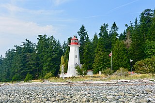
Cape Beale Lightstation is an active manned lighthouse on Vancouver Island in British Columbia., Canada.

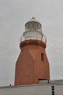
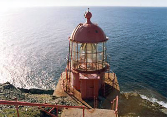
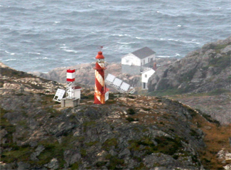
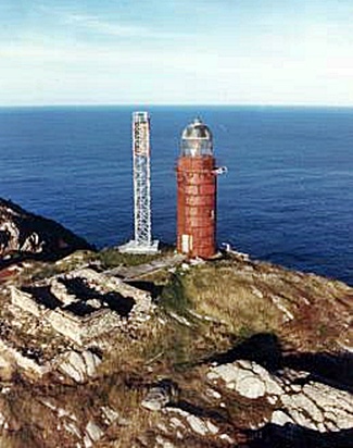
Belle Isle Northeast Light is a 27-metre (89 ft) tall, 12-sided flying buttress lighthouse located on Belle Isle, Newfoundland, which was built in 1905. It is one of three lighthouses on the island and was maintained by the Canadian Government despite the fact that Newfoundland did not join Confederation until 1949. It was designed by William P. Anderson as one in a series of nine buttressed lighthouses built in Canada around 1910.

The Langara Point Lighthouse is a staffed lighthouse located atop a scenic bluff on the northwest corner of Langara Island. It is one of only two lighthouses in Haida Gwaii – the other being at Cape St. James, at the southern tip of the islands. Both were built in 1913.

<span class="mw-page-title-main">Scotch Cap Light</span> Lighthouse in Alaska, United States

The Scotch Cap Light is a series of lighthouses located on the southwest corner of Unimak Island in Alaska. It was the first station established on the outside coast of Alaska.

<span class="mw-page-title-main">Cape Anguille</span>

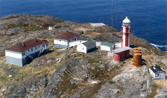
Cape Anguille is a headland and the westernmost point in Newfoundland, reaching into the Gulf of Saint Lawrence. It is the southern edge of St. George's Bay. Its name is derived from the French word anguille, which means eel. Close to the cape is the community of Cape Anguille.

<span class="mw-page-title-main">Long Point Lighthouse</span> Lighthouse

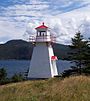
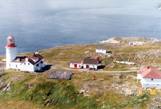
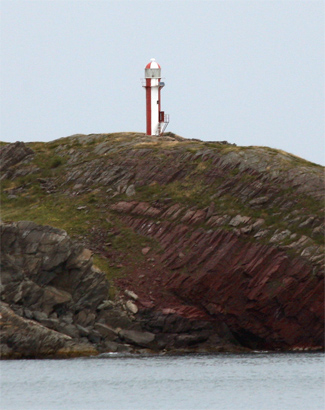
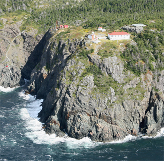
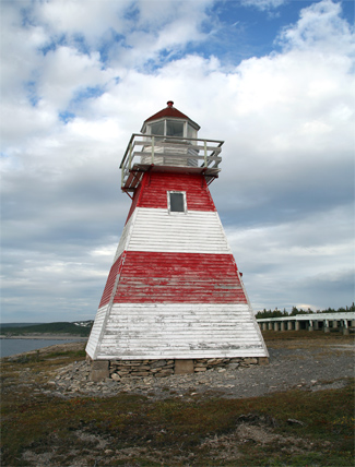
Long Point Lighthouse is an active Canadian lighthouse located outside Crow Head on North Twillingate Island off the northeast coast of Newfoundland. The lighthouse, completed in 1876, attracts thousands of tourists each year and is historic to the town of Twillingate.

<span class="mw-page-title-main">Gros Cap Reefs Light</span> Lighthouse

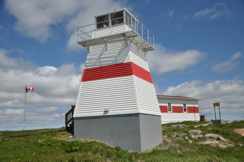
The Gros Cap Reefs Light is a lighthouse located at the entrance to St. Mary's River from Whitefish Bay of Lake Superior. The light was completed in 1953 and replaced a lightship stationed there since 1923. The lighthouse, owned by the Canadian Coast Guard, is located on the southwest edge of the Gros Cap Reef.

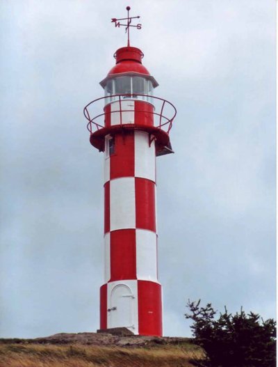
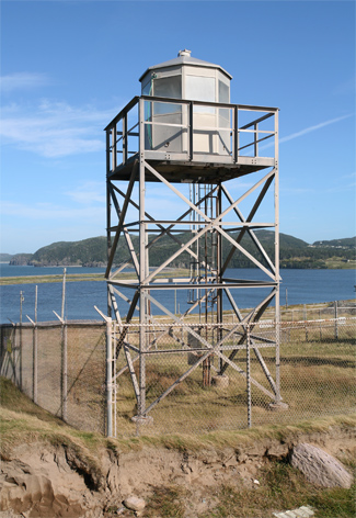
The Malpeque Harbour Approach Range Lights are a set of range lights on Prince Edward Island, Canada. The current rear tower was built in 1961.

<span class="mw-page-title-main">Murray Harbour Range Lights</span> Lighthouse

The Murray Harbour Range Lights are a set of range lights near Murray Harbour, Prince Edward Island, Canada. They were built in 1879, and are still active.

The history of lighthouses in Canada dates to 1734.

<span class="mw-page-title-main">Cape Bonavista Light</span> Lighthouse

Cape Bonavista Light is a lighthouse located on Cape Bonavista, Newfoundland. The lighthouse, which operated from 1843 until 1962, is now a provincial museum, containing an exhibition about life in a lighthouse during the 1870s.

<span class="mw-page-title-main">Cape Bowling Green Light</span> Lighthouse in Queensland, Australia

Cape Bowling Green Light is an active lighthouse on Cape Bowling Green, a long headland ending in a long low sandspit, about 30 kilometres (19 mi) from Ayr, Queensland, Australia. The lighthouse is at the end of the headland, near the base of the sandspit. The first lighthouse at the location, established in 1874, was moved multiple times. It was prefabricated in Brisbane, shipped to the location, moved twice due to coastal erosion and finally transferred for display at the Australian National Maritime Museum at Darling Harbour in Sydney.

<span class="mw-page-title-main">Entrance Island (British Columbia)</span> Lighthouse

Entrance Island is a small rocky island in the Strait of Georgia, 841 metres (2,759 ft) due north of Gabriola Island. Marine mammals such as harbour seals and Steller's sea lions use it as a haul-out.

<span class="mw-page-title-main">Cape Otway Lighthouse</span> Lighthouse

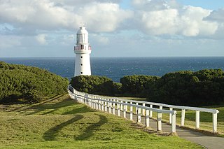
Cape Otway Lighthouse is a lighthouse on Cape Otway in southern Victoria, Australia. It is Victoria's oldest working lighthouse. During winter to spring, the lighthouse is a vantage point for land-based whale watching as migrating whales swim very close to shores.

<span class="mw-page-title-main">Trial Islands Lighthouse</span> Heritage-designated lighthouse near Victoria, BC

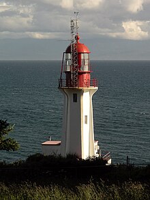
The major Trial Island is home to the Trial Islands Lighthouse which is operated by the Canadian Coast Guard, and continues to be staffed by two full-time lightkeepers. The current lighthouse was erected in 1970 to replace the original lighthouse that was constructed in 1906. The fourth order Fresnel lens from 1906 was used until it was replaced in 1970. That original lens is now on display courtesy of the Maritime Museum of British Columbia in Bastion Square in Downtown Victoria.

<span class="mw-page-title-main">Point Riche Lighthouse</span> Lighthouse

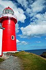
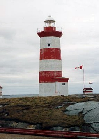
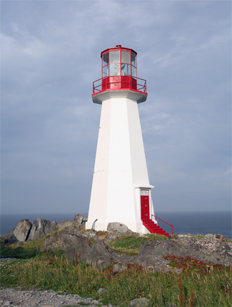
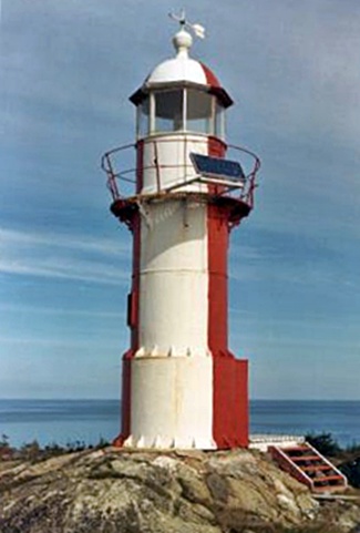
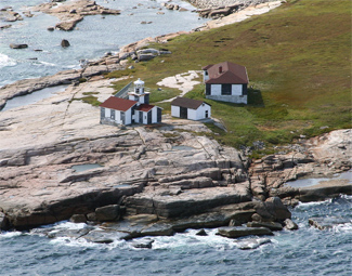
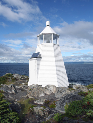
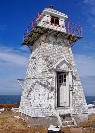
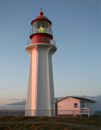
Point Riche Lighthouse, located in Port au Choix, Newfoundland in Canada's Newfoundland and Labrador province, is a "pepperpot" lighthouse that was built in 1892 and is still active. The white wooden tower is octagonal pyramidal in shape, the lantern room is painted red. The structure is 19 metres (62 ft) tall. Its light characteristic is a flash every 5 seconds, emitted at a focal plane height of 29 metres (95 ft). It is maintained by the Port au Choix National Historic Site.

<span class="mw-page-title-main">Cape Mudge Lighthouse</span> Lighthouse

Cape Mudge Lighthouse is located on Quadra Island which is off Campbell River, on the east coast of Vancouver Island, British Columbia, Canada.

<span class="mw-page-title-main">Dona Maria Pia Lighthouse</span> Lighthouse

Farol de Dona Maria Pia is a lighthouse at the southernmost point of the island of Santiago, Cape Verde. It stands on the headland Ponta Temerosa, at the entrance of Praia Harbour, 2 km south of the city centre of Praia. The lighthouse was built in 1881 and was named after Maria Pia of Savoy, queen of Portugal at the time. The octagonal tower is 21 m high and its focal plane is 25 m above mean sea level. It is painted white. The lighthouse is used for navigational purposes.

References

  1. Beverly Shaffer (1977). "Beautiful Lennard Island" (Requires Adobe Flash). Documentary film. National Film Board of Canada . Retrieved 12 January 2011.
  2. "Lighthouses of British Columbia". fogwhistle.ca. Archived from the original on 2 August 2010. Retrieved 8 August 2010.
  3. Rowlett, Russ. "Lighthouses of Canada: Southern British Columbia". The Lighthouse Directory. University of North Carolina at Chapel Hill.
  4. 1 2 Rowlett, Russ. "Lighthouses of Canada: Labrador and Belle Isle". The Lighthouse Directory. University of North Carolina at Chapel Hill . Retrieved 2017-02-05.
  5. 1 2 3 4 5 6 7 8 9 10 11 12 13 14 15 16 17 18 19 20 21 22 23 24 List of Lights, Pub. 110: Greenland, The East Coasts of North and South America (Excluding Continental U.S.A. Except the East Coast of Florida) and the West Indies (PDF). List of Lights . United States National Geospatial-Intelligence Agency. 2015.
  6. Rowlett, Russ. "Lighthouses of Canada: Southwestern Newfoundland". The Lighthouse Directory. University of North Carolina at Chapel Hill . Retrieved 2017-02-10.
  7. Rowlett, Russ. "Lighthouses of Canada: Southeastern Newfoundland". The Lighthouse Directory. University of North Carolina at Chapel Hill . Retrieved 2017-02-10.
  8. Rowlett, Russ. "Lighthouses of Canada: Southeastern Newfoundland". The Lighthouse Directory. University of North Carolina at Chapel Hill . Retrieved 2017-02-14.
  9. Rowlett, Russ. "Lighthouses of Canada: Southwestern Newfoundland". The Lighthouse Directory. University of North Carolina at Chapel Hill . Retrieved 2017-02-14.
  10. Rowlett, Russ. "Lighthouses of Canada: Southeastern Newfoundland". The Lighthouse Directory. University of North Carolina at Chapel Hill . Retrieved 2017-02-15.
  11. Rowlett, Russ. "Lighthouses of Canada: Southwestern Newfoundland". The Lighthouse Directory. University of North Carolina at Chapel Hill . Retrieved 2017-02-15.
  12. Lighthouses in New Brunswick Archived 2016-03-04 at the Wayback Machine , List of lighthouses in New Brunswick.
  13. Rowlett, Russ. "Lighthouses of Canada: Southern New Brunswick". The Lighthouse Directory. University of North Carolina at Chapel Hill . Retrieved 8 August 2016.
  14. Rowlett, Russ. "Lighthouses of Canada: Northern New Brunswick". The Lighthouse Directory. University of North Carolina at Chapel Hill . Retrieved 8 August 2016.
  15. Complete list of lighthouses at the Nova Scotia Lighthouse Preservation Society
  16. Andrew Sutherland
  17. "Lake Huron (North and East) Lighthouses". lighthousesrus.org. Archived from the original on 11 June 2008. Retrieved 8 August 2010.
  18. "Lake Ontario Lighthouses". lighthousesrus.org. Archived from the original on 4 June 2010. Retrieved 8 August 2010.