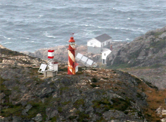
Bacalhao Island

Last updated

Bacalhao Island Lighthouse
Bacalhao Island
LocationBacalhao Island
Newfoundland
Canada
Coordinates 49°41′12.8″N54°33′24.4″W / 49.686889°N 54.556778°W / 49.686889; -54.556778
Tower
Constructed1894
Constructioncast iron tower
Height10 metres (33 ft)
Shapecylindrical tower with balcony and lantern
Markingswhite and red spiral stripes
OperatorCanadian Coast Guard [1] [2]
Heritagerecognized federal heritage building of Canada  OOjs UI icon edit-ltr-progressive.svg
Fog signal 1 blast every 30s.
Light
Focal height108.8 metres (357 ft)
Lenssixth-order Fresnel lens
Range17 nautical miles (31 km; 20 mi)
Characteristic Fl W 10s.

Bacalieu Island is an island off Twillingate in Newfoundland. It has a lighthouse. [3] In 1911, it was inhabited by the lighthouse keepers and their families.

Contents

See also

Related Research Articles

Hant's Harbour is an incorporated town located on the east side of Trinity Bay on the Bay de Verde Peninsula in the province of Newfoundland and Labrador, Canada. It has a population of 318 according to the 2021 Canadian census.

<span class="mw-page-title-main">Cape Ray</span> Lighthouse

Cape Ray is a headland located at the southwestern extremity of the island of Newfoundland in the Canadian province of Newfoundland and Labrador.

Cape Norman is a barren, limestone headland located at the northernmost point of insular Newfoundland in the Canadian province of Newfoundland and Labrador.

Cape Bauld is a headland located at the northernmost point of Quirpon Island, an island just northeast of the Great Northern Peninsula of Newfoundland in the Canadian province of Newfoundland and Labrador.

<span class="mw-page-title-main">Woody Point, Newfoundland and Labrador</span> Town in Newfoundland and Labrador, Canada

Woody Point is a town located in the heart of Gros Morne National Park, on the western coast of Newfoundland. Situated on Bonne Bay, the Town of Woody Point encompasses three areas: Curzon Village, Woody Point and Winterhouse Brook. It has a total population of 244 residents. Woody Point is a Registered Heritage District and has a waterfront with many heritage buildings and four Registered Newfoundland and Labrador Heritage Structures. The community is served by Route 431.

Garnish, a town located on the west coast of the Burin Peninsula, was well known for its lumbering and now for its lobstering operations. Located on Route 213, it is 25 km along route 220 north west of Grand Bank and 18 km along Route 220 east of Marystown. The Way Office was established in 1852 and the first Waymaster was Henry Campe. In 2021, the town had a population of 542.

<span class="mw-page-title-main">Reefs Harbour-Shoal Cove West-New Ferolle</span> Lighthouse

Reefs Harbour-Shoal Cove West-New Ferolle is a local service district and designated place in the Canadian province of Newfoundland and Labrador. It is southwest of Anchor Point.

Green Island is located in eastern Newfoundland off the east coast of the Bonavista Peninsula near the entrance to Catalina Harbour. The nearest town is Port Union.

<span class="mw-page-title-main">Lark Harbour</span> Town in Newfoundland and Labrador, Canada

Lark Harbour is small fishing community on the western coast of Newfoundland, on the south side of the Bay of Islands, and west of the City of Corner Brook.

<span class="mw-page-title-main">Burnt Islands, Newfoundland and Labrador</span> Town in Newfoundland and Labrador, Canada

Burnt Islands is a small coastal community found in God Bay on the southwest coast of Newfoundland, Canada.

<span class="mw-page-title-main">Fort Amherst, St. John's</span> Neighbourhood in St. Johns, Newfoundland and Labrador, Canada

Fort Amherst is a neighbourhood in St. John's, Newfoundland and Labrador. It is located at 47°33′48.96″N52°40′49.60″W, on the southern side of the Narrows, the entrance to St. John's harbour. Apart from some family dwellings, Fort Amherst consists of a man-made harbour, a lighthouse and the remains of gun emplacements built during World War II to defend against German U-boats. Two QF 4.7-inch B Mark IV* guns remain in place on their mountings.

Westport is a town in the Canadian province of Newfoundland and Labrador. The town had a population of 185 in 2021, down from 195 in the Canada 2016 Census.

<span class="mw-page-title-main">Cape St. Francis (Newfoundland and Labrador)</span> Lighthouse

The Headland of Cape St. Francis is outer extremity marking the boundary of Conception Bay on the Avalon Peninsula of the island of Newfoundland in the Canadian province of Newfoundland and Labrador.

<span class="mw-page-title-main">Cape St. Mary's</span> Cape in southeast Newfoundland

The headland of Cape St. Mary's is located at the southern tip of the south-western arm of the Avalon Peninsula of the island of Newfoundland in the Canadian province of Newfoundland and Labrador.

<span class="mw-page-title-main">Long Point Lighthouse</span> Lighthouse

Long Point Lighthouse is an active Canadian lighthouse located outside Crow Head on North Twillingate Island off the northeast coast of Newfoundland. The lighthouse, completed in 1876, attracts thousands of tourists each year and is historic to the town of Twillingate.

<span class="mw-page-title-main">Lobster Cove, Newfoundland and Labrador</span> Lighthouse

Lobster Cove is a fishing village near Rocky Harbour, Newfoundland.

Pushthrough is a resettled fishing community located on Newfoundland and Labrador's south coast, about 20 km northwest of Hermitage. Permanent settlement at Pushthrough happened in 1814, when George Chambers moved there from Gaultois to establish a fishing room and later a store. The community lost population to Gaultois in the 1950s and to Head of Bay d'Espoir in the 1960s. In 1968, virtually all the families with school aged children moved, effectively leading to the downfall of the community.

<span class="mw-page-title-main">Fox Point, Newfoundland and Labrador</span> Lighthouse

Fox Point is a settlement in Newfoundland and Labrador.

Division No. 1, Subdivision B is an unorganized subdivision on the Avalon Peninsula in Newfoundland and Labrador, Canada. It is in Division 1 and contains the unorganized communities of Iona, Little Barasway, Placentia Junction, Point Verde and Ship Harbour.

References

  1. Rowlett, Russ. "Lighthouses of Canada: Southwestern Newfoundland". The Lighthouse Directory. University of North Carolina at Chapel Hill . Retrieved 2017-02-05.
  2. List of Lights, Pub. 110: Greenland, The East Coasts of North and South America (Excluding Continental U.S.A. Except the East Coast of Florida) and the West Indies (PDF). List of Lights . United States National Geospatial-Intelligence Agency. 2016.
  3. "Bacalhao Island Lighthouse". Lighthousefriends.com. Lightouse Friends. Retrieved 5 June 2017.

Coordinates: 49°41′12.8″N54°33′24.4″W / 49.686889°N 54.556778°W / 49.686889; -54.556778