Territorial evolution of California

Last updated
Before 1768: An enlargeable territorial map of California tribal groups and languages prior to European contact. California tribes & languages at contact.png
Before 1768: An enlargeable territorial map of California tribal groups and languages prior to European contact.
Before 1768: An enlargeable map of the world showing the dividing lines for; Pope Alexander VI's Inter caetera papal bull (1493), the Treaty of Tordesillas (1494), and the Treaty of Saragossa (1529). Spain and Portugal.png
Before 1768: An enlargeable map of the world showing the dividing lines for; Pope Alexander VI's Inter caetera papal bull (1493), the Treaty of Tordesillas (1494), and the Treaty of Saragossa (1529).
Spanish period: An enlargeable map of the United States after the Treaty of Paris in 1783. United States 1789-03-1789-08.png
Spanish period: An enlargeable map of the United States after the Treaty of Paris in 1783.
Spanish period: An enlargeable map of the United States after the Adams-Onis Treaty took effect in 1821. United States 1821-07-1821-08.png
Spanish period: An enlargeable map of the United States after the Adams–Onís Treaty took effect in 1821.
Mexican period: An enlargeable map showing Alta California Territory (black) after the 1824 Constitution of Mexico. Mapa de Mexico 1824 3.PNG
Mexican period: An enlargeable map showing Alta California Territory (black) after the 1824 Constitution of Mexico.
Mexican period: Political divisions of Mexico as altered by Las Siete Leyes. Political divisions of Mexico 1836 (location map scheme).svg
Mexican period: Political divisions of Mexico as altered by Las Siete Leyes.
American period: An enlargeable map of the United States after the Treaty of Guadalupe Hidalgo in 1848. United States 1848-02-1848-05.png
American period: An enlargeable map of the United States after the Treaty of Guadalupe Hidalgo in 1848.
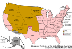
American period: An enlargeable map of the United States after the Compromise of 1850. United States 1850-1853-03.png
American period: An enlargeable map of the United States after the Compromise of 1850.
American period: The Nataqua Territory extension into California (light yellow), and Nevada's Roop County claim (light yellow area plus area outlined in green). Nataqua Territory map.png
American period: The Nataqua Territory extension into California (light yellow), and Nevada's Roop County claim (light yellow area plus area outlined in green).
American period: An enlargeable map of the United States as it has been since 1959. United States 1959-08-present.png
American period: An enlargeable map of the United States as it has been since 1959.

The following timeline traces the territorial evolution of California, the thirty-first state admitted to the United States of America, including the process of removing Indigenous Peoples from their native lands, or restricting them to reservations.

Contents

Timeline [lower-alpha 1]

Indigenous & territorial claims prior to 1768

Spanish period (1768–1821)

Mexican period (1821–1848)

American period (1848–present)

California Constitutional Boundaries

CONSTITUTION OF THE STATE OF CALIFORNIA (1849)

Article XII; Boundary

The Boundary of the State of California shall be as follows:
Commencing at this point of intersection of 42d degree of north latitude with the 120th degree of longitude west from Greenwich, and running south on the line of said 120th degree of west longitude until it intersects the 39th degree of north latitude; thence running in a straight line in a south easterly direction to the River Colorado, at a point where it intersects the 35th degree of north latitude; thence down the middle of the channel of said river, to the boundary line between the United States and Mexico, as established by the Treaty of May 30th, 1848; thence running west and along said boundary line to the Pacific Ocean, and extending therein three English miles; thence running in a northwesterly direction, and following the direction of the Pacific Coast to the 42d degree of north latitude, thence on the line of said 42d degree of north latitude to the place of beginning. Also all the islands, harbors, and bays, along adjacent to the Pacific Coast.

See also

Flag of Arizona.svg Territorial evolution of Arizona
Flag of Nevada.svg Territorial evolution of Nevada
Flag of Oregon.svg Territorial evolution of Oregon

Related Research Articles

<span class="mw-page-title-main">Alta California</span> Former province of New Spain and Mexico

Alta California, also known as Nueva California among other names, was a province of New Spain formally established in 1804. Along with the Baja California peninsula, it had previously comprised the province of Las Californias, but was made a separate province in 1804. Following the Mexican War of Independence, it became a territory of Mexico in April 1822 and was renamed Alta California in 1824.

<span class="mw-page-title-main">History of California before 1900</span> Native inhabitants, European exploration and colonization

Human history in California began when indigenous Americans first arrived some 13,000 years ago. Coastal exploration by the Spanish began in the 16th century, with further European settlement along the coast and in the inland valleys following in the 18th century. California was part of New Spain until that kingdom dissolved in 1821, becoming part of Mexico until the Mexican–American War (1846–1848), when it was ceded to the United States under the terms of the 1848 Treaty of Guadalupe Hidalgo. The same year, the California Gold Rush began, triggering intensified U.S. westward expansion. California joined the Union as a free state via the Compromise of 1850. By the end of the 19th century, California was still largely rural and agricultural, with a population of about 1.4 million.

<span class="mw-page-title-main">Adams–Onís Treaty</span> Treaty ceding Spanish Florida to the U.S. (1819)

The Adams–Onís Treaty of 1819, also known as the Transcontinental Treaty, the Spanish Cession, the Florida Purchase Treaty, or the Florida Treaty, was a treaty between the United States and Spain in 1819 that ceded Florida to the U.S. and defined the boundary between the U.S. and Mexico. It settled a standing border dispute between the two countries and was considered a triumph of American diplomacy. It came during the successful Latin American wars of independence against Spain.

<span class="mw-page-title-main">New Mexico Territory</span> Territory of the United States of America (1850–1912)

The Territory of New Mexico was an organized incorporated territory of the United States from September 9, 1850, until January 6, 1912. It was created from the U.S. provisional government of New Mexico, as a result of Nuevo México becoming part of the American frontier after the Treaty of Guadalupe Hidalgo. It existed with varying boundaries until the territory was admitted to the Union as the U.S. state of New Mexico. This jurisdiction was an organized, incorporated territory of the US for nearly 62 years, the longest period of any territory in the contiguous United States.

<span class="mw-page-title-main">Mexican Cession</span> Land the U.S. acquired from Mexico following the war in 1848

The Mexican Cession is the region in the modern-day southwestern United States that Mexico originally controlled, then ceded to the United States in the Treaty of Guadalupe Hidalgo in 1848 after the Mexican–American War. This region had not been part of the areas east of the Rio Grande that had been claimed by the Republic of Texas, though the Texas annexation resolution two years earlier had not specified the southern and western boundary of the new state of Texas. At roughly 529,000 square miles (1,370,000 km2), the Mexican Cession was the third-largest acquisition of territory in U.S. history, surpassed only by the 827,000-square-mile (2,140,000 km2) Louisiana Purchase and the 586,000-square-mile (1,520,000 km2) Alaska Purchase.

<span class="mw-page-title-main">Old Spanish Trail (trade route)</span> United States historic place

The Old Spanish Trail is a historical trade route that connected the northern New Mexico settlements of Santa Fe, New Mexico with those of Los Angeles, California and southern California. Approximately 700 mi (1,100 km) long, the trail ran through areas of high mountains, arid deserts, and deep canyons. It is considered one of the most arduous of all trade routes ever established in the United States. Explored, in part, by Spanish explorers as early as the late 16th century, the trail was extensively used by traders with pack trains from about 1830 until the mid-1850s. The area was part of Mexico from Mexican independence in 1821 to the Mexican Cession to the United States in 1848.

<span class="mw-page-title-main">History of California</span>

The history of California can be divided into the Native American period, the European exploration period (1542–1769), the Spanish colonial period (1769–1821), the Mexican period (1821–1848), and United States statehood. California was one of the most culturally and linguistically diverse areas in pre-Columbian North America. After contact with Spanish explorers, many of the Native Americans died from foreign diseases. Finally, in the 19th century there was a genocide by United States government and private citizens, which is known as the California genocide.

<span class="mw-page-title-main">The Californias</span> Region of the North America continent

The Californias, occasionally known as The Three Californias or Two Californias, are a region of North America spanning the United States and Mexico, consisting of the U.S. state of California and the Mexican states of Baja California and Baja California Sur. Historically, the term Californias was used to define the vast northwestern region of Spanish America, as the Province of the Californias, and later as a collective term for Alta California and the Baja California Peninsula.

<span class="mw-page-title-main">Ranchos of California</span> Land concessions by Spain and land grants by Mexico in the 18th and 19th centuries in California

The Spanish and Mexican governments made many concessions and land grants in Alta California and Baja California from 1775 to 1846. The Spanish Concessions of land were made to retired soldiers as an inducement for them to settle in the frontier. These Concessions reverted to the Spanish crown upon the death of the recipient.

<span class="mw-page-title-main">History of Hispanic and Latino Americans in the United States</span> History of Hispanics & Latinx in U.S.

The history of Hispanics and Latinos in the United States is wide-ranging, spanning more than four hundred years of American colonial and post-colonial history. Hispanics became the first American citizens in the newly acquired Southwest territory after the Mexican–American War, and remained a majority in several states until the 20th century.

<span class="mw-page-title-main">Yerba Buena, California</span> Original name of the Spanish settlement which became San Francisco, California, US

Yerba Buena was the original name of the settlement that later became San Francisco. Located near the northeastern end of the San Francisco Peninsula, between the Presidio of San Francisco and the Mission San Francisco de Asís, it was originally intended as a trading post for ships visiting San Francisco Bay. The settlement was arranged in the Spanish style around a plaza that remains as the present day Portsmouth Square.

<span class="mw-page-title-main">Territorial evolution of New Mexico</span> Geographic chronology of New Mexico

The area currently occupied by the U.S. State of New Mexico has undergone numerous changes in occupancy and territorial claims and designations. This geographic chronology traces the territorial evolution of New Mexico.

<span class="mw-page-title-main">Outline of Wyoming territorial evolution</span>

The following outline traces the territorial evolution of the U.S. State of Wyoming.

<span class="mw-page-title-main">Outline of Oregon territorial evolution</span> Overview of and topical guide to Oregon territorial evolution

The following outline traces the territorial evolution of the U.S. state of Oregon.

<span class="mw-page-title-main">Territorial evolution of Utah</span>

The following timeline traces the territorial evolution of the U.S. State of Utah.

<span class="mw-page-title-main">Territorial evolution of Arizona</span> Review of the topic

The following timeline traces the territorial evolution of the U.S. State of Arizona.

<span class="mw-page-title-main">Territorial evolution of Nevada</span>

The following outline traces the territorial evolution of the U.S. State of Nevada.

<span class="mw-page-title-main">Baja California Territory</span> Mexican territory from 1824 to 1931

Baja California Territory was a Mexican territory from 1824 to 1931, that encompassed the Baja California peninsula of present-day northwestern Mexico. It replaced the Baja California Province (1773–1824) of the Spanish colonial Viceroyalty of New Spain, after Mexican independence. Along with Alta California, the two territories were split from the Spanish Californias region.

<span class="mw-page-title-main">Rancho Las Camaritas</span> California land grant

Rancho Las Camaritas was an Alta California 18.57 acres land grant to José de Jesús Noé on January 21, 1840, by Governor Juan Bautista Alvarado. Millions of acres of California land was given at no charge to men between 1784 and 1846 by the Spanish (1784–1810) or Mexican governments (1819–1846) mostly for military service to raise cattle on. About 300 of the 800 Land grants were sizable varying from a few thousand to 1.5 million acres – see List of ranchos of California for the larger grants. Following the Mexican–American War, the land grants were challenged with most of them falling into American hands. Only one land grant has remained undeveloped. Las Camaritas' ownership was disputed in court by the U.S. government from 1856 until 1882 due to conflicting documentation presented by its American owner Ferdinand Vassault after a string of sales initiated by Jose Noe sometime between 1842 and 1846.

References

Footnotes

  1. Flag icons are shown each time a new national claim was made, or a new national flag was raised over California.

Citations

  1. State of California, Military Department. "Flags Over California: A History and Guide" (PDF). militarymuseum.org. California State Military Museums. Archived from the original (PDF) on 27 August 2020. Retrieved 27 August 2020.
  2. Yagi, George Jr. (5 September 2016). "The Attack on Monterey – Meet the Argentine Privateer Who Captured Spain's California Capital". Military History NOw. MilitaryHistoryNow.com. Archived from the original on 26 August 2020. Retrieved 26 August 2020.
  3. Thirty-first United States Congress (September 9, 1850). "An Act for the Admission of the State of California into the Union" (cgi-bin). Retrieved June 5, 2009.
  4. "State of CALIFORNIA, Plaintiff, v. State of NEVADA". Legal Information Institute. Cornell Law School. Retrieved 1 August 2020.