Lassen County is a county in the northeastern portion of the U.S. state of California. As of the 2020 census, the population was 32,730. The county seat and only incorporated city is Susanville. Lassen County comprises the Susanville, California, micropolitan statistical area. A former farming, mining and lumber area, its economy now depends on employment at one federal and two state prisons; the former in Herlong and the latter two in Susanville. In 2007, half the adults in Susanville worked in one of the facilities.

Modoc County is a county in the far northeast corner of the U.S. state of California. Its population is 8,700 as of the 2020 census, down from 9,686 from the 2010 census. This makes it California's third-least populous county. The county seat and only incorporated city is Alturas. Previous county seats include Lake City and Centerville. The county borders Nevada and Oregon.

The Territory of Nevada (N.T.) was an organized incorporated territory of the United States that existed from March 2, 1861, until October 31, 1864, when it was admitted to the Union as the State of Nevada.
Fredonyer Pass, elevation 5,751 feet (1,753 m), is a high mountain pass in Lassen County, California, southwest of Susanville and southeast of Mount Lassen. It lies on the Great Basin Divide between the Feather River to the west and the Susan River and Honey Lake to the east.

The Susan River is a northeastern California river of approximately 67 miles (108 km) length that drains from an arid plateau of volcanic highlands along the Great Basin Divide to intermittent Honey Lake. The river flows from eastern Lassen County from east of Lassen Volcanic National Park generally east past Susanville and emerging into a ranching valley to enter the north end of Honey Lake. Along with Fredonyer Pass, the Susan River is the northern boundary of the Sierra Nevada.

Eastern California is a region defined as either the strip to the east of the crest of the Sierra Nevada or as the easternmost counties of California.
Roop County, known until 1862 as Lake County, was a county of Nevada Territory in the United States from 1861 until 1864. It was created in 1861 as one of the original nine counties of Nevada. In 1864 it was succeeded by Lassen County, California and Washoe County, Nevada.
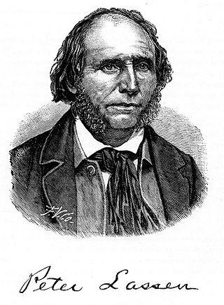
Peter Lassen, later known in Spanish as Don Pedro Lassen, was a Danish-born Californian ranchero and gold prospector. Born in Denmark, Lassen immigrated at age 30 to Massachusetts, before eventually finally moving to California. In California, Lassen became a Mexican citizen and received the vast Rancho Bosquejo from Governor Manuel Micheltorena. He is best known as the eponym of Lassen County, California, Lassen Peak, and Lassen Volcanic National Park.

Lassen National Forest is a United States national forest of 1,700 square miles (4,300 km2) in northeastern California. It is named after pioneer Peter Lassen, who mined, ranched and promoted the area to emigrant parties in the 1850s.

Area code 530 is a California telephone area code in northeastern and Northern California.

Isaac Newton Roop was a United States politician, pioneer and member of the Whig party. In 1859, he was the first elected (provisional) governor of the newly proposed Nevada Territory.

The 1872 California-Nevada State Boundary Marker marks the initial point for the 1872 survey delineation of the state line between California and Nevada. It is listed in the National Register of Historic Places.

The following timeline traces the territorial evolution of California, the thirty-first state admitted to the United States of America, including the process of removing Indigenous Peoples from their native lands, or restricting them to reservations.
There are 28 routes assigned to the "A" zone of the California Route Marker Program, which designates county routes in California. The "A" zone includes county highways in Lassen, Plumas, Shasta, Siskiyou, and Tehama counties.

Roop's Fort, also known as Roop's Trading Post, Fort Defiance, and Roop House, is a historic building in Susanville, California. The building, which was built in 1854 by Isaac Roop, was the first building built by white settlers in Lassen County. The fort was originally a trading post for westbound migrants and was the first post west of Fort Hall in Idaho. The building also served as the capitol of the short-lived Nataqua Territory, a territory created in 1856 to avoid California tax collectors. The territory was incorporated into Roop County, Nevada, named for Isaac Roop, in 1861. California and Nevada entered into a border dispute known as the Sagebrush War over the Susanville area in 1863, and Roop's Fort served as a fort for the Nevadans during the skirmish. California won the war, and Roop's Fort became part of Lassen County in 1864.
The Sagebrush War was an armed conflict between the California county of Plumas and the now-defunct Nevada County of Roop over the jurisdiction of Lake Honey Valley and Susanville, California.

The Von Schmidt State Boundary Monument was designated a California Historic Landmark (No.859) on April 26, 1973. In 1873 San Francisco civil engineer Allexey W. Von Schmidt built the State Boundary Monument in San Bernardino County, California near Needles, California. In 1872 and 1873 Von Schmidt did a survey of the border between California and Nevada/Arizona. The California Historic marker is on the dirt road, Pew Road, also called River Road, 2.6 Miles South of the State Line; 14 Miles North of Needles. The marker is not at the current state boundary, as Von Schmidt made an error in his survey. A new survey in 1893 showed that the Von Schmidt line was 1,600 to 1,800 feet off to the west. The marker is at the southern end of the California-Arizona State boundary. In 1872, a dispute arose between Nevada and California about the location of the state's boundary. Nevada wanted the state divide to be the same as the Sierra Nevada mountain range divide. California wanted the line to the east of the mountain range. When California attained statehood in 1850, it adopted 120 degrees west longitude as its eastern border. Between 1855 and 1900 there were six surveys to locate 120 degrees, with each locating 120 degrees of longitude differently. Von Schmidt applied for and was granted the contract to survey the state's frontier border east of the Sierra Nevada. In 1872 Von Schmidt using only a compass, a sextant and dead reckoning process set out with his crew to define the boundary. Von Schmidt was charged to measure and mark the boundary. Von Schmidt and his crew built stone markers and installed cast iron markers about one mile apart on the length of the state's boundary. Not many of the markers had foundations, so fewer remain today. A new survey in 1893 showed that the Von Schmidt line was 1,600 to 1,800 feet west of the actual 120 degrees. However, California and Nevada both recognize the 1872 Von Schmidt survey and the 1893 survey as the state line. Later the 1893 line was used. The exact location of the north-south California-Nevada border, between Lake Tahoe and the intersection of the southern boundary of Oregon at the 42nd parallel, was contentious and was surveyed and re-surveyed many time. One of the few iron markers that has survived is a near Verdi, Nevada this is a National Historic Landmark called the 1872 California-Nevada State Boundary Marker.
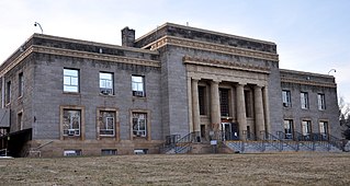
The Superior Court of California, County of Lassen, also known as the Lassen County Superior Court or Lassen Superior Court, is the branch of the California superior court with jurisdiction over Lassen County.

