
The area currently occupied by the U.S. State of New Mexico has undergone numerous changes in occupancy and territorial claims and designations. This geographic chronology traces the territorial evolution of New Mexico.
The area currently occupied by the U.S. State of New Mexico has undergone numerous changes in occupancy and territorial claims and designations. This geographic chronology traces the territorial evolution of New Mexico.


The Treaty of Guadalupe Hidalgo officially ended the Mexican–American War (1846–1848). It was signed on 2 February 1848 in the town of Guadalupe Hidalgo.

The Mexican Cession is the region in the modern-day Western United States that Mexico previously controlled, then ceded to the United States in the Treaty of Guadalupe Hidalgo in 1848 after the Mexican–American War. This region had not been part of the areas east of the Rio Grande that had been claimed by the Republic of Texas, which had been claiming independence since its Texas Revolution of 1836 and subsequent brief war for independence, followed afterwards a decade later by the American annexation and admitted statehood in 1845. It had not specified the southern and western boundary of the new state of Texas with New Mexico consisting of roughly 529,000 square miles (1,370,000 km2), not including any Texas lands, the Mexican Cession was the third-largest acquisition of territory in U.S. history, surpassed only by the 827,000-square-mile (2,140,000 km2) Louisiana Purchase of 1803 and the later 586,000-square-mile (1,520,000 km2) Alaska Purchase from Russia in 1867.

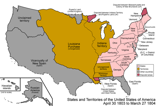
The District of Louisiana, or Louisiana District, was an official and temporary United States government designation for the portion of the Louisiana Purchase that had not been organized into the Territory of Orleans or "Orleans Territory". The district officially existed from March 10, 1804, until July 4, 1805, when it was organized as the Louisiana Territory.

The Territory of Missouri was an organized incorporated territory of the United States that existed from June 4, 1812, until August 10, 1821. In 1819, the Territory of Arkansas was created from a portion of its southern area. In 1821, a southeastern portion of the territory was admitted to the Union as the State of Missouri, and the rest became unorganized territory for several years.

The territory of the United States and its overseas possessions has evolved over time, from the colonial era to the present day. It includes formally organized territories, proposed and failed states, unrecognized breakaway states, international and interstate purchases, cessions, and land grants, and historical military departments and administrative districts. The last section lists informal regions from American vernacular geography known by popular nicknames and linked by geographical, cultural, or economic similarities, some of which are still in use today.

Louisiana, or the Province of Louisiana, was a province of New Spain from 1762 to 1801 primarily located in the center of North America encompassing the western basin of the Mississippi River plus New Orleans. The area had originally been claimed and controlled by France, which had named it La Louisiane in honor of King Louis XIV in 1682. Spain secretly acquired the territory from France near the end of the Seven Years' War by the terms of the Treaty of Fontainebleau (1762). The actual transfer of authority was a slow process, and after Spain finally attempted to fully replace French authorities in New Orleans in 1767, French residents staged an uprising which the new Spanish colonial governor did not suppress until 1769. Spain also took possession of the trading post of St. Louis and all of Upper Louisiana in the late 1760s, though there was little Spanish presence in the wide expanses of what they called the "Illinois Country".

The following outline is provided as an overview of and topical guide to the U.S. state of Kansas:

The following outline is provided as an overview of and topical guide to the U.S. state of Oklahoma:

The following outline is provided as an overview of and topical guide to Texas:

The following outline is provided as an overview of and topical guide to the U.S. state of Wyoming:

The following outline traces the territorial evolution of the U.S. State of Wyoming.
The following chronology traces the territorial evolution of the U.S. State of Montana.
The following timeline traces the territorial evolution of the U.S. State of Utah.
The following timeline traces the territorial evolution of the U.S. State of Arizona.

The following timeline traces the territorial evolution of California, the thirty-first state admitted to the United States of America, including the process of removing Indigenous Peoples from their native lands, or restricting them to reservations.
The following outline traces the territorial evolution of the U.S. State of North Dakota.
The following outline traces the territorial evolution of the U.S. State of South Dakota.

The 1763 Treaty of Paris ended the major war known by Americans as the French and Indian War and by Canadians as the Seven Years' War / Guerre de Sept Ans, or by French-Canadians, La Guerre de la Conquête. It was signed by Great Britain, France and Spain, with Portugal in agreement. Preferring to keep Guadeloupe, France gave up Canada and all of its claims to territory east of the Mississippi River to Britain. With France out of North America this dramatically changed the European political scene on the continent.
A Spanish military fort was constructed and occupied in 1819 near Sangre de Cristo Pass in the present U.S. State of Colorado to protect the Spanish colony of Santa Fe de Nuevo México from a possible invasion from the United States. The fort was the only Spanish settlement in present-day Colorado. The site of this fort is known today as the Spanish Fort.
| By country | |
|---|---|
| By former country | |
| By subdivision |
|
| By region |
|
| By country, people, region or period | |
| By international organisation | |