District of Louisiana

Last updated
District of Louisiana
Incorporated and unorganized territory of the United States
1804–1805
United States 1804-10-1805-01.png
A map of the District of Louisiana
Capital St. Louis
History
Government
Governor  
 1804–1805
William Henry Harrison
History 
 Established
October 1 1804
 Organized
July 4 1805
Preceded by
Succeeded by
Star-Spangled Banner flag.svg Louisiana Purchase
Territory of Louisiana Star-Spangled Banner flag.svg

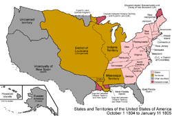
The District of Louisiana, or Louisiana District, was an official and temporary United States government designation for the portion of the Louisiana Purchase that had not been organized into the Territory of Orleans or "Orleans Territory" (the portion of the Louisiana Purchase south of the 33rd parallel, which is now the ArkansasLouisiana state line). The district officially existed from March 10, 1804, until July 4, 1805, when it was organized as the Louisiana Territory.

Contents

The area north of present-day Arkansas was commonly referred to as Upper Louisiana . The United States District of Louisiana had two incarnations: first, as a federally administered military district (March 10, 1804 - September 30, 1804); then as an organized territory (October 1, 1804 – July 4, 1805) under the jurisdiction of the Indiana Territory.

A similarly named "Louisiana District" had also previously been an administrative division under Spanish and French rule.

Military district of Louisiana (1804)

In legislation enacted October 31, 1803, Congress made provisions for a temporary government of the territory purchased from France. The president was authorized to use military forces to maintain order, although the local civil government was to continue as it had under French and Spanish rule. [1]

This military rule was in effect from March 10, 1804 the official date of transfer from French hands (known as Three Flags Day) until September 30, 1804. At this time, the district was further divided into five administrative divisions or districts: New Madrid, Cape Girardeau, Ste. Genevieve, St. Charles, and St. Louis.

Amos Stoddard served during this time as district commandant.

Civilian district of Louisiana (1804–1805)

On March 26, 1804, Congress enacted legislation effective October 1, 1804, that extended the authority of the governor and judges of the Indiana Territory to provide temporary jurisdiction over the District of Louisiana. [2]

Later that year, Indiana territorial governor William Henry Harrison and territorial judges Davis, Griffin, and Vandenberg held court in the district capital of St. Louis and enacted laws for the region.

On July 4, 1805, the District of Louisiana was re-designated as the Louisiana Territory (1805–1812), when it acquired its own territorial government, modeled on that of the Indiana Territory.

Inhabitants' concerns

Under the terms of the act establishing the temporary government, the governor and judges of the Indiana Territory were to meet twice a year in St. Louis. However, the settlers west of the Mississippi River complained strongly about the arrangement. Opposition was indicated by:

Upset citizens of the Louisiana District met in St. Louis in September 1804 to sign a declaration formally protesting the annexation. Among the signers were Auguste Chouteau. [3]

A notable event during this period was the signing of the Treaty of St. Louis, in which the Sac and Fox Indian tribes ceded northeastern Missouri, northern Illinois, and southern Wisconsin to the United States. Resentment over this treaty was to cause the tribes to side with the British during the War of 1812 in raids along the Missouri, Ohio, and Mississippi Rivers and was to spur the Black Hawk War in 1832.

On March 3, 1805, Congress enacted legislation organizing the District of Louisiana into the Louisiana Territory, effective July 4, 1805. The territorial government was organized similarly to that of the Indiana Territory. [4]

See also

Related Research Articles

<span class="mw-page-title-main">Louisiana Territory</span> Territory of the United States of America from 1805 to 1812

The Territory of Louisiana or Louisiana Territory was an organized incorporated territory of the United States that existed from July 4, 1805, until June 4, 1812, when it was renamed the Missouri Territory. The territory was formed out of the District of Louisiana, which consisted of the portion of the Louisiana Purchase north of the 33rd parallel.

<span class="mw-page-title-main">Territory of Orleans</span> Territory of the U.S. between 1804–1812

The Territory of Orleans or Orleans Territory was an organized incorporated territory of the United States that existed from October 1, 1804, until April 30, 1812, when it was admitted to the Union as the State of Louisiana.

<span class="mw-page-title-main">Indiana Territory</span> 1800–1816 territory of the United States

The Indiana Territory, officially the Territory of Indiana, was created by an organic act that President John Adams signed into law on May 7, 1800, to form an organized incorporated territory of the United States that existed from July 4, 1800, to December 11, 1816, when the remaining southeastern portion of the territory was admitted to the Union as the state of Indiana. The territory originally contained approximately 259,824 square miles (672,940 km2) of land, but its size was decreased when it was subdivided to create the Michigan Territory (1805) and the Illinois Territory (1809). The Indiana Territory was the first new territory created from lands of the Northwest Territory, which had been organized under the terms of the Northwest Ordinance of 1787. The territorial capital was the settlement around the old French fort of Vincennes on the Wabash River, until transferred to Corydon near the Ohio River in 1813.

<span class="mw-page-title-main">Historical regions of the United States</span>

The territory of the United States and its overseas possessions has evolved over time, from the colonial era to the present day. It includes formally organized territories, proposed and failed states, unrecognized breakaway states, international and interstate purchases, cessions, and land grants, and historical military departments and administrative districts. The last section lists informal regions from American vernacular geography known by popular nicknames and linked by geographical, cultural, or economic similarities, some of which are still in use today.

<span class="mw-page-title-main">Outline of Arkansas</span> Overview of and topical guide to Arkansas

The following outline is provided as an overview of and topical guide to the U.S. state of Arkansas:

<span class="mw-page-title-main">Outline of Montana</span> Overview of and topical guide to Montana

The following outline is provided as an overview of and topical guide to the U.S. state of Montana:

<span class="mw-page-title-main">Outline of Kansas</span> Overview of and topical guide to Kansas

The following outline is provided as an overview of and topical guide to the U.S. state of Kansas:

<span class="mw-page-title-main">Outline of Minnesota</span> Overview of and topical guide to Minnesota

The following outline is provided as an overview of and topical guide to the U.S. state of Minnesota:

<span class="mw-page-title-main">Outline of Missouri</span> Overview of and topical guide to Missouri

The following outline is provided as an overview of and topical guide to the U.S. state of Missouri:

<span class="mw-page-title-main">Outline of Nebraska</span> Overview of and topical guide to Nebraska

The following outline is provided as an overview of and topical guide to the U.S. state of Nebraska:

<span class="mw-page-title-main">Outline of North Dakota</span> Overview of and topical guide to North Dakota

The following outline is provided as an overview of and topical guide to the U.S. state of North Dakota:

<span class="mw-page-title-main">Outline of South Dakota</span> Overview of and topical guide to South Dakota

The following outline is provided as an overview of and topical guide to South Dakota:

<span class="mw-page-title-main">Outline of Wyoming</span> Overview of and topical guide to Wyoming

The following outline is provided as an overview of and topical guide to the U.S. state of Wyoming:

<span class="mw-page-title-main">Territorial evolution of New Mexico</span> Geographic chronology of New Mexico

The area currently occupied by the U.S. State of New Mexico has undergone numerous changes in occupancy and territorial claims and designations. This geographic chronology traces the territorial evolution of New Mexico.

<span class="mw-page-title-main">Outline of Wyoming territorial evolution</span>

The following outline traces the territorial evolution of the U.S. State of Wyoming.

<span class="mw-page-title-main">Territorial evolution of Montana</span>

The following chronology traces the territorial evolution of the U.S. State of Montana.

<span class="mw-page-title-main">Outline of North Dakota territorial evolution</span> Overview of and topical guide to North Dakota territorial evolution

The following outline traces the territorial evolution of the U.S. State of North Dakota.

<span class="mw-page-title-main">Territorial evolution of South Dakota</span>

The following outline traces the territorial evolution of the U.S. State of South Dakota.

References