This timeline is a chronology of significant events in the history of the U.S. State of New Mexico and the historical area that is now occupied by the state.
| Year | Date | Event |
|---|---|---|
| 2020 | November 3 | In the 2020 General Election, New Mexico voters elect five U.S. Presidential Electors for Joe Biden, elect Ben Ray Luján as new U.S. Senator, re-elect Deb Haaland and elect Yvette Herrell and Teresa Leger Fernandez as U.S. Representatives. Democrats retain control of the New Mexico Legislature. |
| April 2 | The 2020 United States Census enumerates the population of the State of New Mexico, estimated to be about 2,101,000. | |
| March 1 | COVID-19 has affected in New Mexico, which impacted the economy, culture, business, and the people of this state. [1] |
| Year | Date | Event |
|---|---|---|
| 1979 | January 1 | Bruce King assumes office as the twenty-fifth Governor of the State of New Mexico. |
| 1978 | November 10 | U.S. President Jimmy Carter signs the National Parks and Recreation Act of 1978 creating the Continental Divide National Scenic Trail. |
| 1976 | July 4 | The State of New Mexico celebrates the Bicentennial of the United States of America. |
| 1975 | January 1 | Jerry Apodaca assumes office as the twenty-fourth Governor of the State of New Mexico. |
| 1971 | January 1 | Bruce King assumes office as the twenty-third Governor of the State of New Mexico. |
| 1970 | April 1 | The 1970 United States Census enumerates the population of the State of New Mexico, later determined to be 1,017,055, an increase of 6.9% since the 1960 United States Census. New Mexico remains the 37th most populous of the 50 U.S. states. |
| Year | Date | Event |
|---|---|---|
| 1959 | January 1 | John Burroughs assumes office as the eighteenth Governor of the State of New Mexico. |
| 1957 | January 1 | Edwin L. Mechem assumes office as the seventeenth Governor of the State of New Mexico. |
| 1955 | January 1 | John F. Simms assumes office as the sixteenth Governor of the State of New Mexico. |
| 1954 | June 28 | U.S. President Dwight D. Eisenhower issues a proclamation creating Fort Union National Monument. [3] [2] |
| 1951 | January 1 | Edwin L. Mechem assumes office as the fifteenth Governor of the State of New Mexico. |
| 1950 | August 28 | U.S. President Harry S. Truman issues a Public Land Order abolishing Mesilla National Forest. [4] |
| April 1 | The 1950 United States Census enumerates the population of the State of New Mexico, later determined to be 681,187, an increase of 28.1% since the 1940 United States Census. New Mexico becomes the 39th most populous of the 48 U.S. states. |
| Year | Date | Event |
|---|---|---|
| 1947 | January 1 | Thomas J. Mabry assumes office as the fourteenth Governor of the State of New Mexico. |
| 1945 | September 2 | World War II ends as the Empire of Japan formally surrenders. |
| July 18 | The U.S. Army's Manhattan Project conducts the Trinity test, the first detonation of a nuclear weapon. The test is conducted in Socorro County on the Alamogordo Bombing Range. | |
| May 8 | The war in Europe ends as the Greater German Empire formally surrenders. | |
| 1944 | April 6 | U.S. President Franklin D. Roosevelt issues a Public Land Order creating Mesilla National Forest. [4] (Abolished August 28, 1950.) |
| 1943 | January 1 | John J. Dempsey assumes office as the thirteenth Governor of the State of New Mexico. |
| 1941 | December 11 | The United States declares war on the German Reich and the Italian Empire. |
| December 8 | The United States declares war on the Empire of Japan and enters World War II. | |
| 1940 | April 1 | The 1940 United States Census enumerates the population of the State of New Mexico, later determined to be 531,818, an increase of 25.6% since the 1930 United States Census. New Mexico becomes the 41st most populous of the 48 U.S. states and gains a 2nd Congressional seat. |
| Year | Date | Event |
|---|---|---|
| 1889 | spring | U.S. President Benjamin Harrison appoints L. Bradford Prince the thirteenth Governor of the Territory of New Mexico. |
| February 28 | The Territory of New Mexico founds the University of New Mexico. | |
| February 25 | The Territory of New Mexico creates Chaves County from a portion of Lincoln County. [11] | |
| 1888 | September 17 | Hiram Hadly establishes Las Cruces College. |
| 1887 | February 25 | The Territory of New Mexico creates Eddy County from a portion of Lincoln County. [11] |
| February 24 | The Territory of New Mexico creates San Juan County from a portion of Rio Arriba County. [11] | |
| 1885 | spring | U.S. President Grover Cleveland appoints Edmund G. Ross the twelfth Governor of the Territory of New Mexico. |
| 1884 | April 3 | The Territory of New Mexico creates Sierra County from portions of Doña Ana County and Socorro County. [11] |
| 1881 | July 14 | Sheriff Pat Garrett shoots to death Billy the Kid near Fort Sumner. |
| March 9 | U.S. President James A. Garfield appoints Lionel Allen Sheldon the eleventh Governor of the Territory of New Mexico. | |
| 1880 | November 12 | Territorial Governor Lew Wallace publishes Ben-Hur: A Tale of the Christ , the best-selling American novel of the 19th century. |
| April 1 | The 1880 United States Census enumerates the population of the Territory of New Mexico, later determined to be 119,565, an increase of 30.1% since the 1880 United States Census. New Mexico becomes the third most populous of the eight U.S. territories. |
| Year | Date | Event |
|---|---|---|
| 1878 | November 1 | The tracks of the Atchison, Topeka, and Santa Fe Railroad are built into New Mexico in the Raton Pass, the first railroad to reach the state. |
| September 29 | U.S. President Rutherford B. Hayes appoints Lew Wallace the tenth Governor of the Territory of New Mexico. | |
| 1876 | July 4 | The Territory of New Mexico celebrates the Centennial of the United States of America while still reeling from the defeat of Lieutenant Colonel George Armstrong Custer and the 7th Cavalry Regiment at the Battle of the Little Bighorn on June 26. |
| 1875 | July 30 | U.S. President Ulysses S. Grant appoints Samuel Beach Axtell the ninth Governor of the Territory of New Mexico. |
| 1871 | July 27 | U.S. President Ulysses S. Grant appoints Marsh Giddings the eighth Governor of the Territory of New Mexico. |
| 1870 | April 1 | The 1870 United States Census enumerates the population of the Territory of New Mexico, later determined to be 91,874, a decrease of -1.8% since the 1880 United States Census when the Territory of Arizona was still a part of the Territory of New Mexico. New Mexico becomes the most populous of the nine U.S. territories. |
| Year | Date | Event |
|---|---|---|
| 1869 | May 28 | U.S. President Ulysses S. Grant appoints William Anderson Pile the seventh Governor of the Territory of New Mexico. |
| January 25 | The Territory of New Mexico creates Colfax County from a portion of Mora County. [11] | |
| January 16 | The Territory of New Mexico creates Lincoln County from a portion of Socorro County. [11] | |
| 1868 | January 30 | The Territory of New Mexico creates Grant County from a portion of Doña Ana County. [11] |
| 1866 | January 15 | U.S. President Andrew Johnson appoints Robert Byington Mitchell the sixth Governor of the Territory of New Mexico. |
| 1865 | May 9 | U.S. President Andrew Johnson proclaims the end of the American Civil War. |
| 1863 | February 24 | U.S. President Abraham Lincoln signs An Act to provide a temporary Government for the Territory of Arizona, and for other Purposes. The act creates the Territory of Arizona from the portion of the Territory of New Mexico lying west of the 32nd meridian west from Washington (109°02′43″W). The boundaries of the Territory of New Mexico are now the same as the future State of New Mexico. |
| 1862 | June 19 | U.S. President Abraham Lincoln signs An Act to secure Freedom to all Persons within the Territories of the United States, granting freedom to the slaves in all U.S. territories including the Territory of New Mexico. |
| March 28 | Colorado volunteers under the command of Colonel John P. Slough repulse Texas cavalry under the command of Lieutenant Colonel William Read Scurry at the Battle of Glorieta Pass. The battle effectively ends the Confederate New Mexico Campaign and the Confederate Territory of Arizona. | |
| March 10 | Texas cavalry under the command of Brigadier General Henry Hopkins Sibley occupy Santa Fe in the Confederate New Mexico Campaign. | |
| February 24 | Confederate President Jefferson Davis proclaims that the portion of the Territory of New Mexico lying south of the 34th parallel north is the Confederate Territory of Arizona. | |
| 1861 | July 25 | Texas cavalry under the command of Lieutenant Colonel John R. Baylor invades the Territory of New Mexico and occupies the town of Mesilla. |
| May 24 | U.S. President Abraham Lincoln appoints Henry Connelly the fifth Governor of the Territory of New Mexico. | |
| April 12 | The American Civil War begins with the Battle of Fort Sumter. | |
| March 4 | Abraham Lincoln assumes office as the 16th President of the United States. | |
| February 28 | U.S. President James Buchanan signs the An Act to provide a temporary Government for the Territory of Colorado, creating the free Territory of Colorado. The Territory of Colorado annexes the portion of the Territory of New Mexico lying north of the 37th parallel north. The Territory of New Mexico now includes all of the future states of New Mexico and Arizona and the portion of the present-day State of Nevada lying south of the 37th parallel north. | |
| February 8 | The seven secessionist slave states create the Confederate States of America. | |
| 1860 | November 6 | Abraham Lincoln is elected President of the United States. Seven slave states will secede from the United States of America before February 8, 1861. |
| April 1 | The 1860 United States Census enumerates the population of the Territory of New Mexico, later determined to be 93,516, an increase of 51.9 since the 1850 United States Census. New Mexico becomes the second most populous of the seven U.S. territories. | |
| February 1 | The Territory of New Mexico creates Mora County from parts of Taos County and San Miguel County. [11] |
| Year | Date | Event |
|---|---|---|
| 1849 | October 23 | Brevet Colonel John Munroe assumes command as the fourth (and last) U.S. provisional governor of New Mexico. |
| March 12 | The Mormon settlers of the Great Salt Lake Valley create the Provisional Government of the State of Deseret and elect Brigham Young as the first (and only) Governor. The proposed state includes the entire Great Basin and the entire drainage basin of the Colorado River within the United States. Although the proposed State of Deseret includes the northwestern portion of the future State of New Mexico, it has no actual presence in the region. | |
| 1848 | October 11 | Brevet Lieutenant Colonel John M. Washington assumes command as the third U.S. provisional governor of New Mexico. |
| February 2 | The United States and United Mexican States sign the Treaty of Guadalupe Hidalgo to end the Mexican–American War. Mexico relinquishes its northern territories. All land in the future State of New Mexico north of the Mexican border becomes unorganized United States territory. | |
| 1847 | January 19 | U.S. civilian governor Charles Bent is killed by a band of insurgents at his home in Taos. First Secretary Donaciano Vigil assumes office as the second U.S. civilian governor of New Mexico. |
| 1846 | September 25 | General Stephen W. Kearny and troops depart for California. Colonel Sterling Price assumes command as the second U.S. military governor of New Mexico. |
| September 22 | Brigadier General Stephen W. Kearny appoints Charles Bent as the first U.S. civilian governor of New Mexico. | |
| August 22 | Brigadier General Stephen W. Kearny assumes command as the first U.S. military governor of New Mexico. | |
| August 18 | Troops under the command of General Stephen W. Kearny seize Santa Fe for the United States with little resistance. | |
| August 15 | U.S. Army troops under the command of Brigadier General Stephen W. Kearny enter Las Vegas, New Mexico. General Kearny proclaims that all of New Mexico is now under United States rule. | |
| May 13 | The United States declares war on the Mexican Republic. | |
| April 25 | The Thornton Affair becomes the first skirmish of the Mexican–American War. | |
| February 14 | The State of Texas cedes the territorial claims of the Republic of Texas to the United States. The boundaries of the State of Texas within that territory remain undefined. The United States now claims the Rio Grande as its border with Mexico. | |
| 1845 | December 29 | The United States admits the Republic of Texas to the Union as the slave State of Texas but declines to define its borders. The Mexican Republic maintains that Texas is still its territory by the Treaty of Limits of 1828 and states that it will fight to regain Texas. |
| November 16 | Manuel Armijo is appointed Gobernador de Santa Fe de Nuevo México for a third term. | |
| May 1 | José Chavéz y Castillo is appointed Gobernador de Santa Fe de Nuevo México. | |
| 1844 | June 17 | Santa Fe de Nuevo México is divided into three districts and 21 counties. The population is 67,736. [13] |
| March 30 | Mariano Martínez de Lejanza is appointed Gobernador de Santa Fe de Nuevo México. | |
| 1841 | October 5 | The Republic of Texas Santa Fe Expedition surrenders to Nuevo México troops under the command of Gobernador Manuel Armijo. |
| Year | Date | Event |
|---|---|---|
| 1837 | Manuel Armijo is appointed Gobernador de Santa Fe de Nuevo México for a second term. | |
| 1837 | March 6 | U.S. Secretary of State John Forsyth accepts the credentials of William H. Wharton as Republic of Texas Minister to the United States of America. Mexico protests the United States recognition of the Republic of Texas as a violation of the Treaty of Limits of 1828. |
| 1836 | May 14 | Texians force captured General Santa Anna to sign the coerced Treaties of Velasco recognizing the independence of the Republic of Texas. Mexico neither acknowledges nor ratifies these treaties. Based upon these treaties, the Republic of Texas claims all land north and east of the Rio Grande del Norte to the United States border and the 45th parallel north. The Republic of Texas never occupies the region west of the 100th meridian west and this western region remains in Mexican hands. The disputed region will later become portions of the future U.S. states of New Mexico, Texas, Oklahoma, Kansas, Colorado, and Wyoming. |
| May 2 | Texians (immigrants from the United States living in the Mexican state of Coahuila y Tejas) declare the independence of the Republic of Texas from Mexico. | |
| 1835 | October 2 | The Texian Revolt begins with the Battle of Gonzales. |
| 1835 | July | Albino Pérez is appointed Gobernador de Santa Fe de Nuevo México. |
| 1833 | Francisco Sarracino is appointed Gobernador de Santa Fe de Nuevo México. | |
| 1832 | Santiago Abreú is appointed Gobernador de Santa Fe de Nuevo México. |
| Year | Date | Event |
|---|---|---|
| 1828 | January 12 | The United States and Mexico sign the Treaty of Limits affirming the boundaries set by the Adams–Onís Treaty of 1819. |
| 1829 | September | José Antonio Chaves assumes office as the seventh Géfe político de Santa Fe de Nuevo México. |
| 1827 | May | Manuel Armijo assumes office as the sixth Géfe político de Santa Fe de Nuevo México. |
| 1825 | September | Antonio Narbona assumes office as the fifth Géfe político de Santa Fe de Nuevo México. |
| 1823 | August | Bartolomé Baca assumes office as the fourth Géfe político de Santa Fe de Nuevo México. |
| 1822 | November | José Antonio Vizcarra assumes office as the third Géfe político de Santa Fe de Nuevo México. |
| July 5 | Francisco Xavier Chávez assumes office as the second Géfe político de Santa Fe de Nuevo México. | |
| 1821 | December 26 | Spanish Gobernador Facundo Melgares receives orders that Santa Fe de Nuevo México is now an intendance of the Mexican Empire. Melgares swears fealty to the empire and becomes the first Mexican Géfe político de Santa Fe de Nuevo México. |
| September 1 | William Becknell and a party of frontier traders leave New Franklin, Missouri bound for Santa Fe by way of the upper Arkansas and Purgatoire rivers. The Becknell route will become the Mountain Branch of the Santa Fe Trail. | |
| August 24 | Ferdinand VII of Spain signs the Treaty of Córdoba recognizing the independence of the Mexican Empire. | |
| February 22 | The Adams–Onís Treaty of 1819 takes effect. The United States relinquishes all land in the future State of New Mexico. |
| Year | Date | Event |
|---|---|---|
| 1808 | Teniente coronel Don Jose Manrique is appointed Gobernador de Nuevo Méjico. | |
| 1807 | Don Alberto Maynez is appointed Gobernador de Nuevo Méjico. | |
| February 26 | Spanish cavalrymen arrest the U.S. Army reconnaissance expedition led by Captain Zebulon Pike in the San Luis Valley. The reconnaissance party will be taken to Santa Fe, then Chihuahua, before being expelled from Nueva España on July 1, 1807. | |
| 1805 | March 3 | U.S. President Thomas Jefferson signs An Act further providing for the government of the district of Louisiana. The District of Louisiana is reorganized as the self-governing Territory of Louisiana. The Territory of Louisiana includes the disputed northeastern portion of the future State of New Mexico in the Mississippi River watershed. |
| 1804 | October 1 | The District of Louisiana is organized under the jurisdiction of the Territory of Indiana. |
| Coronel Don Joaquín del Real Alencaster is appointed Gobernador de Nuevo Méjico. | ||
| March 26 | U.S. President Thomas Jefferson signs An Act erecting Louisiana into two territories, and providing for the temporary government thereof. The portion of the Louisiana Purchase north of the 33rd parallel north is designated the military District of Louisiana. | |
| 1803 | December 20 | France turns its colony of La Louisiane over to the United States. The United States and Spain disagree over the western boundary of the territory. The United States maintains that Louisiana includes the Mississippi River and its entire western drainage basin. Spain maintains that its territory includes (1) all land west of the Continental Divide of the Americas including Alta California, and (2) all land south of the Arkansas River and west of the Medina River including Santa Fe de Nuevo México, and (3) all land south of the Red River and west of the Calcasieu River including Tejas. The area in dispute includes the northeastern portion of the future State of New Mexico in the Mississippi River watershed. |
| April 30 | The United States and the French Republic sign the Louisiana Purchase Treaty. | |
| 1800 | October 1 | Under pressure from Napoléon Bonaparte, the Kingdom of Spain transfers the colony of la Luisiana back to the French Republic with the secret Third Treaty of San Ildefonso. |
| Year | Date | Event |
|---|---|---|
| 1793 | August 16 | Teniente coronel Don Fernando Chacón is appointed Gobernador de Nuevo Méjico. |
| 1792 | October 3 | French frontiersman Pierre "Pedro" Vial arrives in Saint-Louis from the Spanish settlement of Santa Fe. The route he followed will become the Cimarron Branch of the Santa Fe Trail. |
| Year | Date | Event |
|---|---|---|
| 1788 | Don Fernando de la Concha is appointed Gobernador de Nuevo Méjico. | |
| 1783 | September 3 | The Treaty of Paris is signed in Paris by representatives of King George III of Great Britain and representatives of the United States of America. The treaty affirms the independence of the United States and sets the Mississippi River as its western boundary. |
| Year | Date | Event |
|---|---|---|
| 1778 | Teniente coronel Don Juan Bautista de Anza is appointed Gobernador de Nuevo Méjico. | |
| Bernardo de Miera y Pacheco, cartographer for the Dominguez–Escalante Expedition, publishes his map of the expedition across the Colorado Plateau. His map becomes the foundation of a future trade route later known as the Old Spanish Trail. | ||
| Don Francisco Trebol Navarro is appointed Gobernador de Nuevo Méjico. | ||
| 1776 | July 29 | A Spanish-Franciscan expedition led by Franciscan priests Francisco Atanasio Domínguez and Silvestre Vélez de Escalante sets out from La Villa Real de la Santa Fé de San Francisco de Asís (Santa Fe) in search of an overland route to the Presidio Reál de San Carlos de Monterey (Monterey). The expedition follows the 1765 route of Juan Rivera northwest across the Colorado Plateau. The expedition fails to reach Las Californias, but reaches the lower Paria River in the future State of Arizona before returning to Santa Fe. |
| July 4 | Representatives of the thirteen United States of America sign the Declaration of Independence from the Kingdom of Great Britain. |
| Year | Date | Event |
|---|---|---|
| 1767 | Capitán Don Pedro Fermín de Mendinueta is appointed Gobernador de Nuevo Méjico. | |
| 1765 | July | Governor Don Tomás Vélez Cachupin dispatches an expedition led by Juan Maria Antonio Rivera to explore the San Juan Mountains and the Colorado Plateau. |
| 1762 | November 13 | Fearing the loss of its American territories in the Seven Years' War, the Kingdom of France transfers its colony of La Louisiane to the Kingdom of Spain with the secret Treaty of Fontainebleau. This ends the competition between France and Spain on the Great Plains. |
| 1761 | March 14 | King Charles III of Spain appoints Don Tomás Vélez Cachupin Gobernador de Nuevo Méjico for a second term. |
| 1760 | May 10 | Don Manuel de Portillo y Urrisola is appointed Gobernador de Nuevo Méjico. |
| King Charles III of Spain appoints Don Mateo Antonio de Mendoza Gobernador de Nuevo Méjico. |
| Year | Date | Event |
|---|---|---|
| 1754 | Don Francisco Antonio Marín del Valle is appointed Gobernador de Nuevo Méjico. |
| Year | Date | Event |
|---|---|---|
| 1749 | Don Tomás Vélez Cachupín is appointed Gobernador de Nuevo Méjico. | |
| 1743 | Don Joaquín Codallos y Rabal is appointed Gobernador de Nuevo Méjico. |
| Year | Date | Event |
|---|---|---|
| 1739 | July 5 | On a voyage up the Arkansas River to the confluence of the Purgatoire River, Pierre Antoine and Paul Mallet encounter an Arikara man who agrees to guide them to Santa Fe. This is the first contact between France and Spain in the Rocky Mountain region. |
| January | Don Gaspar Domingo de Mendoza is inaugurated as Gobernador de Nuevo Méjico. | |
| 1737 | May 12 | King Philip IV of Spain appoints Don Gaspar Domingo de Mendoza as Gobernador de Nuevo Méjico. |
| 1736 | Don Henrique de Olavide y Michelena is appointed Gobernador de Nuevo Méjico. | |
| 1731 | Don Gervasio Cruzat y Gongora is appointed Gobernador de Nuevo Méjico. |
| Year | Date | Event |
|---|---|---|
| 1722 | August | Don Juan Domingo de Bustamante is appointed Gobernador de Nuevo Méjico. |
| Year | Date | Event |
|---|---|---|
| 1717 | Capitán Don Antonio Valverde y Cosío is appointed Gobernador de Nuevo Méjico. | |
| Capitán Don Juan Paez Hurtado is appointed Gobernador de Nuevo Méjico. | ||
| 1715 | December 1 | Capitán Don Félix Martínez de Torrelaguna is inaugurated as Gobernador de Nuevo Méjico. |
| 1712 | October 5 | Don Juan Ignacio Flores Mogollon is inaugurated as Gobernador de Nuevo Méjico. |
| Year | Date | Event |
|---|---|---|
| 1707 | August | Almirante Don Jose Chacón Medina Salazar y Villaseñor is appointed Gobernador de Nuevo Méjico. |
| 1706 | April 23 | Gobernador Valdez establishes La Villa Real de San Francisco de Alburquerque on the Rio Grande. |
| 1705 | June | Don Francisco Cuervo y Valdez is appointed Gobernador de Nuevo Méjico. |
| 1704 | Capitán Don Don Juan Paez Hurtado is appointed Gobernador de Nuevo Méjico. | |
| 1703 | Diego de Vargas Zapata y Luján Ponce de León y Contreras is appointed Gobernador de Nuevo Méjico for a second term. |
| Year | Date | Event |
|---|---|---|
| 1697 | July 2 | Don Pedro Rodriguez Cubero is inaugurated as Gobernador de Nuevo Méjico. |
| 1692 | September 14 | Diego de Vargas Zapata y Luján Ponce de León y Contreras completes the reconquest of the Spanish colony of Santa Fe de Nuevo Méjico to end the Pueblo Revolt. |
| June 6 | King Charles II of Spain appoints Don Pedro Rodríguez Cubero Gobernador de Nuevo Méjico. Cubero delays his departure from Cuba on grounds of health. | |
| 1691 | February 22 | Diego de Vargas Zapata y Luján Ponce de León y Contreras is inaugurated as Gobernador de Nuevo Méjico at El Paso del Norte. |
| Year | Date | Event |
|---|---|---|
| 1689 | Capitán Don Domingo Jironza Petriz de Cruzate serves as Gobernador de Nuevo Méjico in exile | |
| 1688 | Diego de Vargas Zapata y Luján Ponce de León y Contreras is appointed Gobernador de Nuevo Méjico. | |
| 1686 | Don Pedro Reneros de Posada is appointed Gobernador de Nuevo Méjico in exile. | |
| 1683 | Capitán Don Domingo Jironza Petriz de Cruzate is appointed Gobernador de Nuevo Méjico in exile. | |
| 1682 | April 9 | René-Robert Cavelier, Sieur de La Salle, claims the Mississippi River and its watershed for the Kingdom of France and names the region La Louisiane in honor of King Louis XIV. The Mississippi Basin is later determined to be the fourth most extensive on Earth and includes lands inhabited by hundreds of thousands of native peoples and lands previously claimed by Spain, France, and England. The Louisiane claim includes the northeast portion the future State of New Mexico in the Mississippi River watershed. This will set up a rivalry among native peoples, France, Spain, and eventually the United States in the area. |
| 1680 | August 13 | Tewa shaman Popé of Ohkay Owingeh leads the Pueblo Revolt against the Spanish rulers of Santa Fe de Nuevo Méjico. The Spanish settlers flee down the Rio Grande to El Paso del Norte. |
| Year | Date | Event |
|---|---|---|
| 1677 | Capitán Don Antonio de Otermín is appointed Gobernador de Nuevo Méjico. | |
| 1675 | Capitán Don Juan Francisco Treviño is appointed Gobernador de Nuevo Méjico. | |
| 1671 | General Don Juan Durán de Miranda is appointed Gobernador de Nuevo Méjico for a second term. |
| Year | Date | Event |
|---|---|---|
| 1668 | Capitán Don Juan de Medrano y Mesía is appointed Gobernador de Nuevo Méjico. | |
| 1665 | January 14 | Capitán Don Fernando de Villanueva y Armendaris is appointed Gobernador de Nuevo Méjico. |
| 1664 | Capitán Don Juan Durán de Miranda is appointed Gobernador de Nuevo Méjico. | |
| Capitán Don Tomé Domínguez de Mendoza is appointed Gobernador de Nuevo Méjico. | ||
| 1662 | March 6 | Governor Don Diego Dionisio de Peñalosa Briceño y Berdugo leads a military expedition in search of the legendary Quivira. |
| 1661 | Capitán Don Diego Dionisio de Peñalosa Briceño y Berdugo is appointed Gobernador de Nuevo Méjico. |
| Year | Date | Event |
|---|---|---|
| 1659 | July 11 | Capitán Don Bernardo López de Mendizábal is inaugurated as Gobernador de Nuevo Méjico. |
| 1656 | Capitán Don Juan Manso de Contreras is appointed Gobernador de Nuevo Méjico. | |
| 1653 | Don Juan de Samaniego y Díez de Ulzurrun Xaca y Roncal is appointed Gobernador de Nuevo Méjico. |
| Year | Date | Event |
|---|---|---|
| 1649 | Capitán Don Hernando de Ugarte y la Concha is appointed Gobernador de Nuevo Méjico. | |
| 1646 | June 18 | Capitán Don Luis de Guzmán y Figueroa is appointed Gobernador de Nuevo Méjico. |
| 1644 | Capitán Don Fernando de Argüello Carvajál is appointed Gobernador de Nuevo Méjico. | |
| 1642 | Capitán Don Alonso de Pacheco de Herédia is appointed Gobernador de Nuevo Méjico. | |
| 1641 | Autumn | Sargento Francisco Gomes assumes office as Gobernador de Nuevo Méjico on the death of Gobernador Valdés |
| March | General Don Juan Flores de Sierra y Valdés is appointed Gobernador de Nuevo Méjico. |
| Year | Date | Event |
|---|---|---|
| 1637 | April 18 | Capitán Don Luís de Rosas is inaugurated as Gobernador de Nuevo Méjico. |
| 1634 | November | Capitán Don Francisco Martínez de Baeza is appointed Gobernador de Nuevo Méjico. |
| 1632 | March | Capitán Don Francisco de la Mora y Ceballos is appointed Gobernador de Nuevo Méjico. |
| Year | Date | Event |
|---|---|---|
| 1629 | May 1 | Capitán Don Francisco Manuel de Silva Nieto is inaugurated as Gobernador de Nuevo Méjico. |
| 1625 | Almirante Don Felipe de Sotelo Osorio is appointed Gobernador de Nuevo Méjico. |
| Year | Date | Event |
|---|---|---|
| 1618 | Juan Álvarez de Eulate y Ladrón de Cegama is appointed Gobernador de Nuevo Méjico. | |
| 1614 | Almirante Don Don Bernardino de Ceballos is appointed Gobernador de Nuevo Méjico. | |
| 1610 | Governor Don Pedro de Peralta moves the capital of Santa Fe de Nuevo Méjico to La Villa Real de la Santa Fe de San Francisco de Asís. |
| Year | Date | Event |
|---|---|---|
| 1609 | Don Pedro de Peralta is appointed Gobernador de Nuevo Méjico. | |
| 1607 | Don Pedro de Peralta establishes La Villa Real de la Santa Fe de San Francisco de Asís at the Tiwa village of Ogapoge on the Santa Fe River. | |
| 1606 | Don Juan de Oñate y Salazar is recalled to México to answer charges to brutality against indigenous peoples. Don Cristóbal De Oñate assumes his father's office. |
| Year | Date | Event |
|---|---|---|
| 1598 | July 12 | Don Juan de Oñate y Salazar establishes the Virreinato de Nueva España colony of Santa Fe de Nuevo Méjico at the village of San Juan de los Caballeros adjacent to the Ohkay Owingeh Pueblo at the confluence of the Rio Grande and the Río Chama. The colony will eventually encompass most of the future U.S. states of New Mexico and Colorado and portions of Kansas, Oklahoma, Texas, Arizona, and Utah. |
| Year | Date | Event |
|---|---|---|
| 1541 | June 28 | A Spanish military expedition led by Hernando de Soto, Governor of Cuba, become the first Europeans to cross the Mississippi River. |
| spring | The military expedition led by Francisco Vásquez de Coronado leaves the Tiwa pueblos and searches the Great Plains for Quivira. | |
| winter | The Tiwa resist the occupation by the Coronado expedition but hundreds are killed in the Tiguex War. | |
| 1540 | autumn | The military expedition led by Francisco Vásquez de Coronado, reaches the Tiwa pueblos along the Río Bravo (Rio Grande). The expedition occupies several of the pueblos. |
| July 7 | The military expedition led by Francisco Vásquez de Coronado, reaches the Zuni pueblo of Hawikuh. The Zuni resist but are driven off by the Spanish soldiers. Fray Marcos de Niza returns to Compostela in disgrace. | |
| February 23 | Francisco Vásquez de Coronado, Governor of Nueva Galicia, departs Compostela, México commanding a Spanish military expedition of 400 soldiers, 1,300 to 2,000 Mexican Indian allies, four Franciscan friars including Marcos de Niza and Juan de Padilla, and several slaves. |
| Year | Date | Event |
|---|---|---|
| 1539 | September | Fray Marcos de Niza returns to San Miguel de Culiacán after a distant view of the Zuni pueblo of Hawikuh. His glowing reports of Hawikuh inspire the 1540-1542 expedition of Francisco Vásquez de Coronado. |
| March | Mustafa Azemmouri leaves San Miguel de Culiacán followed by Fray Marcos de Niza in search of the Seven Cities of Cibola. Mustafa Azemmouri is murdered at the Zuni pueblo of Hawikuh. | |
| 1536 | July | The four survivors of the Narváez expedition of 1527 arrive in Mexico City. Reports of their travels inspire stories of the Seven Cities of Cibola. |
| 1535 | The four survivors of the Narváez expedition of 1527: Álvar Núñez Cabeza de Vaca, Andrés Dorantes de Carranza, Alonso del Castillo Maldonado, and Mustafa Azemmouri (slave name: Estevanico), may have traveled through the southwestern portion of the future State of New Mexico. |
| Year | Date | Event |
|---|---|---|
| 1519 | Autumn | A Spanish naval expedition along the northeastern coast of Mexico charts the mouths of several rivers including the Río de Nuestra Señora (Rio Grande). |
| 1513 | September 29 | Spanish conquistador Vasco Núñez de Balboa crosses the Isthmus of Panama and arrives on the shore of a sea that he names Mar del Sur (the South Sea, later named the Pacific Ocean). He claims the sea and all adjacent lands for the Queen of Castile. This includes the portion of the future State of New Mexico west of the Continental Divide of the Americas. |
| Year | Date | Event |
|---|---|---|
| 1493 | May 5 | Pope Alexander VI (born Roderic de Borja in Valencia) issues the papal bull Inter caetera which splits the non-Christian world into two halves. The eastern half goes to the King of Portugal for his exploration, conquest, conversion, and exploitation. The western half (including all of North America) goes to the Queen of Castile and the King of Aragon for their exploration, conquest, conversion, and exploitation. The indigenous peoples of the Americas have no idea that any of these people exist. |
| 1492 | October 12 | Genoese seaman Cristòffa Cómbo (Christopher Columbus) leading an expedition for Queen Isabella I of Castile lands on the Lucayan island of Guanahani that he renames San Salvador. This begins the Spanish conquest of the Americas. |
| Era | Event |
|---|---|
| 1300–1525 CE | Jicarilla Apache migrate from Alaska and Northwestern Canada to the southern extent of the Rocky Mountains. |
| 1276–1299 CE | A prolonged drought on the Colorado Plateau forces many Ancestral Puebloans to migrate southeast into the Rio Grande Valley. |
| c. 9290 BCE | Paleo-Indians of the Clovis culture camp at Blackwater Draw. |
| c. 12,000 BCE | During a centuries long period of warming, ice-age Paleoamericans from Beringia begin using the ice-free corridor east of the Rocky Mountains to migrate throughout the Americas. |

The Territory of Louisiana or Louisiana Territory was an organized incorporated territory of the United States that existed from July 4, 1805, until June 4, 1812, when it was renamed the Missouri Territory. The territory was formed out of the District of Louisiana, which consisted of the portion of the Louisiana Purchase north of the 33rd parallel.

The Territory of New Mexico was an organized incorporated territory of the United States from September 9, 1850, until January 6, 1912. It was created from the U.S. provisional government of New Mexico, as a result of Nuevo México becoming part of the American frontier after the Treaty of Guadalupe Hidalgo. It existed with varying boundaries until the territory was admitted to the Union as the U.S. state of New Mexico. This jurisdiction was an organized, incorporated territory of the US for nearly 62 years, the longest period of any territory in the contiguous United States.

Pueblo of Isleta is an unincorporated community and Tanoan pueblo in Bernalillo County, New Mexico, United States, originally established in the c. 14th century. The Southern Tiwa name of the pueblo is Shiewhibak (Shee-eh-whíb-bak) meaning "a knife laid on the ground to play whib", a traditional footrace. Its people are a federally recognized tribe.
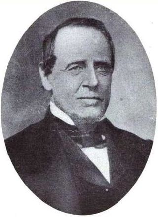
Henry Connelly was Governor of the New Mexico Territory during the American Civil War. He was appointed by President Lincoln and served from September 4, 1861, until July 6, 1866. During his term, the territory broke into two, and then three parts due to the Civil War and administrative problems.

New Mexico Territory's at-large congressional district is an obsolete congressional district representing the New Mexico Territory, which was created in 1850. After New Mexico's admission to the Union as the 47th state by act of Congress on January 6, 1912, this district was dissolved and replaced by New Mexico's at-large congressional district.

In the United States, a state is a constituent political entity, of which there are 50. Bound together in a political union, each state holds governmental jurisdiction over a separate and defined geographic territory where it shares its sovereignty with the federal government. Due to this shared sovereignty, Americans are citizens both of the federal republic and of the state in which they reside. State citizenship and residency are flexible, and no government approval is required to move between states, except for persons restricted by certain types of court orders.
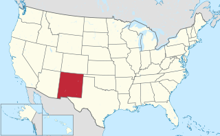
The area currently occupied by the U.S. State of New Mexico has undergone numerous changes in occupancy and territorial claims and designations. This geographic chronology traces the territorial evolution of New Mexico.

The following outline traces the territorial evolution of the U.S. State of Wyoming.
This timeline is a chronology of significant events in the history of the U.S. State of Colorado and the historical area now occupied by the state.
Admission to the Union is provided by the Admissions Clause of the United States Constitution in Article IV, Section 3, Clause 1, which authorizes the United States Congress to admit new states into the Union beyond the thirteen states that already existed when the Constitution came into effect. The Constitution went into effect on June 21, 1788, in the nine states that had ratified it, and the U.S. federal government began operations under it on March 4, 1789, when it was in effect in 11 out of the 13 states. Since then, 37 states have been admitted into the Union. Each new state has been admitted on an equal footing with those already in existence.

The Enabling Act of 1906, in its first part, empowered the people residing in Indian Territory and Oklahoma Territory to elect delegates to a state constitutional convention and subsequently to be admitted to the union as a single state.
An Act for the Admission of the State of California into the Union is the federal legislation that admitted California to the United States as the thirty-first state. California is one of only a few states to become a state without first being an organized territory.
This timeline is a chronology of significant events in the history of the U.S. State of Wyoming and the historical area now occupied by the state.
This timeline is a chronology of significant events in the history of the U.S. State of Montana and the historical area now occupied by the state.
This timeline is a chronology of significant events in the history of the U.S. State of Arizona and the historical area now occupied by the state.
This timeline is a chronology of significant events in the history of the U.S. State of Utah and the historical area now occupied by the state.
This timeline is a chronology of significant events in the history of the U.S. State of Idaho and the historical area now occupied by the state.
References are included in the linked articles.