
The Canadian Pacific Railway, also known simply as CPR or Canadian Pacific and formerly as CP Rail (1968–1996), is a Canadian Class I railway incorporated in 1881. The railway is owned by Canadian Pacific Kansas City Limited, known until 2023 as Canadian Pacific Railway Limited, which began operations as legal owner in a corporate restructuring in 2001.

The Kettle Valley Railway was a subsidiary of the Canadian Pacific Railway (CPR) that operated across southern British Columbia, west of Midway running to Rock Creek, then north to Myra Canyon, down to Penticton over to Princeton, Coalmont, Brookmere, Coquihalla and finally Hope where it connected to the main CPR line.

Field is an unincorporated community of approximately 169 people located in the Kicking Horse River valley of southeastern British Columbia, Canada, within the confines of Yoho National Park. At an elevation of 1,256 m (4,121 ft), it is 27 km (17 mi) west of Lake Louise along the Trans-Canada Highway, which provides the only road access to the town. The community is named for Cyrus West Field of Transatlantic telegraph cable fame, who visited the area in 1884.

The Selkirk locomotives were 36 steam locomotives of the 2-10-4 wheel arrangement built for Canadian Pacific Railway by Montreal Locomotive Works, Montreal in Quebec, Canada.

Rogers Pass is a high mountain pass through the Selkirk Mountains of British Columbia, but the term also includes the approaches used by the Canadian Pacific Railway (CP) and the Trans-Canada Highway. In the heart of Glacier National Park, this National Historic Site has been a tourist destination since 1886.
Field Hill is a steep portion of the mainline of the Canadian Pacific Kansas City located near Field, British Columbia. Field was created solely to accommodate the Canadian Pacific Railway's need for additional locomotives to be added to trains about to tackle both Field Hill, and the Big Hill. Here a stone roundhouse with turntable was built at what was first known simply as Third Siding. In December 1884 the CPR renamed it Field after Cyrus W. Field, a Chicago businessman who had visited recently on a special train.

The Connaught Tunnel is in southeastern British Columbia, on the Revelstoke–Donald segment. The 5.022-mile (8.082 km) tunnel carries the Canadian Pacific Kansas City (CPKC) main line under Mount Macdonald in the Selkirk Mountains. The tunnel, opened by the Canadian Pacific Railway (CP) in 1916, replaced the previous routing over Rogers Pass.
The Bessemer and Lake Erie Railroad was a class II railroad that operates in northwestern Pennsylvania and northeastern Ohio.

The Kicking Horse River is in the Canadian Rockies of southeastern British Columbia, Canada. The river was named in 1858, when James Hector, a member of the Palliser Expedition, reported being kicked by his packhorse while exploring the river. Hector named the river and the associated pass as a result of the incident. The Kicking Horse Pass, which connects through the Rockies to the valley of the Bow River, was the route through the mountains subsequently taken by the Canadian Pacific Railway when it was constructed during the 1880s. The railway's Big Hill and associated Spiral Tunnels are in the Kicking Horse valley and were necessitated by the steep rate of descent of the river and its valley.

Kicking Horse Pass is a high mountain pass across the Continental Divide of the Americas of the Canadian Rockies on the Alberta–British Columbia border, and lying within Yoho and Banff national parks. Divide Creek forks onto both sides of the Continental Divide.
The Mount Macdonald Tunnel is in southeastern British Columbia, on the Revelstoke–Donald segment. This single-track 14.66-kilometre (9.11 mi) tunnel, which carries the Canadian Pacific Kansas City (CPKC) main line under Mount Macdonald in the Selkirk Mountains, handles most westbound traffic, whereas the Connaught Tunnel handles mostly eastbound. The tunnel was opened by the Canadian Pacific Railway (CP) in 1988.

The Royal Hudsons are a series of semi-streamlined 4-6-4 "Hudson" type steam locomotives formerly owned and operated by the Canadian Pacific Railway (CPR) and built by Montreal Locomotive Works (MLW). The engines were built in 1937. In 1939, King George VI allowed the CPR to use the term after Royal Hudson number 2850 transported the royal train across Canada with no need of replacement. These locomotives were in service between 1937 and 1960. Four of them have been preserved. No. 2839 was used to power excursions for the Southern Railway Steam Program between 1979 and 1980. No. 2860 was used for excursion service in British Columbia between 1974 and 1999, then again between 2006 and 2010.

The Huron Central Railway is a railway operating in northern Ontario, Canada. It is operated by Genesee & Wyoming Canada, the Canadian subsidiary of Genesee & Wyoming.
The Toronto, Grey and Bruce Railway (TG&B) was a railway company which operated in Ontario, Canada in the years immediately following the Canadian Confederation of 1867. It connected two rural counties, Grey County and Bruce County, with the provincial capital of Toronto to the east.

The 1910 Rogers Pass Avalanche killed 58 men clearing a railroad line just outside of Revelstoke in Rogers Pass through the Selkirk Mountains in British Columbia on March 4, 1910. It is Canada's worst avalanche disaster.
John Edward Schwitzer was assistant chief engineer for the Canadian Pacific Railway in the early 1900s. He was known for two major projects on the CPR, both that removed costly bottlenecks on the routes.
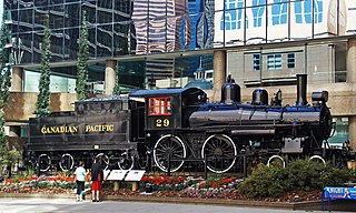
Canadian Pacific Railway No. 29 is a preserved Canadian A-1e class 4-4-0 steam locomotive. It was built by the Canadian Pacific's DeLorimier Shops in 1887 as locomotive No. 390, before being renumbered 277 in 1905. It was renumbered again to 29 after being rebuilt in 1912. By the 1950s, No. 29 was the youngest of three CPR 4-4-0s that were regularly used on the Norton-Chipman mixed train. After being retired from the Canadian Pacific in 1960, the locomotive was donated to the Canadian Railway Museum in Saint-Constant, Quebec for static display. In 1983, No. 29 was acquired by the Salem and Hillsborough Railway, and it was then moved to Hillsborough, New Brunswick, for further display. It was subsequently restored to operating condition for the locomotive's 100th birthday in 1987. In late 1994, No. 29 fell victim to a shed fire that would put an end to the locomotive's S&H career. Two years later, the locomotive was reacquired by the Canadian Pacific, who moved and cosmetically restored it for static display in front of their headquarters in Calgary, Alberta. In 2017, the locomotive was moved again to the CPR's new headquarters in Ogden yard. Although the locomotive is in good condition, an operational restoration on No. 29 would be expensive.
The history of the Canadian Pacific Railway dates back to 1873. Together with the Canadian Confederation, the creation of the Canadian Pacific Railway was a task originally undertaken as the "National Dream" by the Conservative government of Prime Minister John A. Macdonald. A key component of his National Policy, Macdonald was helped by Alexander Tilloch Galt, who was the owner of the North Western Coal and Navigation Company. British Columbia, a four-month sea voyage away from the East Coast, had insisted upon a land transport link to the East as a condition for joining Confederation, after initially requesting a wagon road.


