Spiral (railway)

Last updated
Spiral viaduct of the Bernina Express near Brusio, Switzerland. RhB ABe 4-4 III Kreisviadukt Brusio.jpg
Spiral viaduct of the Bernina Express near Brusio, Switzerland.

A spiral (sometimes called a spiral loop or just loop) is a technique employed by railways to ascend steep hills.

Contents

A railway spiral rises on a steady curve until it has completed a loop, passing over itself as it gains height, allowing the railway to gain vertical elevation in a relatively short horizontal distance. It is an alternative to a zig-zag, and avoids the need for the trains to stop and reverse direction while ascending. If the train is longer than the length of each loop it may be possible to view it looping above itself. [1] [2]

The term "loop" is also often used for a railway that curves sharply and goes back on itself: if the railway crosses itself, then it forms a spiral or helix; otherwise, it forms the much more common horseshoe curve or bend. [3] [4]

List of spirals

Argentina

Australia

Bulgaria

Canada

China

Guanjiao Spiral on Qinghai-Tibet Railway at night. The route containing the spiral was replaced by a 32-km long tunnel (at the time of completion the longest in China) in 2014. Xun Dao Gong Chu Pin photo by Xundaogong----Guan Jiao BMen  - panoramio.jpg
Guanjiao Spiral on Qinghai–Tibet Railway at night. The route containing the spiral was replaced by a 32-km long tunnel (at the time of completion the longest in China) in 2014.

Costa Rica

Replica of the Brusio Spiral Viaduct at 10°28′44″N84°49′25″W / 10.47900°N 84.82374°W / 10.47900; -84.82374 on the Tren Turistico Arenal, 10 km east of Nuevo Arenal, Guanacaste. [38] [39]

Croatia

Eritrea

France

Germany

India

Loop (Agony Point) on the DHR, India Agony point 1921.jpg
Loop (Agony Point) on the DHR, India

The Darjeeling Himalayan Railway originally had five or six spirals but only five in operation at any one time. The line also has six reverses or zig-zags. [56] [57]

Iran

Ireland

Italy

Japan

Okoba spiral and zig zag in Hisatsu Line, Japan Okoba spiral and zig zag aerial photography 1976-001.jpg
Okoba spiral and zig zag in Hisatsu Line, Japan
Spiral loop, west of Rainbow Bridge in Tokyo, Japan. 3 Chome Kaigan, Minato-ku, Tokyo-to 105-0022, Japan - panoramio (3).jpg
Spiral loop, west of Rainbow Bridge in Tokyo, Japan.

Kenya

There are three spirals on the 1,000 mm (3 ft 3+38 in) gauge railway line from Kenya to Uganda. This railway has been superseded by the Mombasa–Nairobi Standard Gauge Railway, which has removed the need for spirals by constructing tunnels and bridges. [73] [74] [75] [76]

Madagascar

Mexico

Myanmar

Spiral in Thazi - Taunggyi line, Myanmar Taunggyi line, Myanmar (Burma).jpg
Spiral in Thazi  Taunggyi line, Myanmar

New Zealand

Norway

Peru

Russia

Serbia

Slovakia

South Africa

South Korea

Geumdae 2nd Tunnel in Jungang Line, South Korea Jungang Line - Geumdae 2nd Tunnel 060606.JPG
Geumdae 2nd Tunnel in Jungang Line, South Korea

Spain

Sri Lanka

Switzerland

Toua spiral tunnel on the RhB Albulabahn Albulabahn01.jpg
Toua spiral tunnel on the RhB Albulabahn

Taiwan

Triple spiral loop on the Alishan Forest Railway Tunnel114.jpg
Triple spiral loop on the Alishan Forest Railway

Uganda

United Kingdom

The bridge on the spiral loop at Dduallt on the Ffestiniog Railway, Wales. Dduallt spiral simkins.jpg
The bridge on the spiral loop at Dduallt on the Ffestiniog Railway, Wales.

United States

Tehachapi Loop, on the Union Pacific Railroad, California, United States, viewed from the air. Tehachapi Loop USGS closeup.jpg
Tehachapi Loop, on the Union Pacific Railroad, California, United States, viewed from the air.
1903 view of Riflesight Notch loop, near Rollins Pass in Colorado Riflesight Notch 1903.PNG
1903 view of Riflesight Notch loop, near Rollins Pass in Colorado

See also

Related Research Articles

<span class="mw-page-title-main">Circle line (London Underground)</span> London Underground line

The Circle line is a spiral-shaped London Underground line, running from Hammersmith in the west to Edgware Road and then looping around central London back to Edgware Road. The railway is below ground in the central section and on the loop east of Paddington. Unlike London's deep-level lines, the Circle line tunnels are just below the surface and are of similar size to those on British main lines. Printed in yellow on the Tube map, the 17-mile (27 km) line serves 36 stations, including most of London's main line termini. Almost all of the route, and all the stations, are shared with one or more of the three other sub-surface lines, namely the District, Hammersmith & City and Metropolitan lines. On the Circle and Hammersmith & City lines combined, over 141 million passenger journeys were recorded in 2019.

<span class="mw-page-title-main">Piccadilly line</span> London Underground line

The Piccadilly line is a deep-level London Underground line running from the north to the west of London. It has two branches, which split at Acton Town, and serves 53 stations. The line serves Heathrow Airport, and some of its stations are near tourist attractions such as Piccadilly Circus and Buckingham Palace. The District and Metropolitan lines share some sections of track with the Piccadilly line. Printed in dark blue on the Tube map, it is the sixth-busiest line on the Underground network, with nearly 218 million passenger journeys in 2019.

<span class="mw-page-title-main">Rhaetian Railway</span> Swiss transport company

The Rhaetian Railway, abbreviated RhB, is a Swiss transport company that owns the largest network of all private railway operators in Switzerland. Headquartered in Chur, the RhB operates all the railway lines of the Swiss canton of Grisons, except for the line from Sargans to the cantonal capital, Chur, which are operated by Swiss Federal Railways (SBB CFF FFS), as well as the line from Disentis/Mustér to the Oberalp Pass and further on to Andermatt, Uri, which is operated by Matterhorn Gotthard Bahn (MGB). Inaugurated in 1888 and expanded from 1896 onwards in various sections, the RhB network is located almost entirely within Grisons, with one station across the Italian border at Tirano.

<span class="mw-page-title-main">Hairpin turn</span> Acute curve (often one of a series) in a road, especially on a steep incline

A hairpin turn is a bend in a road with a very acute inner angle, making it necessary for an oncoming vehicle to turn about 180° to continue on the road. It is named for its resemblance to a bent metal hairpin. Such turns in ramps and trails may be called switchbacks in American English, by analogy with switchback railways.

<span class="mw-page-title-main">Tehachapi Loop</span> Rail line spiral between the Central Valley and Mojave Desert

The Tehachapi Loop is a 3,779-foot-long spiral, or helix, on the Union Pacific Railroad Mojave Subdivision through Tehachapi Pass, of the Tehachapi Mountains in Kern County, south-central California. The line connects Bakersfield and the San Joaquin Valley to Mojave in the Mojave Desert.

<span class="mw-page-title-main">Boston, Revere Beach and Lynn Railroad</span>

The Boston, Revere Beach and Lynn Railroad was a 3 ft narrow-gauge passenger-carrying shortline railroad between East Boston and Lynn, Massachusetts, from 1875 to 1940. Part of the railroad's right of way now forms the outer section of the Massachusetts Bay Transportation Authority's Blue Line rapid transit service.

<span class="mw-page-title-main">Horseshoe curve</span> Roadbed that turns 180 degrees

A horseshoe curve is a class of climbing curve in a roadbed that reverses turn direction (inflection) twice on either side of a single tight curve that varies through an angle of about 180 degrees or more.

<span class="mw-page-title-main">Cincinnati, Lebanon and Northern Railway</span> Ohio railroad (1885–1926)

The Cincinnati, Lebanon and Northern Railway (CL&N) was a local passenger and freight-carrying railroad in the southwestern part of the U.S. state of Ohio, connecting Cincinnati to Dayton via Lebanon. It was built in the late 19th century to give the town of Lebanon and Warren County better transportation facilities. The railroad was locally known as the "Highland Route", since it followed the ridge between the Little and Great Miami rivers, and was the only line not affected by floods such as the Great Dayton Flood of 1913.

<span class="mw-page-title-main">Double-track railway</span> Route where trains traveling in each direction can quickly pass each other

A double-track railway usually involves running one track in each direction, compared to a single-track railway where trains in both directions share the same track.

<span class="mw-page-title-main">Wood Island station</span> Rapid transit station in Boston, Massachusetts, US

Wood Island station is an MBTA Blue Line rapid transit station located off Bennington Street in the Day Square section of East Boston, Boston, Massachusetts. The station is adjacent to and named for the former Wood Island Park, a once heavily used recreational area for East Boston residents. Most of the park was destroyed in the mid 1960s to expand Logan International Airport. It was built in 1952, replacing a pair of Boston, Revere Beach and Lynn Railroad stations that served the area.

<span class="mw-page-title-main">Caernarfon railway station</span>

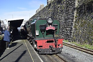
Caernarfon Station is the northern terminus of the narrow gauge Welsh Highland Railway, located in the town of Caernarfon. It was opened on 11 October 1997 when the line was constructed from Dinas.

<span class="mw-page-title-main">Nantlle Railway</span>

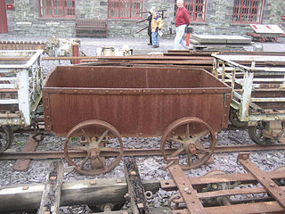
The Nantlle Railway was a Welsh narrow gauge railway. It was built to carry slate from several slate quarries across the Nantlle Valley to the harbour at Caernarfon for export by sea. The line provided a passenger service between Caernarfon and Talysarn from 1856 to 1865. It was the first public railway to be operated in North Wales.

<span class="mw-page-title-main">Colorado and Southern Railway</span> American Class I railroad

The Colorado and Southern Railway was an American Class I railroad in the western United States that operated independently from 1898 to 1908, then as part of the Chicago, Burlington and Quincy Railroad until it was absorbed into the Burlington Northern Railroad in 1981.

<span class="mw-page-title-main">Western River Railroad</span> Railroad at Tokyo Disneyland

The Western River Railroad is a 2 ft 6 in narrow gauge rail transport attraction in Tokyo Disneyland, which opened on April 15, 1983. Its route is 5,283 feet (1,610 m) long and takes guests through the Adventureland, Westernland, and Critter Country sections.

<span class="mw-page-title-main">Hex River Tunnels</span>

The four Hex River Tunnels consist of a twin tunnel of 0.5 kilometres and three single tunnels of 1.1 kilometres, 1.2 kilometres and 13.5 kilometres, on the Hexton railway route between De Doorns and Kleinstraat through the Hex River Mountains of the Western Cape Province, South Africa. The line, which connects De Doorns in the Hex River valley with Touws River in the Great Karoo, is part of the main rail route between Cape Town and Johannesburg. Of the 30 kilometres of track, 16.8 kilometres are underground. Construction of the line eliminated the bottleneck of the Hex River rail pass.

<span class="mw-page-title-main">Albula railway line</span> Railway line in canton of Graubünden, Switzerland

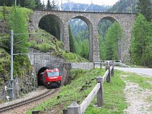
The Albula railway line is a single track metre gauge railway line forming part of the core network of the Rhaetian Railway (RhB), in the canton of Graubünden, Switzerland. It links Thusis on the Hinterrhein at 697 m (2,287 ft) and Filisur at 1,080 m (3,540 ft) with the spa resort of St. Moritz in Engadine at 1,774 m (5,820 ft).

<span class="mw-page-title-main">Septemvri–Dobrinishte narrow-gauge line</span>

The Septemvri–Dobrinishte narrow-gauge line is the only operating 760 mm narrow-gauge line in Bulgaria. It is operated by Bulgarian State Railways (BDŽ). The line is actively used with four passenger trains running the length of the line in each direction per day. The journey takes five hours through the valleys and gorges between the mountain ranges of Rila, Pirin and Rhodopes.

<span class="mw-page-title-main">Domodossola–Locarno railway line</span> Narrow gauge railway line in Switzerland and Italy

The Domodossola–Locarno railway line, informally called the Centovallina in Switzerland and the Vigezzina in Italy, is a metre-gauge railway negotiating the dramatic mountainous terrain between Domodossola, Italy, and Locarno, Switzerland. It passes through the Vigezzo Valley and Centovalli.

<span class="mw-page-title-main">Apsheronsk narrow-gauge railway</span> Railway in Krasnodar Krai, Russia

The Apsheronsk narrow-gauge railway is a mountain narrow-gauge railway located in Krasnodar Krai, Russia. It was opened in 1927 and built in the standard Russian narrow-gauge track gauge of 750 mm .

<span class="mw-page-title-main">Paddington tube station (Circle and Hammersmith & City lines)</span> London Underground station

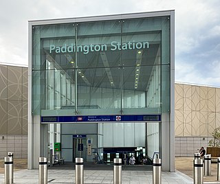
Paddington is a London Underground station served by the Circle and Hammersmith & City lines. It is located adjacent to the north side of Paddington mainline station and has entrances from within the mainline station and from Paddington Basin. The station is between Royal Oak and Edgware Road and is in London Fare Zone 1.

References

  1. Christian Wolmar (1 May 2014). The Iron Road: The Illustrated History of Railways. Dorling Kindersley Limited. pp. 170–. ISBN   978-0-241-18186-7.
  2. S. M. Yameen Nachsch (1972). Railway Engineering. Caravan Book House.
  3. William W. Hay (16 June 1982). Railroad Engineering. John Wiley & Sons. pp. 231–. ISBN   978-0-471-36400-9.
  4. Jim Harter (2005). World Railways of the Nineteenth Century: A Pictorial History in Victorian Engravings. JHU Press. ISBN   978-0-8018-8089-6.
  5. 1 2 3 John Brian Hollingsworth (1982). Atlas of the world's railways. Bison. ISBN   9780811904681.
  6. Axel Borsdorf; Christoph Stadel (12 March 2015). The Andes: A Geographical Portrait. Springer. pp. 273–. ISBN   978-3-319-03530-7.
  7. Pons, Mónica. "The Train to the Clouds, Salta". Welcome Argentina. Retrieved 13 December 2017.
  8. The Australian encyclopaedia. Michigan State University Press. 1958.
  9. "Bethungra Spiral". Heritage Council of New South Wales.
  10. "Cougal To Border Loop, Railway Spiral and Landscape". New South Wales State Heritage Register . Department of Planning & Environment . Retrieved 25 November 2017. CC BY icon.svg Text is licensed by State of New South Wales (Department of Planning and Environment) under CC-BY 4.0 licence .
  11. William Alan Bayley (1973). Standard Gauge Railway Across Australia. Austrail Publications. ISBN   978-0-909597-09-2.
  12. 1 2 3 4 Brendan Fox; et al. (2011). The Thomas Cook Rail Map of Europe (Map) (18th ed.). 1:4000000. Cartography by Mary Spence. Thomas Cook Publishing. ISBN   978-1-84848-356-9.
  13. 1 2 3 4 Ball, Mike (20 March 2017). European Railway Atlas Regional Series, Romania, Bulgaria and Moldova.
  14. 1 2 3 4 5 6 7 Ball, Mike (1 May 2016). European Railway Atlas.
  15. 1 2 3 Подробна карта на България (A detailed Map of Bulgaria) (Map). 1:380000. ДатаМап-Европа ООД (DataMap Europe). 2014. ISBN   978-954-519-036-0.
  16. Jane's World Railways. Sampson Low, Marston; New York: Rand McNally. 1960.
  17. Graeme Pole (1 January 1995). The Spiral Tunnels and the Big Hill: A Canadian Railway Adventure. Altitude Publishing Canada Limited. ISBN   978-1-55153-907-2.
  18. Barry D. Stewart (2004). Across the Land --a Canadian Journey of Discovery. Trafford Publishing. pp. 224–. ISBN   978-1-4120-2276-7.
  19. L.D. Cross (21 July 2014). High Peaks Engineering: Rocky Mountain Marvels. Heritage House Publishing Co. pp. 93–. ISBN   978-1-927527-80-1.
  20. Les Harding (5 February 2008). The Newfoundland Railway, 1898-1969: A History. McFarland. pp. 86–. ISBN   978-1-4766-0839-6.
  21. Heritage Foundation of Newfoundland and Labrador (January 2011). "Trinity Train Loop" . Retrieved 25 October 2017.
  22. Heritage Foundation of Newfoundland and Labrador. "Trinity Train Loop Registered Heritage Structure" . Retrieved 25 October 2017.
  23. Art Downs (1 May 1985). Incredible Rogers Pass. Heritage House Publishing Co. pp. 27–. ISBN   978-0-919214-08-8.
  24. "Long Tunnels". European Tribune. 12 June 2016. Retrieved 18 November 2020.
  25. "Qingshiya station". China Railway Map. Retrieved 26 August 2019.
  26. 1 2 3 4 5 Quail Map Company (2008). China Railway Atlas (third ed.). Quail Map Company. ISBN   978-1-898319-82-5.
  27. "Baishiyan station". China Railway Map. Retrieved 26 August 2019.
  28. "Lewu station". China Railway Map. Retrieved 26 August 2019.
  29. "Wazu station". China Railway Map. Retrieved 26 August 2019.
  30. "Tiekou station". China Railway Map. Retrieved 26 August 2019.
  31. "Ananzhuang station". China Railway Map. Retrieved 26 August 2019.
  32. "Longgudian station". China Railway Map. Retrieved 26 August 2019.
  33. "Daheba station". China Railway Map. Retrieved 26 August 2019.
  34. "Maocaoping station". China Railway Map. Retrieved 26 August 2019.
  35. "Duchuanzhai station". China Railway Map. Retrieved 26 August 2019.
  36. "Sanjiazhai station". China Railway Map. Retrieved 26 August 2019.
  37. Yuan Lei (2014-12-29). "袁蕾, 吐库二线正式开通运营 南疆铁路进入电气化时代 新疆日报" [Yuan Lei, spit library second-tier official opening and operation of the Southern Xinjiang Railway electrification into the Xinjiang Daily Times (Machine generated)] (in Chinese). Archived from the original on August 22, 2016. Retrieved 2016-07-04.
  38. Devereux, Nigel (September 2017). "Costa Rican rail variety". The Railway Magazine. Mortons Media Group Ltd.: 104.
  39. "Friends of Latin American Railways" . Retrieved 13 November 2018.
  40. 1 2 Ball, Mike (3 September 2017). European Railway Atlas Regional Series, The Balkans.
  41. 1 2 Benjaminse Uitgeverij BV (2013). A Travellers' Railway map of Europe (Map) (3rd ed.). 1:3800000. Cartography by Carto Studio BV. Benjaminse Uitgeverij BV. ISBN   978-90-77899-09-0.
  42. 1 2 3 4 5 Ball, Mike (15 July 2016). European Railway Atlas Regional Series, Italy.
  43. 1 2 Braun, Michel (April 2017). "The Col de Tende Line: A tortuous route and history". Today's Railways Europe. Sheffield, England: Platform 5 Publishing.
  44. 1 2 3 Michelin Editions des Voyages. Michelin. 10 January 2011. ISBN   978-2-06-715561-9.
  45. "La Boucle Loop Tunnel". Structurae:International Database and Gallery of Structures. Retrieved 15 December 2017.
  46. "Moûtiers, très ferroviphile en 2013 !". Actu Montagne. The Serac Editions. Retrieved 15 December 2017.
  47. 1 2 3 4 Ian Allan Publishing (20 March 2015). Rail Atlas Europe. Ian Allan Publishing. ISBN   978-0-7110-3808-0.
  48. "Tunnel deVigue" (PDF). Invetaire des tunnels ferroviaires de France. Retrieved 12 August 2019.
  49. Ball, Mike (15 February 2019). European Railway Atlas Regional Series, Spain & Portugal.
  50. "Tunnel de Saillens" (PDF). Invetaire des tunnels ferroviaires de France. Retrieved 6 September 2020.
  51. "Tunnel de Sayerce" (PDF). Invetaire des tunnels ferroviaires de France. Retrieved 24 June 2016.
  52. C. Harald Harlinghausen; Hartmuth Merleker (1986). Germany Federal Republic. Nagel. ISBN   978-2-8263-0761-7.
  53. W.J.K.Davies (1965). Railway Holiday in Northern Germany. David and Charles.
  54. Great Britain. Naval Intelligence Division (1945). Germany: Ports and communications . Naval Intelligence Division.
  55. 1 2 3 Terry Martin (2006). The Iron Sherpa: The Story of the Darjeeling Himalayan Railway, 1879-2006. The Iron Sherpa by T. Martin. ISBN   978-1-900622-10-3.
  56. Going Loopy. Darjeeling Himalayan Railway Society. 2005. ISBN   0-9541602-2-3.
  57. UNESCO World Heritage. "Mountain Railways of India" . Retrieved 7 November 2017.
  58. The Great Indian Railway Atlas. Samit Roychoudhury. 2005. ISBN   81-901457-0-3.
  59. Hugh Hughes (1981). Middle East railways. Continental Railway Circle. ISBN   9780950346977.
  60. Ellison, Paul (December 1968). "Guinness Brewery Tramways". The Industrial Railway Record. The Industrial Railway Society. pp. 337–347. Retrieved 8 December 2017.
  61. Peaty, Ian P. (1985). Brewery Railways. Newton Abbot: David and Charles. pp. 42–43. ISBN   0-7153-8605-0.
  62. 1 2 3 4 5 6 Atlante Stradale Italia (Road Atlas). Instituto Geografico DeAgostini. 2009. ISBN   9788851114398.
  63. 1 2 John Organ (November 2013). Sardinia and Sicily Narrow Gauge. Middleton Press. ISBN   978-1-908174-50-5.
  64. "THE SIMPLON TUNNEL". The Capricornian . Rockhampton, Qld: National Library of Australia. 15 October 1904. p. 21. Retrieved 19 March 2013.
  65. P. M. Kalla-Bishop (1967). Railway Holiday in Italy. David & Charles.
  66. P. M. Kalla-Bishop (1970). Mediterranean island railways. A. M. Kelley. p. 47. ISBN   9780678056530.
  67. 1 2 Ovenden, Mark (2007). Transit maps of the world. London: Penguin Books. ISBN   978-0-14-311265-5.
  68. "Map of Naples Metro 2017" (PDF). Azienda Napoletana Mobilità (ANM). Retrieved 21 January 2018.
  69. "The route of the former railway Spoleto-Norcia". Bella Umbria. Retrieved 16 December 2017.
  70. 1 2 3 A History of Japanese Railways, 1872-1999. East Japan Railway Culture Foundation. 2000. ISBN   978-4-87513-089-5.
  71. 1 2 3 4 5 6 Shobunsha (2012). All-Japan Road Atlas. 昭文社. ISBN   978-4-398-60034-9.
  72. 1 2 National Defense Transportation Journal. National Defense Transportation Association. 1953.
  73. "Kenya opens Nairobi-Mombasa Madaraka Express railway". BBC News. 31 May 2017. Retrieved 22 December 2017.
  74. Ruthi, William (8 May 2017). "Last ride on the Lunatic Express". Daily Nation.
  75. "End of the line for 'Lunatic Express?' Kenya begins multi-billion dollar railway". CNN News. 6 January 2014. Retrieved 22 December 2017.
  76. "Kenya's new Madaraka Express railway in pictures". BBC News. 31 May 2017. Retrieved 22 December 2017.
  77. "Voyages train voyageur (in French)". Madarail. Retrieved 16 December 2017.
  78. Middleton, William D.; Smerk, George M.; Diehl, Roberta L., eds. (2007). Encyclopedia of North American Railroads. Bloomington: Indiana University Press. p. 248. ISBN   978-0-253-34916-3.
  79. Joseph Wampler (1969). New Rails to Old Towns: The Region and Story of the Ferrocarriles Chihuahua Al Pacífico. The Author.
  80. Lonely Planet (1 August 2014). Great Journeys: Travel the World's Most Spectacular Routes. Lonely Planet Publications. ISBN   978-1-74360-593-6.
  81. "On Burma Corporation Ltd". Australasian Institute of Mining and Metallurgy. Australasian Institute of Mining Engineers: 91. 1922. Retrieved 23 December 2017.
  82. "Railway Gazette International". Railway Gazette International. 66. Reed Business Pub. 1937. Retrieved 23 December 2017.
  83. Dickinson, Rob. "The Burma Mines Railway 1999". The International Steam Pages. Retrieved 8 December 2017.
  84. Colin Metcalfe Enriquez (1935). Beautiful Burma. Myanmahita Magazine.
  85. Bill Pierre (1 January 1981). North Island Main Trunk: An Illustrated History. A.H. & A.W. Reed. ISBN   978-0-589-01316-5.
  86. 1 2 3 4 5 6 7 8 Nock O.S. (1978). World Atlas of Railways. Mitchell Beazley. ISBN   0-86134-003-5.
  87. Lang, Sarah (7 June 2009). "Coromandel: Water world". The New Zealand Herald . Retrieved 13 December 2017.
  88. Mahoney, Paul (24 Sep 2007). "Bush trams and other log transport - Curves, trestles and inclines". Te Ara - the Encyclopedia of New Zealand. Retrieved 13 December 2017.
  89. Owen, Roy (1996). Norwegian railways : from Stephenson to high speed. Hitchin: Balholm Press. p. 159. ISBN   0-9528069-0-8. OCLC   43127416.
  90. Sigurd H. Unneberg, Sem og Slagen, en bygdebok Bind 2, Kulturhistorie, del 2 . Tønsberg: Høgskolen i Vestfold, 2001. Relevant chapter is online here Archived 2016-03-03 at the Wayback Machine (in Norwegian)
  91. Popov, Yuri. "Severo-Kavkazskaya Railroad, 06-05 Sochi". Railroad Maps. University of Michigan. Retrieved 23 November 2020.
  92. "Большой петлевой тоннель [Large loop tunnel]". BAMTONNELSTROY (in Russian). Archived from the original on 21 November 2019. Retrieved 7 September 2020.
  93. South Africa; South Africa. Railways and Harbours Board (1947). Their Majesties the King and Queen and Their Royal Highnesses the Princess Elizabeth and the Princess Margaret in the Union of South Africa: February-April 1947. South African Railways.
  94. Guide to Southern Africa. S. Low, Marston & Company. 1971.
  95. "Kei Rail revival will support regional development". Railway Gazette International. 1 July 2008. Retrieved 23 December 2017.
  96. Openbare Werke, Anleg, en Vervoer. Thomson Publications. 1959.
  97. "NATAL-ORANGE FREE STATE railway link". The Railway Gazette. 115: 343. July 1961.
  98. John R. Shorten; Johannesburg (South Africa). City Council (1970). The Johannesburg saga. John R. Shorten (Proprietary) ltd.
  99. 1 2 Quail Map Company (1996). Korea, North and South Railway Map (Map). Quail Map Company. ISBN   978-1-898319-21-4.
  100. "Design/Construction Package Yeongdong Line Relocation (Dongbaeksan - Dogye)". Sambo Engineering. Archived from the original on 22 July 2011. Retrieved 7 September 2020.
  101. "Detailed design of Yeongdong Line for railway moving establishment construction work between Dongbaeksan and Dogye". Chunsuk Engineering. Archived from the original on 22 July 2011. Retrieved 7 September 2020.
  102. Lee, Myung-woo (23 June 2020). "중앙선 원주~제천 복선전철 시운전 돌입…연말 개통" [Joongang Line Wonju-Jecheon double-track train trial run... year-end opening].
  103. 1 2 Collins Road Atlas: Spain and Portugal (Road Atlas). Collins. 2002. ISBN   0007140738.
  104. "159-II" (Map). Torre del Bierzo (2nd ed.). 1:25000. Mapa Topografico Nacional de Espana. 2002.
  105. P. N. Cumaranatunga (2009). Patriots of Lanka. P.N. Cumaranatunga. ISBN   978-955-658-116-4.
  106. Ratnasinghe, Aryadasa. "Train to Badulla". The Sunday Times - Sri Lanka. Retrieved 13 December 2017.
  107. 1 2 3 4 5 6 7 8 9 Ball, Mike (15 July 2016). European Railway Atlas Regional Series, Switzerland.
  108. 1 2 3 4 5 John Westwood (2009). The Historical Atlas of World Railways. Cartographica Press. ISBN   978-1-84573-428-2.
  109. Anthony J. Lambert (2005). Switzerland: Rail, Road, Lake. Bradt Travel Guides. ISBN   978-1-84162-132-6.
  110. Quail Map Company (1 January 1993). China Railway Atlas (first ed.). Quail Map Company. ISBN   978-0-900609-94-7.
  111. The Taiwan Railway 1966-1970. Loren Aandahl. 2011. ISBN   978-0-615-39162-5.
  112. Mohamed Amin; Alastair Matheson; Duncan Willetts (1986). Railway across the Equator: the story of the East African line. Bodley Head. ISBN   978-0-370-30774-9.
  113. G. T. Heavyside (1980). Narrow Gauge Into the Eighties. David and Charles. ISBN   978-0-7153-7979-0.
  114. 1 2 S. K. Baker (2010). Rail Atlas Great Britain and Ireland. Oxford Publishing Company. ISBN   978-0-86093-632-9.
  115. Ian Allan Publishing (1982). Pre-Grouping Railway Junction Diagrams 1914. Ian Allan Publishing. ISBN   978-0-7110-1256-1.
  116. P. R. Griswold (1992). Railroads of California: Seeing the State by Rail. American Traveler Press. ISBN   978-1-55838-121-6.
  117. J. David Ingles (2001). Guide to North American Railroad Hot Spots. Kalmbach Publishing, Co. ISBN   978-0-89024-373-2.
  118. Brian Solomon (2003). Burlington Northern Santa Fe Railway. Voyageur Press. ISBN   978-1-61060-361-4.
  119. Maury Klein (1972). History of the Louisville & Nashville Railroad. University Press of Kentucky. ISBN   0-8131-2915-X.
  120. Phelps R. Griswold; Bob Griswold (1988). Railroads of Colorado: A Guide to Modern and Narrow Gauge Trains. American Traveler Press. ISBN   978-1-55838-088-2.
  121. John William Howard (October 26, 2017). "TriMet considering expansion of MAX Red Line to county fairgrounds". Portland Tribune . Retrieved 2018-01-15.
  122. Prince, B.D.The Alaska Railroad in Pictures 1914-1964; Ken Wray's Print Shop, Anchorage, 1964
  123. R. A. LeMassena (June 1984). Colorado's mountain railroads. Smoking Stack Press.
  124. "D&RGW Tintic Branch History" . Retrieved 2016-09-13.
  125. "Railroads and Mining at Tintic" . Retrieved 2016-09-13.
  126. "Eureka Ghost Rail: Tintic Range Railroad" . Retrieved 2016-09-13.
  127. Beniam Kifle; Nathan Goodman (2013). Roaring Camp Railroads. Arcadia Publishing. ISBN   978-1-4671-2996-1.