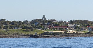
Robben Island is an island in Table Bay, 6.9 kilometres (4.3 mi) west of the coast of Bloubergstrand, north of Cape Town, South Africa. It takes its name from the Dutch word for seals (robben), hence the Dutch/Afrikaans name Robbeneiland, which translates to Seal(s) Island.

The Province of the Cape of Good Hope, commonly referred to as the Cape Province and colloquially as The Cape, was a province in the Union of South Africa and subsequently the Republic of South Africa. It encompassed the old Cape Colony, as well as Walvis Bay, and had Cape Town as its capital. In 1994, the Cape Province was divided into the new Eastern Cape, Northern Cape and Western Cape provinces, along with part of the North West.

The Western Cape is a province of South Africa, situated on the south-western coast of the country. It is the fourth largest of the nine provinces with an area of 129,449 square kilometres (49,981 sq mi), and the third most populous, with an estimated 7 million inhabitants in 2020. About two-thirds of these inhabitants live in the metropolitan area of Cape Town, which is also the provincial capital. The Western Cape was created in 1994 from part of the former Cape Province. The two largest cities are Cape Town and George.

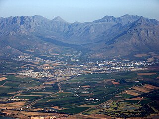
Paarl is a town with 112,045 inhabitants in the Western Cape province of South Africa. It is the third-oldest city and European settlement in the Republic of South Africa and the largest town in the Cape Winelands. Due to the growth of the Mbekweni township, it is now a de facto urban unit with Wellington. It is situated about 60 kilometres (37 mi) northeast of Cape Town in the Western Cape Province and is known for its scenic environment and viticulture and fruit-growing heritage.
Stellenbosch is a town in the Western Cape province of South Africa, situated about 50 kilometres east of Cape Town, along the banks of the Eerste River at the foot of the Stellenbosch Mountain. It is the second oldest settlement in the province, after Cape Town. The town became known as the City of Oaks or Eikestad in Afrikaans and Dutch due to the large number of oak trees that were planted by its founder, Simon van der Stel, to grace the streets and homesteads.

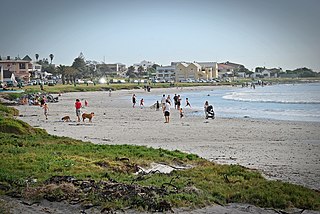
Struisbaai is a coastal settlement in the Overberg region of South Africa's Western Cape province. The town is in the Cape Agulhas Local Municipality in the Overberg District, about two hundred kilometres south east of Cape Town, and four kilometres from Cape Agulhas, which is the southernmost point of the African continent.

Lichtenburg is a town situated in North West Province of South Africa. It is the administrative centre of Ditsobotla Local Municipality.
Cape Agulhas Municipality is a municipality located in the Western Cape Province of South Africa. As of 2011 it had a population of 33,038. Its municipality code is WC033. It is named after Cape Agulhas, the southernmost point of Africa. The largest town is Bredasdorp, which is the seat of the municipal headquarters. It also includes the villages of Napier, Struisbaai, Elim, Arniston and L'Agulhas, and the De Hoop Nature Reserve.

Warrenton is an agricultural town of approximately 22,588 people in the Northern Cape province of South Africa, situated 70 kilometres (40 mi) north of Kimberley on the Vaal River.

The R63 is a tarred provincial route in South Africa that connects Calvinia with Komga via Carnarvon, Victoria West, Graaff-Reinet, Somerset East and King William's Town. It is cosigned with the N10 between Eastpoort and Cookhouse for 24 kilometres.

Gansbaai is a fishing town and popular tourist destination in the Overberg District Municipality, Western Cape, South Africa. It is known for its dense population of great white sharks and as a whale-watching location.

Port Elizabeth, officially renamed Gqeberha and colloquially often referred to as PE, is a major seaport city and the most populous city in the Eastern Cape province of South Africa. It is the seat of the Nelson Mandela Bay Metropolitan Municipality, South Africa's second-largest metropolitan district by area size. It is the sixth-most-populous city in South Africa and is the cultural, economic and financial centre of the Eastern Cape.

King William's Town is a town in the Eastern Cape province of South Africa along the banks of the Buffalo River. The city is about 60 kilometres (37 mi) northwest of the Indian Ocean port of East London. King William’s Town, with a population of around 100,000 inhabitants, forms part of the Buffalo City Metropolitan Municipality.

Khayelitsha is a township in Western Cape, South Africa, on the Cape Flats in the City of Cape Town. The name is Xhosa for New Home. It is reputed to be the largest and fastest-growing township in South Africa.

Wynberg is a southern suburb of the City of Cape Town in Western Cape, South Africa. It is situated between Plumstead and Kenilworth, and is a main transport hub for the Southern Suburbs of Cape Town.

The Castle of Good Hope known locally as the Castle or Cape Town Castle is a bastion fort built in the 17th century in Cape Town, South Africa. Originally located on the coastline of Table Bay, following land reclamation the fort is now located inland. In 1936 the Castle was declared a historical monument and following restorations in the 1980s it is considered the best preserved example of a Dutch East India Company fort.
Melkbosstrand is a coastal town located on the South West Coast of South Africa, 30 km north of Cape Town. It forms part of the City of Cape Town Metropolitan Municipality, the municipality governing Cape Town and its greater metropolitan area.

Rosebank is one of the Southern Suburbs of Cape Town, South Africa, located between the suburbs of Mowbray and Rondebosch.

Cookhouse is a small village located in Eastern Cape province, South Africa, some 170 kilometres (110 mi) north of Port Elizabeth and 24 kilometres (15 mi) east of Somerset East, on the west bank of the Great Fish River.

Murraysburg is an Afrikaans speaking town of approximately 5,000 people in the Western Cape province of South Africa. It is situated in the far northeast of the municipality, about 540 kilometres (340 mi) from the provincial capital Cape Town, and 80 kilometres (50 mi) west of Graaff-Reinet. It is governed as part of the Beaufort West Local Municipality within the Central Karoo District Municipality.


