The R351 is a Regional Route in South Africa. Its south-western origin is the R67 near Seymour. Its north-eastern origin is the R61 east of the N6 towards Cofimvaba.
Amatola, Amatole or Amathole are a range of densely forested mountains, situated in the Eastern Cape province of South Africa. The word Amatole means ‘calves’ in Xhosa, and Amathole District Municipality, which lies to the south, is named after these mountains.

The Lystrosaurus Assemblage Zone is a tetrapod assemblage zone or biozone which correlates to the upper Adelaide and lower Tarkastad Subgroups of the Beaufort Group, a fossiliferous and geologically important geological Group of the Karoo Supergroup in South Africa. This biozone has outcrops in the south central Eastern Cape and in the southern and northeastern Free State. The Lystrosaurus Assemblage Zone is one of eight biozones found in the Beaufort Group, and is considered to be Early Triassic in age.
The Great Winterberg is an extensive east-west mountain range lying immediately north of the small towns of Bedford, Adelaide and Fort Beaufort in the Eastern Cape of South Africa. Elevation on average is about 1800 metres above sea-level. The Great Winterberg Peak north of Adelaide rises to 2371 metres, high enough to be occasionally covered in snow. The underlying geology consists of shales and sandstones of the Beaufort Series of the Karoo System, frequently with dolerite intrusions. Rainfall on the southern slopes is fairly high. A notable pass over the range is the Katberg Pass built by Andrew Geddes Bain in 1860-64.
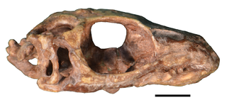
Paliguana is an extinct genus of lizard-like lepidosauromorph reptile from the Late Permian or Early Triassic Katberg Formation in the upper Lystrosaurus Assemblage Zone of South Africa.
Mpofu Nature Reserve is a nature reserve in the Amatole district of the Eastern Cape Province, South Africa that is managed by Eastern Cape Parks.
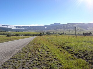
Katberg Pass is a mountain pass situated in the Eastern Cape province of South Africa, on the R351 between Seymour and Whittlesea. The pass climbs almost 700 meters in altitude to summit at 1622m ASL. The average gradient is 1:15 with some sections as steep as 1:3.

Dinanomodon is a genus of dicynodont from Late Permian (Changhsingian) of the Lystrosaurus Assemblage Zone, Katberg Formation, and Cistecephalus Assemblage Zone, Balfour Formation Beaufort Group, Karoo Basin of South Africa.
Phonodus is an extinct genus of procolophonid parareptile. It is known from a single skull found from the Early Triassic Katberg Formation in South Africa. It is the oldest known member of the subfamily Leptopleuroninae, and was likely the result of a procolophonid migration into the Karoo Basin from Laurasia after the Permo-Triassic extinction event. Because Phonodus had large maxillary teeth underneath a large antorbital buttress, and a lack of ventral temporal emargination along the side of the skull, it probably had a durophagous diet.
Coenyra aurantiaca, the Pondo shadefly, is a butterfly of the family Nymphalidae. It is found in South Africa, in the Eastern Cape from Alexandria to Wild Coast north to Umdoni Park in southern KwaZulu-Natal. Inland it is found to the Afromontane forests in the Amatolas and on the Katberg.
Kitchingnathus is an extinct genus of basal procolophonid parareptile from Early Triassic deposits of Eastern Cape Province, South Africa. It is known from the holotype BP/1/1187, skull and partial postcranium, which was first assigned to the more derived Procolophon trigoniceps. It was collected by the South African palaeontologist, James W. Kitching in October 1952 from Hobbs Hill, west of Cathcart. It was found in the middle or upper part of the Katberg Formation of the Beaufort Group and referred to the uppermost Lystrosaurus Assemblage Zone. It was first named by Juan Carlos Cisneros in 2008 and the type species is Kitchingnathus untabeni. The generic name honours James W. Kitching, and "gnathus", from Greek meaning mandible. The specific name meaning "from the hill", in isiZulu, in reference to the locality where the fossil was found.
Coletta is an extinct genus of basal procolophonid parareptile from Early Triassic deposits of Eastern Cape Province, South Africa. It is known from the holotype GHG 228, a skull with fragmentary lower jaws. It was collected on the farm Brakfontein 333 in the Cradock District. It was found in the Katberg Formation of the Beaufort Group and referred to the Lystrosaurus Assemblage Zone. It was first named by Christopher E. Gow in 2000 and the type species is Coletta seca.

Balfour is a town in Raymond Mhlaba Municipality, Amatole District Municipality, in the Eastern Cape province of South Africa.

The Kat River is a tributary of the Great Fish River, that drains the southern slopes of the Winterberg in the Eastern Cape Province, South Africa.

Eastern Province Command was a command of the South African Army.
Winterberg Commando was a light infantry regiment of the South African Army. It formed part of the South African Army Infantry Formation as well as the South African Territorial Reserve.

Katberg Commando was a light infantry regiment of the South African Army. It formed part of the South African Army Infantry Formation as well as the South African Territorial Reserve.

Midland Commando was a light infantry regiment of the South African Army. It formed part of the South African Army Infantry Formation as well as the South African Territorial Reserve.

The Katberg Formation is a geological formation that is found in the Beaufort Group, a major geological group that forms part of the greater Karoo Supergroup in South Africa. The Katberg Formation is the lowermost geological formation of the Tarkastad Subgroup which contains the Lower to Middle Triassic-aged rocks of the Beaufort Group. Outcrops and exposures of the Katberg Formation are found east of 24 degrees on wards and north of Graaff-Reniet, Nieu Bethesda, Cradock, Fort Beaufort, Queensdown, and East London in the south, and ranges as far north as Harrismith in deposits that form a ring around the Drakensberg mountain ranges.


