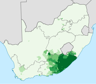
Xhosa, also isiXhosa, is a Nguni Bantu language with click consonants and is one of the official languages of South Africa and Zimbabwe. Xhosa is spoken as a first language by approximately 8.2 million people and by another 11 million as a second language in South Africa, mostly in Eastern Cape Province, Western Cape, Gauteng and Northern Cape. It has perhaps the heaviest functional load of click consonants in a Bantu language, with one count finding that 10% of basic vocabulary items contained a click.

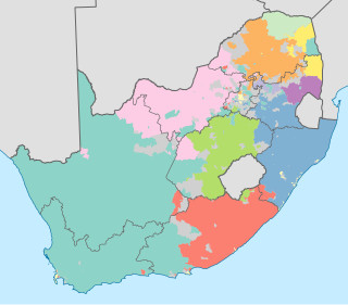
The Eastern Cape is one of the provinces of South Africa. Its capital is Bhisho, but its two largest cities are East London and Port Elizabeth.

The Northern Cape is the largest and most sparsely populated province of South Africa. It was created in 1994 when the Cape Province was split up. Its capital is Kimberley. It includes the Kalahari Gemsbok National Park, part of the Kgalagadi Transfrontier Park and an international park shared with Botswana. It also includes the Augrabies Falls and the diamond mining regions in Kimberley and Alexander Bay.
Orania is an Afrikaner town in South Africa located along the Orange River in the Karoo region of the Northern Cape province. The town is split in two halves by the R369 road and lies halfway between Cape Town and Pretoria.
At least thirty-five languages indigenous to South Africa are spoken in the Republic, ten of which are official languages of South Africa: Ndebele, Pedi, Sotho, Swati, Tsonga, Tswana, Venḓa, Xhosa, Zulu and Afrikaans. The eleventh official language is English, which is the primary language used in parliamentary and state discourse, though all official languages are equal in legal status, and unofficial languages are protected under the Constitution of South Africa, though few are mentioned by any name. South African Sign Language has legal recognition but is not an official language, despite a campaign and parliamentary recommendation for it to be declared one.
Bitou Local Municipality is a municipality part of Garden Route District Municipality located in the Western Cape Province of South Africa. Its municipality code is WC047.

Makhanda previously known as Grahamstown is a town of about 70,000 people in the Eastern Cape province of South Africa. It is situated about 110 kilometres (70 mi) northeast of Port Elizabeth and 130 kilometres (80 mi) southwest of East London. Makhanda is the largest town in the Makana Local Municipality, and the seat of the municipal council. It also hosts Rhodes University, the Eastern Cape Division of the High Court, The South African Library for the Blind (SALB) and a diocese of the Anglican Church of Southern Africa and 6 South African Infantry Battalion.

The Fengu people refers to a variety of ethnic groups that fled from the Mfecane to enter into various Xhosa speaking areas, but now often considered to have assimilated by the Xhosa people whose language they now speak. The term derives from the verb "ukumfenguza" which means to wander about seeking service. Historically they achieved considerable renown for their military ability in the frontier wars.
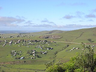
Sarah Baartman District Municipality is situated in the western part of the Eastern Cape province, covering an area of 58 242 square kilometres. The area of the district municipality includes seven local municipalities. The seat of Sarah Baartman is the city of Port Elizabeth, although Port Elizabeth is not itself in the district. The languages most spoken among the 388,201 people are Xhosa and Afrikaans.. The district code is DC10.

The Xhosa Wars were a series of nine wars or flare-ups between the Xhosa Kingdom and European settlers in what is now the Eastern Cape in South Africa. These events were the longest-running military action in the history of African colonialism.

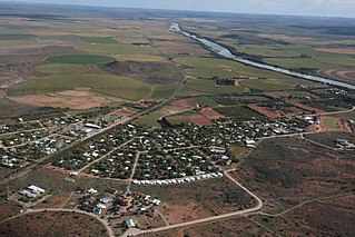
Butterworth is a town in the Eastern Cape Province, South Africa. Butterworth has a population of 45,900 and is situated on the N2 national highway 111 km north of East London.
Xhosa people are a Bantu ethnic group from Southern Africa whose homeland is primarily within the modern-day Eastern Cape. There is a small but significant Xhosa-speaking (Mfengu) community in Zimbabwe, and their language, isiXhosa, is recognised as a national language.
Thembelihle Local Municipality is a local municipality in the Pixley ka Seme District Municipality district of the Northern Cape province of South Africa. Thembelihle is a Xhosa name meaning "good hope".

Intsika Yethu Local Municipality is an administrative area in the Chris Hani District of the Eastern Cape in South Africa. The municipality is one of six in this district. Intsika Yethu is an isiXhosa name meaning "our pillars".

Coffee Bay is a town on the Wild Coast of the Eastern Cape Province of South Africa. It is located about 250 kilometres south of the city of Durban and has a population of 258 people.

Qumbu is a town in O.R.Tambo District Municipality in the Eastern Cape province of South Africa.

Peddie is a town in the Ngqushwa Local Municipality within the Amathole District Municipality in the Eastern Cape province of South Africa.
The AmaNdlambe are a tribe located in the Eastern Cape, South Africa; having been so named after its originator the great Xhosa prince Ndlambe, son of King Rharhabe. The AmaNdlambe are one of the last tribes to have been created in Xhosa history around the turn of the 19th century.

A transitional representative council is a local administrative division in South Africa. Between 1994 and 2000 it was the default type of municipal government. Every proclaimed village, town or city had its own transitional representative council. After apartheid it was created as a provisional local representation until the formation of a more final municipal structure. Due to the implementation of a municipal system in 2000, all - except one - transitional representative councils were abolished and their areas were merged into new municipalities.

The Orania Representative Council is the local municipal representative council in the Northern Cape province of South Africa that governs the Afrikaner-town of Orania in the Pixley ka Seme District Municipality. During the implementation of a new municipal system in South Africa in 2000, the Orania Representative Council was the only representative council that was not abolished. Therefore, the Orania Representative Council is the only municipal body that still uses the old (pre-2000) municipal structure, based on the Local Government Transition Act of 1993.


