Mount Bryce

Last updated
Mount Bryce
Mount Bryce (Canadian Rockies).JPG
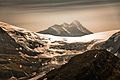
North face of Mt. Bryce seen from Columbia Icefield
Highest point
Elevation 3,507 m (11,506 ft) [1] [2]
Prominence 707 m (2,320 ft) [3]
Listing Mountains of British Columbia
Coordinates 52°02′28″N117°19′49″W / 52.041111°N 117.330278°W / 52.041111; -117.330278 [4]
Geography
Canada British Columbia relief location map.jpg
Red triangle with thick white border.svg
Mount Bryce
Country Canada
Province British Columbia
District Kootenay Land District [5]
Parent range Park Ranges
Topo map NTS 83C3 Columbia Icefield [4]
Climbing
First ascent 1902 by James Outram and Christian Kaufmann [1]
Easiest route rock/snow/glacier climb
Mount Bryce from Mount Wilcox Mount Bryce.jpg
Mount Bryce from Mount Wilcox

Mount Bryce is a mountain at the southwestern corner of the Columbia Icefield, in British Columbia, Canada, near the border with Alberta. It can be seen from the Icefields Parkway.

Contents

The mountain was named in 1898 by J. Norman Collie after Viscount James Bryce, who was President of the Alpine Club in London at the time. [1] [5]

Mount Bryce is the fifteenth-highest peak in British Columbia. [3] To the north, it is connected by ridges to the Columbia Icefield. The mountain is rarely climbed due to difficult access although recently built (test)logging roads are alleviating some of the access problems. [3]

See also

Related Research Articles

<span class="mw-page-title-main">Yoho National Park</span> National park in British Columbia, Canada

Yoho National Park is a national park of Canada. It is located within the Rocky Mountains along the western slope of the Continental Divide of the Americas in southeastern British Columbia, bordered by Kootenay National Park to the south and Banff National Park to the east in Alberta. The word Yoho is a Cree expression of amazement or awe, and it is an apt description for the park's spectacular landscape of massive ice fields and mountain peaks, which rank among the highest in the Canadian Rockies.

<span class="mw-page-title-main">Mount Columbia (Canada)</span> Highest mountain in Alberta, Canada

Mount Columbia is a mountain located in the Winston Churchill Range of the Rocky Mountains. It is the highest point in Alberta, Canada, and is second only to Mount Robson for height and topographical prominence in the Canadian Rockies. It is located on the border between Alberta and British Columbia on the northern edge of the Columbia Icefield. Its highest point, however, lies within Jasper National Park in Alberta.

<span class="mw-page-title-main">Mount Alberta</span> Mountain in Jasper NP, Alberta, Canada

Mount Alberta is a mountain located in the upper Athabasca River Valley of Jasper National Park, Alberta, Canada. J. Norman Collie named the mountain in 1898 after Princess Louise Caroline Alberta. It is the most difficult of the 11,000ers from a climbing point of view.

<span class="mw-page-title-main">Saint Elias Mountains</span> Mountain range in Canada and USA

The Saint Elias Mountains are a subgroup of the Pacific Coast Ranges, located in southeastern Alaska in the United States, Southwestern Yukon and the very far northwestern part of British Columbia in Canada. The range spans Wrangell-St. Elias National Park and Preserve in the United States and Kluane National Park and Reserve in Canada and includes all of Glacier Bay National Park in Alaska. In Alaska, the range includes parts of the city/borough of Yakutat and the Hoonah-Angoon and Valdez-Cordova census areas.

<span class="mw-page-title-main">Mount Hungabee</span> Mountain in Alberta and British Columbia, Canada

Mount Hungabee, officially Hungabee Mountain, is a mountain located on the boundaries of Banff National Park and Yoho National Park on the Continental Divide at the head of Paradise Valley, in Canada. The peak was named in 1894 by Samuel Allen after the Stoney Indian word for "chieftain" as the mountain is higher than its neighbouring peaks. The mountain can be seen from the Icefields Parkway (#93) in the upper Bow Valley.

<span class="mw-page-title-main">Columbia Icefield</span> Ice field in the Canadian Rockies

The Columbia Icefield is the largest ice field in North America's Rocky Mountains. Located within the Canadian Rocky Mountains astride the Continental Divide along the border of British Columbia and Alberta, Canada, the ice field lies partly in the northwestern tip of Banff National Park and partly in the southern end of Jasper National Park. It is about 325 square kilometres (125 sq mi) in area, 100 to 365 metres in depth and receives up to 7 metres (280 in) of snowfall per year.

<span class="mw-page-title-main">Waddington Range</span> Subrange of the Coast Mountains in southwestern British Columbia, Canada

The Waddington Range is a subrange of the Pacific Ranges of the Coast Mountains in southwestern British Columbia, Canada. It is only about 4,000 km2 in area, relatively small in area within the expanse of the range, but it is the highest area of the Pacific Ranges and of the Coast Mountains, being crowned by its namesake Mount Waddington 4,019 m (13,186 ft). The Waddington Range is also extremely rugged and more a complex of peaks than a single icefield, in contrast to the other huge icefield-massifs of the southern Coast Mountains, which are not so peak-studded and tend to have more contiguous icemasses.

<span class="mw-page-title-main">Mount Good Hope</span> Mountain in the country of Canada

Officially Good Hope Mountain but commonly known as Mount Good Hope is one of the principal summits of the Pacific Ranges of the southern Coast Mountains in British Columbia, Canada. It stands immediately west of Chilko Lake, with the highest peak on the massif rising between the lake's southern arms.

<span class="mw-page-title-main">Mount Hector (Alberta)</span> Mountain in Banff National Park, Alberta, Canada

Mount Hector is a 3,394-metre (11,135-foot) mountain summit located in the Bow River valley of Banff National Park, in the Canadian Rockies of Alberta, Canada. The mountain was named in 1884 by George M. Dawson after James Hector, a geologist on the Palliser expedition. The mountain is located beside the Icefields Parkway, 17 km (11 mi) north of Lake Louise.

<span class="mw-page-title-main">Mount Silverthrone</span>

Mount Silverthrone, officially named Silverthrone Mountain, is a mountain in the Pacific Ranges of the Coast Mountains of British Columbia, Canada, located over 320 km (200 mi) northwest of the city of Vancouver and about 50 km (30 mi) west of Mount Waddington, British Columbia, Canada. It is the highest peak in the Ha-Iltzuk Icefield, which is the largest icefield in the Coast Mountains south of the Alaska Panhandle.

Mount Callaghan is a volcanic peak located east of the headwaters of the Squamish River, just northeast of the Powder Mountain Icefield and just south of the Pemberton Icefield in the Sea to Sky Country of southwestern British Columbia, Canada, about 20 km directly west of the Resort Municipality of Whistler. A crack was observed across Callaghan's summit in the spring of 1999. In 2000, a section of the summit collapsed. Callaghan Lake lies below the south face of the mountain.

<span class="mw-page-title-main">Homathko Icefield</span> Icefield in British Columbia, Canada

The Homathko Icefield is an icefield in British Columbia, Canada. Officially named the Homathko Snowfield from 1950 until the current name was adopted in 1976, it is one of the largest icefields in the southern half of the Coast Mountains, with an area of over 2,000 km2 (770 sq mi). It is located between Chilko Lake and the Homathko River, and lies across the Great Canyon of that river to the east of the Waddington Range. Although adjacent to Mount Queen Bess, the Homathko Icefield is largely an expanse of ice, about 30 km (19 mi) across, ringed by relatively minor peaks and distinguished, relative to the other Coast Mountains icefields, by lack of any major ones. The Lillooet Icecap and the Compton Névé, both similar in size to the Homathko Icefield but much more peak-studded, lie to the Homathko Icefield's southeast across the Southgate River which bends around the icefield-massif's southern flank to reach the head of Bute Inlet adjacent to the mouth of the Homathko River. The icefield is essentially one large ice-girt montane plateau between these two rivers.

<span class="mw-page-title-main">Garibaldi Névé</span> Snowfield in British Columbia, Canada

The Garibaldi Névé is a snowfield in the Pacific Ranges of the Coast Mountains in southwestern British Columbia, Canada, located on the north and east sides of Mount Garibaldi in New Westminster Land District. The névé along with its outlet glaciers have a combined area of about 30 square kilometres.

Powder Mountain, 2,347 m (7,700 ft), is a volcanic summit in the Powder Mountain Icefield in the Pacific Ranges of the Coast Mountains in southwestern British Columbia, Canada.

<span class="mw-page-title-main">Mount Balfour</span> Mountain in Canadian Rockies

Mount Balfour is a mountain located on the Continental Divide, part of the border between British Columbia and Alberta, in the Waputik Range in the Park Ranges of the Canadian Rockies. It is the 71st highest peak in Alberta and the 113th highest in British Columbia; it is also the 52nd most prominent in Alberta.

<span class="mw-page-title-main">Park Ranges</span> Subrange of the Continental Ranges in Alberta and British Columbia, Canada

The Park Ranges, also known as the Main Ranges, are a group of mountain ranges in the Canadian Rockies of southeastern British Columbia and southwestern Alberta, Canada. It is one of the three main subranges and the most central of the Continental Ranges, extending from southeast of Mount McGregor to the Fernie Basin.

<span class="mw-page-title-main">Mount Pilkington</span> Mountain in the country of Canada

Mount Pilkington is located on the border of Alberta and British Columbia, between Mount Freshfield and Waitabit Peak. It was named in 1898 after Charles Pilkington. Mount Pilkington is located on the Continental Divide between the Campbell Icefield and the Freshfield Icefield.

<span class="mw-page-title-main">Castleguard Mountain</span> Mountain in Banff NP, Canada

Castleguard Mountain, also known as Mount Castleguard, is an isolated mountain located near the southern edge of the Columbia Icefield at the northern edge of Banff National Park in Alberta, Canada. In 1918, Irish land surveyor Arthur Oliver Wheeler named the mountain because of its castle-like appearance, which seemed to stand guard over the southern portion of the Columbia Icefield. Castleguard was first ascended in 1919 by the Interprovincial Boundary Commission, which determined the exact location of the boundary between British Columbia and Alberta along the continental divide.

The Andrei Icefield is a large icefield in the Boundary Ranges of the Coast Mountains in northwestern British Columbia, Canada. It is located 130 km (81 mi) northwest of the community of Stewart in Cassiar Land District. The icefield is the source of many valley glaciers, including Hoodoo Glacier and Twin Glacier, which lie at the headwaters of Hoodoo River and Twin River, respectively. Between these two glaciers is Hoodoo Mountain, a flat-topped stratovolcano of the Northern Cordilleran Volcanic Province. Other glaciers originating from the Andrei Icefield include Andrei Glacier, Porcupine Glacier, Johnson Glacier and Choquette Glacier, the latter of which lies at the headwaters of Choquette River.

<span class="mw-page-title-main">Otter Mountain</span>

Otter Mountain is a prominent 2,693-metre (8,835-foot) glaciated summit located in the Coast Mountains of British Columbia, Canada. It is situated 16 kilometers northeast of Stewart, British Columbia, and the nearest higher peak is Mount Pattullo, 25.4 km (15.8 mi) to the north. Otter ranks as the 23rd most topographically prominent summit of Canada. Topographic relief is significant as the summit rises 2,380 meters above Bitter Creek Valley in 5 kilometers. This mountain's toponym was adopted as "Mount Otter" on 24 July 1945, and officially renamed Otter Mountain on 5 November 1953 by the Geographical Names Board of Canada. Precipitation runoff from the mountain drains west into Bitter Creek which is a tributary of the Bear River, or east to Nelson Creek which is part of the Nass River drainage basin, and all ultimately finds its way to the Inside Passage.

References

  1. 1 2 3 "Mount Bryce". cdnrockiesdatabases.ca. Retrieved 2004-05-14.
  2. "Topographic map of Mount Bryce". opentopomap.org. Retrieved 2023-09-23.
  3. 1 2 3 "Mount Bryce". Bivouac.com. Retrieved 2007-01-17.
  4. 1 2 "Mount Bryce". Geographical Names Data Base . Natural Resources Canada . Retrieved 2023-09-23.
  5. 1 2 "Mount Bryce". BC Geographical Names . Retrieved 2009-05-22.