Mount Waddington, once known as Mystery Mountain, is the highest peak in the Coast Mountains of British Columbia, Canada. Although it is lower than Mount Fairweather and Mount Quincy Adams, which straddle the United States border between Alaska and British Columbia, Mount Waddington is the highest peak that lies entirely within British Columbia. It and the subrange which surround it, known as the Waddington Range, stand at the heart of the Pacific Ranges, a remote and extremely rugged set of mountains and river valleys.

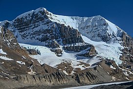
Mount Columbia is a mountain located in the Winston Churchill Range of the Rocky Mountains. It is the highest point in Alberta, Canada, and is second only to Mount Robson for height and topographical prominence in the Canadian Rockies. It is located on the border between Alberta and British Columbia on the northern edge of the Columbia Icefield. Its highest point, however, lies within Jasper National Park in Alberta.

Mount Alberta is a mountain located in the upper Athabasca River Valley of Jasper National Park, Alberta, Canada. J. Norman Collie named the mountain in 1898 after Princess Louise Caroline Alberta. It is the most difficult of the 11,000ers from a climbing point of view.

Mount Forbes is the seventh tallest mountain in the Canadian Rockies and the tallest within the boundaries of Banff National Park. It is located in southwestern Alberta, 18 km (11 mi) southwest of the Saskatchewan River Crossing in Banff. The mountain was named by James Hector in 1859 after Edward Forbes, Hector's natural history professor at the University of Edinburgh during the mid-19th century.

Mount Kitchener is a mountain located within the Columbia Icefield of Jasper National Park, which is part of the Canadian Rockies. The mountain can be seen from the Icefields Parkway near Sunwapta Pass.

Mount Temple is a mountain in Banff National Park of the Canadian Rockies of Alberta, Canada.

Mount Hungabee, officially Hungabee Mountain, is a mountain located on the boundaries of Banff National Park and Yoho National Park on the Continental Divide at the head of Paradise Valley, in Canada. The peak was named in 1894 by Samuel Allen after the Stoney Indian word for "chieftain" as the mountain is higher than its neighbouring peaks. The mountain can be seen from the Icefields Parkway (#93) in the upper Bow Valley.

The Columbia Icefield is the largest ice field in North America's Rocky Mountains. Located within the Canadian Rocky Mountains astride the Continental Divide along the border of British Columbia and Alberta, Canada, the ice field lies partly in the northwestern tip of Banff National Park and partly in the southern end of Jasper National Park. It is about 325 square kilometres (125 sq mi) in area, 100 to 365 metres in depth and receives up to 7 metres (280 in) of snowfall per year.

Mount Saskatchewan is a mountain located in the North Saskatchewan River valley of Banff National Park, in the Canadian Rockies of Alberta, Canada.
Barry Kenneth Blanchard is one of North America's top alpine climbers, noted for pushing the standards of highly technical, high-risk alpine climbing, ice climbing, and mixed climbing in the Canadian Rockies and the Himalayas.

Saint Nicholas Peak is a 2,938-metre (9,639-foot) mountain summit in the Rocky Mountains of Canada. It is located on the Continental Divide, on the Alberta-British Columbia border, in both Banff National Park and Yoho National Park. It lies at the eastern edge of the Wapta Icefield, and is part of the Waputik Mountains which are a sub-range of the Canadian Rockies.

Mt. Norquay is a mountain and ski resort in Banff National Park, Canada, that lies directly northwest of the Town of Banff. The regular ski season starts early December and ends mid-April. Mount Norquay is one of three major ski resorts located in the Banff National Park.

The Wapta Icefield is a series of glaciers located on the Continental Divide in the Waputik Mountains of the Canadian Rockies, in the provinces of British Columbia and Alberta, in Yoho National Park in the Canadian Rockies. The icefield is shared by Banff and Yoho National Parks and numerous outlet glaciers extend from the icefield, including the Vulture, Bow and Peyto Glaciers. Runoff from the icefields and outlet glaciers supply water to both the Kicking Horse and Bow Rivers, as well as numerous streams and lakes.
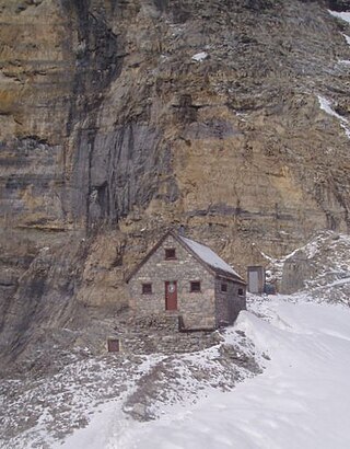
The Abbot Pass hut was an alpine hut located at an altitude of 2,925 metres (9,596 ft) in Abbot Pass in the Rocky Mountains in Alberta, Canada. It was nestled between Mount Victoria and Mount Lefroy, straddling the Great Divide, which, in this region, defines the boundary between Banff National Park in Alberta and Yoho National Park in British Columbia. While close to the border, the hut lay entirely in Banff National Park, and was the second-highest permanently habitable structure in Canada. The hut was maintained by the Alpine Club of Canada.

Mount Lyell is a mountain on the Alberta–British Columbia border in western Canada. Comprising five distinct summits, Mount Lyell reaches a height of 3,498 m (11,476 ft). The mountain was named by James Hector in 1858 in recognition of Scottish geologist Sir Charles Lyell.

Mount Balfour is a mountain located on the Continental Divide, part of the border between British Columbia and Alberta, in the Waputik Range in the Park Ranges of the Canadian Rockies. It is the 71st highest peak in Alberta and the 113th highest in British Columbia; it is also the 52nd most prominent in Alberta.

Mount Patterson is a peak in the Waputik Range of the Canadian Rockies. It is located within Banff National Park in Alberta of Western Canada. Mount Patterson stands across the Mistaya River Valley from Mount Weed, and both are prominent features seen from the Icefields Parkway. Its nearest higher peak is Howse Peak, 10.14 km (6.30 mi) to the northwest.
Castleguard Mountain, also known as Mount Castleguard, is an isolated mountain located near the southern edge of the Columbia Icefield at the northern edge of Banff National Park in Alberta, Canada. In 1918, Irish land surveyor Arthur Oliver Wheeler named the mountain because of its castle-like appearance, which seemed to stand guard over the southern portion of the Columbia Icefield. Castleguard was first ascended in 1919 by the Interprovincial Boundary Commission, which determined the exact location of the boundary between British Columbia and Alberta along the continental divide.

Hilda Peak is a 3,058-metre (10,033-foot) mountain summit located at the northern extreme of Banff National Park in the Canadian Rockies of Alberta, Canada. The nearest higher peak is Mount Athabasca, 2.0 km (1.2 mi) to the southwest. Hilda Peak is situated south of Sunwapta Pass and can be prominently seen from the Icefields Parkway. The Hilda Glacier lies to the south side of the peak, and the Boundary Glacier lies to the west.

Parker Ridge is a 2,255-metre (7,398-foot) mountain ridge located in the upper North Saskatchewan River valley in Banff National Park, in the Canadian Rockies of Alberta, Canada. Its nearest higher peak is Mount Athabasca, 7.7 km (4.8 mi) to the west. Parker Ridge is situated along the west side of the Icefields Parkway and southeast of Sunwapta Pass. Parker Ridge is a ski-touring destination in the winter and popular hiking destination in the summer because it is situated beside the Icefields Parkway allowing easy access, and is nearly entirely above treeline allowing good views of the surrounding mountain landscape. A 2.2 km (1.4 mi) trail gains 275 metres (900 ft) of elevation from the highway to the top of the ridge. Wandering east or west along the ridge provides views of Cirrus Mountain, the north face of Mount Saskatchewan, Saskatchewan Glacier, Mount Athabasca, Hilda Peak, and Nigel Peak among others.