
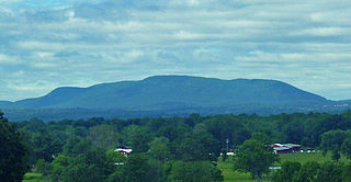
Surry County is a county located in the U.S. state of North Carolina. As of the 2020 Census, the population was 71,359. Its county seat is Dobson, and its largest city is Mount Airy.

Swatara Creek is a 72-mile-long (116 km) tributary of the Susquehanna River in east-central Pennsylvania in the United States. It rises in the Appalachian Mountains in central Schuylkill County and passes through northwest Lebanon County before draining into the Susquehanna at Middletown in Dauphin County.

The Santa Ana Mountains are a short peninsular mountain range along the coast of Southern California in the United States. They extend for approximately 61 miles (98 km) southeast of the Los Angeles Basin largely along the border between Orange and Riverside counties.

Henry W. Coe State Park is a state park of California, United States, preserving a vast tract of the Diablo Range. The park is located closest to the city of Morgan Hill, and is located in both Santa Clara and Stanislaus counties. The park contains over 87,000 acres (35,000 ha), making it the largest state park in northern California, and the second-largest in the state. Managed within its boundaries is a designated wilderness area of about 22,000 acres (8,900 ha). This is officially known as the Henry W. Coe State Wilderness, but locally as the Orestimba Wilderness. The 89,164-acre (36,083 ha) park was established in 1959.

Cloudland Canyon State Park is a 3,485 acres (14.10 km2) Georgia state park located near Trenton and Cooper Heights on the western edge of Lookout Mountain. One of the largest and most scenic parks in Georgia, it contains rugged geology, and offers visitors a range of vistas across the deep gorge cut through the mountain by Sitton Gulch Creek, where the elevation varies from 800 to over 1,800 feet. Views of the canyon can be seen from the picnic area parking lot, in addition to additional views located along the rim trail. At the bottom of the gorge, two waterfalls cascade across layers of sandstone and shale, ending in small pools below.

The Trough is a 6-mile long wooded gorge carved by the South Branch Potomac River (SBPR) and situated in the Allegheny Mountains of Hampshire and Hardy Counties, West Virginia, USA. The area was the site of a 1756 skirmish of the French and Indian War, known as the "Battle of the Trough".

Blue Knob State Park is a 6,128-acre (2,480 ha) Pennsylvania state park in Kimmel, Lincoln, and Pavia townships in Bedford County, Pennsylvania, in the United States. The average annual snowfall at the park is about 12 feet (370 cm). The park is named for Blue Knob, the second highest mountain in Pennsylvania at 3,146 feet (959 m). It is the location of Blue Knob All Seasons Resort, the ski slope in Pennsylvania with the highest elevation. Blue Knob State Park is just off Interstate 99 on Pennsylvania Route 869 west of Pavia.
Patterson Creek Mountain is a mountain ridge that forms the border between Mineral and Hampshire counties and Grant and Hardy Counties in West Virginia's Eastern Panhandle. The mountain's namesake, Patterson Creek, parallels its western flank. The southern end of the Patterson Creek Mountain is near the confluence of Lunice Creek and the South Branch Potomac River and its northern end is located southwest of Springfield. The mountain reaches its highest elevation at Charles Knob.

Black Mountain is a summit on Monte Bello Ridge in the Santa Cruz Mountains of west Santa Clara County, California, south of Los Altos and Los Altos Hills, and west of Cupertino; it is within the Palo Alto city limits though not near the developed part of the city. It is located on the border between Rancho San Antonio Open Space Preserve and Monte Bello Open Space Preserve, with the summit located in the former. Early Spanish explorers commonly named tree- or chaparral-covered summits which look black in the distance Loma Prieta, from the Spanish . The Spanish also called the middle portion of the Santa Cruz Mountains the Sierra Morena meaning, extending from Half Moon Bay Road south to a gap at Lexington Reservoir, and which includes a summit called Sierra Morena. There are over 100 "Black Mountains" in California.
Schunemunk Mountain is the highest mountain in Orange County, New York. The 1,664-foot (507 m) summit is located in the town of Blooming Grove, with other portions in Cornwall and Woodbury. The community of Mountain Lodge Park is built up its western slope.

Golden Ears Provincial Park is a Provincial park in British Columbia, Canada and is 555.9 square kilometres (214.6 sq mi). It is named after the prominent twin peaks which are commonly referred to as Golden Ears. The park's southern end is located on the northern edge of the district municipality of Maple Ridge on the north side of the Fraser River.
Powell Mountain is a mountain ridge of the Ridge-and-valley Appalachians of the Appalachian Mountains. It is a long and narrow ridge, running northeast to southwest, from about Norton, Virginia to near Tazewell, Tennessee. It separates the Clinch River basin and the Powell River basin of Powell Valley. It was named for an 18th-century explorer.

Penns Valley is an eroded anticlinal valley of the Pennsylvania ridge and valley geologic region of the Appalachian Mountain range. The valley is located in southern Centre County, Pennsylvania. Along with the Nittany Valley to the north and east, it is part of the larger Nittany Anticlinorium. It is bordered by Nittany Mountain to the north, the Seven Mountains range to the south, and connects to the larger Nittany Valley to the west. There are two smaller subordinate valleys typically associated with the greater valley: Georges Valley in the south, separated by Egg Hill, and Brush Valley in the north, separated by Brush Mountain.

Sugarloaf Ridge State Park is a state park in Northern California, United States. Located in the Mayacamas Mountains north of Kenwood, the park straddles the boundary between Sonoma and Napa counties. The park contains the 2,729-foot (832 m) Bald Mountain and the headwaters of Sonoma Creek including a 25-foot (8 m) tall seasonal waterfall. The park is also home to the volunteer-run Robert Ferguson Observatory. Camping, picnicking, horseback riding, mountain biking, stargazing, fishing and hiking are common attractions of Sugarloaf. The park boasts 25 miles of trails with trails ranging from less than a mile to 8.8 miles, and elevation gains reaching 2,500 feet.

Monte Bello Open Space Preserve is a 3,133-acre (12.68 km2) open space preserve, located near Palo Alto in the Santa Cruz Mountains, in San Mateo and Santa Clara Counties, California, United States. The preserve encompasses the upper Stevens Creek watershed in the valley between Monte Bello Ridge and Skyline Ridge. "Monte Bello" means "beautiful mountain" in Italian, and refers to Black Mountain which is the highest part of Montebello Ridge. The straight valley of upper Stevens Creek is also the rift valley of the San Andreas Fault.

The Thunderer el. 10,558 feet (3,218 m) is a mountain peak in the northeast section of Yellowstone National Park, in the Absaroka Range of the U.S. state of Wyoming. Named by members of the Arnold Hague Geological Survey of 1885 for its propensity to attract thunderstorms, the mountain is a long high ridge just north of Mount Norris. Prior to 1885, the peak was merely considered a high ridge extending north from Mount Norris rather than a separately named peak. The Thunderer is easily visible from the northeast entrance road as it passes up the Soda Butte Creek canyon.
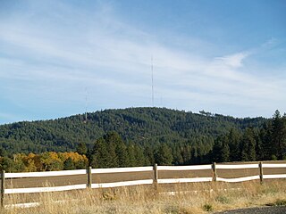
Krell Hill, also known as Tower Mountain, is a peak at the southern end of the Selkirk Mountains in Spokane County, Washington. It rises abruptly to the southeast of the relatively flat South Hill area of the city of Spokane. An area of high topographical relief continues to the east of the mountain towards Mica Peak and the Coeur d'Alene Mountains of the Bitterroot Range, in turn part of the Rocky Mountains. To the north the mountain descends slowly along a ridge into the Dishman Hills and eventually the Spokane Valley. To the south and west the mountain towers over relatively flat terrain, with the vast farmland of the Palouse and the Columbia Plateau extending as far as the eye can see.

Pisgah Mountain or Pisgah Ridge is a ridgeline running 12.5 miles (20.1 km) from Tamaqua to Jim Thorpe, Pennsylvania. It is oriented north-northeast to south-southwest, and its north-side valley is followed by U.S. Route 209 from river gap to river gap. The ridge is a succession of peaks exceeding 1,440 feet (438.9 m) rising 300 to 540 feet above the boroughs of Lansford, Coaldale, and Tamaqua in the Panther Creek valley. The highest point on Pisgah Mountain is at 1,611 feet (491 m) in the borough of Summit Hill, which sits atop the ridge. Near Summit Hill was the "Sharpe Mountain" (peak) where in 1791 Phillip Ginter is documented as having discovered anthracite, leading to the formation of the Lehigh Coal Mine Company. In 1818 the Lehigh Coal Company took over the mines, and the mining camp gradually became a settlement and grew into Summit Hill.
Nesquehoning Mountain or Nesquehoning Ridge is a 15–17-mile-long (24–27 km) coal bearing ridge dividing the waters of Lehigh Valley to the north from the Schuylkill River valley and the several near parallel ridgelines of the Ridge-and-valley Appalachians barrier range all local members of which run generally WSW-ENE in the greater overall area.
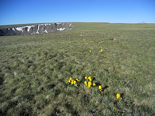
Calf Creek Plateau is a mountain in the northern San Juan Mountains of the Rocky Mountains of North America. The mountain is located in Hinsdale County, and at an elevation of 12,661 feet (3,859 m), it is the high point of the Powderhorn Wilderness.

