
Bragg Creek is a hamlet in southern Alberta under the jurisdiction of Rocky View County in Division No. 6.

Kananaskis Country is a multi-use recreation area situated to the west of Calgary, Alberta, Canada, in the foothills and front ranges of the Canadian Rockies. The area is named for the Kananaskis River, which was named by John Palliser in 1858 after a Cree acquaintance.

Willmore Wilderness Park, located in Alberta, Canada, is a 4,600-square-kilometre (1,800 sq mi) wilderness area adjacent to Jasper National Park. It is lesser known and less visited than Jasper National Park. There are no public roads, bridges or buildings. There are, however, several ranger cabins in the park that are available as a courtesy to visitors.

The Peace River is a 1,923-kilometre-long (1,195 mi) river in Canada that originates in the Rocky Mountains of northern British Columbia and flows to the northeast through northern Alberta. The Peace River joins the Athabasca River in the Peace-Athabasca Delta to form the Slave River, a tributary of the Mackenzie River. The Finlay River, the main headwater of the Peace River, is regarded as the ultimate source of the Mackenzie River. The combined Finlay–Peace–Slave–Mackenzie river system is the 13th longest river system in the world.

Fish Creek Park is an urban provincial park that preserves the valley of Fish Creek in the southern part of Calgary, Alberta, Canada. It is bordered on three sides by the city, and on the west by the territory of the Tsuu T’ina Nation (Sarcee), a First Nation.

Foothills-Rocky View was a provincial electoral district in Alberta, Canada, mandated to return a single member to the Legislative Assembly of Alberta from under the First Past the Post voting system 2004 to 2012.

The Elbow River is a river in southern Alberta, Canada. It flows from the Canadian Rockies to the city of Calgary, where it merges into the Bow River.

Rocky View County is a municipal district in southern Alberta, Canada that is named for its views of the nearby Rocky Mountains to the west. It surrounds most of Calgary, forming the city's northern boundary and most of the city's western and eastern boundaries. At a population of 39,407 in 2016, Rocky View County is the most populous municipal district in Alberta. Though predominantly rural in nature, Rocky View County is home to 14 hamlets, including Langdon, one of Alberta's most populous hamlets. Its rural areas are home to numerous country residential subdivisions.
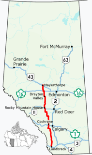
Alberta Provincial Highway No. 22, commonly referred to as Highway 22 and officially named Cowboy Trail, is a 584-kilometre (363 mi) highway in the Canadian province of Alberta. It generally parallels Highway 2, beginning in the foothills of southern Alberta at Highway 3 near Lundbreck Falls. It proceeds north along the eastern slopes of the Rocky Mountains passing through the foothills and ranch country to the aspen parkland of northern Alberta, ending at Highway 18 near Mayerthorpe.
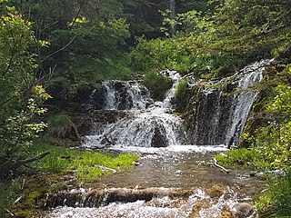
Big Hill Springs Provincial Park is a provincial park in the foothills of Alberta's Rocky Mountains, about 40 kilometres (20 mi) northwest of Calgary, Alberta, Canada. It features a series of springs and small waterfalls that flow year-round over rocky terraces covered with a lush growth of mosses, shrubs, and grasses. The park also includes the ruins of an historic fish hatchery and Alberta's first commercial creamery. The main activities at the park are hiking, picnicking, scenic viewing, wildlife watching, and photography.
Peter Lougheed Provincial Park is a provincial park located in Alberta, Canada. The park is in Kananaskis Country about 90 kilometres (56 mi) west of Calgary, along the Kananaskis Trail.

William A. Switzer Provincial Park is a provincial park in Alberta, Canada.

Hamber Provincial Park is a provincial park in British Columbia, Canada, located at the provincial boundary with Alberta, surrounded on three sides by Jasper National Park. When the park was created in 1941, it constituted one of the largest protected wilderness areas in Canada. In the early 1960s, the provincial government reduced its size by 98% due to pressure exerted by the forestry industry, planned hydroelectric developments along the upper Columbia River and the re-routing of the Trans-Canada Highway away from the park.

Mount Assiniboine Provincial Park is a provincial park in British Columbia, Canada, located around Mount Assiniboine.

The Canadian city of Calgary, Alberta, is home to a relatively deep-seated tradition of winter sports. Much of this stems from its location, with proximity to the Alberta Rocky Mountains and Banff National Park. After hosting the 1988 Winter Olympics, the city has also had winter sports and training facilities. Beyond winter sports, Calgary has a number of professional and amateur sports teams and is a major world pro rodeo centre; with the city's Stampede Park holding the annual Calgary Stampede.

Sheep River Provincial Park is a provincial park located in Alberta, Canada, 23 kilometres (14 mi) west of Turner Valley on highway 546. It is part of the Kananaskis Country park system and encompasses a portion of the Sheep River valley.

The Wapiti River is a river in eastern British Columbia and western Alberta, Canada. It is a major tributary of the Smoky River, located in the southern area of the Peace River Basin.
The Ghost River Wilderness Area is a provincially designated wilderness area in the Canadian Rockies of Alberta protecting the headwaters of the Ghost River. It was established in 1967 and it, as one of the three Wilderness Areas of Alberta, has the strictest form of government protection available in Canada. All development is forbidden and only travel by foot is permitted. Hunting and fishing are not allowed. The other two Wilderness Areas are White Goat Wilderness Area and Siffleur Wilderness Area and together the three areas total 249,548.80 acres (100,988.82 ha).

The White Goat Wilderness Area is a provincially designated wilderness area in the Canadian Rockies of Alberta. It was established in 1961 and it, as one of the three wilderness areas of Alberta, has the strictest form of government protection available in Canada. All development is forbidden and only travel by foot is permitted. Hunting and fishing are not allowed. The other two wilderness areas are Ghost River Wilderness Area and Siffleur Wilderness Area and together the three areas total 249,548.80 acres (100,988.82 ha).

The Siffleur Wilderness Area is a provincially designated wilderness area in the Canadian Rockies of Alberta. It was established in 1961 and it, as one of the three wilderness areas of Alberta, has the strictest form of government protection available in Canada. All development is forbidden and only travel by foot is permitted. Hunting and fishing are not allowed. The other two wilderness areas are White Goat Wilderness Area and Ghost River Wilderness Area and together the three areas total 249,548.80 acres (100,988.82 ha).


