
Alberta is one of the thirteen provinces and territories of Canada. It is part of Western Canada and is one of the three prairie provinces. Alberta is bordered by British Columbia to the west, Saskatchewan to the east, the Northwest Territories (NWT) to the north, and the U.S. state of Montana to the south. It is one of the only two landlocked provinces in Canada. The eastern part of the province is occupied by the Great Plains, while the western part borders the Rocky Mountains. The province has a predominantly continental climate but experiences quick temperature changes due to air aridity. Seasonal temperature swings are less pronounced in western Alberta due to occasional Chinook winds.

Sherwood Park is a large hamlet in Alberta, Canada within Strathcona County that is recognized as an urban service area. It is located adjacent to the City of Edmonton's eastern boundary, generally south of Highway 16, west of Highway 21 and north of Highway 630. Other portions of Sherwood Park extend beyond Yellowhead Trail and Wye Road, while Anthony Henday Drive (Highway 216) separates Refinery Row to the west from the balance of the hamlet to the east.

The Cypress Hills are a geographical region of hills in southwestern Saskatchewan and southeastern Alberta, Canada. The hills are part of the Missouri Coteau upland.

The Municipality of Crowsnest Pass is a specialized municipality in southwest Alberta, Canada. Within the Rocky Mountains adjacent to the eponymous Crowsnest Pass, the municipality formed as a result of the 1979 amalgamation of five municipalities – the Village of Bellevue, the Town of Blairmore, the Town of Coleman, the Village of Frank, and Improvement District No. 5, which included the Hamlet of Hillcrest and numerous other unincorporated communities.

Calgary-North Hill was a provincial electoral district in Calgary, Alberta, Canada, mandated to return a single member to the Legislative Assembly of Alberta using the first past the post method of voting from 1971 to 2012.

Calgary-Foothills is a provincial electoral district for the Legislative Assembly of Alberta, Canada. It is located in the northwest corner of Calgary. It elected six consecutive Progressive Conservative MLAs from its creation in 1971 until ousted Premier Jim Prentice disclaimed his winning seat on the 2015 general election night, later electing a member of the Wildrose in the following by-election.
Cypress Hills Interprovincial Park is a natural park in Canada straddling the Alberta / Saskatchewan boundary and jointly administered by the two provinces. Located south-east of Medicine Hat, it became Canada's first interprovincial park in 1989.
Alberta Provincial Highway No. 1, commonly referred to as Highway 1, is a major east–west highway in Southern Alberta that forms the southern mainline of the Trans-Canada Highway. It runs from the British Columbia border near Lake Louise through Calgary to the Saskatchewan border east of Medicine Hat. It continues as Highway 1 into both provinces. It spans approximately 534 km (332 mi) from Alberta's border with British Columbia in the west to its border with Saskatchewan in the east. The route is a divided 4-lane expressway throughout the province with the exception of a section in central Calgary where it is an arterial thoroughfare and Urban Boulevard carrying 4 to 6 lanes. The highway is a freeway between the Sunshine exit near the town of Banff and Home Road in Calgary. Other rural sections have at grade intersections with Interchanges only at busier junctions. Twinning of the final 8.5 km (5.3 mi) of Highway 1 between Lake Louise and the British Columbia border was completed by Parks Canada and opened to traffic on June 12, 2014 making the whole length of Alberta Highway 1 a divided minimum 4-lane route.
Redwater is a town in the Edmonton Metropolitan Region of Alberta, Canada that is surrounded by Sturgeon County. It is located on Highway 38, approximately 52 km (32 mi) north of Edmonton. Its population was 2,053 in the 2016 census, while the town's municipal census conducted in 2012 counted a population of 2,116.

Alberta Provincial Highway No. 21, commonly referred to as Highway 21, is a north-south highway in Alberta, Canada that parallels Highway 2 between Calgary and Edmonton. It is approximately 328 kilometres (204 mi) in length. It begins at the Trans-Canada Highway (Highway 1) east of Strathmore, and ends at Fort Saskatchewan where it is succeeded by Highway 15. The northernmost 25 kilometres (16 mi) of the highway are twinned. Highway 21 runs roughly parallel to the main north-south CN rail line between Calgary and Edmonton between Three Hills and Looma.

Alberta Provincial Highway No. 58, commonly referred to as Highway 58, is an east–west highway in northwest Alberta, Canada. It starts west of the Rainbow Lake Airport and passes through the towns of Rainbow Lake and High Level before it ends at the Wood Buffalo National Park boundary west of Garden River.

Alberta has been a tourist destination since the early days of the 20th Century, with attractions including national parks, National Historic Sites of Canada, urban arts and cultural facilities, outdoor locales for skiing, hiking and camping, shopping locales such as West Edmonton Mall, outdoor festivals, professional athletic events, international sporting competitions such as the Commonwealth Games and Olympic Winter Games, as well as more eclectic attractions.

Greene Valley Provincial Park is a provincial park east of the Town of Peace River, Alberta, Canada, in Northern Sunrise County. It was designated a provincial park on June 6, 2000, by the Alberta provincial government.

Mackenzie County is a specialized municipality in northern Alberta, Canada. It is located in Census Division 17, along the Mackenzie Highway. Mackenzie County municipal office is located in the Hamlet of Fort Vermilion.
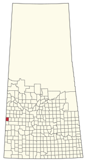
The Rural Municipality of Antelope Park No. 322 is a rural municipality (RM) in the Canadian province of Saskatchewan within Census Division No. 13 and SARM Division No. 6. It is located along the border with Alberta.
The Ministry of Environment and Protected Areas of Alberta is the Alberta provincial ministry of the Executive Council of Alberta responsible for environmental issues and policy as well as parks and protected areas in Alberta.

