Cypress Hills Interprovincial Park

Last updated

Cypress Hills Interprovincial Park
CypressHills1.JPG
Cypress Hills
Canada relief map 2.svg
Red pog.svg
Location of Cypress Hills Interprovincial Park in Canada
Location, Canada
Nearest city Medicine Hat, AB; Swift Current, SK
Coordinates 49°34′31″N110°00′23″W / 49.57528°N 110.00639°W / 49.57528; -110.00639
Area400 km2 (150 sq mi)
Established1931 (Saskatchewan)
1951 (Alberta)
1989 (interprovincial)
Governing body Alberta Environment and Parks and Ministry of Parks, Culture and Sport (Saskatchewan)

Cypress Hills Interprovincial Park is a natural park in Canada straddling the Alberta / Saskatchewan boundary and jointly administered by the two provinces. Located south-east of Medicine Hat in the Cypress Hills, it became Canada's first interprovincial park in 1989. [1]

Contents

The park consists of two protected areas, the 345 km2 (133 sq mi) West Block, that straddles the Alberta / Saskatchewan boundary between Alberta Highway 41, the townsite of Elkwater, Saskatchewan Highway 615, Saskatchewan Highway 271, and Fort Walsh, and the Centre Block, an additional area of 58 km2 (22 sq mi) in Saskatchewan, west of Saskatchewan Highway 21.

Geography

The Cypress Hills plateau rises up to 200 m (660 ft) above the surrounding prairie, to a maximum elevation of 1,468 m (4,816 ft) at "Head of the Mountain" at the west end in Alberta, [2] making it Canada's highest point between the Canadian Rockies and the Labrador Peninsula. [3] Eastward across the boundary is the highest point in Saskatchewan, at 1,392 m (4,567 ft). [4] The "West Block" of the Cypress Hills spans the provincial boundary. Battle Creek runs through the central part of the park. Although the hills seem relatively low, in a larger geographic context the plateau does rise gradually from many kilometres away so that the total elevation gain from Medicine Hat is approximately 600 metres (2,000 ft).

History

Activities

On both sides of the park, all year long, park interpreters present education programs to school and youth groups, adult and seniors groups, and a wide range of park visitors. During the summer months, there's camping, hiking, and swimming. During the winter, there's skiing, winter camping, snowmobiling, and other winter activities. In summertime, kayak, canoe, bicycle, and stand up paddle boards are available for rent. In the winter, kicksleds, snowshoes, skates, and cross-country skis rentals are available.

Alberta

On the Alberta side of West Block, key park features include Head of the Mountain Viewpoint, the highest point between the Rocky Mountains and Labrador, the Elkwater townsite (a cottage community sitting at the same elevation as the Banff townsite), Horseshoe Canyon and Reesor Lake viewpoints (offering 100-kilometre (62 mi) views on a clear day), over 50 kilometres (31 mi) of hiking and mountain biking trails, and Hidden Valley Ski Resort. [10] [11] Three lakes sit on the Alberta side of the park — Elkwater Lake, Spruce Coulee Reservoir, and Reesor Lake.

Saskatchewan

Loch Leven LochLeven-msu-2020-1110-9089.jpg
Loch Leven

Like in Alberta, there are campgrounds, hiking trails, and lakes. Some of the lakes include Harris, Adams, Coulee Lake, Loch Lomond, and Loch Leven. On the shores of Loch Leven in Centre Block is a marina, [12] the community of Loch Leven, a restaurant, swimming pool, tourist info centre, and The Resort at Cypress Hills. [13]

Winter amenities around the park include a winter picnic shelter, warm-up shacks, a tobogganing hill, a mini-luge slide, and Camp-Easy yurt rentals. [14] [15] There are also snowmobile and winter fat bike trails. [16]

Cypress Hills Ski Area

Cypress Hills Ski Area is a cross-country ski area on the Saskatchewan side of Cypress Hills Interprovincial Park. During the winter, summer campgrounds are transformed into 9 kilometres (5.6 mi) of Cross-country skiing trails and 3.8 kilometres (2.4 mi) of snowshoeing trails. [17] A further 27 kilometres (17 mi) of summer hiking trails are designated for cross-country skiing, 15 kilometres (9.3 mi) of which are groomed. [18]

Nature

A panorama of Cypress Hills A panorama of Cypress Hills.jpg
A panorama of Cypress Hills

Approximately 700 species of plants and animals thrive in the park, including 14 species of orchids.

The park protects the majority of the Cypress Hills landscape, which consists of three separate elevated blocks of lush forest and fescue grassland surrounded by dry mixed-grass prairie. The West and Centre Blocks are protected as provincial parks, and are managed by Alberta Parks and Protected Areas [19] and Saskatchewan Parks, [20] respectively. The "East Block" of the Cypress Hills, situated near Eastend, Saskatchewan, is not a park or protected area. The Fort Walsh National Historic Site is also located adjacent to the West Block.

Mammals

There are five species of large hoofed mammals found in the park: [21] wapiti, moose, mule deer, white-tailed deer, and pronghorn. Other mammals found in Cypress Hills Interprovincial Park include: [21]

Eulipotyphla

Lagomorpha

Chiroptera

Carnivora

Rodentia

Fish species

Fish species include walleye, yellow perch, northern pike, brook, brown, westslope cutthroat and rainbow trout, burbot, common carp, white sucker, and shorthead redhorse.

See also

Related Research Articles

<span class="mw-page-title-main">Tourism in Canada</span> Overview of tourism in Canada

Canada has a large domestic and foreign tourism industry. The second largest country in the world, Canada's wide geographical variety is a significant tourist attractor. Much of the country's tourism is centred in the following regions: Toronto, Montreal, Quebec City, Vancouver/Whistler, Niagara Falls, Vancouver Island, Canadian Rockies, British Columbia's Okanagan Valley, Churchill, Manitoba and the National Capital Region of Ottawa-Gatineau. The large cities are known for their culture, diversity, as well as the many national parks and historic sites.

<span class="mw-page-title-main">Cypress Hills (Canada)</span> Hills in Alberta and Saskatchewan, Canada

The Cypress Hills are a geographical region of hills in southwestern Saskatchewan and southeastern Alberta, Canada. The hills are part of the Missouri Coteau upland.

<span class="mw-page-title-main">Willmore Wilderness Park</span> Provincial park of Alberta, Canada

Willmore Wilderness Park, in Alberta, Canada, is a 4,600-square-kilometre (1,800 sq mi) wilderness area adjacent to Jasper National Park. It is lesser known and less visited than Jasper National Park. There are no public roads, bridges or buildings. There are, however, several ranger cabins in the park that are available as a courtesy to visitors.

Elkwater is an unincorporated community at the western edge of the Cypress Hills in southeastern Alberta, Canada, 65 kilometres (40 mi) southeast of Medicine Hat. The main access route is via Alberta Highway 41, which leads south from the Trans-Canada Highway.

<span class="mw-page-title-main">Maple Creek, Saskatchewan</span> Town in Saskatchewan, Canada

Maple Creek is a town in the Cypress Hills of southwest Saskatchewan, Canada. It is surrounded by the Rural Municipality of Maple Creek No. 111. The population was 2,176 at the 2021 Census.

<span class="mw-page-title-main">Cypress County</span> Municipal district in Alberta, Canada

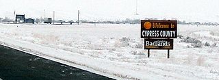
Cypress County is a municipal district in southeastern Alberta, Canada that surrounds the City of Medicine Hat and the Town of Redcliff. The municipality is part of Census Division 1, Alberta. The first farm in the area was settled in 1890.

<span class="mw-page-title-main">Elkwater Lake (Alberta)</span> Lake in Alberta

Elkwater Lake is a small lake located in the northwest corner of the Cypress Hills Interprovincial Park in southeastern Alberta, Canada. It is reached via Alberta Highway 41, and the tourist community of Elkwater lies on its southern shore. Its name is a translation of Ponokiokwe, the Blackfoot name for the lake.

<span class="mw-page-title-main">Southern Alberta</span> Region of Alberta, Canada (est. 1905)

Southern Alberta is a region located in the Canadian province of Alberta. In 2016, the region's population was approximately 291,112. The primary cities are Lethbridge and Medicine Hat. The region is known mostly for agricultural production, but other sectors, such as alternative energy, film production and tourism, are emerging.

Highway 221 is a provincial highway in the Canadian province of Saskatchewan. Saskatchewan's 200-series highways primarily service its recreational areas. The highway runs from Highway 21 to the Centre Block of Cypress Hills Interprovincial Park. It is about 4 kilometres (2.5 mi) long.

Highway 55 is a paved, undivided provincial highway in the Canadian province of Saskatchewan. It runs from the Alberta border west of Pierceland to Highway 9 near Mountain Cabin. Highway 55 is about 652 kilometres (405 mi) long and forms part of the interprovincial Northern Woods and Water Route.

Carmichael is a special service area within the Rural Municipality of Carmichael No. 109, Saskatchewan, Canada that held village status prior to 2019. The population was 58 at the 2016 Census. Carmichael lies 1 km (1 mi) south of Highway 1 commonly known as the Trans Canada Highway, approximately 158 km (98 mi) east of city of Medicine Hat, Alberta.

<span class="mw-page-title-main">Meadow Lake Provincial Park</span> Provincial park in Saskatchewan, Canada

Meadow Lake Provincial Park is a northern boreal forest provincial recreational park along the Waterhen and Cold Rivers in the Canadian province of Saskatchewan. The park was founded on 10 March 1959, is the largest provincial park in Saskatchewan, and encompasses over 25 lakes in an area of 1,600 km2 (620 sq mi). The park was named "Meadow Lake" after the city of Meadow Lake and Meadow Lake. The city and the lake are not in the park and are located about 40 kilometres (25 mi) south-east of the nearest park entrance, which is about 5 kilometres (3.1 mi) north of Dorintosh. The length of the park stretches about 113 kilometres (70 mi) from Cold Lake on the Saskatchewan / Alberta border in the west to the eastern shore of Waterhen Lake in the east.

Greenwater Lake Provincial Park is a provincial park in the Canadian province of Saskatchewan. It is located on the eastern side of the province in the Porcupine Hills on Highway 38. The closest town, Porcupine Plain, is about 28 kilometres (17 mi) to the north-east of the park visitor centre. Founded on 19 February 1932, Greenwater is one of the oldest provincial parks in Saskatchewan. The original six parks were established in 1931 and Greenwater Provincial Park was added one year later. In 1964, the park was expanded to its current size.

Duck Mountain Ski Area is a ski area located in Saskatchewan's Duck Mountain Provincial Park approximately 2.5 kilometres (1.6 mi) from the Manitoba / Saskatchewan border. It is 36 kilometres (22 mi) from Kamsack and 116 kilometres (72 mi) from Yorkton. The Duck Mountains, the area where the hill is located, are a feature of the Manitoba Escarpment. Thunderhill Ski Area, 50 kilometres (31 mi) to the north is another ski hill located along the Manitoba Escarpment. The operating season for Duck Mountain Ski Area varies depending on weather and snow conditions, but the hill typically is open from late December to mid-March every year.

<span class="mw-page-title-main">Good Spirit Lake Provincial Park</span> Provincial park in Saskatchewan, Canada

Good Spirit Lake Provincial Park is a provincial park on the eastern side of the Canadian province of Saskatchewan. Founded in 1931, the park surrounds the western and southern shores of Good Spirit Lake and is one of Saskatchewan's six founding provincial parks. The park is in the RM of Good Lake No. 274, about 48 kilometres (30 mi) north of the city of Yorkton. Highway 47 runs along the western boundary and Highway 229 provides access to the park's amenities.

The Battlefords Provincial Park is a recreational provincial park in the Canadian Province of Saskatchewan. It is about 39 kilometres (24 mi) north of the city of North Battleford in the RM of Meota No. 468 on Jackfish Lake. Highway 4 runs north from North Battleford to the park and Highway 204 runs through the park providing access to the amenities.

Douglas Provincial Park is a provincial park in the Canadian province of Saskatchewan. Established in 1973, it is named after Tommy Douglas, the seventh premier of Saskatchewan and father of Canada's first single-payer, universal health care programme. The park is located along the Gordon McKenzie Arm of Lake Diefenbaker and at the Qu'Appelle River Dam, which is the source of the Qu'Appelle River. The closest community is Elbow and access to the park is from Highway 19.

Great Blue Heron Provincial Park is a recreational park in the central region of the Canadian province of Saskatchewan in the boreal forest ecozone of Canada. It is adjacent to the eastern boundary of Prince Albert National Park, about 50 kilometres (31 mi) north of the city of Prince Albert. The provincial park was established in 2013 from two pre-existing provincial recreation sites – Emma Lake and Anglin Lake Recreation Sites – and the addition of a large tract of Crown land.

White Butte Trails Recreation Site is a cross-country ski area in the RM of Edenwold No. 158 in the Canadian province of Saskatchewan. The name "White Butte" is an amalgamation of the nearby communities of White City and Pilot Butte. The park is about 4 kilometres (2.5 mi) north of White City and 20 minutes east of Regina in a region referred to as White Butte. The ski area consists of ten groomed trails with varying levels of difficulty. During the off season, when the snow melts, the area is transformed into a hiking and cycling area. The park is part of the Trans Canada Trail system and is under the jurisdiction of Saskatchewan's Ministry of Tourism, Parks, Culture and Sport.

References

  1. "Provincial Parks". The Encyclopedia of Saskatchewan. University of Regina. Archived from the original on September 20, 2022. Retrieved September 20, 2022.
  2. Cypress Hills Provincial Park - Alberta - Geology - accessed 2013-08-04
  3. "Unique Places to visit in Saskatchewan". To Do Canada. July 21, 2023. Retrieved March 30, 2024.
  4. Statistics Canada - Table 15.3 Selected principal heights, by province and territory
  5. Campbell, Ian A. (March 4, 2015). "Cypress Hills". The Canadian Encyclopedia.
  6. Alberta Government Archived 2008-01-10 at the Wayback Machine - Cypress Hills Interprovincial Park page
  7. Saskatchewan Government Archived 2006-08-13 at the Wayback Machine - Cypress Hills Interprovincial Park page
  8. "Newest comet named for Saskatchewan man". CBC News . Retrieved December 29, 2014.
  9. "Stargazer-friendly Cypress Hills Park to unveil observatory". CBC News. Retrieved November 8, 2015.
  10. "About Hidden Valley". Alberta Parks. Province of Alberta. Retrieved February 27, 2024.
  11. "Hidden Valley Ski Resort". Tourism Medicine Hat. Retrieved February 27, 2024.
  12. "Loch Leven Marina". Tourism Saskatchewan. Government of Saskatchewan. Retrieved February 27, 2024.
  13. "Welcome to the Resort at Cypress Hills". Resort at Cypress Hills. he Resort at Cypress Hills. Retrieved February 27, 2024.
  14. "Camp-Easy Tents & Yurts". Tourism Saskatchewan. Government of Saskatchewan. Retrieved February 27, 2024.
  15. "Winter camping starting up in Saskatchewan parks | Globalnews.ca".
  16. "Winter Adventures". Visit Cypress Hills. Cypress Hills - Grasslands Destination Area. Retrieved February 25, 2024.
  17. Mang, Annika (December 1, 2022). "Escape to a Winter Wonderland in Cypress Hills Interprovincial Park". Tourism Saskatchewan. Government of Saskatchewan. Retrieved February 25, 2024.
  18. "Cypress Hills Interprovincial Park Trails". Tourism Saskatchewan. Government of Saskatchewan. Retrieved February 25, 2024.
  19. Alberta Parks and Protected Areas
  20. "Cypress Hills Interprovincial Park". Tourism Saskatchewan Canada. Retrieved March 3, 2020.
  21. 1 2 Saskatchewan Department of Natural Resources, Conservation Information Service (1961). Mammals of Cypress Hills Provincial Park. Regina: Government of Saskatchewan. pp. 4–6.