Jasper National Park, in Alberta, Canada, is the largest national park within Alberta's Rocky Mountains, spanning 11,000 km2 (4,200 sq mi). It was established as Jasper Forest Park in 1907, renamed as a national park in 1930, and declared a UNESCO world heritage site in 1984. Its location is north of Banff National Park and west of Edmonton. The park contains the glaciers of the Columbia Icefield, springs, lakes, waterfalls and mountains.

Peace River is a town in northwest Alberta, Canada. It is along the banks of the Peace River at its confluence with the Smoky River, the Heart River and Pat's Creek. It is approximately 486 kilometres (302 mi) northwest of Edmonton and 198 kilometres (123 mi) northeast of Grande Prairie on Highway 2. It was known as the Village of Peace River Crossing between 1914 and 1916.

Cypress Hills Interprovincial Park is a natural park in Canada straddling the Alberta / Saskatchewan boundary and jointly administered by the two provinces. Located south-east of Medicine Hat in the Cypress Hills, it became Canada's first interprovincial park in 1989.

Dunvegan Provincial Park and Historic Dunvegan are a provincial park and a provincial historic site of Alberta located together on one site. They are located in Dunvegan, at the crossing of Peace River and Highway 2, between Rycroft and Fairview.

William A. Switzer Provincial Park is a provincial park in Alberta, Canada.
Woolford Provincial Park is a provincial park in Alberta, Canada, located 17.5 km (10.9 mi) east of Cardston, west of Highway 503. This provincial park is situated along St. Mary River at an elevation of 1,130 m (3,710 ft) and has a surface of 0.4 km2 (0.15 sq mi). It lies to the northeast from Waterton Lakes National Park.
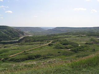
Dry Island Buffalo Jump Provincial Park is a provincial park in Central Alberta, Canada, located about 103 km (64 mi) southeast of Red Deer and 16 km (9.9 mi) northeast of Trochu, 1 mile north and 10 miles east of Huxley. The park is situated along the Red Deer River and features badlands topography. Its name derives from the large plateau in the middle of the park, 200 m (660 ft) above the Red Deer River, which has never been developed by humans and retains virgin prairie grasses.
The Elk Valley is a valley in the southeastern Kootenay region of British Columbia, Canada. Located in the heart of the Canadian Rockies, the Elk Valley is approximately 60 kilometres from the Alberta and Montana borders.

The Ghost River Wilderness Area is a provincially designated wilderness area in the Canadian Rockies of Alberta protecting the headwaters of the Ghost River. It was established in 1967 and it, as one of the three wilderness areas of Alberta, has the strictest form of government protection available in Canada. All development is forbidden, and only travel by foot is permitted. Hunting and fishing are not allowed. The other two wilderness areas are White Goat Wilderness Area and Siffleur Wilderness Area and together the three areas total 1,009.8882 square kilometres.

Northern Alberta is a geographic region located in the Canadian province of Alberta.
Jarvis Bay Provincial Park is a provincial park in Alberta, Canada, located 4 km (2.5 mi) north from Sylvan Lake and 35 km (22 mi) west from Red Deer, along Highway 20.
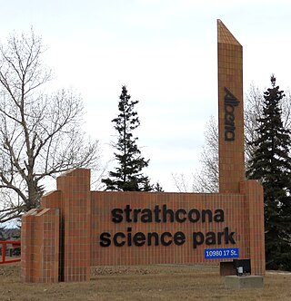
Strathcona Science Provincial Park is a provincial park in Alberta, Canada, located between Edmonton and Sherwood Park, south of the Yellowhead Highway and west of Anthony Henday Drive.

Peace River Wildland Provincial Park is located in the valley of the Peace River stretching from Dunvegan Provincial Park to the Smoky River confluence and 30 kilometers upstream of the Smoky River valley. Also included in the park is the Spirit River valley at the confluence with the Peace. While most of the park lies in the Birch Hills County, some of it is in the Northern Sunrise County immediately south of the Town of Peace River.

The Rural Municipality of Moose Range No. 486 is a rural municipality (RM) in the Canadian province of Saskatchewan within Census Division No. 14 and SARM Division No. 4.
The Heart River is a river in northern Alberta, Canada. It is a major tributary of the Peace River.

The White Goat Wilderness Area is a provincially designated wilderness area in the Canadian Rockies of Alberta. It was established in 1961 and it, as one of the three wilderness areas of Alberta, has the strictest form of government protection available in Canada. All development is forbidden and only travel by foot is permitted. Hunting and fishing are not allowed. The other two wilderness areas are Ghost River Wilderness Area and Siffleur Wilderness Area and together the three areas total 249,548.80 acres (100,988.82 ha).

The Siffleur Wilderness Area is a provincially designated wilderness area in the Canadian Rockies of Alberta. It was established in 1961 and it, as one of the three wilderness areas of Alberta, has the strictest form of government protection available in Canada. All development is forbidden and only travel by foot is permitted. Hunting and fishing are not allowed. The other two wilderness areas are White Goat Wilderness Area and Ghost River Wilderness Area and together the three areas total 249,548.80 acres (100,988.82 ha).

Eagle Point Provincial Park is a provincial park in central Alberta, Canada. It is located along the banks of the North Saskatchewan River within Brazeau County to the east and northeast of the Town of Drayton Valley. Recreation in Eagle Point Provincial Park include, Canoeing, Biking, Hiking, and Fishing. Animals within the park include Pine Martens, River Otters, North American beaver, American Black Bear, Belted Kingfisher, Osprey, Great Grey Owl, and Mule Deer.
Hudson Bay Regional Park is a regional park in the Canadian province of Saskatchewan. It is located on the south side of the town of Hudson Bay in the RM of Hudson Bay No. 394 along the shores of the Red Deer River. The park is the site of a North West Company fur trading fort called Fort Red Deer River that was built in 1790. About 14 kilometres (8.7 mi) downstream, near Erwood, was a Hudson's Bay Company trading post that was built in 1757.