Geography of Saskatchewan

Last updated

Geography of Saskatchewan
Saskatchewan-relief.png
Continent North America
Region Western Canada
Canadian Prairies
Coordinates 49°00′00″N101°21′41″W / 49.00000°N 101.36139°W / 49.00000; -101.36139
60°00′N110°00′W / 60.000°N 110.000°W / 60.000; -110.000
Area Ranked 7th among provinces
  Total651,036 km2 (251,366 sq mi)
  Land90.8%
  Water9.2%
Coastline0 km (0 mi)
Borders Alberta, Manitoba, Northwest Territories, Montana and North Dakota
Highest point Cypress Hills
1,468 metres (4,816 ft)
Lowest point Lake Athabasca
213 metres (699 ft)
Longest river Saskatchewan River
Largest lake Lake Athabasca
7935 km2

The geography of Saskatchewan is unique among the provinces and territories of Canada in some respects. It is one of only two landlocked regions (Alberta is the other) and it is the only region whose borders are not based on natural features like lakes, rivers, or drainage divides. The borders of Saskatchewan, which make it very nearly a trapezoid, were determined in 1905 when it became a Canadian province. Saskatchewan has a total area of 651,036 square kilometres (251,366 sq mi) of which 591,670 km2 (228,450 sq mi) is land and 59,366 km2 (22,921 sq mi) is water. [1]

Contents

The province's name comes from the Saskatchewan River, whose Cree name is: kisiskatchewani sipi, meaning "swift flowing river". [2]

Saskatchewan can be divided into three regions: grassland (part of the Great Plains) in the south, aspen parkland in the centre, and forest in the north. The forest region lies partly on the northern part of the Great Plains and partly on the Canadian Shield. Its principal rivers are the Assiniboine River, and North and South Saskatchewan Rivers.

NASA image of Saskatchewan and a portion of Manitoba. Dark to light rust coloured areas in the north are burn scars from forest fires NASA image of Saskatchewan.jpg
NASA image of Saskatchewan and a portion of Manitoba. Dark to light rust coloured areas in the north are burn scars from forest fires

Saskatchewan is bordered on the west by Alberta, on the north by the Northwest Territories, on the east by Manitoba, and on the south by the U.S. states of Montana and North Dakota.

Physical geography

Saskatchewan is very close to a trapezoid. Its western border runs concurrent with the 4th meridian or the 110°W longitude, separating Saskatchewan from the province of Alberta. This border extends in length for 1,225 kilometres (761 mi) and was established in 1905 when both provinces were formed. [3]

Saskatchewan's eastern border includes minor measurement errors from the 1880s, so that it does not lie perfectly on the 102°W longitude, but rather it is slightly west of that meridian from 60°N parallel to 55°47'N, then slightly east of that until the Canada–United States border an irregular line (rather than a straight one) for its 1,225-kilometre (761 mi) distance. [4] When Saskatchewan was formed in 1905, Manitoba and the District of Keewatin were the neighbouring areas to the east. Manitoba was enlarged in 1912 north to the 60th parallel, becoming Saskatchewan's only eastern neighbour. This remaining section of the border was determined by survey between 1961 and 1972. [3]

Saskatchewan's southern border with the United States sits approximately on the 49th parallel, as agreed in the Treaty of 1818 though minor measurement errors during the 1870s International Boundary Survey result in some variance between the actual Canada–United States border and the 49th parallel. [5] This boundary was not formally established until the 1867 survey. [3] This border extends 627 kilometres (390 mi) across southern Saskatchewan.

The Northwest Territories is north of the 60th parallel which forms the northern border of the province. [6] This border extends 445 kilometres (277 mi) across northern Saskatchewan. [3] The aforementioned measurement errors in the 1880s surveys place the Saskatchewan / Manitoba border approximately 400 metres (440 yd) west of the 102nd meridian and the accurately measured Northwest Territories / Nunavut border, just missing a true quadripoint of the Saskatchewan / Manitoba/Northwest Territories / Nunavut borders.

Geology

The geology of Saskatchewan can be divided into two main geological regions, the Pre-Cambrian or Canadian shield and the Phanerozoic or Western Canada Sedimentary Basin. Within the Canadian shield exists the Athabasca sedimentary basin. Meteorite impacts have altered the natural geological formation processes. The Quaternary period is the most recent geological process when the prairies were affected by glacial events. [7] There are six notable meteorite or comet impact craters in Saskatchewan. Carswell, Deep Bay and Gow Lake have affected the Canadian Shield area of the north. In the southern Phanerozoic crater are the Viewfield, Elbow and Maple Creek structures. [8] The Carswell structure is the largest astrobleme at 35 kilometres (22 mi) in diameter. [9]

Historical geography

Archaeologists have dated the first human settlements to 9,500 BC. The four groups inhabiting the area at the time of the first European contact were the Cree, Assiniboine, Salteaux, and Dene. [10] Henry Kelsey of the Hudson's Bay Company is considered the first European person to see this area. The earliest trading posts were made by the French; however, the first permanent settlement was established at Cumberland House in 1774 by the HBC. In addition, several more ports were set up by British fur traders among the area's waterways. The forested area of the Canadian Shield was the favoured area for early settlement, and the economy was heavily dependent on hunting and trapping.

In 1870, the Hudson's Bay Company sold Rupert's Land and ceded its rights to the Canadian Government. [10] The region became a part of the North-West Territories. The majority of the Indigenous inhabitants in the North-West Territories made treaties with the British Crown (via Canadian government representatives) in the 1870s and were settled on Indian reserves.[ citation needed ] Additional native peoples and Métis, led by Louis Riel, rebelled between 1884 and 1885 in the North-West Rebellion and were suppressed.

The arrival of settlements and the rail lines also brought agricultural economies and development in the Central Lowlands Area. The Great Plains or Palliser Triangle area to the south was mainly used for ranching economies. In the beginning of the 20th century, Saskatchewan farmers created cooperative organizations to maintain grain marketization. During the drought and the Great Depression of the 1930s, the population decreased as immigration nearly ended and numerous families left. During World War II, conservation programs and the increased demand for grain revived the economy.

Climate

Koppen climate types in Saskatchewan Saskatchewan Koppen.svg
Köppen climate types in Saskatchewan

Being in the centre of North America, Saskatchewan is far removed from the moderating effects of any large body of water and therefore has a temperate continental climate, Köppen climate classification types BSk, Dfb and Dfc. Hot to warm summers and cold winters mean that the annual temperature range can be up to 65 °C. [11] On average, Saskatchewan has 211 days per year when the temperature drops below freezing. [12] Plough winds, Supercell hail or high precipitation rain storms, and tornadoes are eventful summer occurrences. Midale reached 45 °C (113 °F) on July 5, 1937, one of the highest recorded temperatures in Canada. [11]

Compared to average values from all thirteen Canadian provinces and territories, [12] Saskatchewan is the sunniest province or territory year round (2206 hours per year), has the second-lowest annual snowfall (145 centimetres (57 in)), the fourth-lowest total precipitation (428 millimetres (16.9 in)) and the second-hottest summer (22.5 °C (72.5 °F)). The number of frost-free days ranges from 95 days in the north (Prince Albert, for example) to as high as 124 days in the south (Estevan). [13]

Climate data

Average daily maximum and minimum temperatures for selected cities in Saskatchewan [14]
CityJuly (°C)July (°F)January (°C)January (°F)
Maple Creek 27/1181/52−5/−1623/4
Estevan 27/1381/55−9/−2016/−4
Weyburn 26/1279/54−10/−2114/−6
Moose Jaw 26/1279/54−8/−1918/−2
Regina 26/1179/52−10/−2214/−8
Saskatoon 25/1177/52−12/−2210/−8
Melville 25/1177/52−12/−2310/−9
Swift Current 25/1177/52−7/−1719/1
Humboldt 24/1175/52−12/−2310/−9
Melfort 24/1175/52−14/−237/−9
North Battleford 24/1175/52−12/−2210/−8
Yorkton 24/1175/52−13/−239/−9
Lloydminster 23/1173/52−10/−1914/−2
Prince Albert 24/1175/52−13/−259/−13

Climate change

The effects of climate change in Saskatchewan are now being observed in parts of the province. There is evidence of reduction of biomass in Saskatchewan's boreal forests [15] (as with those of other Canadian prairie provinces) is linked by researchers to drought-related water stress, stemming from global warming, most likely caused by greenhouse gas emissions. While studies, as early as 1988 (Williams, et al., 1988) have shown climate change will affect agriculture, [16] whether the effects can be mitigated through adaptations of cultivars, or crops, is less clear. Resiliency of ecosystems may decline with large changes in temperature. [17] The provincial government has responded to the threat of climate change by introducing a plan to reduce carbon emissions, "The Saskatchewan Energy and Climate Change Plan", in June 2007.

Urban areas

Saskatchewan's capital and second largest city is Regina. Its most populous city is Saskatoon.

Biosphere

Flora

View of Qu'Appelle Valley Qu'Appelle Valley near Cutarm, Sask., circa 1910.jpeg
View of Qu'Appelle Valley

The native flora of the Saskatchewan includes vascular plants, plus additional species of other plants and plant-like organisms such as algae, lichens and other fungi, and mosses. [20] Non-native species of plants are recorded as established outside of cultivation in Saskatchewan, of these some non-native species remain beneficial for gardening, and agriculture, where others have become invasive, noxious weeds. [21] [22] Saskatchewan is committed to protecting species at risk in Canada. [23] The growing season has been studied and classified into plant hardiness zones depending on length of growing season and climatic conditions. Biogeographic factors have also been divided into ecoregions and floristic kingdoms across Saskatchewan, and natural vegetation varies depending on elevation, moisture, soil and weather. [24] [25] [26] The study of ethnobotany uncovers the interrelation between humans and plants and the various ways people have used plants for economic reasons, food, medicine and technological developments. [27] [28]

The Government of Saskatchewan has declared three indigenous plants as provincial symbols. [29]

Saskatchewan Terrain within rectangle
Red area Canadian Shield
Green area Central Lowlands
Southwest corner Great Plains Sk-terrain.jpg
Saskatchewan Terrain within rectangle
Red area Canadian Shield
Green area Central Lowlands
Southwest corner Great Plains

Fauna

The fauna of Saskatchewan include many land and aquatic species. From the multiplicity of invertebrates and vertebrates two have been chosen as symbols of Saskatchewan, the white-tailed deer and the sharp-tailed grouse. [30] Cenozoic vertebrate fossils reveal the geological evolution of the interior plains and its prehistoric biogeography. [31] Today, Saskatchewan's ecosystems range from the sub-arctic tundra of the Canadian Shield in north Saskatchewan to aspen parkland, and grassland prairie. [32] Fauna inhabit areas unique to their own specific and varied breeding, foraging and nesting requirements. [25] With a large land and water area, and small population density, the ecoregions of Saskatchewan provide important habitat for many animals, both endangered and not. [33]

Naturalists observing wildlife have enumerated shrinking and growing wildlife populations. They advocate programs and methods to preserve or re-introduce endangered species and identify programs of control for outbreaks of wildlife populations. [34]

A broad diversity of wildlife habitats are preserved as parks and reserves protecting the feeding and breeding grounds of protected and indigenous fauna of Saskatchewan. [31] [35]

Hydrography

The total area of freshwater is 59,366 km2. [1] [36] There are two main river basins, the Nelson and Churchill River Basins, both of which drain into Hudson Bay. [37]

Qu'Appelle and Souris, the North and South Saskatchewan, confluence is east of Prince Albert becoming the Saskatchewan which are all a part of the Nelson river basin. The Churchill River connects lakes and streams through the lower portion of the Canadian Shield. [38] Rupert's Land a historical political division of Canada comprised all lands of the Hudson Bay drainage system between the years 1670 to 1870. [39] [40]

Frenchman River does not flow east to Hudson Bay, but rather south to the Missouri River, which is part of the Missouri river basin catchment area. The Mackenzie River basin of north Saskatchewan flows north draining into the Arctic Ocean, which belongs to the Mackenzie river basin drainage area. [37] [38]

There are over 10,000 lakes across Saskatchewan, the main lake region being north of the tree line in the Canadian Shield. [41]

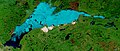
Saskatchewan's largest lake is Lake Athabasca which sits astride the Saskatchewan – Alberta border. The second in size is Reindeer Lake which is located on the Saskatchewan – Manitoba border. Other lakes of notable size would be Wollaston, Cree, Frobisher, and Lac La Ronge. [38] The deepest water point 220 metres (720 ft) is located in Reindeer Lake at the Deep Bay Structure site which was created by a meteor impact. [9] [42]

Saskatchewan is also home to preserved wetlands which are partially submerged areas of land. [43]

Saskatchewan's waterways also contain bogs, as well as the salt water lakes. Quill Lake is Canada's largest saltwater lake, Chaplin Lake is a Western Hemispheric Shorebird Reserve Network and Little Manitou, an endorheic lake, is a popular tourist resort. Brine shrimp fisheries have existed on sodium magnesium sulphate lakes such as Chaplin, Frederick, Ingebright, and Little Manitou lakes. [44] [45]

Provincial and national parks

Saskatchewan has 36 provincial parks that provide for recreational use or preserve wilderness, special environments, or sites of historic importance. [46]

The province is also home to two of Canada's 36 National Parks. Grasslands National Park, which covers 907 square kilometres (350 sq mi) in southernmost part of the province, was established in 1981. [47] The other is Prince Albert National Park covering 3,874 square kilometres (1,496 sq mi) in central Saskatchewan, which was established in 1927. [48]

Economic geography

The economy of Saskatchewan has been associated with agriculture resulting in the moniker Bread Basket of Canada [49] and Bread Basket of the World. [50] According to the Government of Saskatchewan, approximately 95% of all items produced in Saskatchewan, depend on the basic resources available within the province. Various grains, livestock, oil and gas, potash, uranium, wood and their spin off industries fuel the economy. [51]

Saskatchewan's GDP in 2006 was approximately C$45.922 billion. [52]

See also

Related Research Articles

<span class="mw-page-title-main">Alberta</span> Province of Canada

Alberta is one of the thirteen provinces and territories of Canada. It is a part of Western Canada and is one of the three prairie provinces. Alberta is bordered by British Columbia to the west, Saskatchewan to the east, the Northwest Territories to the north, and the U.S. state of Montana to the south. It is one of the only two landlocked provinces in Canada, with Saskatchewan being the other. The eastern part of the province is occupied by the Great Plains, while the western part borders the Rocky Mountains. The province has a predominantly continental climate but experiences quick temperature changes due to air aridity. Seasonal temperature swings are less pronounced in western Alberta due to occasional Chinook winds.

<span class="mw-page-title-main">Geography of Canada</span>

Canada has a vast geography that occupies much of the continent of North America, sharing a land border with the contiguous United States to the south and the U.S. state of Alaska to the northwest. Canada stretches from the Atlantic Ocean in the east to the Pacific Ocean in the west; to the north lies the Arctic Ocean. Greenland is to the northeast with a shared border on Hans Island. To the southeast Canada shares a maritime boundary with France's overseas collectivity of Saint Pierre and Miquelon, the last vestige of New France. By total area, Canada is the second-largest country in the world, after Russia. By land area alone, however, Canada ranks fourth, the difference being due to it having the world's largest proportion of fresh water lakes. Of Canada's thirteen provinces and territories, only two are landlocked while the other eleven all directly border one of three oceans.

<span class="mw-page-title-main">Geography of North Macedonia</span> Overview of the geography of North Macedonia

North Macedonia is a country situated in southeastern Europe with geographic coordinates 41°50′N22°00′E, bordering Kosovo and Serbia to the north, Bulgaria to the east, Greece to the south and Albania to the west. The country is part of the wider region of Macedonia and makes up most of Vardar Macedonia. The country is a major transportation corridor from Western and Central Europe to Southern Europe and the Aegean Sea. North Macedonia is a landlocked country but has three major natural lakes: Lake Ohrid, Lake Prespa and Lake Dojran. It has a water area of 857 km2, while its land area is 24,856 km2.

<span class="mw-page-title-main">Saskatchewan</span> Province of Canada

Saskatchewan is a province in Western Canada, bordered on the west by Alberta, on the north by the Northwest Territories, on the east by Manitoba, to the northeast by Nunavut, and on the south by the United States. Saskatchewan and Alberta are the only landlocked provinces of Canada. In 2023, Saskatchewan's population was estimated at 1,221,439. Nearly 10% of Saskatchewan's total area of 651,900 km2 (251,700 sq mi) is fresh water, mostly rivers, reservoirs, and lakes.

<span class="mw-page-title-main">Prince Albert, Saskatchewan</span> City in Saskatchewan, Canada

Prince Albert is the third-largest city in Saskatchewan, Canada, after Saskatoon and Regina. It is situated near the centre of the province on the banks of the North Saskatchewan River. The city is known as the "Gateway to the North" because it is the last major centre along the route to the resources of northern Saskatchewan. Prince Albert National Park is located 51 km (32 mi) north of the city and contains a wealth of lakes, forest, and wildlife. The city itself is located in a transition zone between the aspen parkland and boreal forest biomes. Prince Albert is surrounded by the Rural Municipality of Prince Albert No. 461, of which it is the seat, but is politically separate.

<span class="mw-page-title-main">Geography of Quebec</span> Geography of Quebec, Canadas largest province

Located in the eastern part of Canada, and part of Central Canada, Quebec occupies a territory nearly three times the size of France or Texas. It is much closer to the size of Alaska. As is the case with Alaska, most of the land in Quebec is very sparsely populated. Its topography is very different from one region to another due to the varying composition of the ground, the climate, and the proximity to water. The Great Lakes–St. Lawrence Lowlands and the Appalachians are the two main topographic regions in southern Quebec, while the Canadian Shield occupies most of central and northern Quebec.

<span class="mw-page-title-main">Geography of Alberta</span>

Alberta is one of the thirteen provinces and territories of Canada. Located in Western Canada, the province has an area of 661,190 km2 (255,290 sq mi) and is bounded to the south by the United States state of Montana along 49° north for 298 km (185 mi); to the east at 110° west by the province of Saskatchewan for 1,223 km (760 mi); and at 60° north the Northwest Territories for 644 km (400 mi). The southern half of the province borders British Columbia along the Continental Divide of the Americas on the peaks of the Rocky Mountains, while the northern half borders British Columbia along the 120th meridian west. Along with Saskatchewan it is one of only two landlocked provinces or territories.

<span class="mw-page-title-main">Canadian Prairies</span> Region of Western Canada

The Canadian Prairies is a region in Western Canada. It includes the Canadian portion of the Great Plains and the Prairie provinces, namely Alberta, Saskatchewan, and Manitoba. These provinces are partially covered by grasslands, plains, and lowlands, mostly in the southern regions. The northernmost reaches of the Canadian Prairies are less dense in population, marked by forests and more variable topography. If the region is defined to include areas only covered by prairie land, the corresponding region is known as the Interior Plains. Physical or ecological aspects of the Canadian Prairies extend to northeastern British Columbia, but that area is not included in political use of the term.

<span class="mw-page-title-main">Meadow Lake, Saskatchewan</span> City in Saskatchewan, Canada

Meadow Lake is a city in the boreal forest of northwestern Saskatchewan, Canada. Its location is about 246 kilometres (153 mi) northeast of Lloydminster and 156 kilometres (97 mi) north of North Battleford. Founded as a trading post in 1799, it became a village in 1931 and a town in 1936. On November 9, 2009, it officially became Saskatchewan's 14th city.

<span class="mw-page-title-main">Red Deer River</span> River in Alberta and Saskatchewan, Canada

The Red Deer River is a river in Alberta and a small portion of Saskatchewan, Canada. It is a major tributary of the South Saskatchewan River and is part of the larger Saskatchewan / Nelson system that empties into Hudson Bay.

<span class="mw-page-title-main">Geography of Ontario</span> Geographical features of Ontario

Ontario is located in East/Central Canada. It is Canada's second largest province by land area. Its physical features vary greatly from the Mixedwood Plains in the southeast to the boreal forests and tundra in the north. Ontario borders Manitoba to the west, Hudson Bay and James Bay to the north, Quebec to the east, and the Great Lakes and the United States to the south. The province is named for Great Lake Ontario, an adaptation of the Iroquois word Onitariio, meaning "beautiful lake", or Kanadario, variously translated as "beautiful water". There are approximately 250,000 lakes and over 100,000 kilometres (62,000 mi) of rivers in the province.

<span class="mw-page-title-main">Geography of Manitoba</span>

The geography of Manitoba addresses the easternmost of the three prairie Canadian provinces, located in the longitudinal centre of Canada. Manitoba borders on Saskatchewan to the west, Ontario to the east, Nunavut to the north, and the American states of North Dakota and Minnesota to the south. Although the border with Saskatchewan appears straight on large-scale maps, it actually has many right-angle corners that give the appearance of a slanted line. In elevation, Manitoba ranges from sea level on Hudson Bay to 2727 ft (831 m) on top of Baldy Mountain. The northern sixty percent of the province is on the Canadian Shield. The northernmost regions of Manitoba lie permafrost, and a section of tundra bordering Hudson Bay.

Highway 6 is a paved undivided major provincial highway in the Canadian province of Saskatchewan. It runs from Montana Highway 16 at the Canada–US border near the Canada customs port of Regway to Highway 55 near Choiceland. Highway 6 is about 523 km (325 mi) long. The CanAm Highway comprises Saskatchewan Highways from south to north: SK 35, Sk 39, Sk 6, Sk 3, as well as Sk 2. 330 kilometres (210 mi) of Saskatchewan Highway 6 contribute to the CanAm Highway between Corinne and Melfort.

Highway 3 is a major provincial highway in the Canadian province of Saskatchewan. It runs from the Alberta border, where it continues west as Alberta Highway 45, to the Manitoba border, and then continues east as Highway 77. Highway 3 is about 615 km (382 mi.) long. The CanAm Highway comprises Saskatchewan Highways 35, 39, 6, 3, as well as 2. 59.7 miles (96.1 km) of Saskatchewan Highway 3 contribute to the CanAm Highway between Melfort and Prince Albert.

<span class="mw-page-title-main">Broadview, Saskatchewan</span> Town in Saskatchewan, Canada

Broadview is a community in Saskatchewan along Highway 1, the Trans-Canada Highway, 155 kilometres (96 mi) east of Regina. The local economy is based mainly on agriculture. It is also the administrative headquarters of the Rural Municipality of Elcapo No. 154

<span class="mw-page-title-main">Rural Municipality of Victory No. 226</span> Rural municipality in Saskatchewan, Canada

The Rural Municipality of Victory No. 226 is a rural municipality (RM) in the Canadian province of Saskatchewan within Census Division No. 7 and SARM Division No. 3.

<span class="mw-page-title-main">Geology of Saskatchewan</span> Geologic features of the Canadian province

The geology of Saskatchewan can be divided into two main geological regions, the Precambrian Canadian Shield and the Phanerozoic Western Canadian Sedimentary Basin. Within the Precambrian shield exists the Athabasca sedimentary basin. Meteorite impacts have altered the natural geological formation processes. The prairies were most recently affected by glacial events in the Quaternary period.

<span class="mw-page-title-main">Flora of Saskatchewan</span>

The native flora of Saskatchewan includes vascular plants, plus additional species of other plants and plant-like organisms such as algae, lichens and other fungi, and mosses. Non-native species of plants are recorded as established outside of cultivation in Saskatchewan, of these some non-native species remain beneficial for gardening, and agriculture, where others have become invasive, noxious weeds. Saskatchewan is committed to protecting species at risk in Canada. The growing season has been studied and classified into plant hardiness zones depending on length of growing season and climatic conditions. Biogeographic factors have also been divided into vegetative zones, floristic kingdoms, hardiness zones and ecoregions across Saskatchewan, and natural vegetation varies depending on elevation, moisture, soil type landforms, and weather. The study of ethnobotany uncovers the interrelation between humans and plants and the various ways people have used plants for economic reasons, food, medicine and technological developments. The Government of Saskatchewan has declared 3 indigenous plants as provincial symbols.

References

  1. 1 2 "The Atlas of Canada: Land and freshwater areas". Natural Resources Canada (Federal Government). Archived from the original on 16 June 2008. Retrieved 7 January 2009.
  2. "Provinces and Territories – The origins of their names". Natural Resources Canada. Archived from the original on 23 January 2009. Retrieved 8 January 2009.
  3. 1 2 3 4 Lewry, Marilyn (2006). "Boundary surveys". The Encyclopedia of Saskatchewan. Canadian Plains Research Center, University of Regina. Archived from the original on 1 April 2012. Retrieved 6 January 2009.
  4. Thomson, Malcolm M.; Tanner, Richard W. (April 1977). "Canada's Prime Meridian". Journal of the Royal Astronomical Society of Canada. 71: 204. 1977JRASC..71..204T.
  5. Widdis, Randy (2006). "49th Parallel". The Encyclopedia of Saskatchewan. Canadian Plains Research Center, University of Regina. Archived from the original on 26 October 2008. Retrieved 6 January 2009.
  6. "The Atlas of Canada – Territorial Evolution, 1905". Natural Resources Canada. Government of Canada. 6 April 2004. Archived from the original on 12 December 2008. Retrieved 6 January 2009.
  7. "Introduction to Saskatchewan's Geology". Government of Saskatchewan. Retrieved 24 January 2009.[ permanent dead link ]
  8. Macdonald, R. (2006). "Geology". The Encyclopedia of Saskatchewan. Canadian Plains Research Center, University of Regina. Archived from the original on 19 June 2009. Retrieved 24 January 2009.
  9. 1 2 Harper, Charles (2006). "Astroblemes". The Encyclopedia of Saskatchewan Details. Canadian Plains Research Center, University of Regina. Retrieved 24 January 2009.
  10. 1 2 Cottrell, Michael. "Encyclopedia of Saskatchewan: History of Saskatchewan" . Retrieved 12 January 2009.
  11. 1 2 Cote, Mark. "Encyclopedia of Saskatchewan: Climate". Archived from the original on 1 September 2010. Retrieved 8 January 2009.
  12. 1 2 "Saskatchewan Weather Honours". Environment Canada. Archived from the original on 27 March 2009. Retrieved 10 January 2009.
  13. "Summary of Agriculture in Saskatchewan". Government of Saskatchewan. Archived from the original on 6 January 2009. Retrieved 10 January 2009.
  14. "National Climate Data and Information Archive". climate.weatheroffice.gc. Environment Canada. Archived from the original on 11 December 2009. Retrieved 2 September 2010.
  15. Ma, Zhihai; Peng, Changhui; Zhu, Qiuan; Chen, Huai; Yu, Guirui; Li, Weizhong; Zhou, Xiaolu; Wang, Weifeng; Zhang, Wenhua (2012). "Regional drought-induced reduction in the biomass carbon sink of Canada's boreal forests". Proceedings of the National Academy of Sciences of the United States of America. 109 (7): 2423–2427. Bibcode:2012PNAS..109.2423M. doi: 10.1073/pnas.1111576109 . PMC   3289349 . PMID   22308340.
  16. Williams, G.D.V., R.A. Fautley, K.H. Jones, R.B. Stewart, and E.E. Wheaton. 1988. "Estimating Effects of Climatic Change on Agriculture in Saskatchewan, Canada." p. 219-379. In M.L. Parry et al. (ed.) The Impact of Climatic Variations on Agriculture. Vol. 1 Assessment in Cool Temperate and Cold Regions. Reidel Publ. Co. Dordrecht.
  17. Riebsame. W.E. (1991). "Sustainability of the Great Plains in an Uncertain Climate." [ permanent dead link ]Great Plains Research Vol.1 No.1, University of Nebraska
  18. 1 2 "Community Profiles from the 2006 Census, Statistics Canada". Statistics Canada. Government of Canada. 22 December 2012. Retrieved 9 January 2009.
  19. 1 2 "Community Profiles from the 2011 Census, Statistics Canada". Statistics Canada. Government of Canada. 29 April 2014. Retrieved 29 April 2015.
  20. "University of Saskatchewan: Virtual Herbarium". Department of Biology. Retrieved 25 January 2009.
  21. "Saskatchewan Conservation Data Centre". About Government/News Releases/March 1999/Wild Plants and Animals Protected. 2008. Retrieved 25 January 2009.
  22. "Wild Plants and Animals Protected". About Agriculture/Production/Crops – Weeds/Invasive Alien Plant Program. Government of Saskatchewan. March 1999. Archived from the original on 30 May 2011. Retrieved 25 January 2009.
  23. "Wild Plants and Animals Protected". About Government/News Releases/March 1999/Wild Plants and Animals Protected. Government of Saskatchewan. March 1999. Archived from the original on 24 November 2010. Retrieved 25 January 2009.
  24. Haggett, Peter (2002). Encyclopedia of World Geography (Digitized online by Google books) (2, illustrated ed.). Marshall Cavendish. p. 355. ISBN   0-7614-7289-4 . Retrieved 25 January 2009.
  25. 1 2 ThorpeWapple, Robert (1999), "Wildlife", in Kai-iu Fung; Bill Barry; Wilson, Michael (eds.), Atlas of Saskatchewan Celebrating the Millennium, Andrew B. Didiuk Alan Smith, Bernie Gollop, Jennifer Merkowsky, Peter Jonker (Millennium ed.), Saskatchewan: University of Saskatchewan, pp. 138–168, ISBN   0-88880-387-7
  26. Coupland, R.T. (1969). "Natural Vegetation of Saskatchewan". In J.H. Richards; K.I. Fung (eds.). Atlas of Saskatchewan. J.S. Rowe. Saskatoon, SK, CA: University of Saskatchewan. pp. 72–78.
  27. Elias, Thomas S. (1983). Edible Wild Plants A North American Field Guide (Digitized online by Google books). Peter A. Dykeman. Cengage Learning. pp. 9–28 and 258. ISBN   0-442-22254-8 . Retrieved 25 January 2009.
  28. Johnson, Derek; Linda Kershaw; Andy Mackinnon; Jim Pojar (1995). Plants of the Western Boreal Forest and Aspen Parkland (Digitized online by Google books). Lone Pine Publishing and the Canadian Forest Service. pp. 11–21. ISBN   1-55105-058-7 . Retrieved 25 January 2009.
  29. Government of Saskatchewan (June 2008). "Saskatchewan's Provincial Tree" . Retrieved 5 April 2008.
  30. Government of Saskatchewan. "Symbols of Saskatchewan" . Retrieved 7 June 2009.
  31. 1 2 "Royal Saskatchewan Museum: Publications: Earth Sciences". Royal Saskatchewan Museum. 2009. Archived from the original (Abstract published online by JSTOR 2000-2008) on 29 August 2009. Retrieved 25 January 2009.
  32. "Saskatchewan Conservation Data Centre". Saskatchewan Conservation Data Centre. 2002. Retrieved 25 January 2009.
  33. "Narrative Descriptions of Terrestrial Ecozones and Ecoregions of Canada". The Green LaneTM, Environment Canada's World Wide Web site. Government of Canada. 11 April 2005. Archived from the original on 15 January 2009. Retrieved 26 January 2009.
  34. Sterling, Keir Brooks; C. Stuart Houston (1997). Biographical Dictionary of American and Canadian Naturalists and Environmentalists (Digitized online by Google books) (illustrated ed.). Greenwood Publishing Group. pp. 267–269. ISBN   0-313-23047-1 . Retrieved 25 January 2009.
  35. Maher, W.J. (1969). "Zoogeography". In J.H. Richards; K.I. Fung (eds.). Atlas of Saskatchewan. F.J. Atton, J.B. Gollop. Saskatoon, SK, CA: University of Saskatchewan. pp. 79–105.
  36. "Land and Freshwater area by province". Statistics Canada. Government of Canada. 1 February 2005. Archived from the original on 24 May 2011. Retrieved 5 April 2007.
  37. 1 2 Benke, Arthur C.; Cushing, Colbert E. (2005). Rivers of North America: The Natural History. Academic Press. pp. 853–903. ISBN   0-12-088253-1 . Retrieved 6 January 2009.
  38. 1 2 3 "Saskatchewan (province) – MSN Encarta". Microsoft. 2008. Archived from the original on 28 October 2009. Retrieved 6 January 2009.
  39. "The Atlas of Canada – Drainage Patterns". Natural Resources Canada. Government of Canada. 14 March 2003. Archived from the original on 9 December 2008. Retrieved 6 January 2009.
  40. Smith, Shirlee Anne (2008). "Rupert's Land". Microsoft. Archived from the original on 20 May 2004. Retrieved 6 January 2009.
  41. "Saskatchewan Council for Archives and Archivists – The Saskatchewan Landscape". Saskatchewan Council for Archives and Archivists. University of Saskatchewan. 2004.
  42. "Geoscape Northern SaskatchewanGeoscience for our Canadian Shield Community – Meteorite impact". Government of Canada. 7 January 2008. Archived from the original on 16 January 2008. Retrieved 29 December 2007.{{cite journal}}: Cite journal requires |journal= (help)
  43. "The Atlas of Canada – Wetlands". Natural Resources Canada. Government of Canada. 14 March 2003. Archived from the original on 13 June 2008. Retrieved 6 January 2009.
  44. Hammer, Ulrich Theodore; Cushing, Colbert E. (1986). Saline Lake Ecosystems of the World. Springer. pp. 55–57. ISBN   90-6193-535-0 . Retrieved 6 January 2009.
  45. "Canada Facts: Saskatchewan". Education Canada Network. Government of Canada. 1996–2008. Retrieved 6 January 2009.
  46. "Provincial Parks". Tourism Saskatchewan. Retrieved 13 January 2009.
  47. "Grasslands National Park of Canada". Parks Canada. Retrieved 13 January 2009.
  48. "Prince Albert National Park of Canada". Parks Canada. Archived from the original on 2 March 2007. Retrieved 13 January 2009.
  49. Giannetta, J. "SASKATCHEWAN economy (oil and gas, mining, farming, forestry, food processing, dams and reservoirs, electricity)". Sask web pages. Archived from the original on 27 February 2009. Retrieved 16 January 2009.
  50. "Immigration to Canada: Saskatchewan". Abrams & Krochak – Canadian Immigration Lawyers. 2008. Retrieved 16 January 2009.
  51. "Saskatchewan's Economy -". About Saskatchewan/Economy. Government of Saskatchewan. Archived from the original on 19 December 2008. Retrieved 16 January 2009.
  52. "Gross domestic product, expenditure-based, by province and territory". Statistics Canada . Government of Canada. 6 November 2008. Archived from the original on 20 April 2008. Retrieved 16 January 2009.

Further reading