Flin Flon

Last updated
Flin Flon
City of Flin Flon
Main Street of Flin Flon 2.jpg
Main Street of Flin Flon
Flin Flon Flag.svg
540 Flin Flon, Manitoba.svg
City boundaries
Canada location map 2.svg
Red pog.svg
Flin Flon
Location in Canada
Canada Manitoba location map 2.svg
Red pog.svg
Flin Flon
Location in Manitoba
Coordinates: 54°46′0″N101°52′40″W / 54.76667°N 101.87778°W / 54.76667; -101.87778
CountryCanada
Provinces Manitoba and
Saskatchewan
District (Saskatchewan) Northern Saskatchewan Administration District
Region (Manitoba) Northern Manitoba
Founded1927
IncorporatedJanuary 1, 1933
Government
  MayorGeorge Fontaine [1]
  CouncilFlin Flon City Council
   MP Niki Ashton (NDP, MB)
Gary Vidal (CPC, SK)
   MLA Tom Lindsey (NDP, MB)
Doyle Vermette (NDP, SK)
Area
[2]
  Land11.55 km2 (4.46 sq mi)
Elevation
300 m (980 ft)
Population
 (2021) [3]
  Total5,099
Time zone UTC-6 (CST)
  Summer (DST) UTC-5 (CDT)
Forward sortation area
R8A
Area code 204
Website http://www.cityofflinflon.ca/

Flin Flon (pop. 5,185 in 2016 census; 4,982 in Manitoba and 203 in Saskatchewan) is a mining city, located on a correction line on the border of the Canadian provinces of Manitoba and Saskatchewan, with the majority of the city located within Manitoba. Residents thus travel southwest into Saskatchewan, and northeast into Manitoba. The city is incorporated in and is jointly administered by both provinces.

Contents

Etymology

The town is named after the fictional character Josiah Flintabbatey Flonatin. Flinty Statue 2.jpg
The town is named after the fictional character Josiah Flintabbatey Flonatin.

The town's name is taken from the lead character in a 1905 paperback novel, The Sunless City by J. E. Preston Muddock. Josiah Flintabbatey Flonatin piloted a submarine into a bottomless lake where he sailed through a hole lined with gold to enter a strange underground world. A copy of the book was allegedly found and read by prospector Tom Creighton.

When Tom Creighton discovered a high-grade exposure of copper, he thought of the book and called it Flin Flon's mine, and the town that developed around the mine adopted the name. Flin Flon shares the distinction of being named after a character in an adventure novel with Tarzana, California and Le Plessis-Robinson, France.

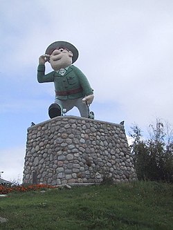
The character of "Flinty", as he is locally known, is of such importance to the identity of the city that in 2003, the local Chamber of Commerce commissioned the minting of a $3.00 coin which was considered legal tender amongst locally participating retailers until September 2004 and a $5.00 coin [4] which was in circulation until December 31, 2008. [5] A statue representing Flinty was designed by cartoonist Al Capp and is one of the points of interest of the city. In 1978, the National Film Board of Canada produced the short documentary Canada Vignettes: Flin Flon about the origin of the city's name. [6]

History

Flin Flon was founded in 1927 by Hudson Bay Mining and Smelting (Hudbay) to exploit the large local copper and zinc ore resources. In the late 1920s, HBM&S invested in a railway, mine, smelter, and a hydroelectric power plant at Island Falls, Saskatchewan. By 1928, the rail line reached the mine.

The town grew considerably during the 1930s as those impoverished by the Great Depression came to work at the mines. A significant number of farmers abandoned their farms and were among those looking for work. The municipality was incorporated on January 1, 1933, and reached city status in 1970. The city has continued to be a mining centre with the development of several mines adding to its industrial base, although its population has been in decline since the 1960s. With a scenic setting and a number of nearby lakes, Flin Flon has also become a popular tourist destination.

Geography

Flin Flon in the fall Flin Flon in the Fall.JPG
Flin Flon in the fall
Lake Athapapuskow, near Bakers Narrows Provincial Park and the airport; the photo was taken in late May, demonstrating that snow is possible (though unlikely) even that late in the year. 2009-0520-WhitneyLake-FlinFlon.JPG
Lake Athapapuskow, near Bakers Narrows Provincial Park and the airport; the photo was taken in late May, demonstrating that snow is possible (though unlikely) even that late in the year.

Flin Flon straddles the provincial boundary of Manitoba and Saskatchewan with the majority of the city located in Manitoba. The 2016 census reported 4,982 residents in the Manitoba portion and 203 in the Saskatchewan section; the Manitoba portion has a land area of 13.88 km2 (5.4 sq mi), while the Saskatchewan portion has a land area of 2.37 km2 (0.91 sq mi). Due to the zig-zag nature of the Saskatchewan-Manitoba boundary correction lines, the Saskatchewan section of town lies south of the Manitoba section, not west. Main Street crosses the provincial boundary just south of its intersection with Church Street; Hudson Street crosses the provincial boundary between its intersections with 5 Ave E. and Harrison Street, adopting the new name South Hudson Street at the point of crossing; an undeveloped stretch of Channing Drive briefly crosses into Saskatchewan before reentering Manitoba just west of the city's rural Channing neighbourhood.

For Canada Post purposes, residents in the Saskatchewan portion of the city retain the local Manitoba R8A postal code, and often use a Flin Flon, MB address. [7] For telephone service, however, they are located in Saskatchewan's area code 306 as part of the Creighton telephone exchange, rather than Manitoba's area code 204, which causes difficulties with emergency services. A resident in the Saskatchewan section of the city who calls 911 in an emergency will have services dispatched from Creighton rather than Flin Flon, and must instead call a regular phone number to receive immediate city-based service. [8] However, residents in Saskatchewan may use either Saskatchewan's SaskTel or Manitoba's Bell MTS systems for cellular services. [7] Electrical service is received from Manitoba Hydro for both the Manitoba and Saskatchewan parts of the city. [7]

The majority of Flin Flon's surface topology is exposed Canadian Shield bedrock, hence the nickname "the city built on rock". Due to this and climatic factors, agriculture is generally not possible although grain farming is found 130 kilometres (80 mi) southeast in The Pas, Manitoba, which is south of the Canadian Shield. The extensive bedrock exposure led to some interesting adaptations. In the northwestern areas of the city, there is often not enough overburden to bury water and sewer lines, so "sewer boxes" exist above surface to house the infrastructure. Many of these are used as ad-hoc sidewalks.

Climate

Flin Flon experiences a humid continental climate (Köppen climate classification Dfb). There is a wide range in seasonal temperatures, with warm summers and bitterly cold winters. Temperatures in January have an average low of −22.9 °C (−9.2 °F) and an average high of −14.7 °C (5.5 °F). Temperatures in July have an average high of 24.1 °C (75.4 °F) and an average low of 13.6 °C (56.5 °F). [9] The highest (reliable) [lower-alpha 1] temperature ever recorded in Flin Flon was 101 °F (38.3 °C) on 19 July 1941. [12] The coldest temperature ever recorded was −51 °F (−46.1 °C) on 15 January 1930. [9]

Climate data for Flin Flon, 1981–2010 normals, extremes 1927–present
MonthJanFebMarAprMayJunJulAugSepOctNovDecYear
Record high °C (°F)9.5
(49.1)
11.7
(53.1)
18.0
(64.4)
29.4
(84.9)
33.5
(92.3)
36.0
(96.8)
38.3
(100.9)
35.6
(96.1)
32.5
(90.5)
25.0
(77.0)
15.5
(59.9)
8.3
(46.9)
38.3
(100.9)
Mean daily maximum °C (°F)−14.7
(5.5)
−10.2
(13.6)
−2.1
(28.2)
7.3
(45.1)
15.0
(59.0)
21.1
(70.0)
24.1
(75.4)
22.6
(72.7)
15.0
(59.0)
6.3
(43.3)
−5.0
(23.0)
−12.4
(9.7)
5.6
(42.1)
Daily mean °C (°F)−18.9
(−2.0)
−14.9
(5.2)
−7.6
(18.3)
1.8
(35.2)
9.4
(48.9)
15.8
(60.4)
18.9
(66.0)
17.5
(63.5)
10.8
(51.4)
3.0
(37.4)
−8.0
(17.6)
−16.2
(2.8)
1.0
(33.8)
Mean daily minimum °C (°F)−22.9
(−9.2)
−19.6
(−3.3)
−13.0
(8.6)
−3.6
(25.5)
3.8
(38.8)
10.4
(50.7)
13.6
(56.5)
12.4
(54.3)
6.5
(43.7)
−0.4
(31.3)
−11.0
(12.2)
−20.0
(−4.0)
−3.6
(25.5)
Record low °C (°F)−46.1
(−51.0)
−43.3
(−45.9)
−40.0
(−40.0)
−29.4
(−20.9)
−15.0
(5.0)
−2.8
(27.0)
0.0
(32.0)
0.0
(32.0)
−10.0
(14.0)
−21.7
(−7.1)
−34.4
(−29.9)
−43.3
(−45.9)
−46.1
(−51.0)
Average precipitation mm (inches)17.5
(0.69)
16.7
(0.66)
15.1
(0.59)
20.3
(0.80)
40.9
(1.61)
69.0
(2.72)
77.9
(3.07)
63.7
(2.51)
63.4
(2.50)
29.0
(1.14)
21.7
(0.85)
22.5
(0.89)
457.6
(18.02)
Average rainfall mm (inches)0.0
(0.0)
0.0
(0.0)
0.2
(0.01)
7.9
(0.31)
39.3
(1.55)
69.3
(2.73)
77.9
(3.07)
63.7
(2.51)
64.2
(2.53)
21.0
(0.83)
1.1
(0.04)
0.0
(0.0)
344.5
(13.56)
Average snowfall cm (inches)17.5
(6.9)
16.7
(6.6)
15.0
(5.9)
12.4
(4.9)
1.6
(0.6)
0.0
(0.0)
0.0
(0.0)
0.0
(0.0)
0.7
(0.3)
8.1
(3.2)
20.6
(8.1)
22.9
(9.0)
115.5
(45.5)
Average precipitation days (≥ 0.2 mm)6.65.64.64.68.69.912.210.410.67.46.46.693.5
Average rainy days (≥ 0.2 mm)0.00.00.112.18.410.012.210.410.55.40.360.059.3
Average snowy days (≥ 0.2 cm)7.05.64.62.50.380.040.00.00.202.36.06.735.3
Source: Environment Canada [9] [12] [13] [14] [15]
Flin Flon Wilderness and Outcrop.jpg
Canadian Shield geography in the Flin Flon region

Demographics

Combined population history of both portions of the City of Flin Flon
YearPop.±%
19312,374    
19418,860+273.2%
19519,899+11.7%
195610,771+8.8%
196111,106+3.1%
196610,201−8.1%
19719,344−8.4%
19768,560−8.4%
19818,261−3.5%
19867,591−8.1%
19917,449−1.9%
1996 6,861−7.9%
2001 6,267−8.7%
2006 5,836−6.9%
2011 5,634−3.5%
2016 5,185−8.0%
2021 5,099−1.7%
Source: [16] [17] [18] [19] [20] [21] [22] [23] [24] [25] [26] [27] [28] [29] [30] [31] [32]
Population history of the Saskatchewan portion of the City of Flin Flon
YearPop.±%
1931    
1941    
1951    
1956537    
1961588+9.5%
1966527−10.4%
1971471−10.6%
1976408−13.4%
1981367−10.0%
1986348−5.2%
1991330−5.2%
1996 289−12.4%
2001 267−7.6%
2006 242−9.4%
2011 229−5.4%
2016 203−11.4%
2021 159−21.7%
Source: [16] [17] [18] [19] [20] [21] [22] [24] [26] [28] [30] [32]
Population history of the Manitoba portion of the City of Flin Flon
YearPop.±%
19312,374    
19418,860+273.2%
19519,899+11.7%
195610,234+3.4%
196110,548+3.1%
19669,674−8.3%
19718,873−8.3%
19768,152−8.1%
19817,894−3.2%
19867,243−8.2%
19917,119−1.7%
1996 6,572−7.7%
2001 6,000−8.7%
2006 5,594−6.8%
2011 5,405−3.4%
2016 4,991−7.7%
2021 4,940−1.0%
Source: [16] [17] [18] [19] [20] [21] [22] [23] [25] [27] [29] [31]

In the 2021 Census of Population conducted by Statistics Canada, the Manitoba portion of Flin Flon had a population of 4,940 living in 2,280 of its 2,533 total private dwellings, a change of

Also in the 2021 census, the Saskatchewan portion of Flin Flon had a population of 159 living in 73 of its 100 total private dwellings, a change of

Canada 2006 CensusPopulation % of total population
Visible minority group
Source: [33] [34]
South Asian 150.3
Chinese 00
Black 100.2
Filipino 300.5
Latin American 00
Arab 00
Southeast Asian 00
West Asian 00
Korean 00
Japanese 100.2
Other visible minority00
Mixed visible minority00
Total visible minority population651.1
Aboriginal group
Source: [35] [36]
First Nations 2905
Métis 65511.4
Inuit 00
Total Indigenous population95016.5
European 4,75582.4
Total population5,770100

Transportation

A typical street in "uptown" Flin Flon A typical street in Flin Flon.JPG
A typical street in "uptown" Flin Flon

Road

Flin Flon is accessed by Manitoba Provincial Trunk Highway 10, Saskatchewan Highway 106 and Saskatchewan Highway 167. The city also runs a small public bus system. [37]

Air

The city operates Flin Flon Airport, which is located southeast of the city, immediately west of the Bakers Narrows Provincial Park. [38] The airport has a single asphalt runway, and has regular flights to and from Winnipeg through Calm Air. There is also an airport in nearby Channing, MB for small aircraft use.

Rail

The Hudson Bay Railway operates railway freight service on its railway line between The Pas and Flin Flon.

The rail line to Churchill was washed out in June 2017 and remained out of service for over a year when then-owner Omnitrax refused to repair it. The City of Flin Flon purchased shares in One North, one of the partners of purchasing consortium Arctic Gateway Group Limited Partnership. The rail line was subsequently repaired by Cando Rail Services and Paradox Access Solutions. [39]

Economy

Main employers

Prior to the smelter closure in June 2010 (seen here with its 251m-high stack), pollution was a major issue as demonstrated by the yellow trail, which was seeded by the aerosols from the copper smelter. Flin Flon mining.jpg
Prior to the smelter closure in June 2010 (seen here with its 251m-high stack), pollution was a major issue as demonstrated by the yellow trail, which was seeded by the aerosols from the copper smelter.

Note that the number of workers with the classification of "Mining" will be highly variable following the June 2022 closure of the 777 mine and the planned impending closure of the majority of the Hudbay Flin Flon operations. [40] [41]

Flin Flon's five largest private-sector employers (circa 2007) [42]
CompanyServiceNumber of employees
HudbayMining900
Flin Flon School Division Education 137
Victoria Inn Hotel 57
WalmartRetail32
Canadian TireAutomotive supplies and service30

Mining

The economy of Flin Flon was primarily reliant on base metal production (primarily copper and zinc with lesser gold and silver). Since the late 1910s, approximately 17 mines have operated in the Flin Flon vicinity. The most recent mine, the 777 Mine, closed in June 2022 with decommissioning completed shortly thereafter. [40]

Sphalerite (zinc) concentrate was produced and processed on-site to refined zinc while chalcopyrite (copper) concentrate was produced and sold for external copper production. Prior to the smelter closure in 2010, the chalcopyrite concentrate was refined on location. [43] Although processing of any sulphide material usually emits large amounts of sulfur dioxide, the Hudbay plant uses a zinc pressure leaching (ZPL) process which greatly reduces emissions.

A DC Electric Locomotive, used at the main plant, is on display at the Flin Flon Museum. DC Electric Locomotive.jpg
A DC Electric Locomotive, used at the main plant, is on display at the Flin Flon Museum.

Marijuana production

Flin Flon gained international notoriety in 2002 when the Government of Canada awarded a four-year contract to Saskatoon-based Prairie Plant Systems for the production of medicinal marijuana. The company set up operations in a mined-out area of the then-active Trout Lake Mine, an underground copper/zinc mine located just over 5 km northeast of Flin Flon city limits and owned by the Hudson Bay Mining and Smelting Company (later Hudbay) to produce approximately 400 kilograms (882 lbs) of medicinal marijuana annually. The entire operation was situated approximately 120 metres underground for security and climate control reasons.

In 2009, Prairie Plant Systems discontinued operation at the mine due to the expiry of their lease and the uncertainty regarding the pending closure of the mine, which occurred in 2011. [44]

Culture

Arts

Flin Flon has an active local arts and culture scene. The Flin Flon Arts Council has been instrumental in building the local arts scene, and has also brought high-quality performers, such as the Royal Winnipeg Ballet, into the community for special events. The R.H. Channing Auditorium in the Flin Flon Community Hall hosts concerts and theatrical performances, including those produced by the local theatre troupe "Ham Sandwich".

In 2010, the Northern Visual Arts Centre (or NorVA) was established as a studio and gallery space for local visual artists. NorVA frequently hosts workshops, concerts and other community arts-based events.

Every two years, the Flin Flon Community Choir performs a largely extravagant musical production for the community. In 2013, the Flin Flon Community Choir presented Chicago: The Musical , to great acclaim. They presented Les Miserables in 2015, Grease in 2017, and Mama Mia in 2019. Past performances have included Beauty and the Beast, Fiddler on the Roof, and Bombertown, among many others.

Culture Days, a national festival celebrating arts and culture, is a popular event in Flin Flon. Culture Days is held on the last weekend of September each year. In 2018, Flin Flon ranked second in the country, only following Winnipeg, for the number of free events (including concerts, workshops, artist talks and kids' activities) offered to community members and visitors. Toronto followed Flin Flon with the number of events, ranking third, down from second in 2017. [45]

Flin Flon is the fictional home of the comic book superhero Captain Canuck. [46]

Petting zoo

The city operates the Joe Brain Petting Zoo. It is open from June through August, weather permitting. It features a picnic area, playground, basketball hoops, and a wading pool. [47]

Sports

Retired jerseys that include some NHL greats Flin Flon Bombers 3.JPG
Retired jerseys that include some NHL greats
Flin Flon Bombers home game at the Whitney Forum Flin Flon Bombers 1.JPG
Flin Flon Bombers home game at the Whitney Forum

Flin Flon is the home of the Flin Flon Bombers of the Saskatchewan Junior Hockey League and the birthplace of NHL great and Hall of Fame member Bobby Clarke. As captain of the team, he led the Philadelphia Flyers to two NHL Stanley Cup championships in the 1970s, and was a star on the 1972 Team Canada Summit Series roster. Other NHLers hailing from Flin Flon include Ken Baird, Ken Baumgartner, Matt Davidson, Kim Davis, Dean Evason, Al Hamilton, Ted Hampson (who was captain of the Flin Flon Bombers Memorial Cup team in 1957 and the second player to ever receive the Bill Masterton Memorial Trophy), Gerry Hart, Ron Hutchinson, George Konik, Ray Maluta, Tom Gilmore, Dunc McCallum, Eric Nesterenko, Mel Pearson, Reid Simpson, David Struch, and Ernie Wakely.

Media

Newspapers & magazines

Books

Radio

Television

Television in Flin Flon began in June 1962 with the opening of CBC Television station CBWBT channel 10. The station broadcast kine recordings, sent to the transmitter from CBWT Winnipeg. On March 1, 1969, the province-wide microwave system replaced the kine recordings originating at CBWT, giving citizens of Flin Flon access to live television. [48] The repeater (along with Radio-Canada repeater CBWFT-2 channel 3) closed down July 31, 2012, due to the CBC's closure of its rebroadcasters. [49]

Law and government

Municipal

Flin Flon City Hall Flin Flon City Hall.JPG
Flin Flon City Hall

The operations of the City of Flin Flon are administered by the city council, whose members set the policies. The city council consists of a mayor and six councillors who are elected and serve a term of four years. The current council was elected on October 24, 2018, and consists of the following members:

Flin Flon City Council [50]
PositionName
MayorGeorge Fontaine
CouncillorAlison Dallas-Funk
CouncillorJudy Eagle
CouncillorBill Hanson
CouncillorSteve Lytwyn
CouncillorHeather Richardson
CouncillorMike Slipp

Provincial

Flin Flon federal election results [51]
Year Liberal Conservative New Democratic Green
2021 13%25945%88729%5793%60
2019 10%23445%1,03738%8815%113
Flin Flon Manitoba provincial election results [52]
Year PC New Democratic Liberal
2019 38%65852%8875%85
2016 27%48033%58326%453
Flin Flon, Saskatchewan, provincial election results [53]
Year Saskatchewan New Democratic
2020 40%1656%22
2016 58%3929%20

Flin Flon is in the southwest corner of the Manitoba provincial electoral district of the same name, and is the only urban centre within the district. The current Member of the Legislative Assembly is Tom Lindsey of the NDP. He has served in the Legislative Assembly of Manitoba since 2016.

The Saskatchewan portion of Flin Flon is in the electoral district of Cumberland. It is represented by Doyle Vermette of the NDP. He has served in the Legislative Assembly of Saskatchewan since 2008.

Federal

Flin Flon, Manitoba, is in the federal riding of Churchill—Keewatinook Aski. The current Member of Parliament (MP) is NDP member Niki Ashton. She has served in the House of Commons since 2008.

The Saskatchewan portion of Flin Flon is in the electoral district of Desnethé—Missinippi—Churchill River, whose current MP is CPC member Gary Vidal. [54] He has served in the House of Commons since 2019.

Notable people

See also

Related Research Articles

<span class="mw-page-title-main">Lloydminster</span> City in Alberta and Saskatchewan, Canada

Lloydminster is a city in Canada which has the unusual geographic distinction of straddling the provincial border between Alberta and Saskatchewan. The city is incorporated by both provinces as a single city with a single municipal administration.

Creighton is a northern town in the Canadian province of Saskatchewan, named after Thomas Creighton. It had a 2016 census population of 1,402 inhabitants, down 0.3% from 1,498 inhabitants in 2011.

<span class="mw-page-title-main">Kimberley, British Columbia</span> City in British Columbia, Canada

Kimberley is a city in southeast British Columbia, Canada along Highway 95A between the Purcell and Rocky Mountains. Kimberley was named in 1896 after the Kimberley mine in South Africa. From 1917 to 2001, it was the home to the world's largest lead-zinc mine, the Sullivan Mine. Now it is mainly a tourist destination and home to the Kimberley Alpine Resort, a ski area and Kimberley's Underground Mining Railway that features a 750-foot-long (230 m) underground mining interpretive centre complete with operational 3 ft narrow-gauge railway equipment. Recreational pursuits include world-class skiing, snowboarding, snowmobiling, fishing, whitewater rafting, kayaking, biking, hiking and golfing on championship golf courses. The city has the largest urban park in Canada. At 1,977 acres (800 ha), the Kimberley Nature Park is the largest incorporated park in Canada.

<span class="mw-page-title-main">Carmacks, Yukon</span> Village in Yukon, Canada

Carmacks is a village in Yukon, Canada, on the Yukon River along the Klondike Highway, and at the west end of the Robert Campbell Highway from Watson Lake. The population is 588, an increase from the Census of 2016. It is the home of the Little Salmon/Carmacks First Nation, a Northern Tutchone-speaking people.

Denare Beach is a northern village on the east shore of Amisk Lake, Saskatchewan. Located on Highway 167, the community is 20 kilometres (12 mi) south-west of Flin Flon and 422 kilometres (262 mi) north-east of Prince Albert.

<span class="mw-page-title-main">Division No. 18, Saskatchewan</span> Census division of Saskatchewan, Canada

Division No. 18, Saskatchewan, Canada, is one of the eighteen Statistics Canada census divisions within the province, occupying the northern half of the province. The census division is coextensive with the Northern Saskatchewan Administration District (NSAD).

Semans is a village in the Canadian province of Saskatchewan within the Rural Municipality of Mount Hope No. 279 and Census Division No. 10. The village is located approximately 125 km north of the City of Regina and 195 km southeast of the City of Saskatoon.

Aylsham is a village in the Canadian province of Saskatchewan within the Rural Municipality of Nipawin No. 487 and Census Division No. 14. The village is approximately 65 km (40 mi) northeast of the city of Melfort.

<span class="mw-page-title-main">Demographics of Manitoba</span>

Manitoba is one of Canada's 10 provinces. It is the easternmost of the three Prairie provinces.

<span class="mw-page-title-main">Stewart Valley</span>

Stewart Valley is a village in the Canadian province of Saskatchewan within the Rural Municipality of Saskatchewan Landing No. 167 and Census Division No. 8. It is on Highway 4, just south of the South Saskatchewan River, approximately 35 km (22 mi) north of the City of Swift Current in southern Saskatchewan. It is along the remains of the historic Swift Current-Battleford Trail.

<span class="mw-page-title-main">Maryfield, Saskatchewan</span> Village in Saskatchewan, Canada

Maryfield is a village in the Canadian province of Saskatchewan within the Rural Municipality of Maryfield No. 91 and Census Division No. 1. The village lies south of the intersection of Highway 48 and Highway 600 and is about 8 km west of the Manitoba border. It is a junction point on the Canadian National Railway between the main line heading northwest towards Regina and a branch line heading southwest toward Carlyle and Lampman.

Smeaton is a village in the Canadian province of Saskatchewan within the Rural Municipality of Torch River No. 488 and Census Division No. 14. It is at the foot of Hanson Lake Road, which ends at Creighton near Flin Flon, Manitoba). Narrow Hills Provincial Park is 70 km north.

<span class="mw-page-title-main">Sandy Bay, Saskatchewan</span> Northern village in Saskatchewan, Canada

Sandy Bay is a northern village in the boreal forest of northern Saskatchewan, Canada. It is located on the Churchill River about 70 kilometres (43 mi) north of the community of Pelican Narrows and 190 kilometres (120 mi) northwest of Creighton and Flin Flon via Highway 135 and the Hanson Lake Road. The community consists of two parts the Northern Village of Sandy Bay and the Wapaskokimaw 202 reserve of the Peter Ballantyne Cree Nation.

References

  1. "Mayor & Council" . Retrieved 2017-07-20.
  2. "Manitoba Community Profilies – Flin Flon (Community Overview)". Archived from the original on 2007-04-07. Retrieved 2007-07-30.
  3. Population and Dwelling Count Highlight Tables, 2016 Census – Census subdivisions
  4. $5.00 coin
  5. "Statue of Josiah Fintabattey Flonatin". City of Flin Flon. Retrieved 2021-07-21.
  6. "Canada Vignettes: Flin Flon". Online film. National Film Board of Canada . Retrieved 15 November 2011.
  7. 1 2 3 "For Flin Flon SK residents, there are pros and cons". The Reminder, August 4, 2016.
  8. "Emergency Information & Contacts". City of Flin Flon.
  9. 1 2 3 "Flin Flon, Manitoba". Canadian Climate Normals 1981–2010 (in English and French). Environment Canada. Retrieved 22 July 2016.
  10. "Daily Data Report for June 1929". Canadian Climate Data (in English and French). Environment Canada. Retrieved 22 July 2016.
  11. "Daily Data Report for July 1929". Canadian Climate Data (in English and French). Environment Canada. Retrieved 22 July 2016.
  12. 1 2 "Daily Data Report for July 1941". Canadian Climate Data (in English and French). Environment Canada. Retrieved 22 July 2016.
  13. "Daily Data Report for March 2010". Canadian Climate Data (in English and French). Environment Canada. Retrieved 22 July 2016.
  14. "Daily Data Report for June 1988". Canadian Climate Data (in English and French). Environment Canada. Retrieved 22 July 2016.
  15. "Daily Data Report for September 2011". Canadian Climate Data (in English and French). Environment Canada. Retrieved 22 July 2016.
  16. 1 2 3 "Table 6: Population by census subdivisions, 1901–1961". 1961 Census of Canada (PDF). Series 1.1: Historical, 1901–1961. Vol. I: Population. Ottawa: Dominion Bureau of Statistics. March 8, 1963. Retrieved November 22, 2021.
  17. 1 2 3 "Table 2: Population of Census Subdivisions, 1921–1971". 1971 Census of Canada (PDF). Population. Vol. Census Subdivisions (Historical). Ottawa: Statistics Canada. July 1973. Retrieved November 22, 2021.
  18. 1 2 3 "1976 Census of Canada: Population – Geographic Distributions" (PDF). Statistics Canada. June 1977. Retrieved January 14, 2022.
  19. 1 2 3 "1981 Census of Canada: Census subdivisions in decreasing population order" (PDF). Statistics Canada. May 1992. Retrieved January 14, 2021.
  20. 1 2 3 "1996 Census: Population - Census Divisions and Census Subdivisions" (PDF). Statistics Canada. September 1987. Retrieved January 14, 2022.
  21. 1 2 3 "91 Census: Census Divisions and Census Subdivisions – Population and Dwelling Counts" (PDF). Statistics Canada. April 1992. Retrieved January 14, 2022.
  22. 1 2 3 "96 Census: A National Overview – Population and Dwelling Counts" (PDF). Statistics Canada. April 1992. Retrieved January 14, 2022.
  23. 1 2 "Population and Dwelling Counts, for Canada, Provinces and Territories, and Census Subdivisions (Municipalities), 2001 and 1996 Censuses – 100% Data (Manitoba)". Statistics Canada. August 15, 2012. Retrieved January 14, 2022.
  24. 1 2 "Population and Dwelling Counts, for Canada, Provinces and Territories, and Census Subdivisions (Municipalities), 2001 and 1996 Censuses – 100% Data (Saskatchewan)". Statistics Canada. August 15, 2012. Retrieved January 14, 2022.
  25. 1 2 "Population and dwelling counts, for Canada, provinces and territories, and census subdivisions (municipalities), 2006 and 2001 censuses – 100% data (Manitoba)". Statistics Canada. August 20, 2021. Retrieved January 14, 2022.
  26. 1 2 "Population and dwelling counts, for Canada, provinces and territories, and census subdivisions (municipalities), 2006 and 2001 censuses – 100% data (Saskatchewan)". Statistics Canada. August 20, 2021. Retrieved January 14, 2022.
  27. 1 2 "Corrections and updates: Population and dwelling count amendments, 2011 Census". Statistics Canada. March 4, 2014. Retrieved January 14, 2022.
  28. 1 2 "Population and dwelling counts, for Canada, provinces and territories, and census subdivisions (municipalities), 2011 and 2006 censuses (Saskatchewan)". Statistics Canada. July 25, 2021. Retrieved January 14, 2022.
  29. 1 2 "Population and dwelling counts, for Canada, provinces and territories, and census subdivisions (municipalities), 2016 and 2011 censuses – 100% data (Manitoba)". Statistics Canada. February 8, 2017. Retrieved November 22, 2021.
  30. 1 2 "Population and dwelling counts, for Canada, provinces and territories, and census subdivisions (municipalities), 2016 and 2011 censuses – 100% data (Saskatchewan)". Statistics Canada. February 8, 2017. Retrieved November 22, 2021.
  31. 1 2 3 "Population and dwelling counts: Canada, provinces and territories, and census subdivisions (municipalities), Manitoba". Statistics Canada. February 9, 2022. Retrieved February 20, 2022.
  32. 1 2 3 "Population and dwelling counts: Canada, provinces and territories, census divisions and census subdivisions (municipalities), Saskatchewan". Statistics Canada. February 9, 2022. Retrieved March 27, 2022.
  33. Flon&SearchType=Begins&SearchPR=01&B1=All&Custom=, Community Profiles from the 2006 Census, Statistics Canada – Census Subdivision
  34. Flon&SearchType=Begins&SearchPR=01&B1=All&Custom=, Community Profiles from the 2006 Census, Statistics Canada – Census Subdivision
  35. Archived 2017-03-24 at the Wayback Machine , Aboriginal Peoples – Data table
  36. Archived 2016-08-03 at the Wayback Machine , Aboriginal Peoples – Data table
  37. City of Flin Flon – Transportation
  38. "Bakers Narrows Provincial Park Management Plan" (PDF). Government of Manitoba. 2013. Retrieved 11 July 2019.
  39. Eric Westhaver (September 13, 2018). "Group reaches deal for Churchill rail purchase, repair". The Reminder. Retrieved December 16, 2018.
  40. 1 2 "Hudbay Announces Completion of Mining Activities at 777 after 18 years of Steady Production" . Retrieved 2022-08-17.
  41. "Flin Flon Closure, Transparency and Respect" . Retrieved 2022-03-15.
  42. "Manitoba Community Profiles – Flin Flon". Archived from the original on 2007-04-08. Retrieved 2007-07-30.
  43. "Manitoba Geological Survey Mines & Exploration Map" (PDF). Archived from the original (PDF) on 2007-08-09. Retrieved 2007-07-28.
  44. "Trout Lake plant potential on hold", December 18, 2009, retrieved 2022-08-17
  45. Westhaver, Eric. "Flin Flon second in Culture Days ranking, tops Toronto". Flin Flon Reminder. Retrieved 2019-05-26.
  46. "Official Twitter timeline of @CaptainCanuck". 11 Dec 2013. Retrieved 3 May 2015.
  47. "The Joe Brain Children's Petting Zoo". cityofflinflon.ca. City of Flin Flon. Retrieved August 25, 2019.
  48. "Microwave Hook-Up Gives North Live TV". Winnipeg Free Press. April 29, 1969. p. 28.
  49. Broadcasting Decision CRTC 2012-384, July 17, 2012.
  50. "City of Flin Flon Website – Administration" . Retrieved 2023-10-12.
  51. "Official Voting Results Raw Data (poll by poll results in Flin Flon)". Elections Canada. Retrieved March 2, 2023.
  52. "Official Voting Results by polling station (poll by poll results in Flin Flon)". Elections Manitoba. Retrieved March 2, 2023.
  53. "Official Voting Results by polling station (Poll Block ID: 793)". Elections SK. Retrieved March 2, 2023.
  54. Giles, David. "NDP's Georgina Jolibois wins in Desnethé-Missinippi-Churchill River" . Retrieved 27 August 2016.

Notes

  1. In June and July 1929, a maximum temperature of 98 °F (36.7 °C) and 104 °F (40.0 °C) respectively were recorded, however these all-time high monthly values appear to be incorrect when compared to other nearby climate stations such as The Pas [10] [11] and other stations in Manitoba and Saskatchewan.