Niverville, Manitoba

Last updated
Niverville
Motto: 
Where you belong
340 Niverville, Manitoba.svg
Town boundaries
Canada Manitoba location map 2.svg
Red pog.svg
Niverville
Location of Niverville
Coordinates: 49°36′20″N097°02′30″W / 49.60556°N 97.04167°W / 49.60556; -97.04167
CountryCanada
Province Manitoba
Region Eastman
Established1874
Incorporated
  • 1969 (village)
  • 1993 (town)
Government
  MayorMyron Dyck
  Governing Body Town Council
   MP (Provencher) Ted Falk
   MLA (Springfield-Ritchot) Ron Schuler
Area
  Total8.70 km2 (3.36 sq mi)
Elevation
[1]
236 m (774 ft)
Population
 (2021) [2]
  Total5,947
  Density683.7/km2 (1,771/sq mi)
Time zone UTC-6 (CST)
  Summer (DST) UTC-5 (CDT)
Postal Code
R0A 1E0, R0A 0A1, & R0A 0A2
Website Official website OOjs UI icon edit-ltr-progressive.svg

Niverville is a town in the Eastman Region, Manitoba, Canada. The town lies between the northwest corner of the Rural Municipality of Hanover and the southeastern portion of the Rural Municipality of Ritchot. Niverville's population as of the 2021 census is 5,947, the largest town and 10th-largest community in Manitoba. [3]

Contents

History

Grain elevators in Niverville, 1911 Three types of grain storage facilities in Niverville, Manitoba in 1911.jpg
Grain elevators in Niverville, 1911

In 1874, after the establishment of the Mennonite East Reserve, William Hespeler, who had recruited Mennonites to the area, saw the opportunity to develop a rail station to supply the new Mennonite settlements, at a location selected by railway tycoon Joseph Whitehead. [4] Initially the town that grew up around the station was named Hespeler, but eventually became known by the name of the railway station, Niverville, after 18th-century explorer and fur trader Chevalier Joseph Boucher de Niverville. [5] [6]

The first grain elevator in western Canada, a unique round structure was built in Niverville in 1879 by Hespeler. [7]

Originally within the Rural Municipality of Hanover, Niverville was incorporated as a village in 1969. [8] In 1970, Niverville was host to the Niverville Pop Festival, the first rock festival in Manitoba. [9]

Niverville has expanded on multiple occasions through annexation of land from the Rural Municipality of Ritchot to the west and Hanover to the east and north. It was incorporated as a town in 1993. [10] Many inhabitants today are Mennonite or British, with a growing number of immigrants of other backgrounds. [11] In recent years, Niverville has grown into a "bedroom community" of Winnipeg and is among the fastest growing towns in the province. [12]

Geography

Niverville lies in the Red River Valley. It is located at the crossing of Provincial Road 311 and the CPR Emerson rail line, between Provincial Road 200 and Provincial Trunk Highway 59.

Demographics

In the 2021 Census of Population conducted by Statistics Canada, Niverville had a population of 5,947 living in 1,971 of its 2,010 total private dwellings, a change of

Historical population [14]
YearPop.±%
1971938    
19761,251+33.4%
19811,329+6.2%
19861,452+9.3%
19911,514+4.3%
19961,731+14.3%
20011,921+11.0%
20062,464+28.3%
20113,540+43.7%
20164,610+30.2%
20215,947+29.0%
Panethnic groups in the Town of Niverville (2001−2021)
Panethnic group2021 [15] 2016 [16] 2011 [17] 2006 [18] 2001 [19]
Pop. %Pop.%Pop.%Pop.%Pop.%
European [lower-alpha 1] 4,7003,7453,0752,1401,865
Indigenous 74052028529055
African 1256001010
Southeast Asian [lower-alpha 2] 11014540100
South Asian 9010000
East Asian [lower-alpha 3] 1030000
Latin American 10100100
Middle Eastern [lower-alpha 4] 025000
Other/multiracial [lower-alpha 5] 65253000
Total responses5,8604,5653,4502,4551,920
Total population5,9474,6103,5402,4641,921
Note: Totals greater than 100% due to multiple origin responses

Economy

Niverville's economy is based on agriculture and construction as the town has become a bedroom community for Winnipeg. [20] Employers include the Great GORP Project (Food Industry), Spectis Moulders (polyurethane architectural products), Maple Leaf Foods (agribusiness), William Dyck and Sons (hardware store and lumberyard), Wiens Furniture (furniture, appliance and bedding retailer) and Niverville Credit Union.

Arts and culture

Niverville host an annual Niverville Olde Tyme Country Fair, which is held the second weekend of June. [21]

Niverville's Community Resource and Recreation Centre (CRRC) is the community's main indoor recreation complex that houses an athletic fieldhouse, theatre, and an ice hockey arena that is home to the Niverville Nighthawks of the Manitoba Junior Hockey League and Niverville Clipper ice hockey teams. The town's other recreational facilities include the Niverville Centennial Arena, Niverville Curling Club, an outdoor tennis court located at Niverville Middle School, a fitness and dance gym, a nine-hole golf course, and Hespeler Park. The Crow Wing Trail also runs through the town. [22]

A heritage wall documenting Niverville's history was opened on Main Street in 2021. [23] A museum documenting local history, including a Red River Ox Cart, is located on the second floor of the CRRC. [24]

Government

The town is governed by a mayor and council elected by the residents. The current mayor is Myron Dyck. [25] Niverville lies within the federal riding of Provencher; the current MP for this riding is Ted Falk. [26] At the provincial level, Niverville has been part of several different ridings as boundaries have changed over the years. Currently, Niverville is part of the Springfield-Ritchot electoral district, represented by Ron Schuler.

Infrastructure

Niverville improved its Water Treatment Plant in 2012, expanding the reservoir to 1.2 megalitres. [27]

In June 2017, hot, dry weather caused higher water usage, and town notified residents to cut back on water usage because the reservoir could not be replenished quickly enough. [28] A new well field opened in 2017 to prevent future water shortages. [29]

Education

Niverville schools are part of the Hanover School Division. Niverville Elementary School (K-4), Niverville Middle School (5-8), and Niverville High School (9-12) provide education for the students of Niverville and surrounding area. Niverville High School (NHS) replaced the former Niverville Collegiate Institute (NCI) in 2019. [30]

Notable people

See also

Notes

  1. Statistic includes all persons that did not make up part of a visible minority or an indigenous identity.
  2. Statistic includes total responses of "Filipino" and "Southeast Asian" under visible minority section on census.
  3. Statistic includes total responses of "Chinese", "Korean", and "Japanese" under visible minority section on census.
  4. Statistic includes total responses of "West Asian" and "Arab" under visible minority section on census.
  5. Statistic includes total responses of "Visible minority, n.i.e." and "Multiple visible minorities" under visible minority section on census.

Related Research Articles

<span class="mw-page-title-main">Dauphin, Manitoba</span> City in Manitoba, Canada

Dauphin is a city in Manitoba, Canada, with a population of 8,368 as of the 2021 Canadian Census. The community is surrounded by the Rural Municipality of Dauphin. The city takes its name from Lake Dauphin and Fort Dauphin, which were named by explorer Pierre Gaultier de La Vérendrye in honour of the Dauphin of France, the heir to the French throne. Dauphin is Manitoba's ninth largest community and serves as a hub to the province's Parkland Region.

<span class="mw-page-title-main">Winkler, Manitoba</span> City in Manitoba, Canada

Winkler is a city in Manitoba, Canada with a population of 13,745, making it the 4th largest city in Manitoba, as of the 2021 Canadian census. It is located in southern Manitoba, surrounded by the Rural Municipality of Stanley, about one hundred kilometres southwest of Winnipeg and thirteen kilometres east of its "twin city" Morden. As the largest city in the Pembina Valley, it serves as a regional hub for commerce, agriculture and industry. Winkler is the third-fastest growing city in the province after Morden and Steinbach.

<span class="mw-page-title-main">Selkirk, Manitoba</span> City in Manitoba, Canada

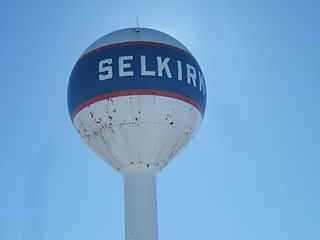
Selkirk is a city in the western Canadian province of Manitoba, located on the Red River about 22 kilometres (14 mi) northeast of Winnipeg, the provincial capital. It has a population of 10,504 as of the 2021 census.

<span class="mw-page-title-main">Morden, Manitoba</span> City in Manitoba, Canada

Morden is a city located in the Pembina Valley region of southern Manitoba, Canada near the United States border. It is about 11 km (6.8 mi) west of the neighbouring city of Winkler; together Morden and Winkler are often referred to as Manitoba's Twin Cities. Morden, which is surrounded by the Rural Municipality of Stanley, is the eighth largest and fastest-growing city in Manitoba. According to Statistics Canada, the city had a population of 9,929 in 2021, an increase of 14.5% from 2016, making it Manitoba's fastest growing city.

<span class="mw-page-title-main">Kildonan—St. Paul</span> Federal electoral district in Manitoba, Canada

Kildonan—St. Paul is a federal electoral district in the Winnipeg Capital Region of Manitoba, Canada. It has been represented in the House of Commons of Canada since 2004.

<span class="mw-page-title-main">Portage—Lisgar</span> Federal electoral district in Manitoba, Canada

Portage—Lisgar is a federal electoral district in Manitoba, Canada, that has been represented in the House of Commons of Canada since 1997.

<span class="mw-page-title-main">Winnipeg Metropolitan Region</span> Metropolitan area in Manitoba, Canada

The Winnipeg Metropolitan Region is a metropolitan area in the Canadian province of Manitoba located in the Red River Valley in the southeast portion of the province of Manitoba, Canada. It contains the provincial capital of Winnipeg and 17 surrounding rural municipalities, cities, and towns.

<span class="mw-page-title-main">Rural Municipality of Hanover</span> Rural municipality in Manitoba, Canada

The Rural Municipality of Hanover is a rural municipality (RM) in southeastern Manitoba, Canada, located southeast of Winnipeg in Division No. 2.

<span class="mw-page-title-main">Rural Municipality of St. Andrews</span> Rural municipality in Manitoba, Canada

St. Andrews is a rural municipality (RM) in Manitoba, Canada. It lies west of the Red River; its southern border is approximately 8 kilometres (5.0 mi) north of Winnipeg.

<span class="mw-page-title-main">Rural Municipality of St. Clements</span> Rural municipality in Manitoba, Canada

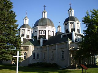
St. Clements is a rural municipality (RM) in Manitoba, Canada. It is located to the north-east of Winnipeg, stretching from East St. Paul and Birds Hill Provincial Park in the south to Lake Winnipeg and Grand Beach Provincial Park to the north. The Red River demarcates the western boundary of the municipality. St. Clements contains the communities of East Selkirk, and Lockport east of the Red River. It almost completely surrounds the Brokenhead 4 Indian reserve, with the exception of a small lakefront on Lake Winnipeg.

<span class="mw-page-title-main">Rural Municipality of Taché</span> Rural municipality in Manitoba, Canada

Taché is a rural municipality in Manitoba, Canada, incorporated in 1880.

<span class="mw-page-title-main">Rural Municipality of Springfield</span> Rural municipality in Manitoba, Canada

Springfield is a rural municipality (RM) in Manitoba, Canada. It stretches from urban industrial development on the eastern boundary of the city of Winnipeg, through urban, rural residential, agricultural and natural landscapes, to the Agassiz Provincial Forest on the municipality's eastern boundary. Birds Hill Provincial Park nestles into the north-western corner of Springfield.

<span class="mw-page-title-main">Rural Municipality of Ritchot</span> Rural municipality in Manitoba, Canada

The Rural Municipality of Ritchot is a rural municipality (RM) in the Winnipeg Capital Region, bordering the south side of Winnipeg in Manitoba, Canada. The separately-administered town of Niverville lies adjacent to its southeast, between it and the Rural Municipality of Hanover.

<span class="mw-page-title-main">Rural Municipality of Macdonald</span> Rural Municipality in Southern Manitoba

Macdonald is a rural municipality lying adjacent to the southwest side of Winnipeg, Manitoba, Canada. It is part of the Winnipeg Metro Region, but is not part of the smaller Winnipeg census metropolitan area. Macdonald's population as of the 2016 census was 7,162.

<span class="mw-page-title-main">Rural Municipality of Rockwood</span> Rural Municipality in Manitoba, Canada

Rockwood is a rural municipality (RM) lying north of Winnipeg, Manitoba, Canada. It is part of the Winnipeg Metro Region and had a 2021 census population of 8,440. The independently governed towns of Stonewall and Teulon are both enclaved within Rockwood.

<span class="mw-page-title-main">St. Adolphe, Manitoba</span> Place in Manitoba, Canada

St. Adolphe, or Saint Adolphe, originally called Pointe-Coupée, is a community in the Rural Municipality of Ritchot, Manitoba, Canada. It is located along the east bank of the Red River, approximately 12 kilometres south of Winnipeg.

<span class="mw-page-title-main">Demographics of Manitoba</span>

Manitoba is one of Canada's 10 provinces. It is the easternmost of the three Prairie provinces.

<span class="mw-page-title-main">Rural Municipality of Stanley</span> Rural municipality in Manitoba, Canada

Stanley is a rural municipality (RM) in the province of Manitoba in Western Canada. It is located in the southern part of the province, along its border with the state of North Dakota in the United States. Since 1876, the area made up part of the Mennonite West Reserve. The municipality has a population of 8,969 as of the 2016 Canada Census. The cities of Winkler and Morden lie geographically within the municipality but are separate urban municipalities.

According to the 2021 census, the City of Edmonton had a population of 1,010,899 residents, compared to 4,262,635 for all of Alberta, Canada. The total population of the Edmonton census metropolitan area (CMA) was 1,418,118, making it the sixth-largest CMA in Canada.

The demographics of Winnipeg reveal the city to be a typically Canadian one: multicultural and multilingual. Winnipeg is also prominent in the size and ratio of its First Nations population, which plays an important part in the city's makeup. About 12.4% of Winnipeggers are of Indigenous descent, which vastly exceeds the national average of 5.0%.

References

  1. "Elevation of Niverville". earthtools.org.
  2. "Census Profile, 2021 Census of Population, Town of Niverville". Statistics Canada. 9 February 2022. Retrieved February 9, 2022.
  3. "Census Profile, 2021". Statistics Canada. 9 February 2022. Retrieved February 12, 2022.
  4. Ernest Braun and Glen Klassen (2015). Historical Atlas of the East Reserve. Manitoba Mennonite Historical Society.
  5. "Reflections on our Heritage" (PDF). Derksen Printers Ltd. 1971. Retrieved 2016-10-03.
  6. "Niverville". The Canadian Encyclopedia. Retrieved February 19, 2022.
  7. "Grain Elevators". The Canadian Encyclopedia. Retrieved February 19, 2022.
  8. "Niverville Council Meetings in Review". Niverville Citizen. Retrieved February 19, 2022.
  9. Niverville Chamber of Commerce, "Niverville Area History".
  10. "Niverville Council Meetings in Review". Niverville Citizen. Retrieved February 19, 2022.
  11. "Population and dwelling counts, for Canada, provinces and territories, and census subdivisions (municipalities), 2016 and 2011 censuses – 100% data (Manitoba)". Statistics Canada. February 7, 2018. Retrieved January 29, 2022.
  12. "Winnipeg grows even as people flock to bedroom communities". Winnipeg Free Press. 9 February 2022. Retrieved February 19, 2022.
  13. "Population and dwelling counts: Canada, provinces and territories, and census subdivisions (municipalities), Manitoba". Statistics Canada. February 9, 2022. Retrieved February 20, 2022.
  14. Goldsborough, Gordon (February 11, 2022). "Manitoba Communities: Niverville (Town)". Manitoba Historical Society. Retrieved March 27, 2022.
  15. Government of Canada, Statistics Canada (2022-10-26). "Census Profile, 2021 Census of Population". www12.statcan.gc.ca. Retrieved 2023-06-10.
  16. Government of Canada, Statistics Canada (2021-10-27). "Census Profile, 2016 Census". www12.statcan.gc.ca. Retrieved 2023-06-10.
  17. Government of Canada, Statistics Canada (2015-11-27). "NHS Profile". www12.statcan.gc.ca. Retrieved 2023-06-10.
  18. Government of Canada, Statistics Canada (2019-08-20). "2006 Community Profiles". www12.statcan.gc.ca. Retrieved 2023-06-10.
  19. Government of Canada, Statistics Canada (2019-07-02). "2001 Community Profiles". www12.statcan.gc.ca. Retrieved 2023-06-10.
  20. "Niverville Economic Profile" (PDF). Government of Manitoba. Retrieved February 19, 2022.
  21. "Niverville Old Tyme Country Fair". Canadian Beats. Retrieved February 19, 2022.
  22. "Red River Cart at CRRC". Niverville Citizen. Retrieved February 20, 2022.
  23. "Heritage wall debuts in Niverville". The Carillon. 22 July 2021. Retrieved February 20, 2022.
  24. "Red River Cart at CRRC". Niverville Citizen. Retrieved February 20, 2022.
  25. "Niverville Mayor welcomes announcement". Steinbach Online. Retrieved February 19, 2022.
  26. "Provencher". Elections Canada. Retrieved February 19, 2022.
  27. "Governments celebrate upgrades to Niverville's water treatment plant". news.gov.mb.ca. June 9, 2012. Retrieved February 13, 2020.
  28. "Niverville joins list of communities restricting water use amid hot, dry weather". CTV News Winnipeg. June 8, 2017. Retrieved February 13, 2020.
  29. "Niverville - Urgent Water Notice". www.whereyoubelong.ca. June 7, 2017. Retrieved February 13, 2020.
  30. "The Niverville High School is Ready for Action". Steinbach Online. Retrieved February 19, 2022.
  31. Amanda Falk, "Amanda Falk's Myspace Page".