St. Lazare is an unincorporated community recognised as a local urban district in the Rural Municipality of Ellice – Archie within the Canadian province of Manitoba that held village status prior to January 1, 2015.
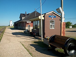
Rivers is an unincorporated urban community in the Riverdale Municipality within the Canadian province of Manitoba. It is located 40 kilometres (25 mi) northwest of Brandon, 473 metres (1,552 ft) above sea level. It is within the Westman Region. Agriculture, health and related businesses provide income for the community and area. Rivers has a population of 1,257 people in the 2016 census.
Binscarth is an unincorporated urban community in the Municipality of Russell – Binscarth, Manitoba. It is located approximately 167 km (104 mi) northwest of Brandon, 16 km (9.9 mi) south from Russell, and 16 km (10 mi) east of the Saskatchewan border.
Bowsman is an unincorporated urban community in the Municipality of Minitonas – Bowsman, Manitoba, Canada.

The Rural Municipality of Abernethy No. 186 is a rural municipality (RM) in the Canadian province of Saskatchewan within Census Division No. 6 and SARM Division No. 1. It is located on the Qu'Appelle River.
Pelly is a village in the Canadian province of Saskatchewan within the Rural Municipality of St. Philips No. 301 and Census Division No. 9.
Russell is an unincorporated urban community in the Municipality of Russell – Binscarth, Manitoba.
Powerview-Pine Falls is a town in the Canadian province of Manitoba, with a population of 1,314 at the 2011 census, up 1.54% from 1,294 at the 2006 census and down 7.57% from 1,400 during the 2001 census.
Minitonas is an unincorporated urban community in the Municipality of Minitonas – Bowsman, Manitoba, Canada. It is surrounded by the Swan Valley and is located 15 km east of the Town of Swan River. The community is close to the Duck Mountain Provincial Park.

Waskada is an unincorporated urban community in the Municipality of Brenda – Waskada within the Canadian province of Manitoba that held village status prior to January 1, 2015. It is located in the southwest corner of the province, close to the United States and Saskatchewan borders. It was settled as early as 1883 and incorporated as a village in 1948. Waskada has a population of 183, and covers a land area of 0.77 km2. Though traditionally a farming community, a recent oil boom has also brought economic activity to the area.

The Rural Municipality of North Qu'Appelle No. 187 is a rural municipality (RM) in the Canadian province of Saskatchewan within Census Division No. 6 and SARM Division No. 1. It is located in the south-east portion of the province.

Census Division No. 20 is a census division located within the Parkland Region of the province of Manitoba. Unlike in some other provinces, census divisions do not reflect the organization of local government in Manitoba. These areas exist solely for the purposes of statistical analysis and presentation; they have no government of their own.
The Municipality of Roblin is a rural municipality (RM) in the Parkland Region of Manitoba, Canada.
The Municipality of Lorne is a rural municipality (RM) in the Canadian province of Manitoba.
The Municipality of McCreary is a rural municipality (RM) in the Parkland Region of Manitoba, Canada.
The Municipality of Minitonas – Bowsman is a rural municipality (RM) in the Parkland Region of Manitoba, Canada. More precisely, it is located in the Swan Valley area.
The Municipality of Russell – Binscarth is a rural municipality (RM) in the Parkland Region of Manitoba, Canada. It is located in the far western part of the province and shares a border with the neighbouring province of Saskatchewan.

The Municipality of Swan Valley West (MSVW) is a rural municipality (RM) in the Parkland Region of Manitoba, Canada. It is located in the far western portion of Manitoba, along the provincial border with Saskatchewan.


