Duck Mountain Provincial Park (Manitoba)

Last updated

Duck Mountain Provincial Park
Toward baldy mountain.jpg
Toward Baldy Mountain.
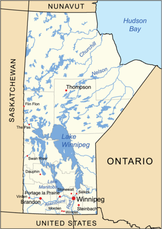
Canada Manitoba location map 2.svg
Red pog.svg
Location Division No. 20, Manitoba, Canada
Nearest town Swan River
Coordinates 51°39′58″N100°54′52″W / 51.66611°N 100.91444°W / 51.66611; -100.91444
Area1,424 km2 (550 sq mi)
Established1961
Governing bodyGovernment of Manitoba
At the entrance to Duck Mountain Park. Duck Mountain Park.jpg
At the entrance to Duck Mountain Park.

Duck Mountain Provincial Park is a 1,424 square kilometre [1] provincial park in western Manitoba. The park is located within the larger and similarly named Duck Mountain Provincial Forest. Duck Mountain Provincial Park was designated a provincial park by the Government of Manitoba in 1961. [2] and is considered to be a Class II protected area under the IUCN protected area management categories. [3] The park is unincorporated, not lying within the borders of any of Manitoba's rural municipalities.

Contents

The Duck Mountains are a rise of forested (formerly glaciated) land between the Saskatchewan prairie to the west and the Manitoba lowlands to the east. They are some 200m higher than the floor of the Assiniboine River valley to the west, and some 400m higher than the Manitoba lowlands. The highest point of the Duck Mountains is Baldy Mountain, which is also the highest point in Manitoba at 831 metres (2,726 ft) above mean sea level. [1]

Observation tower. Observation tower.jpg
Observation tower.

Geologically, the Duck Mountains are part of the Manitoba Escarpment, along with the Turtle Mountains, the Riding Mountains, and the Porcupine Hills. Their underlying rocks are Cretaceous shales and (below that) sandstone, which overlie deeper deposits of Devonian limestone, which in turn overlie Precambrian granite. [4] The vertical relief of the mountains is the result of erosion of the Cretaceous shale by the ancestral (pre Ice Age) Red River to the east, and by the ancestral Assiniboine River to the west, and so the Duck Mountain's apparent height is the result of a lowering of the surrounding prairie, rather than any orogen. Glacial scouring exaggerated the vertical relief of the mountains, and the glaciers deposited thick beds of glacial till that now overlay the bedrock. The post-ice age Duck Mountains then formed the western shore of Lake Agassiz. The flat bottom of Lake Agassiz now forms the Manitoba lowlands, and it is from these lowlands that the vertical relief of the Duck Mountains is most impressive (indeed, really the only place from which it is even readily noticeable), as the mountains provide an obvious contrast to the monotonous flat of Manitoba's prairie.

Singush Lake from Singush Lake Campground Singush Lake.JPG
Singush Lake from Singush Lake Campground

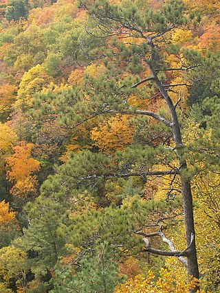
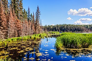
The area represents the southern limit of the boreal forest in its transition zone to aspen parkland. The forest soils are stony and the landscape is rolling, with numerous ponds and creek channels. The forest trees include white spruce, black spruce, tamarack larch, balsam fir, jack pine, quaking aspen, balsam poplar, and paper birch.

The flatter land areas surrounding the forest have almost entirely been converted to cereal-grain farmland, making the forest (and the contiguous Saskatchewan Duck Mountain Provincial Park) an environmental refuge for such large animals as elk, moose, black bear, lynx, bobcat, and timber wolf. The existence of a breeding population of cougars is suspected but unconfirmed. [5] It is likewise not known whether or not a breeding population of wolverines is present in the park, but the park is within that species' historical range. [6] The park is also within the historical range of grizzly bears, but they are no longer found in the area. Other animals, such as the white-tailed deer and coyote, are found in abundance in the park, but roam more freely into the surrounding agricultural lands and are thus less reliant on it.

Duck Mountain Provincial Park is contained wholly within a larger protected area called Duck Mountain Provincial Forest; however, neither the Provincial Park nor the Provincial Forest are completely protected from resource extraction industries such as logging and hunting.

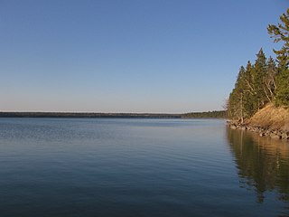
Child's Lake, East Blue Lake, Glad Lake, and Wellman Lake all have tourist facilities. These facilities may include boat launches, campgrounds, rental cottages, and privately owned vacation homes.

See also

Related Research Articles

<span class="mw-page-title-main">Swan River, Manitoba</span> Town in Manitoba, Canada

Swan River is a town in Manitoba, Canada. It is surrounded by the Municipality of Swan Valley West in the Swan River Valley region. According to the 2021 Canadian Census, Swan River had a population of 4,049, making it Manitoba's 18th largest in population.

<span class="mw-page-title-main">Aspen parkland</span> Temperate grasslands, savannas, and shrublands ecoregion of Canada and the United States

Aspen parkland refers to a very large area of transitional biome between prairie and boreal forest in two sections, namely the Peace River Country of northwestern Alberta crossing the border into British Columbia, and a much larger area stretching from central Alberta, all across central Saskatchewan to south central Manitoba and continuing into small parts of the US states of Minnesota and North Dakota. Aspen parkland consists of groves of aspen, poplar and spruce, interspersed with areas of prairie grasslands, also intersected by large stream and river valleys lined with aspen-spruce forests and dense shrubbery. This is the largest boreal-grassland transition zone in the world and is a zone of constant competition and tension as prairie and woodlands struggle to overtake each other within the parkland.

<span class="mw-page-title-main">Turtle Mountain Provincial Park</span> Provincial park in Manitoba, Canada

Turtle Mountain Provincial Park is a provincial park located in the southwestern portion of the Canadian province of Manitoba. Within it are the Adam Lake and Max Lake campgrounds. The park is known for its bike trails, fishing, back country cabins and canoe routes. The park is very popular with families and outdoor enthusiasts.

<span class="mw-page-title-main">Riding Mountain National Park</span> National park in Manitoba, Canada

Riding Mountain National Park is a national park in Manitoba, Canada. The park is located within Treaty 2 Territory and sits atop the Manitoba Escarpment. Consisting of a protected area 2,969 km2 (1,146 sq mi), the forested parkland stands in sharp contrast to the surrounding prairie farmland. It was designated a national park because it protects three different ecosystems that converge in the area; grasslands, upland boreal and eastern deciduous forests. It is most easily reached by Highway 10 which passes through the park. The south entrance is at the townsite of Wasagaming, which is the only commercial centre within the park boundaries.

Birds Hill Provincial Park is a provincial park in Manitoba, Canada located in the Boreal Plains ecozone. The park protects areas representative of Aspen/Oak parkland, as well as provides opportunities for recreation. It is located 24 kilometers north of Winnipeg on Highway 59, and covers approximately 8,300 acres or 35.1 km2.

<span class="mw-page-title-main">Parkland Region</span> Region of Manitoba in Canada

Parkland is an informal geographic region of the Canadian province of Manitoba, located between Lakes Manitoba and Winnipegosis on the east and the Manitoba–Saskatchewan border on the west.

<span class="mw-page-title-main">Geography of Manitoba</span>

The geography of Manitoba addresses the easternmost of the three prairie Canadian provinces, located in the longitudinal centre of Canada. Manitoba borders on Saskatchewan to the west, Ontario to the east, Nunavut to the north, and the American states of North Dakota and Minnesota to the south. Although the border with Saskatchewan appears straight on large-scale maps, it actually has many right-angle corners that give the appearance of a slanted line. In elevation, Manitoba ranges from sea level on Hudson Bay to 2727 ft (831 m) on top of Baldy Mountain. The northern sixty percent of the province is on the Canadian Shield. The northernmost regions of Manitoba lie permafrost, and a section of tundra bordering Hudson Bay.

<span class="mw-page-title-main">Pembina Escarpment</span>

The Pembina Escarpment is a scarp that runs from South Dakota to Manitoba, and forms the western wall of the Red River Valley. The height of the escarpment above the river valley is 300–400 feet (91–122 m).

The Manitoba Escarpment, or the Western Manitoba Uplands, are a range of hills along the Saskatchewan-Manitoba border. The eastern slopes of the range are considered to be a scarp. They were created by glacial scouring and formed the western shore of prehistoric Lake Agassiz.

<span class="mw-page-title-main">Duck Mountain Provincial Park (Saskatchewan)</span> Provincial park in Saskatchewan, Canada

Duck Mountain Provincial Park is a provincial park, located in the Canadian province of Saskatchewan 14 kilometres (8.7 mi) east of the town of Kamsack and stretches about 12 kilometres (7.5 mi) eastward to the Saskatchewan / Manitoba boundary. The park covers approximately 150 km2 (58 sq mi). Road access to the park is via Highway 57, which connects Saskatchewan Highway 5 to Manitoba Highway 83.

<span class="mw-page-title-main">Spruce Woods Provincial Park</span> Provincial park in Manitoba, Canada

Spruce Woods Provincial Park is located in south-central Manitoba, Canada where the Assiniboine River passes through the delta of sediment left by the last glaciation. An area of open and stabilized sand dunes within the park provides habitat to species of plants and animals not found elsewhere in Manitoba. In descending order of land area contained, the park lies within the Rural Municipalities of South Cypress, Victoria, and North Cypress.

<span class="mw-page-title-main">Boreal Plains Ecozone (CEC)</span> An ecozone

The Boreal Plains Ecozone, as defined by the Commission for Environmental Cooperation (CEC), is a terrestrial ecozone in the western Canadian provinces of Manitoba, Saskatchewan and Alberta. It also has minor extensions into northeastern British Columbia and south-central Northwest Territories. The region extends over 779,471 km2, of which 58,981 km2 is conserved.

The Porcupine Hills refer to various groups of hills and uplands located in the prairie provinces of Canada, specifically the provinces of Saskatchewan and Manitoba. They are part of the Manitoba Escarpment, which was the shoreline of the ancient glacial Lake Agassiz. The hills are located north-west of Swan River, Manitoba, and are the headwaters of the Swan River. The highest elevation in the Porcupine Hills is Hart Mountain, at an elevation of 823 metres (2,700 ft), which makes it Manitoba's second-highest point. The Porcupine Provincial Forest surrounds the area.

<span class="mw-page-title-main">Eastern forest–boreal transition</span> Temperate broadleaf and mixed forest ecoregion in Canada and the United States

The eastern forest–boreal transition is a temperate broadleaf and mixed forests ecoregion of North America, mostly in eastern Canada. It is a transitional zone or region between the predominantly coniferous Boreal Forest and the mostly deciduous broadleaf forest region further south.

<span class="mw-page-title-main">Eastern Great Lakes lowland forests</span> Temperate broadleaf and mixed forest ecoregion of Canada and the United States

The Eastern Great Lakes lowland forests is a temperate broadleaf and mixed forest ecoregion of North America, as defined by the World Wildlife Fund. It lies mostly in south and eastern Ontario and Quebec in Canada, and Upstate New York and Vermont in the United States.

<span class="mw-page-title-main">Mid-Continental Canadian forests</span> Taiga ecoregion of western Canada

The Mid-Continental Canadian forests are a taiga ecoregion of Western Canada, as defined by the World Wildlife Fund (WWF) categorization system.

<span class="mw-page-title-main">Western Great Lakes forests</span> Temperate broadleaf and mixed forest ecoregion in Canada and the United States

The Western Great Lakes forests is a terrestrial ecoregion as defined by the World Wildlife Fund. It is within the temperate broadleaf and mixed forests biome of North America. It is found in northern areas of the United States' states of Michigan, Wisconsin and Minnesota, and in southern areas of the Canadian province of Manitoba and northwestern areas of the province of Ontario.

<span class="mw-page-title-main">Forests of Canada</span>

The forests of Canada are located across much of the country. Approximately half of Canada is covered by forest, totaling around 2.4 million km2. Over 90% of Canada's forests are owned by the public. About half of the forests are allocated for logging.

Armit Meadows Ecological Reserve is an ecological reserve located in Porcupine Provincial Forest, Manitoba, Canada. It was established in 2015 under the Manitoba Ecological Reserves Act. It is 2.63 square kilometres (1.02 sq mi) in size.

Pasquia Hills are hills in the Canadian province of Saskatchewan. They are located in the east central part of the province in the RM of Hudson Bay No. 394 near the Manitoba border. The hills are the northern most in a series of hills called the Manitoba Escarpment. The Manitoba Escarpment marks the western edge of the pre-historical glacial Lake Agassiz. The other four hills include Porcupine Hills, Duck Mountain, and Riding Mountain.

References

  1. 1 2 "Duck Mountain Provincial Park". Find Your Favorite Park. Government of Manitoba. Archived from the original on 15 July 2017. Retrieved 1 July 2017.
  2. A System Plan for Manitoba's Provincial Park (PDF). Government of Manitoba. March 1997. p. 31. Archived from the original (PDF) on 15 July 2017. Retrieved 1 July 2017.
  3. "Duck Mountain Provincial Park". Protected Plant. United Nations Environment World Conservation Monitoring Centre. Retrieved 1 July 2017.
  4. "The Pembina Escarpment". Archived from the original on 19 June 2009. Retrieved 4 September 2009.
  5. "Cougars Confirmed in Manitoba" (PDF).[ permanent dead link ]
  6. "COSEWIC Assessment and Update Status Report on the Wolverine Gulo gulo" (PDF).