Central Park (Winnipeg)

Last updated
Central Park
Neighbourhood
Central Park, Winnipeg location on a map.png
Location of Central Park within Winnipeg
CountryFlag of Canada (Pantone).svg  Canada
Province Flag of Manitoba.svg  Manitoba
City Winnipeg
Area
  Land0.2 km2 (0.08 sq mi)
Population
 (2021)
  Total3,805
  Density16,221.9/km2 (42,015/sq mi)
Locations TypeLocation
• Neighbourhood ClusterDowntown East
• Community Area Downtown
• Police DistrictDistrict 1
• City Council WardDaniel McIntyre
[1]

Central Park is a large urban park located in downtown Winnipeg, and forms the heart of the neighbourhood of the same name.

Contents

The area is bound by Notre Dame Avenue to the north, Ellice Avenue to the south, Donald Street to the east and Balmoral Street to the west. Everything within the neighbourhood's one-kilometre loop can be reached within 8 minutes on foot. The neighbourhood is home to the largest concentration of Black Canadians in Manitoba, mostly African immigrants and refugees. [2] 70 percent of all refugees coming to Winnipeg live downtown, largely settling in and around the Central Park area. [3]

It is one of Winnipeg's most densely populated neighbourhoods with around 16,222 people per square km according to Statistics Canada's 2021 Census. [1]

Features

In addition to the Waddell Fountain, the park also features a four-season slide/toboggan facility, an interactive sand and water play area, an open area of artificial turf, and a wading pool and aquatic play pad. [4]

Culture and entertainment

Central Park is a highly diverse neighbourhood. There is a large Filipino, African, and Aboriginal population in the neighbourhood. [5]

Because of the growing African population, the area has been transforming in recent years, giving it a new sense of community and culture. Its Central Market for Global Families is a summer outdoor market that sells handmade and imported African clothing, beadwork, handicrafts, weavings, art, as well as organic produce.[ citation needed ]

Live entertainment fills the air in Central Park on warm Friday nights throughout the summer and are a significant aspect to the markets on Saturday. Special events attract hundreds of people to the park on World Refugee Day in June, HIV/AIDS Awareness Day in July and Central Park Revival.[ citation needed ]

Demographics

In 2021, the population of Central Park was 3,805 people, with a population density of 16,221.9 people per square km. Central Park is a lower-income neighbourhood, with a median household income of $34,800, compared to the city's median household income of $80,000. [1]

17.7% of Central Park residents were of Aboriginal Identity, 17.2% of Aboriginal Ancestry, and 66.2% were other visible minorities. The most represented of which were Black (37.7%) and Filipino (14.8%). As of 2021, 32.0% of Central Park's population were not Canadian citizens, which was above average for the City of Winnipeg as a whole, which was 13.9%. Central Park also boasted a higher percentage of recent immigrants (18.7%) than the city as a whole (6.0%). [1]

Crime

Central Park has a higher crime rate than the city as a whole. In 2012, there was one homicide making the rate per 100,000 residents 28.1. For other crimes, the rates per 100,000 follow as; 2025.3 for robbery, 84.4 for sexual assaults, 534.5 for break and enters and 281.3 for auto thefts. [6]

Architecture

Buildings around Central Park feature a diverse range of architectural styles and densities, coexisting with various shops and services. The YMCA building, Knox United Church, Calvary Temple, and a number of area schools provide a strong institutional component for families and senior citizens. Other landmark buildings are The International Centre, Welcome Place, and Edohei, considered to be Manitoba's first sushi restaurant.

History

Central Park was one of Winnipeg's first four parks, then referred to as "ornamented squares and breathing areas." The land for it was purchased by the city from the Hudson's Bay Company for $20,000 in 1893. [7] The land for the park was swampy in summer and had a significant amount of unusable ground. Thousands of loads of manure and soil were brought in, which caused subsequent settling, but also was responsible for lush lawns and gardens. [8]

A bandstand and two tennis courts were added to the park in 1905, and an iron fence and drinking fountain were added in 1909. The Waddell fountain was added to the park in 1914. Playground equipment was added in 1936 and restrooms in 1959. [8]

In 1985, the city closed off a section of Qu'Appelle Street, expanding the park to Ellice Avenue. The master plan was originally intended to link Central Park to the Manitoba Legislature grounds, but was abandoned at the development of North Portage and Portage Place mall from 1985 to 1987. [7] This addition brought the park up to 4.8 acres in size. [8]

The park was renovated between 2008 and 2012, with designs by the architecture firm Scatliff+Miller+Murray. [9] The project won the 2015 Premier's Award for Design Excellence Award of Merit in Landscape Architecture. [10]

Waddell Fountain

The Waddell Fountain in Central Park is a rare example of the High Victorian Gothic style in Manitoba, and is based on the Scott Monument, an 1844 Gothic Revival monument in Edinburgh for Romantic poet Sir Walter Scott. [8]

The fountain commemorates Emily Margaret Waddell, who died in 1908. [11] Her will was written in 1904 but only discovered in 1911. In it, Emily Waddell stipulated, "in case of his marrying again, ten thousand dollars is to be expended for public fountain in Central park, Winnipeg." [12] Thomas Waddell, who did remarry, raised the money in 1914 and chose the design by local architect John Manuel. [4] Manuel also designed structures at the University of Manitoba, and would later move to Alberta in 1927 to oversee construction of Canadian Pacific Railway hotels in Banff and Lake Louise. [13]

The fountain was completed by William Penn Stone Company of Minneapolis in 1914 for a cost of $9,722.19, and consisted of white stone on a granite base with a concrete basement to house the water pump. [8]

In 1988, the fountain was declared a historical site. By 1992, it was falling badly into disrepair. [14]

The fountain was dismantled and fixed offsite in 2010 to facilitate needed repairs. [4] The 2010 restoration project won the Heritage Winnipeg Preservation Award. [15]

Related Research Articles

<span class="mw-page-title-main">Winnipeg</span> Capital city of Manitoba, Canada

Winnipeg is the capital and largest city of the province of Manitoba in Canada. It is centred on the confluence of the Red and Assiniboine rivers, near the longitudinal centre of North America. As of 2021, Winnipeg had a city population of 749,607 and a metropolitan population of 834,678, making it Canada's sixth-largest city and eighth-largest metropolitan area.

<span class="mw-page-title-main">Saint Boniface, Winnipeg</span> Suburb in Winnipeg, Manitoba, Canada

St-Boniface is a city ward and neighbourhood in Winnipeg. Along with being the centre of the Franco-Manitoban community, it ranks as the largest francophone community in Western Canada.

<span class="mw-page-title-main">Charleswood, Winnipeg</span> Suburb of Winnipeg

Charleswood is a residential community and neighbourhood in Winnipeg, Manitoba, Canada. It is located in the South-West of the city and is bordered by the neighbourhoods Tuxedo to the East, Fort Whyte to the South, and the Rural Municipality of Headingley on the West. It's boundaries are Roblin and the Assiniboine River to the north, Shaftesbury Boulevard on the East, Wilkes Avenue to the South and the Perimeter Highway to the West.

<span class="mw-page-title-main">Tuxedo, Winnipeg</span> Suburb of Winnipeg, Canada

Tuxedo is a residential suburb of Winnipeg, Manitoba. It is located about 7 kilometres southwest of downtown Winnipeg and borders the Assiniboine River and Assiniboine Park on the north, Shaftesbury Boulevard on the west, Route 90 to the East and McGillvary Boulevard to the South. Prior to 1972, the community was incorporated as the Town of Tuxedo.

<span class="mw-page-title-main">Rural Municipality of Headingley</span> Rural municipality in Manitoba, Canada

Headingley is a rural municipality in Manitoba, Canada. It is located directly west of Winnipeg and had a population of 3,579 people as of the 2016 census.

Old Kildonan is the northernmost city ward of Winnipeg, Manitoba. Before the City of Winnipeg Act of 1972, it was an independent unincorporated municipality called the Municipality of Old Kildonan; prior to that, from 1914, it was a subdivision of the Rural Municipality of Kildonan.

St. Vital is a ward and neighbourhood of Winnipeg, Manitoba, Canada.

<span class="mw-page-title-main">Nassau Street (Winnipeg)</span> Street in Manitoba

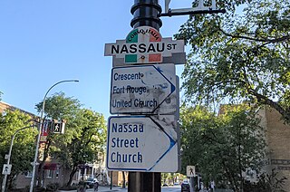
Nassau Street is a 2-kilometre (1.2 mi) street in Winnipeg, Manitoba, located partially within the Osborne Village and Fort Rouge neighbourhoods.

<span class="mw-page-title-main">Amalgamation of Winnipeg</span> Merger of the City of Winnipeg with other municipalities in 1972

The amalgamation of Winnipeg, Manitoba was the municipal incorporation of the old City of Winnipeg, eleven surrounding municipalities, and the Metropolitan Corporation of Greater Winnipeg (Metro) into one.

<span class="mw-page-title-main">St. James-Assiniboia, Winnipeg</span> Suburb in Winnipeg, Manitoba, Canada

St. James-Assiniboia is a major community area in Winnipeg, Manitoba, Canada. As it encapsulates most of the city ward of St. James, which includes the major St. James Street, the area itself is often simply referred to "St. James."

<span class="mw-page-title-main">Downtown Winnipeg</span> Neighbourhood in Winnipeg, Manitoba, Canada

Downtown Winnipeg is an area of Winnipeg located near the confluence of the Red and Assiniboine rivers. It is the oldest urban area in Winnipeg, and is home to the city's commercial core, city hall, the seat of Manitoba's provincial government, and a number of major attractions and institutions.

<span class="mw-page-title-main">The Forks, Winnipeg</span> Historic Meeting Place in Manitoba, Canada

The Forks is a historic site, meeting place, and green space in downtown Winnipeg located at the confluence of the Red River and the Assiniboine River.

<span class="mw-page-title-main">West End, Winnipeg</span> Urban area in Manitoba, Canada

The West End is a mostly residential area of Downtown Winnipeg, Manitoba, Canada. It includes the neighbourhoods of Armstrong's Point, Colony, Daniel McIntyre, Minto, Sargent Park, Spence, St. Matthews, West Broadway, and Wolseley.

<span class="mw-page-title-main">North End, Winnipeg</span> Neighbourhood in Winnipeg, Manitoba, Canada

Winnipeg's North End is a large urban area located to the north and northwest of Downtown Winnipeg. It is bordered by the Red River on the east, the Canadian Pacific Railway (CPR) mainline on the south, the City of Winnipeg boundary on the west and Jefferson Avenue, Keewatin Street, Carruthers Avenue, McGregor Street and the lane between McAdam and Smithfield Avenues on the north. It is the northern section of the City of Winnipeg as it existed prior to the 1972 municipal amalgamation. Winnipeg's northern suburbs such as West Kildonan and Old Kildonan are not considered part of the North End. The CPR mainline and its Winnipeg yards, which are one of the largest railway yards in the world, act as a physical barrier between the North End and the rest of Winnipeg to the south. This has resulted in the North End remaining a very distinct and unique part of Winnipeg.

The municipal government of Winnipeg is represented by 15 city councillors and a mayor elected every four years.

Marlton is one of the original neighbourhoods in the area of Charleswood in Winnipeg, Manitoba. It is bordered by Roblin Boulevard, bisects Tom Chester park to the east and Grant Avenue to the south.

The demographics of Winnipeg reveal the city to be a typically Canadian one: multicultural and multilingual. Winnipeg is also prominent in the size and ratio of its First Nations population, which plays an important part in the city's makeup. About 12.4% of Winnipeggers are of Indigenous descent, which vastly exceeds the national average of 5.0%.

David Paul Penner, MAA, FRAIC was a Canadian architect, born and raised in the Osborne Village neighbourhood of Winnipeg, Manitoba. He attended the University of Manitoba where he received his Bachelor of Environment Studies in 1979 and Masters of Architecture in 1985. Penner was the founding principal of David Penner Architect (DPA). He became a Fellow of the RAIC in 2012, and was involved in several organizations outside his firm including Storefront Manitoba and the Prairie Design Awards Program. His best-known architectural works include Fountain Springs Housing, Buhler Center, Windsor Park Library, and Mere Hotel. Penner died from a heart attack on January 7, 2020.

References

  1. 1 2 3 4 5 , Central Park 2021 Census. Retrieved January 29, 2024
  2. Garang, Reuben. "Integration and settlement: The experiences and expectations of African immigrants and refugees" (PDF). Retrieved 29 March 2019.
  3. Canadian Broadcasting Channel. "CBC Manitoba - Features - Urban Myths - Central Park". CBC News. Retrieved 2008-11-28.
  4. 1 2 3 "EXPLORE CENTRAL PARK!" (PDF). Winnipeg Architecture Foundation. Retrieved 2020-06-15.
  5. "2011 Census and National Household Survey Data Central Park" (PDF). City of Winnipeg. Retrieved 29 March 2019.
  6. "Winnipeg.ca : This page has moved".
  7. 1 2 Gruwel, Marieke (2019). "Landscape Tour of Central Park" (PDF). Winnipeg Architecture Foundation.
  8. 1 2 3 4 5 "WADDELL FOUNTAIN CENTRAL PARK" (PDF). City of Winnipeg. City of Winnipeg Historical Buildings Committee. April 1988. Retrieved 2020-06-16.
  9. "Central Park - Scatliff + Miller + Murray". www.scatliff.ca. Retrieved 2020-06-15.
  10. "Manitoba Association of Architects". www.mbarchitects.org. Retrieved 2020-06-15.
  11. "Obituaries". Winnipeg Tribune. 1908-01-27. Retrieved 2020-07-25.
  12. "$10,000 Park Fountain Cost Of Wedded Bliss". Winnipeg Tribune. 1938-06-18. Retrieved 2020-07-25.
  13. "Memorable Manitobans: John Manuel (1879-1933)". www.mhs.mb.ca. Retrieved 2020-06-16.
  14. Bridge, Bonnie (1992-01-28). "Officials debate water fountain's fate". Winnipeg Free Press. Retrieved 2020-07-25.
  15. "Manitoba Organization: Heritage Winnipeg". www.mhs.mb.ca. Retrieved 2020-06-16.

49°53′46″N97°08′55″W / 49.896°N 97.1485°W / 49.896; -97.1485