
Northern Manitoba is a geographic and cultural region of the Canadian province of Manitoba. Originally encompassing a small square around the Red River Colony, the province was extended north to the 60th parallel in 1912. The region's specific boundaries vary, as "northern" communities are considered to share certain social and geographic characteristics, regardless of latitude.
Birds Hill Provincial Park is a provincial park in Manitoba, Canada located in the Boreal Plains ecozone. The park protects areas representative of Aspen/Oak parkland, as well as provides opportunities for recreation. It is located 24 kilometers north of Winnipeg on Highway 59, and covers approximately 8,300 acres or 35.1 km2.
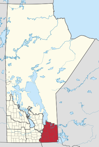
Eastern Manitoba, or the Eastman Region, is an informal geographic region of the Canadian province of Manitoba. It is bounded on the north by the Winnipeg River and Lake Winnipeg, on the east by the Manitoba-Ontario border, on the south by the Canada–US border, and on the west by the Red River.

Whiteshell Provincial Park is a provincial park in southeast Manitoba, approximately 120 kilometres (75 mi) east of the city of Winnipeg. The park is considered to be a Class II protected area under the IUCN protected area management categories. It is 275,210 hectares in size.

Nopiming Provincial Park is a natural provincial park in Manitoba, Canada, located on the southeast side of the province, along the boundary with Ontario.
Atikaki Provincial Park is a wilderness park in Manitoba, Canada, located east of Lake Winnipeg along the Ontario boundary in the Canadian Shield. The area of Atikaki Provincial Park is 3,981 square kilometres (1,537 sq mi). Atikaki Provincial Park is north of Nopiming Provincial Park and borders the Woodland Caribou Provincial Park in Ontario.
The Manigotagan River is a whitewater river located in southeastern Manitoba, Canada. The river flows into the eastern side of Lake Winnipeg and it is a rare remote river of southern Canada. Situated at the river's mouth, on the shore of Lake Winnipeg, is the community of Manigotagan.

The Sandilands Provincial Forest is a forest located within the southeastern area of Manitoba, Canada, and consists of thousands of acres of sand hills, forest, wetlands, and mostly unpopulated crown lands. Sandilands Provincial Forest covers close to 3,000 km2.

Duck Mountain Provincial Park is a 1,424 square kilometre provincial park in western Manitoba. The park is located within the larger and similarly named Duck Mountain Provincial Forest. Duck Mountain Provincial Park was designated a provincial park by the Government of Manitoba in 1961. and is considered to be a Class II protected area under the IUCN protected area management categories. The park is unincorporated, not lying within the borders of any of Manitoba's rural municipalities.

Beaudry Provincial Park is an approximately 953.4-hectare (2,356-acre) park located along the Assiniboine River west of the town of Headingley, Manitoba.

Pinawa Dam Provincial Park is a provincial park located north of Pinawa, Manitoba, on Hwy 520, overlooking the Pinawa Channel.
Birch Island Provincial Park is a remote provincial park located on Lake Winnipegosis in Manitoba, Canada. The park is bordered on its western boundary by the Swan-Pelican Provincial Forest and on its eastern side by Chitek Lake Anishinaabe Provincial Park.
Manigotagan River Provincial Park is a nature park in the province of Manitoba, Canada, named for the whitewater Manigotagan River that runs through it. Designated as a provincial park by the Government of Manitoba on 1 December 2004, it is the 80th provincial park in Manitoba. It is considered to be a Class II protected area under the IUCN protected area management categories.
River Road Provincial Park is a provincial park in the Canadian province of Manitoba, designated by the Government of Manitoba in 1997. The park is .05 square kilometres (0.019 sq mi) in size, and is considered to be a Class V protected area under the IUCN protected area management categories.
Rivers Provincial Park is a provincial park in the Canadian province of Manitoba, designated by the Government of Manitoba in 1961. The park is .86 square kilometres (0.33 sq mi) in size and is considered to be a Class III protected area under the IUCN protected area management categories.
Colvin Lake Provincial Park is a provincial park in Manitoba, Canada, designated by the Government of Manitoba in 2010. The park is 1,630 km2 (630 sq mi) in size. It is considered a Class Ib protected area under the International Union for Conservation of Nature (IUCN) protected-area management categories.

Brokenhead River Ecological Reserve is an ecological reserve on the Brokenhead River, Manitoba, Canada. It was established in 1978 under the Manitoba Crown Lands Act. It is 0.64 square kilometres (0.25 sq mi) in size. It is a reserve that protects 66 hectares of forest. The forest is home to a variety of trees such as the oak, spruce, and elm. The forest is home to animals as well, which include, the red fox, snapping turtle, beaver, and mink.
Cedar Bog Ecological Reserve is an ecological reserve located in Sandilands Provincial Forest, Manitoba, Canada. It was established in 2015 under the Manitoba Ecological Reserves Act. It is 1.1 square kilometres (0.42 sq mi) in size.
Whitemouth River Ecological Reserve is an ecological reserve located within the Sandilands Provincial Forest, Manitoba, Canada. It was established in 1986 under the Manitoba Ecological Reserves Act. It is 1.3 square kilometres (0.50 sq mi) in size.
Sturgeon Bay Provincial Park is a provincial park on the western shore of Lake Winnipeg in Manitoba, Canada. The park is considered to be a Class Ib protected area under the IUCN protected area management categories. It is 144.9 km2 (55.9 sq mi) in size.

