
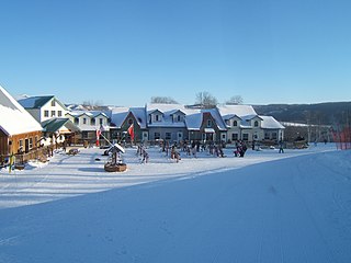
Canada has a large domestic and foreign tourism industry. The second largest country in the world, Canada's wide geographical variety is a significant tourist attractor. Much of the country's tourism is centred in the following regions: Toronto, Montreal, Quebec City, Vancouver/Whistler, Niagara Falls, Vancouver Island, Canadian Rockies, British Columbia's Okanagan Valley, Churchill, Manitoba and the National Capital Region of Ottawa-Gatineau. The large cities are known for their culture, diversity, as well as the many national parks and historic sites.
Asessippi Provincial Park is a provincial park in the Rural Municipality of Riding Mountain West, Manitoba, Canada.
Birds Hill Provincial Park is a provincial park in Manitoba, Canada located in the Boreal Plains ecozone. The park protects areas representative of Aspen/Oak parkland, as well as provides opportunities for recreation. It is located 24 kilometers north of Winnipeg on Highway 59, and covers approximately 8,300 acres or 35.1 km2.

Carberry is a town in southwestern Manitoba, Canada. It is situated 3 kilometres (1.9 mi) south of the Trans-Canada Highway on Highway 5 in the Municipality of North Cypress – Langford, and has a population of 1,818 people.

Whiteshell Provincial Park is a provincial park in southeast Manitoba, approximately 120 kilometres (75 mi) east of the city of Winnipeg. The park is considered to be a Class II protected area under the IUCN protected area management categories. It is 275,210 hectares in size.

Grand Beach Provincial Park is a provincial park in Manitoba, Canada, noted for its large white sand dunes and ancient beaches from the end of the last ice age. It is located on the eastern shore of Lake Winnipeg, one of the largest freshwater lakes in the world, and the largest lake completely within the borders of southern Canada.

Nopiming Provincial Park is a natural provincial park in Manitoba, Canada, located on the southeast side of the province, along the boundary with Ontario.

Mount Assiniboine Provincial Park is a provincial park in British Columbia, Canada, located around Mount Assiniboine.
Scouting in Manitoba has a long history, from the 1900s to the present day, serving thousands of youth in programs that suit the environment in which they live.
Provincial Trunk Highway 5 is a provincial primary highway located in the Canadian province of Manitoba.
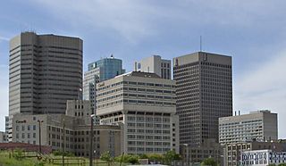
Southern Manitoba is the southernmost area of the Canadian province of Manitoba. Southern Manitoba encompasses the Winnipeg Metropolitan Region, Westman Region, Central Plains Region, Eastman Region, and Pembina Valley Region, as well as the Manitoba portion of Red River Valley. Holding a population of over one million, seven of the ten cities in Manitoba are located in this area, including Winnipeg, Brandon, Portage la Prairie, Selkirk, Morden, Winkler, and Steinbach.

Duck Mountain Provincial Park is a provincial park, located in the Canadian province of Saskatchewan 14 kilometres (8.7 mi) east of the town of Kamsack and stretches about 12 kilometres (7.5 mi) eastward to the Saskatchewan / Manitoba boundary. The park covers approximately 150 km2 (58 sq mi). Road access to the park is via Highway 57, which connects Saskatchewan Highway 5 to Manitoba Highway 83.

The Rural Municipality of North Cypress is a former rural municipality (RM) in the Canadian province of Manitoba. It was originally incorporated as a rural municipality on January 1, 1883. It ceased on January 1, 2015 as a result of its provincially mandated amalgamation with the RM of Langford to form the Municipality of North Cypress – Langford.
Touchwood Hills Post Provincial Park is the location of a former Hudson's Bay Company (HBC) fur trading post that existed from 1879 to 1909 in the Touchwood Uplands of the Canadian province of Saskatchewan. In 1986, the site was designated a provincial park. It is located along Highway 15 in the RM of Kellross No. 247, about 10 kilometres (6.2 mi) west of Lestock and 16 kilometres (9.9 mi) east of Punnichy.

Beaudry Provincial Park is an approximately 953.4-hectare (2,356-acre) park located along the Assiniboine River west of the town of Headingley, Manitoba.

The Midwestern Canadian Shield forests ecoregion, in the Taiga and Boreal forests Biome, are of northern Canada.
Fort des Épinettes was a trading post or posts on the Assiniboine River from 1768 to 1811. It was also called Pine Fort and is not to be confused with Pine Island Fort. It was the first post on the Assiniboine and was closely associated with Brandon House/Fort Assiniboine/Fort La Souris 18 miles to the west. For background see Assiniboine River fur trade.
Hubert Lake Wildland Provincial Park is a wildland provincial park in central Alberta, Canada. The park was established on 4 October 2000 and has an area of 9,665.46 hectares. The park is included in the Upper Athabasca Region Land Use Framework.
Douglas Provincial Park is a provincial park in the Canadian province of Saskatchewan. Established in 1973, it is named after Tommy Douglas, the seventh premier of Saskatchewan and father of Canada's first single-payer, universal health care programme. The park is located along the Gordon McKenzie Arm of Lake Diefenbaker and at the Qu'Appelle River Dam, which is the source of the Qu'Appelle River. The closest community is Elbow and access to the park is from Highway 19.
Fort Assiniboine Sandhills Wildland Provincial Park is a wildland provincial park in Woodlands County, Alberta, Canada. The park is 7,903 hectares in area and was established in 1997. The park is contained in the Upper Athabasca Land Use Framework. The park is managed through the Fort Assiniboine Sandhills Wildland Provincial Park Management Plan. The Klondike Trail passes through the western section of the park for about five kilometres (3 mi). This trail was first established in 1824–1825 as a portage between Fort Edmonton on the North Saskatchewan River and Fort Assiniboine on the Athabasca River. The portage was part of the York Factory Express, a 19th-century fur brigade route of the Hudson's Bay Company from Fort Vancouver on the Columbia River to York Factory on Hudson Bay. The trail was revived again during the Klondike Gold Rush in 1897–1899 as part of the overland route to the Klondike gold fields near Dawson City, Yukon. Today, the section of the Klondike Trail within the park extends north of the Klondike Trail Staging Area and includes the ruins of a trapper's cabin and the gravesite of a child who died during trek.


