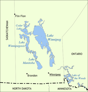
Lake Winnipeg is a very large, relatively shallow 24,514-square-kilometre (9,465 sq mi) lake in North America, in the province of Manitoba, Canada. Its southern end is about 55 kilometres (34 mi) north of the city of Winnipeg. Lake Winnipeg is Canada's sixth-largest freshwater lake and the third-largest freshwater lake contained entirely within Canada, but it is relatively shallow excluding a narrow 36 m (118 ft) deep channel between the northern and southern basins. It is the eleventh-largest freshwater lake on Earth. The lake's east side has pristine boreal forests and rivers that were in 2018 inscribed as Pimachiowin Aki, a UNESCO World Heritage Site. The lake is 416 km (258 mi) from north to south, with remote sandy beaches, large limestone cliffs, and many bat caves in some areas. Manitoba Hydro uses the lake as one of the largest reservoirs in the world. There are many islands, most of them undeveloped.

The Rural Municipality of Gimli is a rural municipality located in the Interlake Region of south-central Manitoba, Canada, on the western shore of Lake Winnipeg. It is about 75 kilometres (47 mi) north of the provincial capital Winnipeg. The rural municipality's population in the 2016 Canadian Census was 6,181, making it the 12th largest rural municipality by population. The RM of Gimli has an area of 318.75 square kilometres (123.07 sq mi), making it the sixth smallest rural municipality by area.
The Rural Municipality of Bifrost is a former rural municipality (RM) in the Canadian province of Manitoba. It was originally incorporated as a rural municipality on December 1, 1907. It ceased on January 1, 2015 as a result of its provincially mandated amalgamation with the Village of Riverton to form the Municipality of Bifrost – Riverton.

The Boreal Shield Ecozone, as defined by the Commission for Environmental Cooperation (CEC), is the largest ecozone in Canada. Covering 1.8 million square kilometres it covers almost 20% of Canada's landmass, stretching from northern Saskatchewan to Newfoundland.

The geography of Manitoba addresses the easternmost of the three prairie Canadian provinces, located in the longitudinal centre of Canada. Manitoba borders on Saskatchewan to the west, Ontario to the east, Nunavut to the north, and the American states of North Dakota and Minnesota to the south. Although the border with Saskatchewan appears straight on large-scale maps, it actually has many right-angle corners that give the appearance of a slanted line. In elevation, Manitoba ranges from sea level on Hudson Bay to 2727 ft (831 m) on top of Baldy Mountain. The northern sixty percent of the province is on the Canadian Shield. The northernmost regions of Manitoba lie permafrost, and a section of tundra bordering Hudson Bay.

The Pembina Escarpment is a scarp that runs from South Dakota to Manitoba, and forms the western wall of the Red River Valley. The height of the escarpment above the river valley is 300–400 feet (91–122 m).
Hnausa which roughly translates to "uneven ground" is a small community located in the area known as New Iceland in Manitoba's Interlake Region. It is 6 miles, or approximately 10 kilometres, south of Riverton, and is situated on Breidavik on the coast of Lake Winnipeg, in the Rural Municipality of Bifrost. The settlement was founded in the area by 35 Icelandic families in 1876. Hnausa Post Office was set up in 1889 in the home of Rev. Magnus J. Skaptason. Much of the population descended from these immigrants from Iceland.

The Boreal Plains Ecozone, as defined by the Commission for Environmental Cooperation (CEC), is a terrestrial ecozone in the western Canadian provinces of Manitoba, Saskatchewan and Alberta. It also has minor extensions into northeastern British Columbia and south-central Northwest Territories. The region extends over 779,471 km2, of which 58,981 km2 is conserved.

Beaudry Provincial Park is an approximately 953.4-hectare (2,356-acre) park located along the Assiniboine River west of the town of Headingley, Manitoba.
Birch Island Provincial Park is a remote provincial park located on Lake Winnipegosis in Manitoba, Canada. The park is bordered on its western boundary by the Swan-Pelican Provincial Forest and on its eastern side by Chitek Lake Anishinaabe Provincial Park.
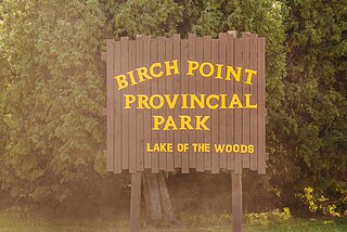
Birch Point Provincial Park is a provincial park located on Buffalo Bay, Lake of the Woods in Manitoba, Canada., about 160 kilometres (99 mi) southeast of Winnipeg. It is 13.1 hectares (0.051 sq mi) in size. It was designated as a Provincial Park in 1961.
Basket Lake Wildlife Management Area (WMA) is a provincially designated protected area in Manitoba. It is located north of Lake Manitoba and west of Hwy 6. It was designated under the Manitoba Wildlife Act by the Government of Manitoba in 1974. It is 7,260 hectares (28.0 sq mi) in size. The WMA is named after 'Basket Lake', a shallow lake surrounded by marsh, located in its southern portion.
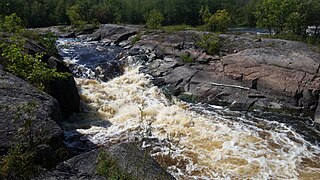
Whitemouth Falls Provincial Park is a provincial park located where the Whitemouth River joins the Winnipeg River in Manitoba, Canada. It was designated as a Provincial Park in 1974.

Camp Morton Provincial Park is a provincial park located on the west shore of Lake Winnipeg in Manitoba, Canada, about 6 kilometres (3.7 mi) north of Gimli. It is 250.23 hectares (0.9661 sq mi) in size. It was designated as a provincial park in 1974.

Bakers Narrows Provincial Park is a provincial park south of Flin Flon in the Northern Region of Manitoba, Canada. It is 145 hectares (0.56 sq mi) in size. It was designated as a provincial park in 1961.
Bell Lake Provincial Park is a provincial park on the north shore of Bell Lake in the Porcupine Provincial Forest, Manitoba, Canada. It is 4 hectares in size. It was designated as a provincial park in 1974.
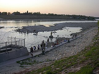
Lockport Provincial Park is a Manitoba provincial park on the east shore of the Red River in the community of Lockport, Manitoba. It is 2.26 ha in size.
Manipogo Provincial Park is a provincial park on the shore of Lake Manitoba, approximately 50 km (31 mi), northeast of Dauphin, Manitoba. It is named after Manipogo, a lake monster reputed to live in the lake.

Netley Creek Provincial Park is a Manitoba provincial park on the west shore of the Red River north of Selkirk, Manitoba at the mouth of Netley Creek. It provides visitors with access to these waterways and adjacent Netley-Libau Marsh.
Sturgeon Bay Provincial Park is a provincial park on the western shore of Lake Winnipeg in Manitoba, Canada. The park is considered to be a Class Ib protected area under the IUCN protected area management categories. It is 144.9 km2 (55.9 sq mi) in size.
