Interlake Region

Last updated
Interlake Region
Interlake Region MB map 2021.png
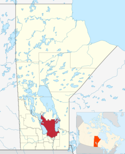
Map of the Interlake Region of Manitoba.
Country Flag of Canada (Pantone).svg Canada
Province Flag of Manitoba.svg Manitoba
Area
  Total15,858.13 km2 (6,122.86 sq mi)
Population
 (2021) [1]
  Total98,028
  Density6.2/km2 (16/sq mi)

The Interlake Region is an informal geographic region of the Canadian province of Manitoba that lies roughly between Lake Winnipeg and Lake Manitoba in the Canadian province of Manitoba.

Contents

The region comprises 14 rural municipalities, one city (the City of Selkirk), five towns (Arborg, Riverton, Stonewall, Teulon and Winnipeg Beach) ,and one village (Dunnottar). The largest population centre in the region is Selkirk, and the second largest is the town of Stonewall.

Argyle, Manitoba, is the small hamlet that is located on the Principal Meridian of Canada, near the middle of the Interlake Region. Sandy Hook is located between Winnipeg Beach and Gimli, a popular summer vacation spot.

Geography

The Interlake Region geographically is a low lying glacial lake basin that is poorly drained. [2] The area is clearly defined on the west by the shores of Lake Manitoba and on the eastern edge by Lake Winnipeg. The northern and southern boundaries are less clearly defined geographically. The geography of the region is mostly composed of sandy beaches, wetlands, lakes, bogs, marshlands, agricultural fields, glacial till, rocky shorelines, and oak, aspen, and eastern cedar forests. [2] The topography is mostly level and poorly drained, swamps exist in all portions of the region. [3] The soils are mostly shallow and mixed with lime and thus mostly infertile. [3] Agricultural areas do thrive in the regions surrounding the Icelandic River basin in the north around Arborg and Riverton, as well as in the area east of Teulon and close to Gimli.

Climate

The climate of the area is moderated by the lakes and overall is slightly cooler than the weather found in Winnipeg and southern Manitoba.

Climate data for Arborg (1981–2010 normals)
MonthJanFebMarAprMayJunJulAugSepOctNovDecYear
Record high °C (°F)7.5
(45.5)
7.8
(46.0)
16.7
(62.1)
30.0
(86.0)
37.0
(98.6)
37.0
(98.6)
36.5
(97.7)
36.1
(97.0)
36.5
(97.7)
28.5
(83.3)
20.6
(69.1)
9.5
(49.1)
37.0
(98.6)
Average high °C (°F)−12.6
(9.3)
−8.9
(16.0)
−1.8
(28.8)
9.1
(48.4)
16.9
(62.4)
21.9
(71.4)
24.8
(76.6)
24.0
(75.2)
17.5
(63.5)
9.1
(48.4)
−1.6
(29.1)
−9.9
(14.2)
7.4
(45.3)
Daily mean °C (°F)−18.3
(−0.9)
−14.9
(5.2)
−7.5
(18.5)
3.0
(37.4)
10.0
(50.0)
15.8
(60.4)
18.6
(65.5)
17.5
(63.5)
11.5
(52.7)
3.9
(39.0)
−6.0
(21.2)
−14.8
(5.4)
1.6
(34.9)
Average low °C (°F)−23.9
(−11.0)
−20.8
(−5.4)
−13.3
(8.1)
−3.2
(26.2)
3.2
(37.8)
9.6
(49.3)
12.3
(54.1)
10.9
(51.6)
5.4
(41.7)
−1.3
(29.7)
−10.3
(13.5)
−19.7
(−3.5)
−4.3
(24.3)
Record low °C (°F)−45.6
(−50.1)
−48.3
(−54.9)
−42.2
(−44.0)
−29.5
(−21.1)
−14.0
(6.8)
−5.0
(23.0)
1.1
(34.0)
−2.0
(28.4)
−7.8
(18.0)
−21.0
(−5.8)
−40.0
(−40.0)
−41.1
(−42.0)
−48.3
(−54.9)
Average precipitation mm (inches)16.9
(0.67)
12.4
(0.49)
24.9
(0.98)
25.9
(1.02)
55.4
(2.18)
80.9
(3.19)
70.3
(2.77)
68.9
(2.71)
53.4
(2.10)
43.9
(1.73)
27.0
(1.06)
19.7
(0.78)
499.4
(19.66)
Average snowfall cm (inches)16.9
(6.7)
10.1
(4.0)
15.3
(6.0)
7.8
(3.1)
1.2
(0.5)
0.0
(0.0)
0.0
(0.0)
0.0
(0.0)
0.4
(0.2)
6.9
(2.7)
18.3
(7.2)
18.7
(7.4)
95.6
(37.6)
Source: Environment Canada [4]
Climate data for Gimli, Manitoba
MonthJanFebMarAprMayJunJulAugSepOctNovDecYear
Record high °C (°F)8.2
(46.8)
8.1
(46.6)
15.0
(59.0)
29.2
(84.6)
36.1
(97.0)
36.7
(98.1)
35.0
(95.0)
37.5
(99.5)
36.5
(97.7)
26.1
(79.0)
22.8
(73.0)
6.3
(43.3)
37.5
(99.5)
Average high °C (°F)−12.8
(9.0)
−9.3
(15.3)
−1.8
(28.8)
8.2
(46.8)
16.3
(61.3)
21.6
(70.9)
24.9
(76.8)
23.2
(73.8)
16.9
(62.4)
9.5
(49.1)
−1.1
(30.0)
−10.5
(13.1)
7.1
(44.8)
Daily mean °C (°F)−18.2
(−0.8)
−14.8
(5.4)
−7.3
(18.9)
2.7
(36.9)
10.6
(51.1)
16.1
(61.0)
19.2
(66.6)
17.5
(63.5)
11.6
(52.9)
4.8
(40.6)
−5.2
(22.6)
−15.4
(4.3)
1.8
(35.2)
Average low °C (°F)−23.5
(−10.3)
−20.3
(−4.5)
−12.8
(9.0)
−2.9
(26.8)
4.7
(40.5)
10.5
(50.9)
13.5
(56.3)
11.8
(53.2)
6.3
(43.3)
0.0
(32.0)
−9.2
(15.4)
−20.3
(−4.5)
−3.5
(25.7)
Record low °C (°F)−41.2
(−42.2)
−39.4
(−38.9)
−34.4
(−29.9)
−25.6
(−14.1)
−9.5
(14.9)
−1.3
(29.7)
2.8
(37.0)
0.5
(32.9)
−15.8
(3.6)
−16.4
(2.5)
−34.3
(−29.7)
−39.4
(−38.9)
−41.2
(−42.2)
Average precipitation mm (inches)22.2
(0.87)
17.3
(0.68)
30.0
(1.18)
30.0
(1.18)
49.8
(1.96)
94.1
(3.70)
69.7
(2.74)
64.2
(2.53)
66.7
(2.63)
38.3
(1.51)
27.6
(1.09)
22.5
(0.89)
532.5
(20.96)
Average rainfall mm (inches)0.3
(0.01)
0.3
(0.01)
8.8
(0.35)
19.8
(0.78)
47.6
(1.87)
94.1
(3.70)
69.7
(2.74)
64.2
(2.53)
65.6
(2.58)
30.3
(1.19)
5.3
(0.21)
1.8
(0.07)
407.8
(16.06)
Average snowfall cm (inches)27.6
(10.9)
21.7
(8.5)
24.1
(9.5)
11.4
(4.5)
2.2
(0.9)
0
(0)
0
(0)
0
(0)
1.1
(0.4)
8.4
(3.3)
26.6
(10.5)
25.0
(9.8)
148.1
(58.3)
Average precipitation days (≥ 0.2 mm)12.39.29.58.19.912.711.711.611.110.09.412.4127.6
Average rainy days (≥ 0.2 mm)0.300.352.55.69.512.711.711.610.98.22.30.5376.1
Average snowy days (≥ 0.2 cm)13.99.78.53.71.00.05000.452.68.613.662.0
Mean monthly sunshine hours 119.3141.2190.3247.5284.4289.6319.1271.8174.8141.194.9102.42,376.4
Source: Environment Canada [5]

Demographics

Major communities

Name of Population CentrePopulation (2021)
Arborg 1,279
Ashern 616
Eriksdale 846
Fisher Branch 465
Gimli 2,345
Riverton 475
Selkirk 10,504
Stonewall 5,046
Teulon 1,201
Winnipeg Beach 1,145

Census subdivisions

The Interlake Economic Region is made of three subdivisions according to Statistics Canada which includes Divisions No. 13, No. 14, and No. 18.

Division No.Population (2021)Area Km2
No. 1351,6431,662.28
No. 1419,7492,833.41
No. 1826,63611,362.44
Totals98,02815,858.13

See also

Related Research Articles

<span class="mw-page-title-main">Lakeside (electoral district)</span> Provincial electoral district in Manitoba, Canada

Lakeside is a provincial electoral division in Manitoba, Canada. It is located to the immediate northwest of the city of Winnipeg.

<span class="mw-page-title-main">Interlake</span> Defunct provincial electoral district in Manitoba, Canada

Interlake was a provincial electoral division in the Canadian province of Manitoba. It was created by redistribution in 1979, and has formally existed since the 1981 provincial election. Previously, much of the Interlake region was included in the constituency of St. George. As its name implies, Interlake was located between Lake Winnipeg and Lake Manitoba, in the mid-northern section of the province.

<span class="mw-page-title-main">Gimli (electoral district)</span> Defunct provincial electoral district in Manitoba, Canada

Gimli was a provincial electoral division in the Canadian province of Manitoba. It was created by redistribution in 1899, and existed continuously until the 2019 election. Following this, it was redistributed into the Interlake-Gimli electoral district.

<span class="mw-page-title-main">Selkirk—Interlake—Eastman</span> Federal electoral district in Manitoba, Canada

Selkirk—Interlake—Eastman is a federal electoral district in Manitoba, Canada, that has been represented in the House of Commons of Canada from 1976 to 1987, and since 1997.

<span class="mw-page-title-main">Winnipeg Metropolitan Region</span> Metropolitan area in Manitoba, Canada

The Winnipeg Metropolitan Region is a metropolitan area in the Canadian province of Manitoba located in the Red River Valley in the southeast portion of the province of Manitoba, Canada. It contains the provincial capital of Winnipeg and 17 surrounding rural municipalities, cities, and towns.

The Rural Municipality of Bifrost is a former rural municipality (RM) in the Canadian province of Manitoba. It was originally incorporated as a rural municipality on December 1, 1907. It ceased on January 1, 2015 as a result of its provincially mandated amalgamation with the Village of Riverton to form the Municipality of Bifrost – Riverton.

<span class="mw-page-title-main">Area codes 204, 431, and 584</span> Telephone area codes for Manitoba

Area codes 204, 431, and 584 are telephone area codes in the North American Numbering Plan (NANP) for the Canadian province of Manitoba. Area code 204 is one of the nine original North American area codes assigned to Canada in 1947. Area codes 431 and 584 were assigned to the same numbering plan area (NPA) in 2012 and 2022, respectively, forming an overlay complex.

<span class="mw-page-title-main">Winnipeg Beach</span> Town in Manitoba, Canada

Winnipeg Beach is a town in the Interlake Region, in the Canadian province of Manitoba. The town was founded in 1900 by Sir William Whyte and is located at the junction of Highway 9 and Highway 229 on the southwestern shore of Lake Winnipeg, about 56 kilometres (35 mi) north of Winnipeg. It is bordered by the Rural Municipality of Gimli, the Rural Municipality of St. Andrews, and Dunnottar as well as Lake Winnipeg. Nearby towns are Ponemah, Whytewold, and Matlock, Gimli, and Sandy Hook,, as well as Teulon, and Selkirk. Its permanent population is 1,439

<span class="mw-page-title-main">Stonewall, Manitoba</span> Town in Manitoba, Canada

Stonewall is a town in the Canadian province of Manitoba with a population of 5,046 as of the 2021 census. The town is situated approximately 25 kilometres (16 mi) north of Winnipeg on PTH 67. It is known for its limestone quarries. The local festival is the Quarry Days which is usually held over three days in August on Main Street. The town is surrounded by the R.M. of Rockwood.

<span class="mw-page-title-main">Teulon</span> Town in Manitoba, Canada

Teulon is a town located approximately 59 kilometres north of Winnipeg, Manitoba, Canada, on Provincial Trunk Highway 7. Located between Stonewall and Gimli, Teulon is commonly referred to as "The Gateway to the Interlake". Teulon is surrounded by the Rural Municipality of Rockwood.

<span class="mw-page-title-main">Division No. 14, Manitoba</span> Census division in Manitoba, Canada

Census Division No. 14 is a census division located within the Interlake Region of the province of Manitoba, Canada. Unlike in some other provinces, census divisions do not reflect the organization of local government in Manitoba. These areas exist solely for the purposes of statistical analysis and presentation; they have no government of their own.

<span class="mw-page-title-main">Division No. 18, Manitoba</span> Census division in Manitoba, Canada

Census Division No. 18 is a census division located within the Interlake Region of the province of Manitoba, Canada. Unlike in some other provinces, census divisions do not reflect the organization of local government in Manitoba. These areas exist solely for the purposes of statistical analysis and presentation; they have no government of their own.

Eriksdale is an unincorporated community located in the Interlake Region of central Manitoba, Canada, near the eastern shore of Lake Manitoba. The community is located on the crossroads of Highway 6 and Highway 68, approximately 118 km (73 mi) north of Winnipeg. It is now a part of the Rural Municipality of West Interlake.

<span class="mw-page-title-main">Gimli, Manitoba</span> Community in Manitoba, Canada

Gimli is an unincorporated community in the Rural Municipality of Gimli on the west side of Lake Winnipeg in Manitoba, Canada.

Interlake-Eastern Regional Health Authority is the governing body responsible for healthcare delivery and regulation for the Interlake and eastern regions of Manitoba.

<span class="mw-page-title-main">Municipality of Bifrost – Riverton</span> Rural municipality in Manitoba, Canada

The Municipality of Bifrost – Riverton is a rural municipality (RM) in the Canadian province of Manitoba. The rural municipality is located in the Interlake Region has no further rural municipalities north of it as this is the Northern Manitoba Region. To the west is the Rural Municipality of Fisher and the Rural Municipality of Armstrong is located to the south as well as the Rural Municipality of Gimli. The settlement of Arborg is located in Bifrost – Riverton but is not a part of the rural municipality as it is incorporated as a town.

Hnausa Beach Provincial Park is a provincial park in Manitoba, Canada, on the west shore of Lake Winnipeg north of Gimli, Manitoba. The beach within the park is named after the nearby community of Hnausa. Hnausa is an Old Icelandic word for a piece of turf. This part of Manitoba is known as New Iceland due to the significant Icelandic settlement of the area that began in 1875.

<span class="mw-page-title-main">Icelandic River</span> River in Manitoba, Canada

The Icelandic River is a river in the Interlake Region of Manitoba. The river has its headwaters near the Spruce Lakes system located by Manitoba Highway 68. The river is the source of an agricultural area in the north of the Interlake, flowing through and supporting the communities of Arborg, Manitoba and Riverton, Manitoba. The East Interlake Conservation Area has assessed that 81% of the land use of the Icelandic River watershed is used for an agricultural purpose. The river's mouth is located at Riverton where the water flows into Lake Winnipeg. The Icelandic River is one of the most important spawning sites on the western shores of Lake Winnipeg for fish such as walleye, though recreation and agricultural activities have inhibited this capability recently.

References

References

  1. "Interlake economic region statistics". Statistics Canada . Retrieved March 24, 2023.
  2. 1 2 "Interlake Region Manitoba Canada". Eh Canada Travel. Retrieved March 24, 2023.
  3. 1 2 James Morton Richtik (October 1964). "A Historical Geography of the Interlake Area of Manitoba from 1871-1921". University of Manitoba . Retrieved March 24, 2023.
  4. "Canadian Climate Normals 1981-2010". Environment Canada . Retrieved 13 June 2018.
  5. "Canadian Climate Normals 1971–2000". Environment Canada. Retrieved March 19, 2012.

50°50′N97°40′W / 50.833°N 97.667°W / 50.833; -97.667