Beausejour, Manitoba

Last updated

Beausejour
Town of Beausejour
Beausejour MB.jpg
Aerial view with Beausejour in the centre foreground
401 Beausejour, Manitoba.svg
Town boundaries
Canada Manitoba location map 2.svg
Red pog.svg
Beausejour
Location of Beausejour in Manitoba
Coordinates: 50°03′44″N96°30′58″W / 50.06222°N 96.51611°W / 50.06222; -96.51611
CountryCanada
Province Manitoba
Region Eastman
Rural Municipality Brokenhead
Established1874
Incorporated1908 (village)
1912 (town)
Government
  MayorRay Schrile
  Governing Body Town Council
   MP (Selkirk-Interlake-Eastman) James Bezan (CPC)
   MLA
(Lac du Bonnet)
Wayne Ewasko (PC)
Area
  Total5.35 km2 (2.07 sq mi)
Elevation
251.2 m (824 ft)
Population
 (2021)
  Total3,307
  Density584.4/km2 (1,514/sq mi)
Time zone UTC-6 (CST)
  Summer (DST) UTC-5 (CDT)
Area code(s) Area codes 204 and 431
Website www.townofbeausejour.ca OOjs UI icon edit-ltr-progressive.svg

Beausejour ( /ˌbzəˈʒʊər/ ) [1] is a town in the Canadian province of Manitoba. It is 46 kilometres northeast of Winnipeg, just west of the Canadian Shield and Whiteshell Provincial Park. The French name Beauséjour [beau + séjour] means "beautiful stay". The town is surrounded by the Rural Municipality of Brokenhead.

Contents

Etymology

The current community name comes from the French phrase meaning "a good place" or "a good stopping place". [2] [3] There are a few variations as to the origin and establishment of the name, although all share similarities in being named by a railway employee. [3] One version is that a French Canadian National Railway engineer, after slashing through brush and swamp, came to this high and grassy place. [3]

A second documented version from S. Turner, the town's postmaster in 1905 says that he believed the town name came from a French Canadian government engineer. The railway station was built on a small, elevated area of sand and gravel, which had been called "Stony Prairie" by local Indigenous peoples. The engineer provided the name as it was a good camping ground from the other low lying areas. [3]

A third and final version says that the town`s first residents, Mr. and Mrs. H.W.D. Armstrong were the ones to name the town. Mr. H.W.D. Armstrong was a Canadian Pacific Railway surveyor who was responsible for the selection of names along this line and asked his wife to name it. She suggested the Beausejour name for "a nice play to stay". [3]

History

In 1906, the "Manitoba Glass Works" was founded, in a town now known as Beausejour, by Joseph Keilback and his partners. Sustained by a nearby deposit of high quality sand, it was the first glass container factory in Western Canada. Glassblowers from Poland and the United States, supported by local labour, used silica sands to produce bottles for breweries and soft drink companies in Winnipeg. In 1909 it was taken over by a Winnipeg businessman, who expanded production to include jars, medicine bottles, and ink bottles. At its peak, the Manitoba Glass Works employed 350 workers, but because of its inability to compete with Eastern Canadian manufacturers, was purchased in 1913 by a Montreal company and relocated to Redcliff, Alberta. The factory site remains, and was designated as a Provincial Heritage Site (number 41) on 27 September 1989. [4]

In 1912, the Town of Beausejour was incorporated. [5]

It is the birthplace of former Provincial Premier and Governor General Edward Schreyer. [6] Edward Schreyer School is named after him in his honour.

Beausejour was the setting for the 1990 film The Outside Chance of Maximilian Glick , & its 1990-91 television dramedy series adaptation, Max Glick . The film was largely filmed there.

Demographics

Historical population
YearPop.±%
1911847    
1921994+17.4%
19311,139+14.6%
19411,161+1.9%
19511,376+18.5%
19611,770+28.6%
1996 2,712+53.2%
2001 2,772+2.2%
2006 2,823+1.8%
2011 3,126+10.7%
2016 3,219+3.0%
2021 3,307+2.7%
[7] [8] [9] [10]

In the 2021 Census of Population conducted by Statistics Canada, Beausejour had a population of 3,307 living in 1,483 of its 1,572 total private dwellings, a change of

Access

Major highways servicing Beausejour are PTH 44 and PTH 12, which run concurrently north of town. From the south, Beausejour can be reached by traveling PTH 12 and Provincial Road 215 east into town or by taking PR 302. PTH 44, PR 215, and PR 302 intersect at the west side of town.

Prior to the construction of the Trans-Canada Highway, PTH 44 was the main route from Winnipeg to the Ontario border.

Economy

Beausejour's current economy is based on agriculture (grain production) and tourism. [5] Its location as a main access point to the Whiteshell Provincial Park, a popular cottage region and tourist attraction, allows Beausejour to cater to visitor traffic through the area. It also serves as the main commercial centre for farmers and residents of the surrounding areas.

Notable people

Recreation

The town is home to the Canadian Power Toboggan Championships, the Double B Agricultural Festival (formerly Double B Rodeo and Country Fair) and the annual Brokenhead River Agricultural Conference. Beausejour is also known for its annual "Shades of the Past" car show on the last Sunday of August. The car show encompasses all of Park Avenue and attracts over 500 classic and special interest vehicles.

Beausejour has also hosted the 2011 Manitoba provincial men's curling championship (then known as the Safeway Championship) won by Jeff Stoughton (Charleswood), and two Manitoba provincial women's curling championships, Scott Tournament of Hearts, at the Sun Gro Centre. The 2004 Manitoba Scott Tournament of Hearts was won by Lois Fowler (Brandon, Wheat City Curling Club), while the 2016 Scotties Tournament of Hearts was won by Kerri Einarson (East St. Paul Curling Club), with Beausejour's Selena Kaatz playing third.

Sports

Beausejour hosted the 2006 Power Smart Manitoba Games. The opening ceremonies were held at the CPTC Racetrack, and the closing ceremonies at the Sun Gro Centre.

Beausejour's hockey teams are known as the Blades. Beausejour's CRJHL team is the Beausejour Comets. The Eastman Selects of the Manitoba Midget 'AAA' Hockey League plays in the town. Hockey games are played in the Sun Gro Centre, which also has a curling rink. [11]

Media

The Beausejour Review published its final issue on 27 June 2013. [12]

There are two local weekly community newspapers serving the Beausejour and Brokenhead area.

The Clipper Weekly and The Lac du Bonnet Clipper. The Clipper Publishing Corp.

Town Radio Beausejour broadcasts to Beausejour and the surrounding area as CKBJ-FM at 93.9 on the FM dial.

Climate

Beausejour has a humid continental climate influenced by its far inland position in the higher mid-latitudes, resulting in warm and occasionally hot summers and frequently severely cold winters, with January average highs being below −11 °C (12 °F).

Climate data for Beausejour (1981–2010 normals)
MonthJanFebMarAprMayJunJulAugSepOctNovDecYear
Record high °C (°F)7.0
(44.6)
10.5
(50.9)
18.5
(65.3)
34.0
(93.2)
37.0
(98.6)
38.0
(100.4)
36.7
(98.1)
39.0
(102.2)
38.0
(100.4)
29.4
(84.9)
22.2
(72.0)
8.5
(47.3)
39.0
(102.2)
Mean daily maximum °C (°F)−11.3
(11.7)
−7.0
(19.4)
−0.3
(31.5)
10.5
(50.9)
18.4
(65.1)
23.1
(73.6)
25.6
(78.1)
25.2
(77.4)
18.5
(65.3)
10.2
(50.4)
−0.4
(31.3)
−9.1
(15.6)
8.6
(47.5)
Daily mean °C (°F)−16.9
(1.6)
−12.8
(9.0)
−5.7
(21.7)
4.2
(39.6)
11.4
(52.5)
16.7
(62.1)
19.3
(66.7)
18.5
(65.3)
12.5
(54.5)
5.0
(41.0)
−4.8
(23.4)
−14.1
(6.6)
2.8
(37.0)
Mean daily minimum °C (°F)−22.4
(−8.3)
−18.5
(−1.3)
−11.2
(11.8)
−2.2
(28.0)
4.3
(39.7)
10.2
(50.4)
12.9
(55.2)
11.6
(52.9)
6.4
(43.5)
−0.3
(31.5)
−9.1
(15.6)
−19.1
(−2.4)
−3.1
(26.4)
Record low °C (°F)−44.5
(−48.1)
−46.7
(−52.1)
−42.2
(−44.0)
−30.6
(−23.1)
−13.9
(7.0)
−4.4
(24.1)
0.0
(32.0)
−2.5
(27.5)
−8.3
(17.1)
−23.0
(−9.4)
−39.5
(−39.1)
−42.5
(−44.5)
−46.7
(−52.1)
Average precipitation mm (inches)24.6
(0.97)
15.5
(0.61)
23.4
(0.92)
29.7
(1.17)
58.1
(2.29)
87.5
(3.44)
87.1
(3.43)
76.3
(3.00)
65.1
(2.56)
46.0
(1.81)
29.7
(1.17)
27.2
(1.07)
570.3
(22.45)
Average snowfall cm (inches)24.3
(9.6)
13.1
(5.2)
14.2
(5.6)
9.0
(3.5)
3.1
(1.2)
0.0
(0.0)
0.0
(0.0)
0.0
(0.0)
0.0
(0.0)
7.5
(3.0)
21.2
(8.3)
25.5
(10.0)
117.8
(46.4)
Source: Environment Canada [13]

Related Research Articles

<span class="mw-page-title-main">Dauphin, Manitoba</span> City in Manitoba, Canada

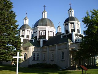
Dauphin is a city in Manitoba, Canada, with a population of 8,368 as of the 2021 Canadian Census. The community is surrounded by the Rural Municipality of Dauphin. The city takes its name from Lake Dauphin and Fort Dauphin, which were named by explorer Pierre Gaultier de La Vérendrye in honour of the Dauphin of France, the heir to the French throne. Dauphin is Manitoba's ninth largest community and serves as a hub to the province's Parkland Region.

Fred Theodore Klym was a politician in Manitoba, Canada. He was a Progressive Conservative member of the Legislative Assembly of Manitoba from 1959 to 1969.

Arthur A. "Archie" Trapp was a politician in Manitoba, Canada. He served in the Legislative Assembly of Manitoba as a Liberal-Progressive from 1958 to 1959.

<span class="mw-page-title-main">Rural Municipality of Hanover</span> Rural municipality in Manitoba, Canada

The Rural Municipality of Hanover is a rural municipality (RM) in southeastern Manitoba, Canada, located southeast of Winnipeg in Division No. 2.

<span class="mw-page-title-main">Pinawa</span> Local government district in Manitoba, Canada

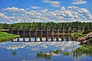
Pinawa is a local government district and small community of 1,331 residents located in southeastern Manitoba, Canada. It is 110 kilometres north-east of Winnipeg. The town is situated on the Canadian Shield within the western boundary of Whiteshell Provincial Park, which lies near the Manitoba-Ontario provincial boundary. Administratively, the town includes the surrounding area, and is officially the Local Government District of Pinawa. Except for a small eastern border with the unorganized area of the Eastman Region, it is surrounded by the Rural Municipalities of Lac du Bonnet to the north and Whitemouth to the south, but is independent of either one. The community lies on the north bank of the Winnipeg River in the southeastern part of the Local Government District.

Provincial Trunk Highway 6 is a provincial primary highway located in the Canadian province of Manitoba. It runs from the Perimeter Highway of Winnipeg to the Thompson south city limits. It is also the main highway connecting Winnipeg to northern Manitoba. The speed limit is 100 km/h. The route is also used to deliver nickel from the Thompson mine to the Royal Canadian Mint in Winnipeg. The section of highway between its southern terminus near Winnipeg and the second junction with PTH 68 near Eriksdale is part of the Northern Woods and Water Route. The portion of the highway between Ponton and Thompson was known as Highway 391 prior to 1986.

Provincial Trunk Highway 15 is a provincial highway in the Canadian province of Manitoba. It runs from Winnipeg's Perimeter Highway east to Elma where it ends at PTH 11. PTH 15 and the portion of Route 115 east of PTH 59 are collectively known as Dugald Road.

<span class="mw-page-title-main">Rivers, Manitoba</span> Unincorporated community in Manitoba, Canada

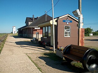
Rivers is an unincorporated urban community in the Riverdale Municipality within the Canadian province of Manitoba. It is located 40 kilometres (25 mi) northwest of Brandon, 473 metres (1,552 ft) above sea level. It is within the Westman Region. Agriculture, health and related businesses provide income for the community and area. Rivers has a population of 1,257 people in the 2016 census.

Provincial Trunk Highway 11 is a provincial primary highway located in the Eastman Region of the Canadian province of Manitoba. It runs from an intersection with PTH 59 near Victoria Beach to an intersection with PTH 1.

<span class="mw-page-title-main">Whiteshell Provincial Park</span> Provincial park in Manitoba, Canada

Whiteshell Provincial Park is a provincial park in southeast Manitoba, approximately 120 kilometres (75 mi) east of the city of Winnipeg. The park is considered to be a Class II protected area under the IUCN protected area management categories. It is 275,210 hectares in size.

<span class="mw-page-title-main">Whiteshell River</span> River in Ontario, Manitoba

The Whiteshell River is one of the major rivers in Whiteshell Provincial Park, in southeastern Manitoba, Canada, near the Ontario border. This river is close to some petroform sites that are about 2000 years old or older. The name "whiteshell" is in reference to the Meegis or cowry shells used by Ojibwa peoples in their ceremonies and teachings, especially the Midewiwin, and as recorded in their birch bark scrolls.

<span class="mw-page-title-main">Elma, Manitoba</span> Place in Manitoba, Canada

Elma, Manitoba, is an unincorporated community of approximately 100 people in southeast Manitoba. It is located on the Whitemouth River, at the junction of Highway 15 and Highway 11 in the Rural Municipality of Whitemouth.

<span class="mw-page-title-main">Manitoba Highway 12</span> Highway in Manitoba

Provincial Trunk Highway 12 is a provincial primary highway located in the Canadian province of Manitoba. Lying entirely in the Eastman Region, it runs from the U.S. border to a dead end in Grand Beach. PTH 12 forms the Manitoba section of MOM's Way, a tourist route from Thunder Bay to Winnipeg. PTH 12 is primarily a two-lane highway except for two four-lane stretch between Steinbach and PTH 1 and a ten-kilometre concurrency with PTH 44.

Provincial Trunk Highway 44 is an east-west provincial highway in the Eastman Region of the Canadian province of Manitoba.

Brokenhead Ojibway Nation is an Anishinaabe (Saulteaux/Ojibwa) First Nation located approximately 64 kilometres (40 mi) northeast of Winnipeg, Manitoba.

<span class="mw-page-title-main">Rural Municipality of Brokenhead</span> Rural municipality in Manitoba, Canada

The Rural Municipality of Brokenhead is a rural municipality (RM) in the Canadian province of Manitoba.

The Sun Gro Centre is a multi-purpose recreation complex located in the town of Beausejour, Manitoba. The complex features a 1,100 seat ice hockey arena, a curling club, an outdoor pool, and an indoor walking track.

<span class="mw-page-title-main">Brokenhead River</span> River in Manitoba, Canada

The Brokenhead River is a river in eastern Manitoba, Canada. It flows north from its source in the Brokenhead Swamp within Sandilands Provincial Forest, to its mouth in Lake Winnipeg south of Stoney Point.

<span class="mw-page-title-main">Manitoba Provincial Road 215</span>

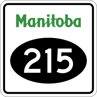
Provincial Road 215 is a short provincial road in the Canadian province of Manitoba.

The La Vérendrye Trail is a series of highways in the Canadian province of Manitoba commemorating the oldest waterway fur-trading route in the province. It is named after Pierre Gaultier de Varennes, sieur de La Vérendrye, an explorer and fur-trader who is often credited as being the first European to visit what is now southern Manitoba.

References

  1. The Canadian Press (2017), The Canadian Press Stylebook (18th ed.), Toronto, The Canadian Press {{citation}}: CS1 maint: location missing publisher (link)
  2. "Manitoba Communities: Beausejour (Town)". Manitoba Historical Society . Retrieved 1 February 2024.
  3. 1 2 3 4 5 Geographical Names of Manitoba (PDF). Government of Manitoba. 2002. p. 67. Retrieved 1 February 2024.
  4. Manitoba Provincial Heritage Sites
  5. 1 2 http://www.townofbeausejour.ca
  6. "ED Schreyer". University of Manitoba. Archived from the original on 8 October 2012. Retrieved 22 July 2010.
  7. http://www66.statcan.gc.ca/eng/acyb_c1932-eng.aspx?opt=/eng/1932/193201410103_p.%20103.pdf , Censuses 1871-1931
  8. "Canada Year Book 1955" (PDF). Archived from the original (PDF) on 9 December 2013. Retrieved 2014-08-30., Census 1941-1951
  9. "Canada Year Book 1967" (PDF). Archived from the original (PDF) on 23 December 2014. Retrieved 2014-08-30., Census 1961
  10. 1 2 "Population and dwelling counts: Canada, provinces and territories, and census subdivisions (municipalities), Manitoba". Statistics Canada. 9 February 2022. Retrieved 20 February 2022.
  11. Sun Gro Centre
  12. Paul, Alexandra (26 June 2013). "Lac du Bonnet, Beausejour papers to cease publication". Winnipeg Free Press. Retrieved 4 July 2013.
  13. "Canadian Climate Normals 1981-2010". Environment Canada. 25 September 2013. Retrieved 10 June 2018.