Birds Hill Provincial Park

Last updated
Birds Hill Provincial Park
BirdsHillParkpano.jpg
Birds Hill Park, overlooking lake
Canada Manitoba location map 2.svg
Red pog.svg
LocationManitoba, Canada
Nearest cityWinnipeg, Manitoba
Coordinates 50°01′28″N96°53′01″W / 50.02444°N 96.88361°W / 50.02444; -96.88361 Coordinates: 50°01′28″N96°53′01″W / 50.02444°N 96.88361°W / 50.02444; -96.88361
Area35.1 km2 (13.6 sq mi)
DesignationProvincial Park
Established1964
Governing bodyGovernment of Manitoba
Birds Hill Provincial Park

Birds Hill Provincial Park is a provincial park in Manitoba, Canada located in the Boreal Plains ecozone. [1] The park protects areas representative of Aspen/Oak parkland, as well as provides opportunities for recreation. [2] It is located 24 kilometers north of Winnipeg on Highway 59, and covers approximately 8,300 acres (3,400 hectares) or 35.1 km2 (13.6 square miles). [3]

Contents

Birds Hill Provincial Park was designated a provincial park by the Government of Manitoba in 1964. [3] The park is considered to be a Class III protected area under the IUCN protected area management categories. [4]

Description

Picnic area beside lake at Birds Hill Provincial Park . BirdsHillParkpicnic.jpg
Picnic area beside lake at Birds Hill Provincial Park .

Birds Hill Provincial Park is a popular destination, receiving more than a million visitors annually. In summer, festivals and sporting events are held, the main campground is heavily booked, and families enjoy the beach and picnic areas. In winter, trails are groomed for cross-country skiing, skijoring and kick-sledding and the riding stable offers horse-drawn sleigh rides. [2]

More than half of the park is set aside as backcountry, offering visitors trails for hiking, cross-country skiing, horseback riding and mountain biking. Almost 40% of the park is classified for recreational development use, including the campgrounds, the beach and picnic sites, the scenic roadways, the riding stable and other equestrian facilities, the festival site and the pioneer homesteads. [2]

Three scenic roadways were added when the park was developed, North Drive, South Drive and Festival Drive. The paved shoulders of these roads are frequently used for walking, running, roller sports, and cycling. [2]

Birds Hill Provincial Park is located within the Rural Municipalities of Springfield and St. Clements; the official boundary between the two municipalities runs through the park. [2]

Geology

The park rises in a series of six low rounded hills. Those in the south and west stand 20 m (66 ft) above the surrounding land while those in the north and east are more than 40 metres (130 ft) higher. [5] A lookout tower has been built on Griffiths Hill at about the halfway point of the Chickadee hiking trail. [6]

The park's landscape today is still defined by the events of 11,000 to 12,000 years ago as a Pleistocene glacier retreated and melted into glacial Lake Agassiz. [5] [7] Initially the glacier melt water deposited sand and gravel in a complex of eskers. [5] [7] As the glacier continued to retreat, Lake Agassiz submerged the eskers adding silt and clay around them. [7] At the edge of the huge lake, spits and beaches formed and eroded as the lake slowly dropped. [5] Five major strandlines of this glacial lake can be found within the park boundaries. [7]

The rock layers beneath Birds Hill Park are consistent with those in the surrounding region. Deepest of all are those of the Precambrian Superior Craton, the volcano-plutonic rocks of the Bird River subprovince. [7] The older rocks are overlaid by Paleozoic layers—the dolomitic limestone and dolomite of the Red River Formation on top of the shale and sandstone of the Winnipeg Formation. [7] These two sedimentary layers contain aquifers important to neighbouring communities, including Winnipeg. [7] [8] The glacial and post glacial deposits lying directly on the sedimentary layers within the park allow precipitation to recharge the aquifer beneath. [8]

Ecology

Cedar bog self-guiding trail winds through an aspen forest in the park to descend into a bog of eastern white cedar. Cedar Bogs are uncommon in Manitoba. Cedarbogtrail.JPG
Cedar bog self-guiding trail winds through an aspen forest in the park to descend into a bog of eastern white cedar. Cedar Bogs are uncommon in Manitoba.

Trembling aspen and bur oak forest is the dominant plant community found in the park. Prairie species are found in drier upland sites. Wetlands in the park include marshes, black spruce/tamarack bogs and a cedar bog. Other trees found within the park include Manitoba maple, jack pine, paper birch, white spruce, and balsam poplar . [9] [10]

Birds Hill Park is home to over 40 mammal species including White-tailed deer. [11]

Over two hundred species of birds have been found within the park boundaries. These include Northern goshawk, Northern shrike, Boreal chickadee, Red-breasted nuthatch, American woodcock, Northern saw-whet owl, Sprague's pipit, Indigo bunting, Eastern towhee, and Lark sparrow. [12]

Western Silvery Aster, a species protected under federal and provincial Endangered Species laws has been found growing in the park. [11]

History

Since the area is higher than the surrounding terrain, what is now Birds Hill Park served early settlers as a refuge from flooding in the years 1826 and 1852. [9]

Between 1895 and 1899, the settlers of Pine Ridge built a Lutheran church on land then owned by John Uhrich, now within the park. The church closed in 1920 and its building was removed to another site, and later demolished. [13] The church graveyard, Pine Ridge Cemetery, is located near Nimowin Road. Many early settlers of the area are buried there. [14]

The park was formed from land expropriated from more than 150 local landowners in 1964. [15] The official opening date was marked by a ribbon cutting ceremony by Manitoba premier Duff Roblin on July 15, 1967. [16] [15]

The park is named in honour of Dr. Curtis Bird, first speaker of the Manitoba provincial legislature in 1873, whose father had been a factor in the Hudson's Bay Company and received a large land grant at this location. [9]

Events

Equestrian and cycling events for the 1967 Pan American Games hosted by Winnipeg were held in the park. [17]

Winnipeg Folk Festival, Main Stage, 2006. Winnipeg Folk Festival 2006 (0092).jpg
Winnipeg Folk Festival, Main Stage, 2006.

Every July since 1974, the park has been the site of the Winnipeg Folk Festival. [17]

September 16, 1984, Pope John Paul II celebrated mass at the park during his visit to Manitoba. [9] [17] [18]

On August 29, 1992, Bryan Adams performed at the Waking Up the Nation Festival held at the park with the Deadbeat Honeymooners, Extreme, Sass Jordan and Steve Miller. [19]

The park hosted the 1998 Canadian Triathlon Championships. [20]

The park was the location of the road cycling, triathlon, and equestrian competitions during the 1999 Pan American Games. [20]

In 2017, the park was the venue for the triathlon, road cycling and open-water swimming events for the Canada Games. [20]

See also

Related Research Articles

<span class="mw-page-title-main">Lake Winnipeg</span> Large glacial lake in Manitoba, Canada

Lake Winnipeg is a very large, relatively shallow 24,514-square-kilometre (9,465 sq mi) lake in North America, in the province of Manitoba, Canada. Its southern end is about 55 kilometres (34 mi) north of the city of Winnipeg. Lake Winnipeg is Canada's sixth-largest freshwater lake and the third-largest freshwater lake contained entirely within Canada, but it is relatively shallow excluding a narrow 36 m (118 ft) deep channel between the northern and southern basins. It is the eleventh-largest freshwater lake on Earth. The lake's east side has pristine boreal forests and rivers that were in 2018 inscribed as Pimachiowin Aki, a UNESCO World Heritage Site. The lake is 416 km (258 mi) from north to south, with remote sandy beaches, large limestone cliffs, and many bat caves in some areas. Manitoba Hydro uses the lake as one of the largest reservoirs in the world. There are many islands, most of them undeveloped.

<span class="mw-page-title-main">Dugald, Manitoba</span> Unincorporated community in Manitoba, Canada

Dugald is a community in Manitoba, Canada, located 22 kilometres east of Winnipeg at the junction of PTH 15 and Provincial Road 206 in the Rural Municipality of Springfield. It was the site of a railway accident in 1947.

<span class="mw-page-title-main">Turtle Mountain Provincial Park</span> Provincial park in Manitoba, Canada

Turtle Mountain Provincial Park is a provincial park located in the southwestern portion of the Canadian province of Manitoba. Within it are the Adam Lake and Max Lake campgrounds. The park is known for its bike trails, fishing, back country cabins and canoe routes. The park is very popular with families and outdoor enthusiasts.

<span class="mw-page-title-main">Oakbank, Manitoba</span> Unincorporated community in Manitoba, Canada

Oakbank is an unincorporated community in Manitoba, Canada located about 15 km east of the provincial capital Winnipeg, in the Rural Municipality of Springfield.

<span class="mw-page-title-main">Asessippi Provincial Park</span> Provincial park in Manitoba, Canada

Asessippi Provincial Park is a provincial park in the Rural Municipality of Riding Mountain West, Manitoba, Canada.

<span class="mw-page-title-main">Rural Municipality of East St. Paul</span> A suburb of Winnipeg, Canada

East St. Paul is a rural municipality (RM) in Manitoba, Canada. It is located north-east of and adjacent to the city of Winnipeg, and is part of the Winnipeg Metropolitan Area. The municipality was formed on 3 November 1915 when the municipality of St. Paul (1888-1914) was subdivided into West St. Paul and East St. Paul, with the Red River acting as the dividing line.

<span class="mw-page-title-main">Birds Hill</span> Unincorporated municipality in East St. Paul

Birds Hill is an unincorporated community in the Canadian province of Manitoba located a few kilometers northeast of Winnipeg, Manitoba, in the Rural Municipality of East St. Paul. The community is a few kilometers east of the Red River The R.M. of East St. Paul's Administration and Finance Departments, Fire Department, municipal council chambers, and RCMP offices are located in Birds Hill. The community includes Silverfox Estates and the Country Villas, which is Manitoba's first resort age-restricted adult-only gated community. Built in 1998, this residential area is an exclusively low-density community where 163 detached, single-family homes are on private landscaped sites.

<span class="mw-page-title-main">Whiteshell Provincial Park</span> Provincial park in Manitoba, Canada

Whiteshell Provincial Park is a provincial park in southeast Manitoba, approximately 120 kilometres (75 mi) east of the city of Winnipeg. The park is considered to be a Class II protected area under the IUCN protected area management categories. It is 275,210 hectares in size.

<span class="mw-page-title-main">Grand Beach Provincial Park</span> Provincial park in Manitoba, Canada

Grand Beach Provincial Park is a provincial park in Manitoba, Canada, noted for its large white sand dunes and ancient beaches from the end of the last ice age. It is located on the eastern shore of Lake Winnipeg, one of the largest freshwater lakes in the world, and the largest lake completely within the borders of southern Canada.

<span class="mw-page-title-main">Nopiming Provincial Park</span> Provincial park in Manitoba, Canada

Nopiming Provincial Park is a natural provincial park in Manitoba, Canada, located on the southeast side of the province, along the boundary with Ontario.

<span class="mw-page-title-main">Rural Municipality of Springfield</span> Rural municipality in Manitoba, Canada

Springfield is a rural municipality (RM) in Manitoba, Canada. It stretches from urban industrial development on the eastern boundary of the City of Winnipeg, through urban, rural residential, agricultural and natural landscapes, to the Agassiz Provincial Forest on the municipality's eastern boundary. Birds Hill Provincial Park nestles into the north-western corner of Springfield.

<span class="mw-page-title-main">Southern Manitoba</span> Geographic region in Manitoba, Canada

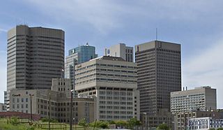
Southern Manitoba is the southernmost area of the Canadian province of Manitoba. Southern Manitoba encompasses the Winnipeg Metropolitan Region, Westman Region, Central Plains Region, Eastman Region, and Pembina Valley Region, as well as the Manitoba portion of Red River Valley. Holding a population of over one million, seven of the ten cities in Manitoba are located in this area, including Winnipeg, Brandon, Portage la Prairie, Selkirk, Morden, Winkler, and Steinbach.

<span class="mw-page-title-main">Spruce Woods Provincial Park</span> Provincial park in Manitoba, Canada

Spruce Woods Provincial Park is located in south-central Manitoba, Canada where the Assiniboine River passes through the delta of sediment left by the last glaciation. An area of open and stabilized sand dunes within the park provides habitat to species of plants and animals not found elsewhere in Manitoba. In descending order of land area contained, the park lies within the Rural Municipalities of South Cypress, Victoria, and North Cypress.

<span class="mw-page-title-main">Beaudry Provincial Park</span> Provincial park in Manitoba, Canada

Beaudry Provincial Park is an approximately 953.4-hectare (2,356-acre) park located along the Assiniboine River west of the town of Headingley, Manitoba.

Provincial Road 206 is a provincial road in Manitoba, Canada, located in the Rural Municipalities of Springfield, Taché, and Hanover.

Birch Island Provincial Park is a remote provincial park located on Lake Winnipegosis in Manitoba, Canada. The park is bordered on its western boundary by the Swan-Pelican Provincial Forest and on its eastern side by Chitek Lake Anishinaabe Provincial Park.

Colvin Lake Provincial Park is a provincial park in Manitoba, Canada, designated by the Government of Manitoba in 2010. The park is 1,630 km2 (630 sq mi) in size. It is considered a Class Ib protected area under the International Union for Conservation of Nature (IUCN) protected-area management categories.

<span class="mw-page-title-main">Birch Point Provincial Park</span> Provincial park in Manitoba, Canada

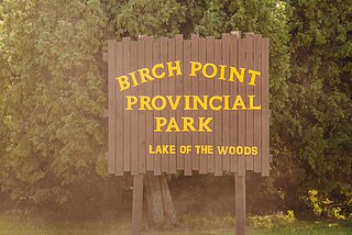
Birch Point Provincial Park is a provincial park located on Buffalo Bay, Lake of the Woods in Manitoba, Canada., about 160 kilometres (99 mi) southeast of Winnipeg. It is 13.1 hectares (0.051 sq mi) in size. It was designated as a Provincial Park in 1961.

Pasquia Hills are hills in the Canadian province of Saskatchewan. They are located in the east central part of the province in the RM of Hudson Bay No. 394 near the Manitoba border. The hills are the northern most in a series of hills called the Manitoba Escarpment. The Manitoba Escarpment marks the western edge of the pre-historical glacial Lake Agassiz. The other four hills include Porcupine Hills, Duck Mountain, and Riding Mountain.

Sturgeon Bay Provincial Park is a provincial park on the western shore of Lake Winnipeg in Manitoba, Canada. The park is considered to be a Class Ib protected area under the IUCN protected area management categories. It is 144.9 km2 (55.9 sq mi) in size.

References

  1. "Canadian Environmental Sustainability Indicators - Canada.ca". indicators-map.canada.ca. Government of Canada. Retrieved 26 October 2018.
  2. 1 2 3 4 5 "Birds Hill Provincial Park Management Plan" (PDF). Parks and Natural Areas Branch, Government of Manitoba. Feb 2013. Archived from the original (PDF) on 15 July 2017. Retrieved 24 October 2018.
  3. 1 2 A System Plan for Manitoba's Provincial Parks (PDF). Government of Manitoba. 1998. p. 27. Archived from the original (PDF) on 15 July 2017. Retrieved 1 July 2017.
  4. "Birds Hill Provincial Park". Protected Planet. United Nations Environment World Conservation Monitoring Centre. Retrieved 30 June 2017.
  5. 1 2 3 4 "Map AR84-5: Quaternary Geology Map of the Birds Hill Area" (PDF). Province of Manitoba. Retrieved 23 October 2018.
  6. "Chickadee Trail and Viewing Tower". Find Your Favorite Park. Manitoba Parks and Protected Spaces. Archived from the original on 23 October 2018. Retrieved 23 October 2018.
  7. 1 2 3 4 5 6 7 Ferguson, Ian. "Geology of Birds Hill" (PDF). University of Manitoba: Geophysics Field School 2015 Birds Hill Project. University of Manitoba. Retrieved 23 October 2018.
  8. 1 2 Stantec Consulting Ltd. (8 April 2016). "Partnership of the Manitoba Capital Region Assessment of Water Infrastructure" (PDF). Winnipeg Metropolitan Region. Retrieved 23 October 2018.
  9. 1 2 3 4 "Birds Hill Provincial Park, Park Information and Map". Find Your Favorite Park. Manitoba Parks and Protected Spaces. Archived from the original on 16 October 2018. Retrieved 16 October 2018.
  10. "Cedar Bog Self Guiding Trail". www.gov.mb.ca. Manitoba Parks and Protected Spaces. Archived from the original on 22 October 2018. Retrieved 22 October 2018.
  11. 1 2 "Birds Hill Provincial Park - Background Information" (PDF). Manitoba Parks and Protected Spaces. Retrieved 16 October 2018.
  12. Cleveland, Norman J.; Edie, Scott; Grieef, Gordon D.; Holland, George; Koes, Rudolf F.; Maynard, Julia W.; Neily, Wayne P.; Taylor, Peter; Tkachuk, Russell (1988). Birder's Guide to Southeastern Manitoba (Second revised and enlarged ed.). Winnipeg: Manitoba Naturalists Society. p. 9.
  13. Kraushar, Aileen; Beattie, Marion; Edie, Florence; Holland, Edna; Roberts, Frances; Van Slyck, Wyn (1974). Springfield : 1st rural municipality in Manitoba, 1873-1973 . Dugald, Manitoba: Dugald's Women's Institute. p.  320. ISBN   0-919212-40-9.
  14. Goldsborough, Gordon. "Historic Sites of Manitoba: Pine Ridge Cemetery (Birds Hill Provincial Park, RM of Springfield)". Manitoba History. Manitoba Historical Society. Retrieved 21 October 2018.
  15. 1 2 Goldsborough, Gordon. "Historic Sites of Manitoba: Birds Hill Provincial Park Plaque (Birds Hill Provincial Park, RM of Springfield)". Manitoba History. Manitoba Historical Society. Retrieved 21 October 2018.
  16. Kraushar, Aileen; Beattie, Marion; Edie, Florence; Holland, Edna; Roberts, Frances; Van Slyck, Wyn (1974). Springfield : 1st rural municipality in Manitoba, 1873-1973 . Dugald, Manitoba: Dugald's Women's Institute. p.  324. ISBN   0-919212-40-9.
  17. 1 2 3 "Birds Hill Provincial Park Celebrates Its 50th Anniversary". News Releases. Province of Manitoba. Retrieved 22 October 2018.
  18. "John Paul II - 1984 Visit to Canada". www.cccb.ca. Canadian Conference of Catholic Bishops. Retrieved 22 October 2018.
  19. Ostick, Stephen (28 August 1992). "Everything he does...". Winnipeg Free Press: 30.
  20. 1 2 3 "Venue: Birds Hill Provincial Park". 2017 Canada Games. 21 July 2015. Archived from the original on 22 October 2018. Retrieved 21 October 2018.