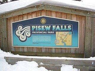
Pisew Falls Provincial Park is a provincial heritage park in the southwestern portion of Mystery Lake, Manitoba, Canada.

Northern Manitoba is a geographic and cultural region of the Canadian province of Manitoba. Originally encompassing a small square around the Red River Colony, the province was extended north to the 60th parallel in 1912. The region's specific boundaries vary, as "northern" communities are considered to share certain social and geographic characteristics, regardless of latitude.

Provincial Road 392 (PR 392) is a provincial road in the Canadian province of Manitoba. It runs from an intersection with Highway 39 to an intersection at Poplar Avenue in Snow Lake. The route was first constructed in 1961, along with spurs to Osborne Lake and Chisel Lake. The route was designated in 1966, along with PR 393 and PR 395 running from the Canadian National Railway station at Wekusko to Snow Lake. The route was truncated in 1994 back to Highway 39 and the stretch from Highway 39 to Wekusko station was re-designated as PR 596.

Vaseux Lake Provincial Park is a provincial park located along the northeastern shore of Vaseux Lake in the Okanagan region of British Columbia, Canada. The park is situated 4 kilometres (2.5 mi) south of Okanagan Falls on Highway 97 in the south Okanagan. The park plays a key role in educating and providing access to important conservation values and has a responsibility to maintain these activities.

Provincial Road 391 (PR 391) is an all-weather gravel road connecting Thompson and Lynn Lake, in the Canadian province of Manitoba. PR 391 is located in the Wapisu Range. PR 391 passes through Leaf Rapids, a community situated northwest of Thompson. Lynn Lake is the last town PR 391 traverses, where it ends at an intersection with PR 394 and PR 396.
Payuk Lake is a glacial lake located nine kilometres (5.6 mi) southeast of Bakers Narrows, Manitoba, Canada.
Neso Lake is a glacial lake on the Mistik Creek chain in the Hudson Bay drainage basin in the Northern Region of Manitoba, Canada. It sits in the Churchill River Upland portion of the Midwestern Canadian Shield forests which consist of mixed coniferous forest trees. The region around the lake consists of rocky parallel ridges with poorly drained areas of muskeg and irregular rocky shorelines due to intense glaciation. The lake is situated on the well known "Mistik Creek Loop", a remote canoe route which is 95 km (59 mi) in total length and can be paddled in four days.

Nisto Lake is a glacial lake on the Mistik Creek chain in the Hudson Bay drainage basin in the Northern Region of Manitoba, Canada. It sits in the Churchill River Upland portion of the Midwestern Canadian Shield forests which consist of mixed deciduous and coniferous trees. The region around the lake consists of rocky parallel ridges with poorly drained areas of muskeg and irregular rocky shorelines due to intense glaciation. The lake is situated on the well-known "Mistik Creek Loop", a remote canoe route which is 80 km in total length can be paddled in four days.
Nao Lake is a glacial lake on the Mistik Creek chain in the Hudson Bay drainage basin in the Northern Region of Manitoba, Canada. It sits in the Churchill River Upland portion of the Midwestern Canadian Shield forests which consist of mixed deciduous and coniferous trees. The region around the lake consists of rocky parallel ridges with poorly drained areas of muskeg and irregular rocky shorelines due to intense glaciation. The lake is situated on the well known "Mistik Creek Loop", a remote canoe route 95 km (59 mi) in length which can be paddled in four days.

Niyanun Lake is a glacial lake on the Mistik Creek chain in the Hudson Bay drainage basin in the Northern Region of Manitoba, Canada.

Nikotwasik Lake is narrow glacial lake on the Mistik Creek chain beneath the Vamp Creek confluence. It is in the Hudson Bay drainage basin in the Northern Region of Manitoba, Canada. It sits in the Churchill River Upland portion of the Midwestern Canadian Shield forests which consist of mixed deciduous and coniferous trees.

Tapukok Lake is narrow glacial lake on the Mistik Creek chain above the Vamp Creek confluence. It is approximately 19 kilometres (12 mi) northeast of Bakers Narrows and is situated in the Hudson Bay drainage basin in the Northern Region of Manitoba, Canada. It is surrounded by the Churchill River Upland portion of the Midwestern Canadian Shield forests which consist of mixed deciduous and coniferous trees.

Uyenanao Lake is a glacial lake on the Mistik Creek chain, approximately 20 kilometres (12 mi) northeast of Bakers Narrows. It is part of the Nelson River watershed, in the Hudson Bay drainage basin in the Northern Region of Manitoba, Canada. The surrounding mixed deciduous and coniferous forest is part of the Churchill River Upland portion of the Midwestern Canadian Shield forests. The region around the lake consists of rocky parallel ridges with poorly drained areas of muskeg and irregular stony shorelines due to intense glaciation. The lake is situated on the well known "Mistik Creek Loop", a remote canoe route 80 kilometres (50 mi) in length which can be paddled in four days.

Kakat Lake is a glacial lake at the confluence of Holt Lake and Mistik Creek, approximately 21 kilometres (13 mi) northeast of Bakers Narrows. As a segment of the Mistik Creek, it is part of the Nelson River watershed, in the Hudson Bay drainage basin in the Northern Region of Manitoba, Canada. The surrounding mixed deciduous and coniferous forest is part of the Churchill River Upland portion of the Midwestern Canadian Shield forests. The region around the lake consists of rocky parallel ridges with poorly drained areas of muskeg and irregular stony shorelines due to intense glaciation. The lake is situated on the well known "Mistik Creek Loop", a remote canoe route 95 kilometres (59 mi) in length which can be paddled in four days.

Payukosap Lake is a glacial lake above the confluence of Holt Lake and Mistik Creek, approximately 23 kilometres (14 mi) northeast of Bakers Narrows. As a segment of the Mistik Creek, it is part of the Nelson River watershed, in the Hudson Bay drainage basin in the Northern Region of Manitoba, Canada. The surrounding mixed deciduous and coniferous forest is part of the Churchill River Upland portion of the Midwestern Canadian Shield forests. The region around the lake consists of rocky parallel ridges with poorly drained areas of muskeg and irregular stony shorelines due to intense glaciation. The lake is situated on the well known "Mistik Creek Loop", a remote canoe route 80 kilometres (50 mi) in length which can be paddled in four days.

Nistosap Lake is a glacial lake on the Mistik Creek chain, approximately 22 kilometres (14 mi) northeast of Bakers Narrows. As a segment of the Mistik Creek, it is part of the Nelson River watershed, in the Hudson Bay drainage basin in the Northern Region of Manitoba, Canada.

The Grass River is a historically important waterway in the Hudson Bay drainage basin in the Northern Region of Manitoba, Canada. It begins at the Cranberry Lakes approximately 27 kilometres (17 mi) east of Cranberry Portage and runs northeast 500 kilometres (310 mi) to its mouth on the Nelson River. The river was a critical route for earlier European explorers and was part of the "Upper Tract" of the fur trade into Canadian interior.

Provincial Road 304 is a provincial road in eastern Manitoba, Canada. It begins at PTH 59/PTH 12 south of Grand Beach and runs to Powerview-Pine Falls at the PTH 11 junction. Near the town, PR 304 crosses the Winnipeg River at the Pine Falls Generating Station, operated by Manitoba Hydro. From there, PR 304 heads north and then east to the community of Bissett, before terminating at Provincial Road 314 near the northern boundary of Nopiming Provincial Park.
Colvin Lake Provincial Park is a provincial park in Manitoba, Canada, designated by the Government of Manitoba in 2010. The park is 1,630 km2 (630 sq mi) in size. It is considered a Class Ib protected area under the International Union for Conservation of Nature (IUCN) protected-area management categories.

