North Point Douglas

Last updated
North Point Douglas
Typeneighbourhood in Winnipeg, Manitoba, Canada.
Location Winnipeg, Manitoba, Canada
Established1812
Governing body Parks Canada
Website collection of photos of the neighbourhood

North Point Douglas is a small neighbourhood located in the city of Winnipeg, Manitoba, Canada.

Contents

North Point Douglas comprises the northern portion of a peninsula of the Red River. Its boundaries are Main Street (west), Redwood Avenue (north), the Red River (east), and the Canadian Pacific Railway mainline (south), which bisects the peninsula. The southern portion of the peninsula is the neighbourhood of South Point Douglas (which is also considered part of Downtown Winnipeg.) Together, these two neighbourhoods are known simply known as "Point Douglas". In 2001, North Point Douglas had a population of 2,260.

North Point Douglas is one of the Winnipeg's oldest neighbourhoods. Today, North Point Douglas boasts two of Winnipeg's oldest houses - Barber House and Ross House Museum. It is also considered part of Winnipeg's North End.

History

The eastern point of the neighbourhood was a traditional gathering place for Aboriginal tribes for ceremonial rites (while The Forks nearby was traditionally used for trading purposes). This is believed to have occurred prior to European contact, and continued until urbanization in the 1870s.

In 1812, this first group of Selkirk Settlers arrived in Point Douglas and began raising wheat crops on the point and along the Red River, becoming the first agrarian colony west of the Great Lakes.

As the Red River Colony (as the Winnipeg region was known) grew, a small cluster of commercial establishments developed on the Fort Garry road at Point Douglas by 1862, notably those of William Fonseca and Edmond Barber. After the incorporation of the City of Winnipeg in 1873, Point Douglas developed as a neighbourhood. Several notable citizens resided there, including merchant James Ashdown and Manitoba premier John Norquay. Among the houses of these men, there developed more modest cottages, industry such as Brown and Rutherford, a lumber company established in Point Douglas in 1872.

In 1881, Point Douglas was selected as the location that the Canadian Pacific Railway would cross the Red River. This move solidified Point Douglas as a choice location for industrial firms, who could take advantage of proximity to the railway. With the railroad completed by 1885, Winnipeg experienced an intense period of growth, and by 1914, Point Douglas had become a densely populated working-class neighbourhood, with many immigrants from Eastern Europe.

Today

North Point Douglas continues to be primarily a residential neighbourhood but is also home to commercial and light industrial uses, with industry located mainly on the south side of the neighbourhood along the CPR tracks and commercial establishments on the western side, along Main Street, one of the city's busiest thoroughfares.

North Point Douglas is immediately north of Downtown Winnipeg and is considered part of Winnipeg's inner city. It has faced many of the same challenges that have characterized the North American city in the postwar decades: population and economic decline, crime, drug abuse, and a lack of investment. In recent years, the neighbourhood has begun to stabilize by efforts by community groups like the Point Douglas Residents Committee and North End Community Renewal Corporation and through new and long-time residents renovating properties.

Ross House

Ross House Museum Rosshousemuseum.jpg
Ross House Museum

Ross House had its beginnings in 1852 when construction commenced on William Ross's log home. The museum was moved to its current location at 140 Meade Street (Joe Zuken Heritage Park, Point Douglas) in 1984. The construction of Ross House is a prime example of a Red River frame building. [1]

Crime

North Point Douglas has very high crime rates. In 2012, there were 38 robberies (1707.9 per 100,000 residents), [2] 33 auto thefts (1483.1), 76 break-ins (3415.7) and 2 shootings (89.9). The robbery rate is 22 times higher than the national rate (79 per 100,000 residents). [3]

Demographics

The population of North Point Douglas in 2006 was 2,225 people. [4] The average household income is $31,029, which is about half the average income of Winnipeg as a city. The racial make up of North Point Douglas was:

Related Research Articles

Winnipeg Capital city of Manitoba, Canada

Winnipeg is the capital and largest city of the province of Manitoba in Canada. It is centred on the confluence of the Red and Assiniboine rivers, near the longitudinal centre of North America.

St. Johns (electoral district) Provincial electoral district in Manitoba, Canada

St. Johns is a provincial electoral division in the Canadian province of Manitoba. It was created by redistribution in 1957, and has formally existed since 1958. It is located in the north-end of Winnipeg. The constituency is bordered by Kildonan to the north and west, Burrows to the west, Elmwood to the east, and Point Douglas to the south.

Burrows (electoral district) Provincial electoral district in Manitoba, Canada

Burrows is a provincial electoral division in the Canadian province of Manitoba. It was created by redistribution in 1957 from part of Winnipeg North, and formally came into existence in the provincial election of 1958. The riding is located in the northern part of Winnipeg.

Point Douglas Provincial electoral district in Manitoba, Canada

Point Douglas is a provincial electoral district in Winnipeg, Manitoba, Canada. It is named for a part of the city that is surrounded by a bend in the Red River. The riding covers the neighbourhoods of William Whyte, Dufferin Industrial, North Point Douglas, Lord Selkirk Park and South Point Douglas plus parts of St. John's Park, St. John's, Inkster-Faraday, Burrows Central, Robertson, Dufferin, Logan C.P.R., Civic Centre and the Exchange District. It was also Winnipeg's only government supported red light district.

Wolseley (Manitoba electoral district) Provincial electoral district in Manitoba, Canada

Wolseley is a provincial electoral division in the Canadian province of Manitoba. It was created by redistribution in 1957, and has formally existed since the 1958 provincial election. The riding is located in the centre of the City of Winnipeg. It is named for Col. Garnet Joseph Wolseley, the nineteenth-century army officer who played a significant role in crushing the Red River Rebellion in 1870.

Minto (electoral district) Defunct provincial electoral district in Manitoba, Canada

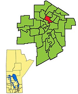
Minto was a provincial electoral division in the Canadian province of Manitoba. It was created by redistribution in 1999, and has formally existed since the provincial election of 1999. The riding is located in the centre of the City of Winnipeg.

East Kildonan, Winnipeg Suburban community in southeast Manitoba.

East Kildonan is a primarily residential community in northeast Winnipeg, Manitoba, Canada. Commonly known by its initials EK, the suburb has a population of approximately 35,800 as of the 2016 Census.

Transcona, Winnipeg suburb of Winnipeg

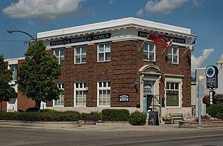
Transcona is a ward and suburb of Winnipeg, Manitoba, located about 10 kilometres (6.2 mi) east of the downtown area.

Wolseley, Winnipeg Place in Manitoba, Canada

Wolseley is a neighbourhood located within the West End of Winnipeg, Manitoba. It is named for field marshal Sir Garnet Wolseley, a British Army officer who came to Manitoba in 1870 to suppress the Red River Rebellion.

Old Kildonan Suburb of Winnipeg, Canada

Old Kildonan is the northernmost city ward of Winnipeg, Manitoba. Before the City of Winnipeg Act of 1972, it was an independent unincorporated municipality called the Municipality of Old Kildonan; prior to that, from 1914, it was a subdivision of the Rural Municipality of Kildonan.

Fort Rouge, Winnipeg

Fort Rouge is a district of Winnipeg, Manitoba. Located in the south-central part of the city, it is bounded on the north by the Assiniboine River, on the east and south by the Red River, and on the west by Stafford Street and Pembina Highway.

West End, Winnipeg Neighbourhood in Winnipeg, Manitoba, Canada

The West End is a mostly residential area of Winnipeg, Manitoba, Canada. It includes the neighbourhoods of Armstrong's Point, Colony, Daniel McIntyre, Minto, Sargent Park, Spence, St. Matthews, West Broadway, and Wolseley.

North End, Winnipeg Neighbourhood in Winnipeg, Manitoba, Canada

Winnipeg's North End is a large urban area located to the north and northwest of Downtown Winnipeg. It is bordered by the Red River on the east, the Canadian Pacific Railway (CPR) mainline on the south, the City of Winnipeg boundary on the west and Jefferson Avenue, Keewatin Street, Carruthers Avenue, McGregor Street and the lane between McAdam and Smithfield Avenues on the north. It is the northern section of the City of Winnipeg as it existed prior to the 1972 municipal amalgamation. Winnipeg's northern suburbs such as West Kildonan and Old Kildonan are not considered part of the North End. The CPR mainline and its Winnipeg yards, which are one of the largest railway yards in the world, act as a physical barrier between the North End and the rest of Winnipeg to the south. This has resulted in the North End remaining a very distinct and unique part of Winnipeg.

The municipal government of Winnipeg is represented by 15 city councillors and a mayor elected every four years.

Elmwood, Winnipeg

Elmwood is a primarily working-class residential area of Winnipeg, Manitoba. It is the only part of the historic city of Winnipeg located east of the Red River.

Varsity View, Winnipeg

Varsity View is one of the original neighbourhoods of the Charleswood community in Winnipeg, Manitoba, Canada, and also a part of the Assiniboine South neighbourhood cluster.

History of Winnipeg

The history of Winnipeg comprises its initial population by Aboriginal peoples through its settlement by Europeans to the present day. The first forts were built on the future site of Winnipeg in the 1700s, followed by the Selkirk Settlement in 1812. Winnipeg was incorporated as a city in 1873 and experienced dramatic growth in the late 19th and early 20th centuries. Following the end of World War I, the city's importance as a commercial centre in Western Canada began to wane. Winnipeg and its suburbs experienced significant population growth after 1945, and the current City of Winnipeg was created by the unicity amalgamation in 1972.

Central Park (Winnipeg) Neighbourhood in Winnipeg, Manitoba, Canada

Central Park is a large urban park located in downtown Winnipeg, and forms the heart of the neighbourhood of the same name.

Linden Woods, Winnipeg Neighbourhood in Winnipeg, Manitoba, Canada

Linden Woods is a neighbourhood in the Fort Garry area of southwest Winnipeg, Manitoba, Canada.

Centennial, Winnipeg Neighbourhood in Winnipeg, Manitoba, Canada

Centennial is an inner-city neighbourhood located Winnipeg, Manitoba, Canada, in the Downtown East Neighbourhood Cluster. The boundaries of Centennial are Sherbrook Street on the west, Logan Avenue on the north, William Avenue on the south and Stanley, Paulin and Adelaide streets on the east.

References

  1. "Ross House Museum". sevenoakshouse.ca. Retrieved February 14, 2020.
  2. Crime in Winnipeg by Neighbourhoods (2012) [ permanent dead link ], info gathered from CrimeStat. Retrieved December 3rd, 2013
  3. Police-reported crime for selected offences, Canada, 2011 and 2012. Retrieved December 3rd, 2013
  4. 1 2 2006 Census (North Point Douglas) Retrieved December 3rd, 2013

Coordinates: 49°54′32″N97°07′42″W / 49.90889°N 97.12833°W / 49.90889; -97.12833