
Winnipeg South Centre is a federal electoral district in Manitoba, Canada, that has been represented in the House of Commons of Canada from 1925 to 1979 and since 1988.

Charleswood is a residential community and neighbourhood in Winnipeg, Manitoba, Canada. It is located in the South-West of the city and is bordered by the neighbourhoods Tuxedo to the East, Fort Whyte to the South, and the Rural Municipality of Headingley on the West. It's boundaries are Roblin and the Assiniboine River to the north, Shaftesbury Boulevard on the East, Wilkes Avenue to the South and the Perimeter Highway to the West.
East Kildonan is a primarily residential community in northeast Winnipeg, Manitoba, Canada. Commonly known by its initials EK, the suburb has a population of approximately 35,800 as of the 2016 Census.
St. Vital is a ward and neighbourhood of Winnipeg, Manitoba, Canada.
River Heights is a suburb and community area in Winnipeg, Manitoba. It is bordered by Route 90 to the west, the Assiniboine River to the north, Cambridge Street to the east, and Taylor Avenue to the south.

Fort Rouge is a district of Winnipeg, Manitoba, in Canada. Located in the south-central part of the city, it is bounded on the north by the Assiniboine River, on the east and south by the Red River, and on the west by Stafford Street and Pembina Highway.
North Kildonan is a city ward in northern Winnipeg, and a former municipality in Manitoba, Canada. Its population as of 2016 was 44,664.

St. James-Assiniboia is a major community area in Winnipeg, Manitoba, Canada. As it encapsulates most of the city ward of St. James, which includes the major St. James Street, the area itself is often simply referred to "St. James."

Downtown Winnipeg is an area of Winnipeg located near the confluence of the Red and Assiniboine rivers. It is the oldest urban area in Winnipeg, and is home to the city's commercial core, city hall, the seat of Manitoba's provincial government, and a number of major attractions and institutions.

The West End is a mostly residential area of Downtown Winnipeg, Manitoba, Canada. It includes the neighbourhoods of Armstrong's Point, Colony, Daniel McIntyre, Minto, Sargent Park, Spence, St. Matthews, West Broadway, and Wolseley.

St. Norbert is a bilingual neighbourhood and the southernmost suburb of Winnipeg, Manitoba, Canada. While outside the Perimeter Highway, it is still part of the city. As of the 2016 Census, the population of St. Norbert is 5,850.

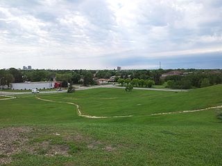
Winnipeg lies at the bottom of the Red River Valley, a low-lying flood plain with an extremely flat topography. This valley was formed by the ancient glacial Lake Agassiz which has rich deposits of black soil. Winnipeg is on the eastern edge of the Canadian Prairies in Western Canada; it is known as the 'Gateway to the West'. It is relatively close to many large Canadian Shield lakes and parks, as well as Lake Winnipeg. Winnipeg is bordered by tallgrass prairie to the west and south and the aspen parkland to the northeast.
Windsor, Ontario, has a very diverse population, and this diversity is shown in its many neighbourhoods. Windsor has twenty in all, ranging from rural farmland to densely built-up areas.

Princess Gardens is a neighbourhood in Toronto, Ontario, Canada. It is located in the western area of Toronto that was formerly the City of Etobicoke. Its boundaries are Eglinton Avenue to the north, Martin Grove to the west, Islington to the east, and Rathburn Road to the south. The southeastern part of this area is the separate neighbourhood of Thorncrest Village. The neighbourhood is divided into two areas: The portion east of Kipling Road is known as Princess Anne Manor, while the portion west of Kipling is Princess Margaret Gardens. They are named after Princess Anne, Princess Royal, and Princess Margaret, Countess of Snowdon, the daughter and sister of the late Queen Elizabeth II respectively. Both Princesses visited the Gardens and opened up Princess Margaret Public School during its opening ceremony. The southwestern part of the neighbourhood is also sometimes known as Glen Agar. Princess Gardens has some of the highest income Canadians in the Greater Toronto Area according to a 2016 census, at an average of $222,218 per year.
Elm Park is a neighbourhood in the city of Winnipeg, Manitoba, Canada. Located in the northern section of the district of St. Vital, it is bounded to the north by the Red River, to the east by St. Mary's Road, to the south by Fermor Avenue, and to the west by Dunkirk Drive. As of the 2021 census, Elm Park had a population of 1,435.

Route 52 is a major north-south arterial route in Winnipeg, Manitoba, Canada. It comprises all of Main Street, Queen Elizabeth Way, and St. Mary's Road.
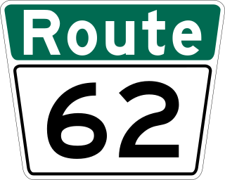
Route 62 is a major north–south arterial route in Winnipeg, Manitoba that has eight different street names.

Varennes is a neighbourhood in the city of Winnipeg, Manitoba, Canada, located in the northern section of the district of St. Vital. It is a small triangular neighbourhood located, and is bounded by St. Mary's Road on the west, Fermor Avenue on the south, and St. Anne's Road on the east. In the 2001 census, Varennes had a population of 1,080.
Minnetonka is a neighbourhood in the city of Winnipeg, Manitoba, Canada, located in the southern section of the district of St. Vital. It is bounded by the Red River on the west and south, Abinojii Mikanah on the north, and St. Mary's Road on the east. As of the 2016 census, Minnetonka had a population of 4,285. On some maps, Minnetonka is called Riel.

